Bretby

Settlement in Derbyshire South Derbyshire

England

Bretby

Repton Shrubs Most of the gridsquare is taken up by Repton Shrubs which is an area of woodland owned by the Forestry Commission. Unfortunately there is only one footpath that runs along the north edge of the woods.
Repton Shrubs Credit: Rob Court

Bretby is a small village located in the South Derbyshire district of Derbyshire, England. Situated approximately five miles southwest of Burton upon Trent, it is nestled in the picturesque countryside of the National Forest. The village is known for its tranquility and natural beauty, making it an ideal destination for those seeking a peaceful retreat.

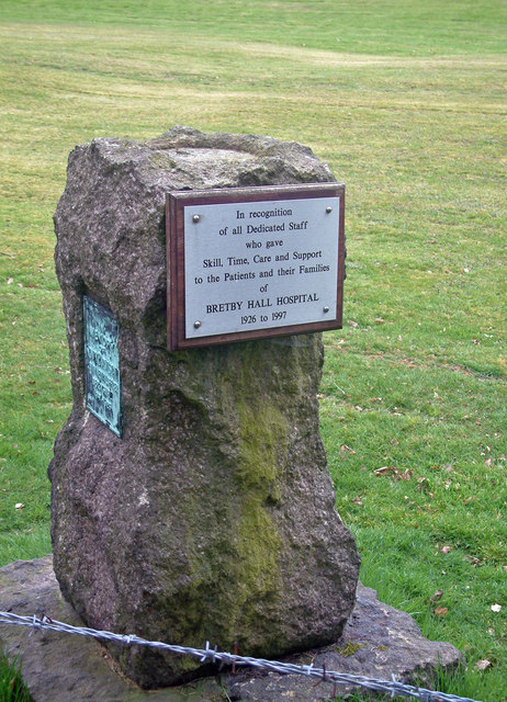
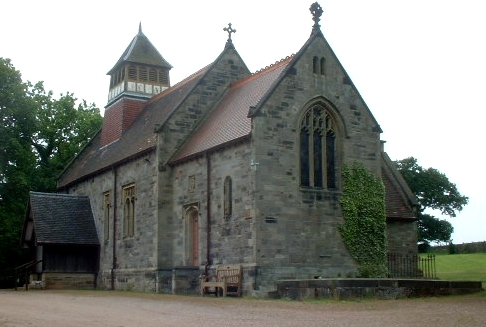
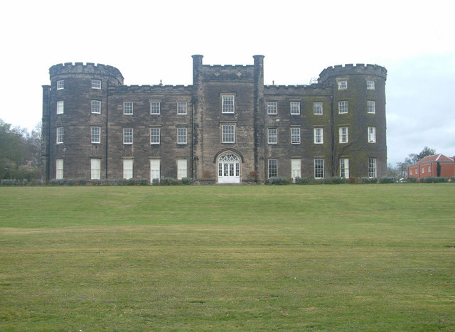
Bretby is renowned for its historical significance, particularly its connections to the Bretby Hall estate. The grand Bretby Hall, a Grade II listed building, was once the seat of the Earls of Chesterfield. The estate has a rich history dating back to the 14th century and features stunning gardens and parklands, which are often open to the public for exploration.

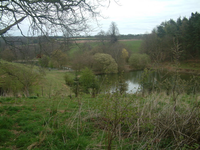
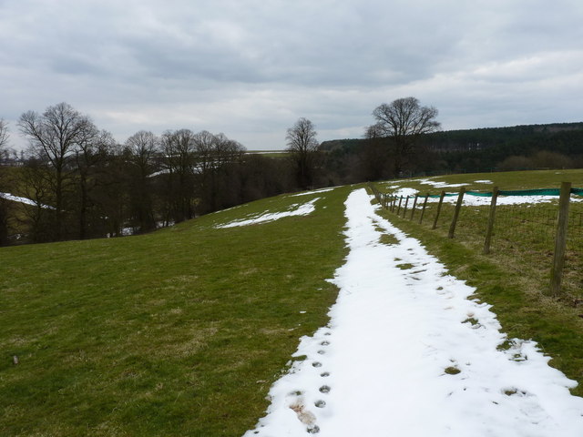
Surrounded by lush greenery, the village offers ample opportunities for outdoor activities. Bretby Park, adjacent to the village, is a popular spot for walking, jogging, and picnicking, with its well-maintained paths and open spaces. The nearby Foremark Reservoir is another attraction, offering scenic walks and water sports like sailing and fishing.

Despite its small size, Bretby enjoys a close-knit community atmosphere. The village has a local pub, The Cross Keys, which serves as a social hub for residents and visitors alike. Additionally, the village is well-connected to nearby towns and cities, with good transport links via road and rail.

In summary, Bretby is a charming village nestled in the heart of Derbyshire's countryside. With its rich history, stunning landscapes, and close-knit community, it offers a serene escape for those seeking a taste of rural England.

If you have any feedback on the listing, please let us know in the comments section below.

Bretby Images

Images are sourced within 2km of 52.806247/-1.561477 or Grid Reference SK2923. Thanks to Geograph Open Source API. All images are credited.

Repton Shrubs Most of the gridsquare is taken up by Repton Shrubs which is an area of woodland owned by the Forestry Commission. Unfortunately there is only one footpath that runs along the north edge of the woods.
Repton Shrubs
Most of the gridsquare is taken up by Repton Shrubs which is an area of woodland owned by the Forestry Commission. Unfortunately there is only one footpath that runs along the north edge of the woods.
Farmland West of Bretby Mill Much of this grid square is taken up with sheep farming.
Farmland West of Bretby Mill
Much of this grid square is taken up with sheep farming.
Hill Farm
Hill Farm
Flood Noahs Ark is a dwelling built on high ground. Foresight perhaps?
Flood
Noahs Ark is a dwelling built on high ground. Foresight perhaps?
Undulating Sheep on the hills west of Hoofies Farm
Undulating
Sheep on the hills west of Hoofies Farm
Moxon's Hill Moxon's Hill near Hoofies Farm
Moxon's Hill
Moxon's Hill near Hoofies Farm
Bretby Hall Converted Hospital
Bretby Hall
Converted Hospital
Monument at Bretby
Monument at Bretby
Lakes at Bretby Hall The lakes viewed from the footpath running along the Southern edge of Bretby Hall. The strip of land separating these two lakes provides the crossing point of the footpath from Bretby to Hoolies wood and from there to either Upper Midway or Hartshorne.
Lakes at Bretby Hall
The lakes viewed from the footpath running along the Southern edge of Bretby Hall. The strip of land separating these two lakes provides the crossing point of the footpath from Bretby to Hoolies wood and from there to either Upper Midway or Hartshorne.
Collarbone Canon
Collarbone Canon
Bretby Park, Bretby Built by the fifth Earl of Chesterfield, begun in 1813 and unfinished when he died in 1815. This show front was probably designed by Jeffry Wyatville. Grade II* listed.
For much of the C20th it housed a hospital, but has now been converted to flats.
Bretby Park, Bretby
Built by the fifth Earl of Chesterfield, begun in 1813 and unfinished when he died in 1815. This show front was probably designed by Jeffry Wyatville. Grade II* listed. For much of the C20th it housed a hospital, but has now been converted to flats.
White Hollow cottage A delightful rural residence, complete with its market garden.
White Hollow cottage
A delightful rural residence, complete with its market garden.
Road junction The junction of Greysich Lane with Repton Road in the valley.
Road junction
The junction of Greysich Lane with Repton Road in the valley.
The Repton Brook The brook meanders quietly through the woods near the road, crossing under it at a bridge which is undergoing some repair work.
The Repton Brook
The brook meanders quietly through the woods near the road, crossing under it at a bridge which is undergoing some repair work.
Pool at the Dower House One of a series of large ornamental ponds stretching off to the WSW in a valley near Bretby Park.
Pool at the Dower House
One of a series of large ornamental ponds stretching off to the WSW in a valley near Bretby Park.
Barns and bales at Dower House Farm
A bridleway at Dower House Farm The track just south of here past the farm sports signs asking you to keep out (of the Bretby Hall estate, presumably) but this bridleway is a right of way, and quite well marked along the fields.
A bridleway at Dower House Farm
The track just south of here past the farm sports signs asking you to keep out (of the Bretby Hall estate, presumably) but this bridleway is a right of way, and quite well marked along the fields.
The bridleway above Watery Lane
Show me another place!

Bretby is located at Grid Ref: SK2923 (Lat: 52.806247, Lng: -1.561477)

Administrative County: Derbyshire

District: South Derbyshire

Police Authority: Derbyshire

What 3 Words

///deeper.trout.splash. Near Swadlincote, Derbyshire

Nearby Locations

Bretby

Related Wikis

Bretby

Bretby is a village and civil parish in the south of Derbyshire, England, north of Swadlincote and east of Burton upon Trent, on the border between Derbyshire...

Bretby Hall

Bretby Hall is a country house at Bretby, Derbyshire, England, north of Swadlincote and east of Burton upon Trent on the border with Staffordshire. It...

South Derbyshire (UK Parliament constituency)

South Derbyshire is a constituency represented in the House of Commons of the UK Parliament since 2010 by Heather Wheeler, a Conservative. == Boundaries... ==

Repton Rural District

Repton was a rural district in Derbyshire, England from 1894 to 1974. It was created under the Local Government Act 1894 from the part of the Burton upon...

South Derbyshire

South Derbyshire is a local government district in Derbyshire, England. The council is based in the town of Swadlincote. The district also contains numerous...

Bees, Wasps and Ants Recording Society

The Bees, Wasps and Ants Recording Society (BWARS) is a British society dedicated to recording bees, wasps and ants. The recording of these insects is...

William Allitt Academy

William Allitt Academy (formerly William Allitt School) is a co-educational secondary school located in the village of Newhall, Swadlincote in South Derbyshire...

Brizlincote

Brizlincote is a civil parish in Burton upon Trent in East Staffordshire, England. Formerly farmland and a manor lying in Derbyshire, it was added to...

Nearby Amenities

Located within 500m of 52.806247,-1.561477
Bretby
Place: village
Lat/Long: 52.806785/-1.5599709
Post Box
Operator: Royal Mail
Post Box Type: lamp
Ref: DE15 1214
Lat/Long: 52.8056823/-1.5633493
Telephone
Booth: K6
Covered: booth
Lat/Long: 52.8056944/-1.5633284
Waste Basket
Colour: black
Material: metal
Operator: South Derbyshire District Council
Waste: trash
Lat/Long: 52.8057172/-1.5633372
The data included in this document is from www.openstreetmap.org. The data is made available under ODbL.

Have you been to Bretby?

Leave your review of Bretby below (or comments, questions and feedback).