Brentingby

Settlement in Leicestershire Melton

England

Brentingby

B676 eastbound
B676 eastbound Credit: Alex McGregor

Brentingby is a small village located in the county of Leicestershire, England. Situated approximately 10 miles east of Melton Mowbray, the village is nestled in the beautiful countryside of the East Midlands region. With a population of around 200 residents, Brentingby maintains a tight-knit community atmosphere.

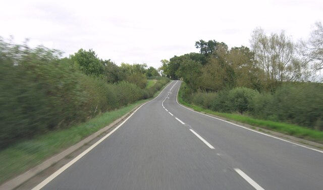
The village is characterized by its picturesque surroundings, featuring rolling hills, lush green fields, and charming country lanes. It offers a peaceful and idyllic environment, making it a desirable place for those seeking a tranquil lifestyle away from the hustle and bustle of larger towns and cities.

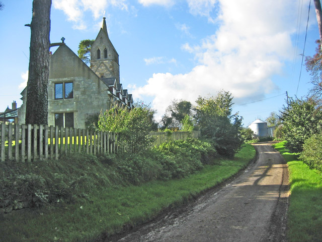
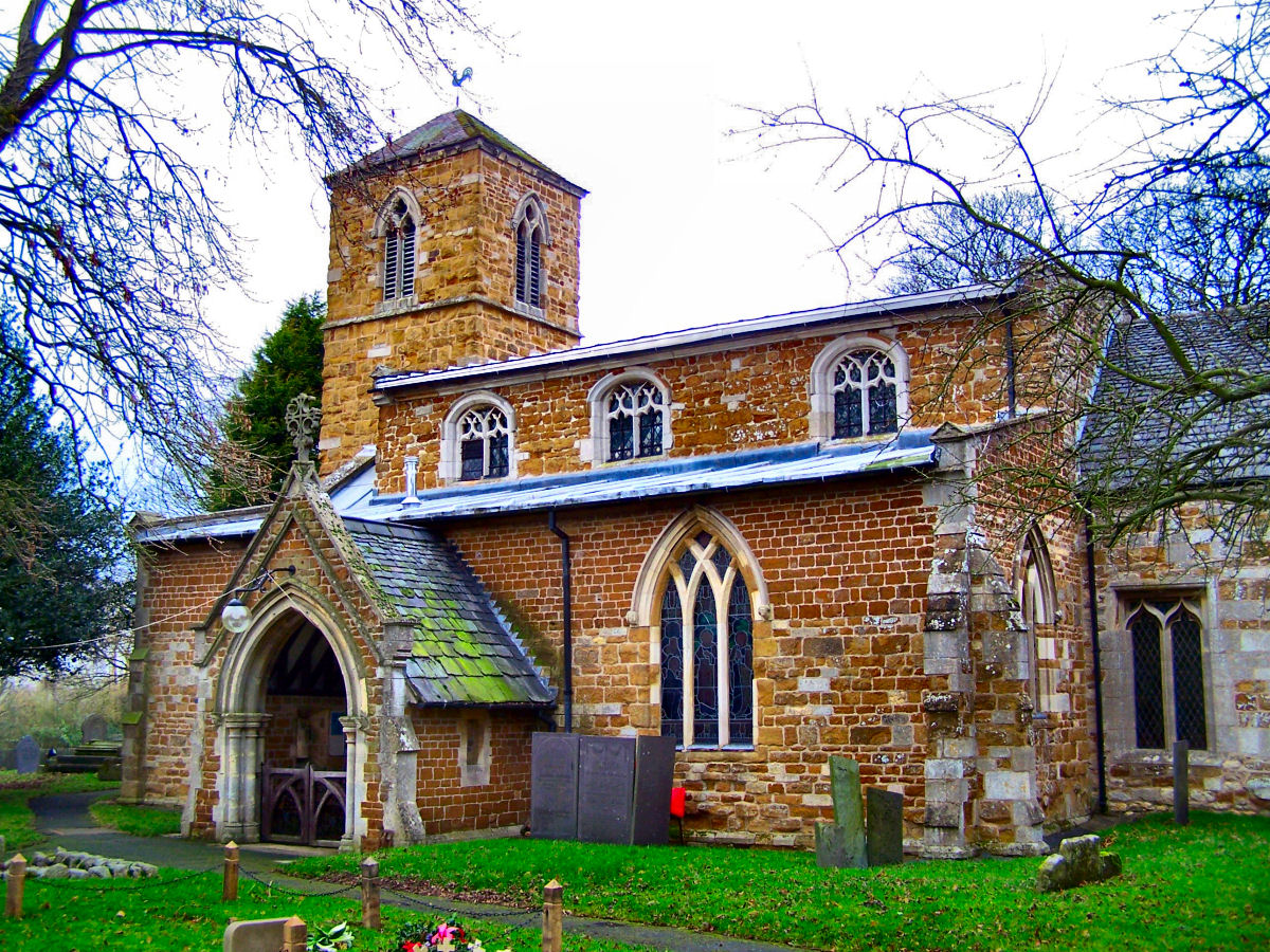
Despite its small size, Brentingby boasts a rich history. The village's origins can be traced back to the medieval period when it was a significant agricultural center. Evidence of its past can still be seen in the form of historic buildings and landmarks. The beautiful St. Mary's Church, constructed in the 13th century, stands as a testament to the village's heritage.

While primarily a residential area, Brentingby also provides ample opportunities for outdoor pursuits and nature exploration. The surrounding countryside offers picturesque walking and cycling routes, allowing residents and visitors to immerse themselves in the area's natural beauty.

Overall, Brentingby is a charming village that offers a peaceful and rural way of life. Its beautiful countryside, historical landmarks, and strong sense of community make it a delightful place to call home.

If you have any feedback on the listing, please let us know in the comments section below.

Brentingby Images

Images are sourced within 2km of 52.760527/-0.836223 or Grid Reference SK7818. Thanks to Geograph Open Source API. All images are credited.

B676 eastbound
B676 eastbound
The Willow Pool If I wanted to dispose of Excalibur, at my Lord's command, this is the sort of place I would fling it.  Ancient, surviving, wrecked willows in a deep pool.

The pool is the remnant of recent rains, when the adjacent River Eye rose and met the torrents falling on the field.  This area is all low-lying wetland, and the Willow is the queen of the landscape.  

This is a stitch of 6 separate images of 6252x4164 pixels, stitched with Microsoft ICE to yield a panoramic shot of 13642x8203 pixels - subsequently downsized to suit Geograph.   The full stitch is available on request.
The Willow Pool
If I wanted to dispose of Excalibur, at my Lord's command, this is the sort of place I would fling it. Ancient, surviving, wrecked willows in a deep pool. The pool is the remnant of recent rains, when the adjacent River Eye rose and met the torrents falling on the field. This area is all low-lying wetland, and the Willow is the queen of the landscape. This is a stitch of 6 separate images of 6252x4164 pixels, stitched with Microsoft ICE to yield a panoramic shot of 13642x8203 pixels - subsequently downsized to suit Geograph. The full stitch is available on request.
Willow in the water One of the trees featured in <a href="https://www.geograph.org.uk/photo/7058886">SK8018 : The Willow Pool</a>.  It is very hard to dissuade a willow from growing, and they revel in wet feet.
Willow in the water
One of the trees featured in SK8018 : The Willow Pool. It is very hard to dissuade a willow from growing, and they revel in wet feet.
Wet enough for thee? One of the Willow trees seen in <a href="https://www.geograph.org.uk/photo/7058886">SK8018 : The Willow Pool</a>.  Broken, wrecked, drowned it still grows vigorously.  This won't be the first time it has stood in floodwater.
Wet enough for thee?
One of the Willow trees seen in SK8018 : The Willow Pool. Broken, wrecked, drowned it still grows vigorously. This won't be the first time it has stood in floodwater.
Ham Bridge  Ham Bridge, on the Eye River.
Ham Bridge
Ham Bridge, on the Eye River.
Downstream The river Eye at Ham Bridge, looking upstream
Downstream
The river Eye at Ham Bridge, looking upstream
Upstream The River Eye from the Ham Bridge
Upstream
The River Eye from the Ham Bridge
Woodland with cow parsley beside Woodfold Lane
Culvert for stream under Woodfold Lane Ordnance Survey documents indicate that a benchmark levelled at 96.238m above Newlyn Datum was verified in 1962 on the culvert
Culvert for stream under Woodfold Lane
Ordnance Survey documents indicate that a benchmark levelled at 96.238m above Newlyn Datum was verified in 1962 on the culvert
Track (also footpath) into Brentingby Lodge Farm Ordnance Survey documents indicate that a benchmark levelled at 114.477m above Newlyn Datum was verified in 1962 on a culvert on the right hand side of the track near the hedge junction
Track (also footpath) into Brentingby Lodge Farm
Ordnance Survey documents indicate that a benchmark levelled at 114.477m above Newlyn Datum was verified in 1962 on a culvert on the right hand side of the track near the hedge junction
Entrance to Brentingby Lodge Farm from Woodfold Lane
Cut Mark Cut mark on Ham bridge on road between Stapleford and Wyfordby, near Melton Mowbray.
Cut Mark
Cut mark on Ham bridge on road between Stapleford and Wyfordby, near Melton Mowbray.
Saxby Road
Saxby Road
Saxby Road
Saxby Road
Saxby Road
Saxby Road
B676 eastbound
B676 eastbound
B676 eastbound
B676 eastbound
B676 eastbound
B676 eastbound
Show me another place!

Brentingby is located at Grid Ref: SK7818 (Lat: 52.760527, Lng: -0.836223)

Administrative County: Leicestershire

District: Melton

Police Authority: Leicestershire

What 3 Words

///input.shuts.beans. Near Melton Mowbray, Leicestershire

Related Wikis

St Mary's Church, Brentingby

St Mary's Church is a redundant Anglican church in the village of Brentingby, Leicestershire, England. The walls of the church required renovation when...

Brentingby

Brentingby is a village in Leicestershire, England.The population is included in the civil parish of Freeby. The village's name means either 'farm/settlement...

River Eye SSSI

River Eye SSSI is a 6.0 hectares (15 acres) biological Site of Special Scientific Interest covering a stretch of the River Eye between Ham Bridge, north...

Thorpe Arnold

Thorpe Arnold is a farming village and former civil parish, now in the parish of Waltham on the Wolds and Thorpe Arnold in the district of Melton, which...

Freeby

Freeby is a village and civil parish in the Melton district of Leicestershire, England, about 3 miles (5 km) east of Melton Mowbray. As well as the village...

Burton Lazars

Burton Lazars is a village and former civil parish, now in the parish of Burton and Dalby, in the Melton district, in the county of Leicestershire, England...

Stapleford Miniature Railway

Stapleford Miniature Railway is an historic steam locomotive-hauled 10+1⁄4 in (260 mm) gauge railway at Stapleford Park, Stapleford near Melton Mowbray...

Stapleford, Leicestershire

Stapleford is a village and former civil parish, now in the parish of Freeby, in the Melton district of Leicestershire, England, east of Melton Mowbray...

Nearby Amenities

Located within 500m of 52.760527,-0.836223
Railway: level_crossing
Lat/Long: 52.7603412/-0.8296066
Brentingby
Created By: Potlatch 0.10f
Place: hamlet
Source: NPE
Wikidata: Q4961691
Lat/Long: 52.7608582/-0.8384577
Bus Stop
St Mary's Church
Bus: yes
Naptan AtcoCode: 260000905
Naptan Bearing: W
Naptan BusStopType: CUS
Naptan CommonName: St Mary's Church
Naptan Indicator: outside
Naptan Landmark: St Mary's Church
Naptan NaptanCode: leidmwtp
Naptan Notes: Non-Hourly - County
Naptan Street: Main Road
Naptan Verified: no
Public Transport: platform
Source: naptan_import
Lat/Long: 52.7612485/-0.8385988
Bus Stop
St Mary's Church
Bus: yes
Naptan AtcoCode: 260000906
Naptan Bearing: E
Naptan BusStopType: CUS
Naptan CommonName: St Mary's Church
Naptan Indicator: opposite
Naptan Landmark: St Mary's Church
Naptan NaptanCode: leidmwtw
Naptan Notes: Non-Hourly - County
Naptan Street: Mian Road
Naptan Verified: no
Public Transport: platform
Source: naptan_import
Lat/Long: 52.7613296/-0.8386115
Power: tower
Source: Bing
Lat/Long: 52.7578523/-0.831862
Power: tower
Source: Bing
Lat/Long: 52.762586/-0.8343755
Power: tower
Source: Bing
Lat/Long: 52.7644462/-0.8353953
Power: tower
Source: Bing
Lat/Long: 52.76454/-0.838968
Power: tower
Source: Bing
Lat/Long: 52.7600697/-0.8330408
Railway: crossing
Source: OS OpenData StreetView
Lat/Long: 52.7595262/-0.8380942
Railway: level_crossing
Lat/Long: 52.7603805/-0.8296227
Railway: crossing
Source: OS OpenData StreetView
Lat/Long: 52.7595664/-0.8380854
Place: farm
Lat/Long: 52.7614169/-0.8402126
The data included in this document is from www.openstreetmap.org. The data is made available under ODbL.

Have you been to Brentingby?

Leave your review of Brentingby below (or comments, questions and feedback).