Zoar
Settlement in Cornwall
England
Zoar

Zoar is a small coastal village located in the county of Cornwall, England. Situated on the south coast, it lies approximately 6 miles east of the popular tourist destination of St. Ives. With a population of around 400 residents, Zoar retains a charming and peaceful atmosphere that attracts visitors looking for a tranquil getaway.
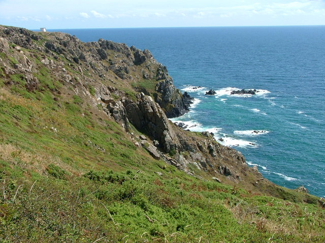
The village is renowned for its picturesque setting, nestled between rolling hills and overlooking the azure waters of the Atlantic Ocean. Its idyllic sandy beach, known as Zoar Bay, offers visitors the opportunity to relax and soak up the sun, while also providing a haven for water sports enthusiasts.
Zoar itself is steeped in history, with evidence of human habitation dating back to the Bronze Age. The village boasts a traditional Cornish charm, with a scattering of whitewashed cottages and narrow winding streets. The local church, St. Mary's, is a prominent feature, showcasing stunning architecture and serving as a focal point for the community.
In terms of amenities, Zoar offers a handful of local businesses, including a small grocery store, a cozy pub, and a handful of boutique shops selling local crafts and artisanal products. The village also hosts an annual summer fair, attracting both locals and tourists with its live music, traditional food stalls, and entertaining activities.
Overall, Zoar provides an ideal escape for those seeking a peaceful retreat amidst breathtaking natural beauty, while also offering a glimpse into Cornwall's rich history and culture.
If you have any feedback on the listing, please let us know in the comments section below.
Zoar Images
Images are sourced within 2km of 50.028917/-5.1289604 or Grid Reference SW7619. Thanks to Geograph Open Source API. All images are credited.


Zoar is located at Grid Ref: SW7619 (Lat: 50.028917, Lng: -5.1289604)
Unitary Authority: Cornwall
Police Authority: Devon and Cornwall
What 3 Words
///suiting.colleague.stroke. Near Mullion, Cornwall
Nearby Locations
Related Wikis

Zoar, Cornwall
Zoar (Cornish: Zoara) is a hamlet on the Lizard Peninsula in south Cornwall, England, UK. It is situated 1+1⁄2 miles (2.4 km) northwest of the coastal...

Three Brothers of Grugith
The Three Brothers of Grugith (Cornish: An Tri Broder a Grugwydh) is a prehistoric site, a dolmen of the Neolithic Age, near St Keverne in Cornwall, England...

Trelan
Trelan (Cornish: Trelann) is a hamlet in the parish of St Keverne in Cornwall, England, United Kingdom, on the eastern borders of Goonhilly Downs.Trelan...
Kennack to Coverack
Kennack to Coverack is a coastal Site of Special Scientific Interest (SSSI) on the Lizard Peninsula in Cornwall, England, UK, noted for both its biological...
Nearby Amenities
Located within 500m of 50.028917,-5.1289604Have you been to Zoar?
Leave your review of Zoar below (or comments, questions and feedback).