Breighton

Settlement in Yorkshire

England

Breighton

Entrance to the airfield
Entrance to the airfield Credit: David Brown

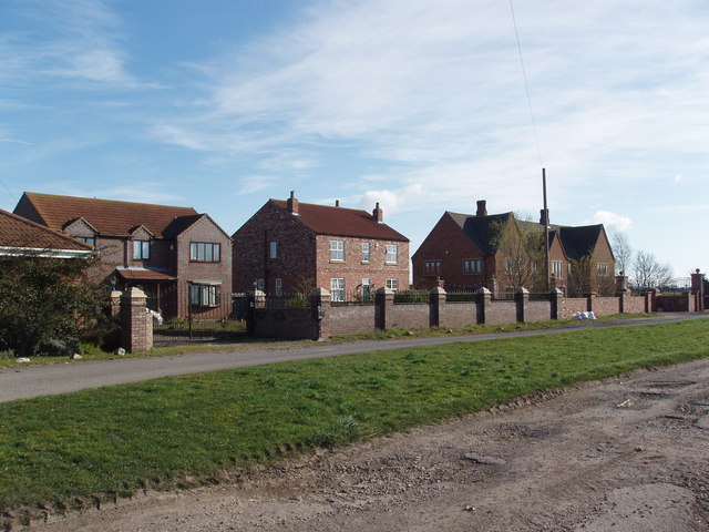
Breighton is a small village located in the East Riding of Yorkshire, England. Situated approximately 11 miles east of York, it falls within the civil parish of Bubwith. The village is surrounded by picturesque countryside, offering a tranquil and idyllic setting.

Breighton is known for its rich history, dating back to the Roman times. Evidence of Roman occupation can be found through the discovery of coins and other artifacts in the area. The village also boasts a medieval church, St. Mary's, which stands as a reminder of its historical roots.

Despite its small size, Breighton has a tight-knit community with a friendly atmosphere. The village is home to a number of amenities, including a village hall, a primary school, and a pub, which acts as a social hub for residents and visitors alike. The pub offers a warm welcome and traditional pub food, making it a popular spot for locals to gather and socialize.

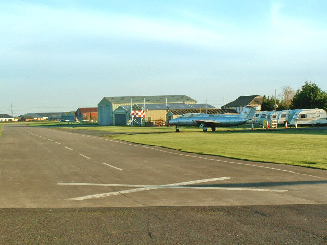
Breighton's rural location makes it a haven for outdoor enthusiasts. The surrounding countryside provides ample opportunities for walking, cycling, and exploring nature. The village is also home to a private airfield, Breighton Aerodrome, which hosts regular aviation events and offers the chance for aviation enthusiasts to take flight.

Overall, Breighton is a charming village that offers a peaceful and close-knit community, rich history, and access to stunning natural landscapes, making it an appealing destination for those seeking a slower pace of life in a picturesque setting.

If you have any feedback on the listing, please let us know in the comments section below.

Breighton Images

Images are sourced within 2km of 53.796913/-0.921895 or Grid Reference SE7133. Thanks to Geograph Open Source API. All images are credited.

Entrance to the airfield
Industrial estate on Breighton Airfield
Footbridge heading to Intake Farm
Fleet Dike
Fleet Dike
North along Breighton Road Looking along the road lined with hedges which leads to Breighton.
North along Breighton Road
Looking along the road lined with hedges which leads to Breighton.
Road to Wressle Looking along Breighton Road towards Wressle.
Road to Wressle
Looking along Breighton Road towards Wressle.
Fishing pool along Breighton Road Looking towards a small pond used for angling.
Fishing pool along Breighton Road
Looking towards a small pond used for angling.
Rape beside Breighton Road Drax power station can be seen in the distance.
Rape beside Breighton Road
Drax power station can be seen in the distance.
Field beside the Derwent Looking along Breighton Road as it runs beside the River Derwent.
Field beside the Derwent
Looking along Breighton Road as it runs beside the River Derwent.
River Derwent near Breighton Road Looking towards the River Derwent between Breighton and Wressle.
River Derwent near Breighton Road
Looking towards the River Derwent between Breighton and Wressle.
Horse beside the Derwent Looking towards the River Derwent from Breighton Road.
Horse beside the Derwent
Looking towards the River Derwent from Breighton Road.
Houses along Ferry Lane Looking along Ferry Lane in Breighton.
Houses along Ferry Lane
Looking along Ferry Lane in Breighton.
Houses in Breighton Looking along Sand Lane in the village.
Houses in Breighton
Looking along Sand Lane in the village.
Cottages along Sand Lane Looking towards some houses in Breighton.
Cottages along Sand Lane
Looking towards some houses in Breighton.
Breighton Airfield Looking through the entrance onto the airfield. The runway is 11/29.
Breighton Airfield
Looking through the entrance onto the airfield. The runway is 11/29.
Road beside the airfield Looking along Gunby Road towards Breighton.
Road beside the airfield
Looking along Gunby Road towards Breighton.
Field beside Gunby Road Looking across farmland between Breighton and Bubwith.
Field beside Gunby Road
Looking across farmland between Breighton and Bubwith.
Gunby Road Looking along Gunby Road between Breighton and Bubwith.
Gunby Road
Looking along Gunby Road between Breighton and Bubwith.
Show me another place!

Breighton is located at Grid Ref: SE7133 (Lat: 53.796913, Lng: -0.921895)

Division: East Riding

Unitary Authority: East Riding of Yorkshire

Police Authority: Humberside

What 3 Words

///inhales.passions.dugouts. Near Bubwith, East Yorkshire

Nearby Locations

Breighton Hall Moors

Related Wikis

Breighton

Breighton is a village in the East Riding of Yorkshire, England. It is situated on the east bank of the River Derwent, approximately 5 miles (8 km) north...

Breighton Aerodrome

Breighton Aerodrome is a private aerodrome primarily used for general aviation flying located on the former Royal Air Force Breighton or more simply RAF...

Menthorpe

Menthorpe is a hamlet in the civil parish of North Duffield in North Yorkshire, England. It lies on the west bank of the River Derwent, 6 miles (10 km...

Bubwith railway station

Bubwith railway station was a station on the Selby to Driffield Line in the East Riding of Yorkshire, England serving the village of Bubwith. It opened...

Nearby Amenities

Located within 500m of 53.796913,-0.921895
Post Box
Collection Times: Mo-Fr 16:15; Sa 10:45
Operator: Royal Mail
Post Box Type: lamp
Ref: YO8 42
Lat/Long: 53.7975331/-0.9251486
Telephone
Defibrillator
Booth: KX100
Covered: booth
Defibrillator Location: inside old phone box in Breighton
Emergency: defibrillator
Man Made: telephone_box
Ref GB The Circuit: 3D4A47D4-0E2D-45AA-B77B-AD6B00E7FB88
Lat/Long: 53.7983865/-0.9253051
Breighton Sand Lane
Naptan AtcoCode: 2200YEZ01337
Naptan Bearing: NW
Naptan BusStopType: CUS
Naptan CommonName: Breighton Sand Lane
Naptan Street: Clay Lane
Naptan Verified: no
Source: naptan_import
Lat/Long: 53.798824/-0.9259248
Breighton Sand Lane
Naptan AtcoCode: 2200YEZ01338
Naptan Bearing: SE
Naptan BusStopType: CUS
Naptan CommonName: Breighton Sand Lane
Naptan Street: Ferry Lane
Naptan Verified: no
Source: naptan_import
Lat/Long: 53.7985683/-0.9254758
Breighton
Place: village
Source: OS_OpenData_StreetView
Source Ref: GPS
Wikidata: Q74
Lat/Long: 53.7977485/-0.92438
Barrier: yes
Lat/Long: 53.7969864/-0.9253885
Give Way
Direction: backward
Lat/Long: 53.7982828/-0.9253668
The data included in this document is from www.openstreetmap.org. The data is made available under ODbL.

Have you been to Breighton?

Leave your review of Breighton below (or comments, questions and feedback).