Brèibhig

Settlement in Inverness-shire

Scotland

Brèibhig

Sloc nan Each
Sloc nan Each Credit: Alpin Stewart

Brèibhig, also known as Brora, is a picturesque village located in the county of Inverness-shire, Scotland. Nestled on the eastern coast of the country, Brèibhig sits on the banks of the River Brora and offers stunning views of the North Sea.

The village is renowned for its natural beauty, with its rugged coastline, sandy beaches, and rolling hills. Visitors can enjoy leisurely walks along the shore, exploring the rocky cliffs, or simply basking in the tranquility of the surrounding countryside. The nearby Brora Golf Club is also a popular attraction for golf enthusiasts, offering an 18-hole course with breathtaking views.

Brèibhig has a rich history, dating back to the early 19th century when it became a hub for the coal mining industry. The remnants of the old coal mine can still be seen today, providing visitors with a glimpse into the village's industrial past. The Brora Heritage Centre further showcases the area's history, featuring exhibits on local industries, fishing, and the Highland Clearances.

In terms of amenities, Brèibhig offers a range of facilities to cater to locals and tourists alike. There are several charming shops, cafes, and restaurants where visitors can indulge in traditional Scottish cuisine or purchase unique local crafts. The village also has a primary school, medical center, and various accommodation options, including hotels and bed and breakfasts.

Overall, Brèibhig is a captivating destination that combines natural beauty, historical significance, and a warm sense of community. Whether you are seeking outdoor adventures, cultural experiences, or simply a peaceful retreat, this village in Inverness-shire has something to offer everyone.

If you have any feedback on the listing, please let us know in the comments section below.

Brèibhig Images

Images are sourced within 2km of 56.959654/-7.4442821 or Grid Reference NL6998. Thanks to Geograph Open Source API. All images are credited.

Sloc nan Each
Sloc nan Each
The A888 towards Earsairidh
Beach at Earsairidh
Beach at Earsairidh
Coastal rocks A view at low tide of the coastal rock platform by Earsairidh.
Coastal rocks
A view at low tide of the coastal rock platform by Earsairidh.
Sandy beach on Orasaigh There are four Orasaighs around Barra, it being the Gaelic for small tidal island. The fishing waste on the beach is unfortunately common, though it will do less harm on the beach than on the seabed.
Sandy beach on Orasaigh
There are four Orasaighs around Barra, it being the Gaelic for small tidal island. The fishing waste on the beach is unfortunately common, though it will do less harm on the beach than on the seabed.
Earsairidh, Barraigh
Orasaigh, near Earsairidh
Earsary: postbox № HS9 6 This small postbox stands in a passing place on the A888 - it is emptied at 8:45am on weekdays and at 6:45am on Saturdays.
Earsary: postbox № HS9 6
This small postbox stands in a passing place on the A888 - it is emptied at 8:45am on weekdays and at 6:45am on Saturdays.
Rough sea at Earsairidh A view across Sloc nan Each to Eilean nan Gamhna, and to Bruairnis.
Rough sea at Earsairidh
A view across Sloc nan Each to Eilean nan Gamhna, and to Bruairnis.
Houses at Earsary/Earsairidh The nearer one is on Google Street view imagery dated 2009, the other one is not.
Houses at Earsary/Earsairidh
The nearer one is on Google Street view imagery dated 2009, the other one is not.
Remains of fence on Orosay Looking NE to Mainland Barra.  Taken whilst waiting for the tide to turn to give clearance to kayak through the shallow channel.
Remains of fence on Orosay
Looking NE to Mainland Barra. Taken whilst waiting for the tide to turn to give clearance to kayak through the shallow channel.
Leinis Small grassy peninsula on the east coast of Barra.
Leinis
Small grassy peninsula on the east coast of Barra.
Orasaigh Small island off the east coast of Barra.
Orasaigh
Small island off the east coast of Barra.
Inlet and road at Earsary Barra
Cottage at Earsairidh This apparently isolated cottage on a rocky shore makes an almost classic Hebridean view.
Cottage at Earsairidh
This apparently isolated cottage on a rocky shore makes an almost classic Hebridean view.
Orasaigh This little island is one of a surprisingly large number with the same name, or variants of it.
Orasaigh
This little island is one of a surprisingly large number with the same name, or variants of it.
Leinis Looking south across the rocky shore of the Leinis peninsula.
Leinis
Looking south across the rocky shore of the Leinis peninsula.
Cross-cutting Dykes The dark dyke is an undeformed 'younger basic' dyke cutting across a pegmatitic granite vein which itself cuts through a microdiorite dyke. The pegamtite is not easy to see in this image; it is the pale rock on either side of the narrowest part of the dark mafic dyke.
Cross-cutting Dykes
The dark dyke is an undeformed 'younger basic' dyke cutting across a pegmatitic granite vein which itself cuts through a microdiorite dyke. The pegamtite is not easy to see in this image; it is the pale rock on either side of the narrowest part of the dark mafic dyke.
Show me another place!

Brèibhig is located at Grid Ref: NL6998 (Lat: 56.959654, Lng: -7.4442821)

Unitary Authority: Na h-Eileanan an Iar

Police Authority: Highlands and Islands

Also known as: Brevig

What 3 Words

///dreamers.verges.gone. Near CastleBay, Na h-Eileanan Siar

Related Wikis

Brevig, Barra

Brevig (Scottish Gaelic: Brèibhig) is a village on the island of Barra, in the Outer Hebrides, Scotland. The settlement is situated on the A888, which...

Heaval

Heaval is the highest hill on the Outer Hebridean island of Barra, Scotland. The highest point is 383 metres high above sea level and it is located 1.5...
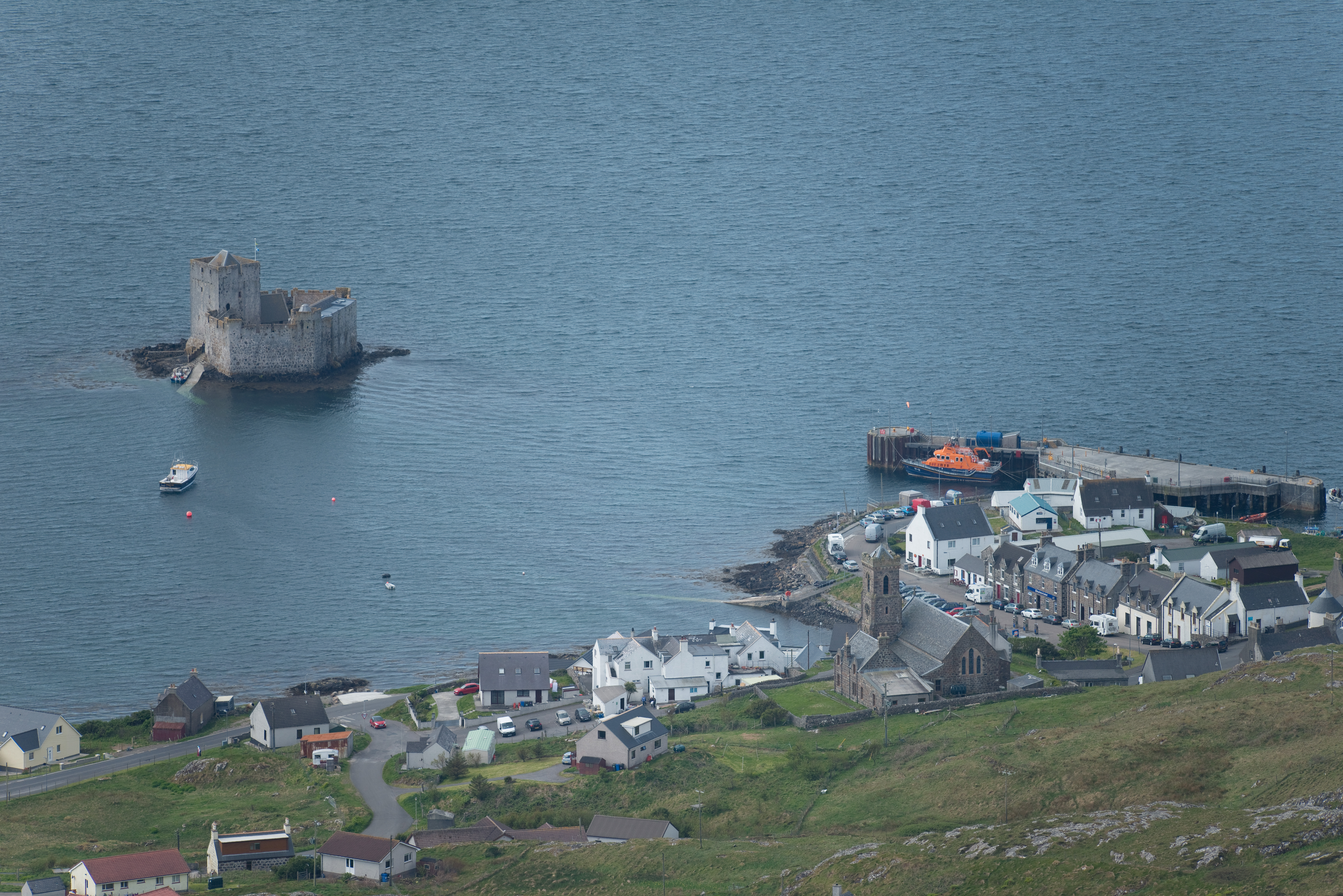
Castlebay

Castlebay (Scottish Gaelic: Bàgh a' Chaisteil [baːɣ ə ˈxaʃtʲɪl]) is the main village and a community council area on the island of Barra in the Outer Hebrides...

Kisimul Castle

Kisimul Castle (Scottish Gaelic: Caisteal Chiosmuil) and also known as Kiessimul Castle, is a medieval castle located on a small island off Castlebay,...

Nearby Amenities

Located within 500m of 56.959654,-7.4442821
Passing Place
Lat/Long: 56.9614563/-7.4498192
Passing Place
Lat/Long: 56.9617323/-7.4421274
Passing Place
Lat/Long: 56.9606296/-7.4432592
Barrier: cattle_grid
Lat/Long: 56.9586557/-7.4419084
Barrier: cattle_grid
Lat/Long: 56.959234/-7.4446819
Passing Place
Lat/Long: 56.9615288/-7.4482608
Passing Place
Lat/Long: 56.9618151/-7.4461321
Barrier: cattle_grid
Lat/Long: 56.9621634/-7.441871
Turning Circle
Lat/Long: 56.9625155/-7.4425364
Passing Place
Lat/Long: 56.9631253/-7.4441818
Post Box
Operator: Royal Mail
Ref: HS9 10
Lat/Long: 56.9635674/-7.4411769
Brèibhig
Name En: Brevig
Name Gd: Brèibhig
Place: village
Wikidata: Q4960411
Wikipedia: en:Brevig
Lat/Long: 56.9625377/-7.4445463
Power: pole
Lat/Long: 56.9639327/-7.4430415
Power: pole
Lat/Long: 56.9635233/-7.4431206
Power: pole
Lat/Long: 56.9630619/-7.4431823
Power: pole
Lat/Long: 56.9625158/-7.4432414
Power: pole
Lat/Long: 56.9620522/-7.4438207
Power: pole
Lat/Long: 56.9615418/-7.4444805
Power: pole
Lat/Long: 56.9610329/-7.4450545
Power: pole
Lat/Long: 56.9601138/-7.4442123
Power: pole
Lat/Long: 56.9600188/-7.445088
Power: pole
Lat/Long: 56.9606184/-7.4456647
Power: pole
Lat/Long: 56.9602857/-7.4460791
Power: pole
Lat/Long: 56.9602243/-7.4472244
Power: pole
Lat/Long: 56.9601548/-7.4482812
Power: pole
Lat/Long: 56.9601087/-7.4492361
Power: pole
Lat/Long: 56.9600532/-7.4502942
Power: pole
Lat/Long: 56.959991/-7.451359
Power: pole
Lat/Long: 56.9599391/-7.4521878
Barrier: cattle_grid
Lat/Long: 56.9620219/-7.4460316
Passing Place
Lat/Long: 56.963448/-7.4422972
Barrier: cattle_grid
Lat/Long: 56.9631116/-7.4448533
Passing Place
Lat/Long: 56.9627176/-7.4450062
Passing Place
Lat/Long: 56.9620332/-7.4457935
Power: pole
Lat/Long: 56.9607431/-7.4510952
Power: pole
Lat/Long: 56.9611123/-7.4515216
Power: pole
Lat/Long: 56.9621917/-7.4426545
Power: pole
Lat/Long: 56.9617523/-7.4425901
Power: pole
Lat/Long: 56.9613356/-7.4428141
Power: pole
Lat/Long: 56.9594492/-7.4445354
Power: pole
Lat/Long: 56.9597618/-7.4443839
Passing Place
Lat/Long: 56.9613252/-7.4471997
Power: pole
Lat/Long: 56.9617543/-7.4470008
Power: pole
Lat/Long: 56.9611094/-7.4462377
Power: pole
Lat/Long: 56.9615291/-7.4467272
Power: pole
Lat/Long: 56.9632224/-7.4458608
Power: pole
Lat/Long: 56.9624182/-7.4460017
Power: pole
Lat/Long: 56.9621118/-7.446467
Power: pole
Lat/Long: 56.9629548/-7.4419247
Power: pole
Lat/Long: 56.963596/-7.4422667
Turning Circle
Turning Circle: knuckle
Lat/Long: 56.9614229/-7.4517744
The data included in this document is from www.openstreetmap.org. The data is made available under ODbL.

Have you been to Brèibhig?

Leave your review of Brèibhig below (or comments, questions and feedback).