Y Cymer

Settlement in Glamorgan

Wales

Y Cymer

Ordnance Survey Cut Mark This OS cut mark can be found on the wall east side of Penrhiwfer Road. It marks a point 174.864m above mean sea level.
Ordnance Survey Cut Mark Credit: Adrian Dust

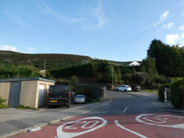
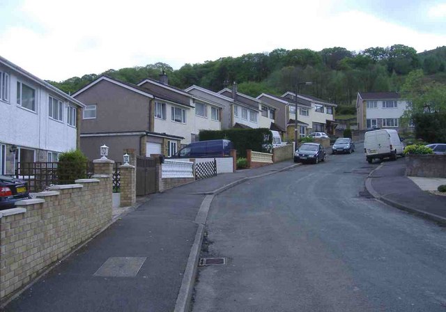
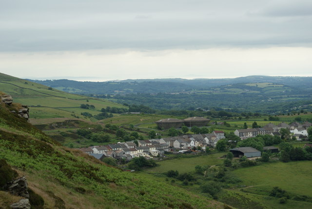
Y Cymer is a small village located in the county of Glamorgan in South Wales. Situated in the picturesque Afan Valley, it is surrounded by stunning natural beauty and offers a peaceful and idyllic setting for its residents and visitors.

The village has a rich history, with evidence of human settlement dating back to prehistoric times. In the past, Y Cymer was primarily a mining community, with coal mining being the main industry that sustained the local economy. However, the decline of the coal industry in the mid-20th century led to a shift in the village's focus.

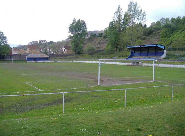
Today, Y Cymer has transformed into a popular tourist destination, attracting outdoor enthusiasts and nature lovers. The nearby Afan Forest Park is renowned for its extensive network of mountain biking trails, offering thrilling experiences for riders of all levels. The surrounding hills and forests also provide ample opportunities for hiking, walking, and exploring the area's diverse flora and fauna.

Despite its small size, Y Cymer has a strong sense of community, with a village hall that hosts various events and activities throughout the year. The local primary school serves the educational needs of the village's children, while a few shops and amenities cater to the basic needs of the residents.

Y Cymer's location, nestled between the Brecon Beacons National Park and the South Wales coastline, makes it an ideal base for exploring the wider region. The village's charm, natural beauty, and friendly atmosphere make it a hidden gem in the heart of Glamorgan.

If you have any feedback on the listing, please let us know in the comments section below.

Y Cymer Images

Images are sourced within 2km of 51.600286/-3.4163392 or Grid Reference ST0290. Thanks to Geograph Open Source API. All images are credited.

Ordnance Survey Cut Mark This OS cut mark can be found on the wall east side of Penrhiwfer Road. It marks a point 174.864m above mean sea level.
Ordnance Survey Cut Mark
This OS cut mark can be found on the wall east side of Penrhiwfer Road. It marks a point 174.864m above mean sea level.
Porth station buildings
Gwaun Bedw bridge over Rhondda River
Porth Railway Station
The Pop Factory, Porth Based in the Rhondda Valley, 15 minutes from Cardiff, The Pop Factory was once home to Corona soft-drinks and is now transformed into a venue with TV studios and post-production facilities that combines the modern with the urban and industrial.

<span class="nowrap"><a title="http://www.thepopfactory.com/index.php" rel="nofollow ugc noopener" href="http://www.thepopfactory.com/index.php">Link</a><img style="margin-left:2px;" alt="External link" title="External link - shift click to open in new window" src="https://s1.geograph.org.uk/img/external.png" width="10" height="10"/></span>
The Pop Factory, Porth
Based in the Rhondda Valley, 15 minutes from Cardiff, The Pop Factory was once home to Corona soft-drinks and is now transformed into a venue with TV studios and post-production facilities that combines the modern with the urban and industrial. LinkExternal link
Porth railway station
Train from Treherbert Approaching Porth, from the west.
Train from Treherbert
Approaching Porth, from the west.
Ken's Barber Shop, Porth Open for business as usual?
Ken's Barber Shop, Porth
Open for business as usual?
Terraced houses, Porth
Eirw Road, Porth
Eirw Road, Porth
Eirw Road, Porth
Eirw Road, Porth
Caemawr Road, Porth
Caemawr Road, Porth
Park Crescent, Porth
Rheola Bridge, Porth The new relief road scheme for Porth includes eight kilometres of new and improved roads and ten bridges.

A landmark feature is the bow string arched Rheola Bridge passing over the two Rhondda rivers, the Treherbert railway line, and the existing A4233 - just north of the town centre.
Rheola Bridge, Porth
The new relief road scheme for Porth includes eight kilometres of new and improved roads and ten bridges. A landmark feature is the bow string arched Rheola Bridge passing over the two Rhondda rivers, the Treherbert railway line, and the existing A4233 - just north of the town centre.
Dinas Road, Dinas
Dinas Road, Dinas
AFC Porth, Dinas Road
Flats, Appletree Avenue, Dinas
Penrhiwfer Road,  Penrhiwfer The church at the top of the street, is St Illtyd's.
Penrhiwfer Road, Penrhiwfer
The church at the top of the street, is St Illtyd's.
Show me another place!

Y Cymer is located at Grid Ref: ST0290 (Lat: 51.600286, Lng: -3.4163392)

Unitary Authority: Rhondda Cynon Taf

Police Authority: South Wales

Also known as: Cymmer

What 3 Words

///operation.sampled.collision. Near Porth, Rhondda Cynon Taf

Related Wikis

Trebanog

Trebanog is a village in the Cymmer electoral ward lying on the southernmost outskirts of the Rhondda Valley, Rhondda Cynon Taf, Wales, located off the...

Porth Community School

Porth Community School is a Community School located in the county borough of Rhondda Cynon Taf, Wales. The school was formed in 1973 by the amalgamation...

Ysgol Gyfun Cwm Rhondda

Ysgol Gyfun Cwm Rhondda (English: Cwm Rhondda Secondary School) is a Welsh-medium secondary school located in the county borough of Rhondda Cynon Taf,...

Mynydd y Glyn

Mynydd y Glyn is a mountain in South Wales, between the towns of Pontypridd and Tonyrefail. It has a height above sea level of 377 metres. It is the mountain...

Glynfach

Glynfach (Welsh for 'small valley') is a district of the community and electoral ward of Cymmer, within the town of Porth, Rhondda Cynon Taf. There are...

Cymmer Colliery explosion

The Cymmer Colliery explosion occurred in the early morning of 15 July 1856 at the Old Pit mine of the Cymmer Colliery near Porth (lower Rhondda Valley...

South Wales Bible Training Institute

The South Wales Bible Training Institute was a Bible college in Porth. It was started by R. B. Jones in 1919. Classes were initially held in his church...

Porth railway station

Porth railway station is a railway station serving the town of Porth in Rhondda Cynon Taf, Wales. It is located on the Rhondda Line. == History == Two...

Nearby Amenities

Located within 500m of 51.600286,-3.4163392
Traffic Signals
Lat/Long: 51.6004033/-3.4219702
Trebanog
Place: village
Wikidata: Q7837340
Lat/Long: 51.6003531/-3.4220511
Mini Roundabout
Lat/Long: 51.599482/-3.4151321
Mini Roundabout
Lat/Long: 51.5990276/-3.4169735
Mini Roundabout
Lat/Long: 51.6001377/-3.4178308
Post Office
Trebanog Post Office
Addr Postcode: CF39 9DU
Branch: Trebanog
Brand: Post Office
Brand Wikidata: Q1783168
Check Date: 2020-02-20
Contact Website: https://www.postoffice.co.uk/branch-finder/4116119/trebanog
Ref Pol Id: 14708
Source: survey
Lat/Long: 51.5998497/-3.4221175
Crossing
Lat/Long: 51.6014473/-3.4219632
Crossing
Lat/Long: 51.6009319/-3.4232527
Crossing
Lat/Long: 51.6006208/-3.4224605
Direction: SSW
Generator Method: photovoltaic
Generator Output Electricity: yes
Generator Solar Modules: 9
Generator Source: solar
Generator Type: solar_photovoltaic_panel
Location: roof
Power: generator
Lat/Long: 51.6026324/-3.4218
Direction: S
Generator Method: photovoltaic
Generator Output Electricity: yes
Generator Solar Modules: 8
Generator Source: solar
Generator Type: solar_photovoltaic_panel
Location: roof
Power: generator
Lat/Long: 51.6016137/-3.4223341
Direction: 195
Generator Method: photovoltaic
Generator Output Electricity: yes
Generator Solar Modules: 18
Generator Source: solar
Generator Type: solar_photovoltaic_panel
Location: roof
Power: generator
Lat/Long: 51.6004966/-3.4170625
Direction: SSE
Generator Method: photovoltaic
Generator Output Electricity: yes
Generator Solar Modules: 18
Generator Source: solar
Generator Type: solar_photovoltaic_panel
Location: roof
Power: generator
Lat/Long: 51.6005006/-3.4172345
Direction: SSW
Generator Method: photovoltaic
Generator Output Electricity: yes
Generator Solar Modules: 18
Generator Source: solar
Generator Type: solar_photovoltaic_panel
Location: roof
Power: generator
Lat/Long: 51.5991082/-3.4168449
Direction: SSW
Generator Method: photovoltaic
Generator Output Electricity: yes
Generator Solar Modules: 18
Generator Source: solar
Generator Type: solar_photovoltaic_panel
Location: roof
Power: generator
Lat/Long: 51.5990005/-3.4165519
Direction: SSW
Generator Method: photovoltaic
Generator Output Electricity: yes
Generator Solar Modules: 18
Generator Source: solar
Generator Type: solar_photovoltaic_panel
Location: roof
Power: generator
Lat/Long: 51.5981131/-3.4167765
Direction: SSW
Generator Method: photovoltaic
Generator Output Electricity: yes
Generator Solar Modules: 18
Generator Source: solar
Generator Type: solar_photovoltaic_panel
Location: roof
Power: generator
Lat/Long: 51.5980333/-3.4165067
Direction: 190
Generator Method: photovoltaic
Generator Output Electricity: yes
Generator Solar Modules: 18
Generator Source: solar
Generator Type: solar_photovoltaic_panel
Location: roof
Power: generator
Lat/Long: 51.597804/-3.4165603
Direction: 190
Generator Method: photovoltaic
Generator Output Electricity: yes
Generator Solar Modules: 18
Generator Source: solar
Generator Type: solar_photovoltaic_panel
Location: roof
Power: generator
Lat/Long: 51.5977922/-3.4164631
Direction: SSW
Generator Method: photovoltaic
Generator Output Electricity: yes
Generator Solar Modules: 18
Generator Source: solar
Generator Type: solar_photovoltaic_panel
Location: roof
Power: generator
Lat/Long: 51.5987006/-3.4156725
Direction: S
Generator Method: photovoltaic
Generator Output Electricity: yes
Generator Solar Modules: 9
Generator Source: solar
Generator Type: solar_photovoltaic_panel
Location: roof
Power: generator
Lat/Long: 51.5990255/-3.4155427
Direction: 185
Generator Method: photovoltaic
Generator Output Electricity: yes
Generator Solar Modules: 4
Generator Source: solar
Generator Type: solar_photovoltaic_panel
Location: roof
Power: generator
Lat/Long: 51.6037686/-3.4184231
Direction: 185
Generator Method: photovoltaic
Generator Output Electricity: yes
Generator Solar Modules: 6
Generator Source: solar
Generator Type: solar_photovoltaic_panel
Location: roof
Power: generator
Lat/Long: 51.6037911/-3.4183889
Direction: 145
Generator Method: photovoltaic
Generator Output Electricity: yes
Generator Solar Modules: 18
Generator Source: solar
Generator Type: solar_photovoltaic_panel
Location: roof
Power: generator
Lat/Long: 51.6046449/-3.4166193
Direction: 145
Generator Method: photovoltaic
Generator Output Electricity: yes
Generator Solar Modules: 18
Generator Source: solar
Generator Type: solar_photovoltaic_panel
Location: roof
Power: generator
Lat/Long: 51.6046049/-3.4167065
Post Box
Collection Times: Mo-Fr 16:15; Sa 10:45
Operator: Royal Mail
Post Box Mounting: pier
Post Box Type: lamp
Ref: CF39 283
Royal Cypher: EIIR
Lat/Long: 51.5998939/-3.4220917
Traffic Signals
Crossing: traffic_signals
Lat/Long: 51.6038885/-3.4156155
Post Box
Collection Times: Mo-Fr 09:00; Sa 07:00
Operator: Royal Mail
Post Box Mounting: pier
Post Box Type: lamp
Ref: CF39 120D
Royal Cypher: EIIR
Lat/Long: 51.6038561/-3.4153157
The data included in this document is from www.openstreetmap.org. The data is made available under ODbL.

Have you been to Y Cymer?

Leave your review of Y Cymer below (or comments, questions and feedback).