Woods End

Settlement in Lancashire

England

Woods End

Davyhulme Road, Urmston
Davyhulme Road, Urmston Credit: Tony Shaw

Woods End is a small village located in Lancashire, England. It is situated in the picturesque countryside, surrounded by rolling hills and lush greenery. The village is known for its peaceful and tranquil atmosphere, making it a popular destination for those looking to escape the hustle and bustle of city life.

Woods End is home to a close-knit community of residents who take pride in maintaining the village's charm and character. The village is characterized by its quaint stone cottages, cobbled streets, and traditional village pub, which serves as a hub for social gatherings and community events.

In addition to its natural beauty, Woods End offers a variety of outdoor activities for residents and visitors to enjoy, including hiking, cycling, and horseback riding. The village is also within close proximity to several historic landmarks and attractions, such as country estates, castles, and museums.

Overall, Woods End is a charming and idyllic village that offers a peaceful retreat for those seeking a slower pace of life in the heart of Lancashire.

If you have any feedback on the listing, please let us know in the comments section below.

Woods End Images

Images are sourced within 2km of 53.455489/-2.3933424 or Grid Reference SJ7395. Thanks to Geograph Open Source API. All images are credited.

Davyhulme Road, Urmston
Old Milestone by the B5158, Bowfell Road, Urmston parish Metal plate attached to concrete post by the B5158, in parish of URMSTON (TRAFFORD District), Bowfell Road; opposite Leisure Centre, next to junction with Jackson Court, on the verge, on North side of road. Erected by the County Council in the 20th century. 

Inscription reads:-
: URMSTON / MILES TO / MANCHESTER 9½ / BARTON BRIDGE 2¼ : : URMSTON / MILES TO / LYMM 8 / CHESTER 32 : : (Rear plaque) URMSTON URBAN / DISTRICT COUNCIL / {line} / THIS ROAD WAS / FORMALLY OPENED BY / ALD. P MACDONALD J.P. / VICE CHAIRMAN OF THE / LANCASHIRE COUNTY COUNCIL / ON OCTOBER 22ND 1937. :

Milestone Society National ID: LA_XURM
Old Milestone by the B5158, Bowfell Road, Urmston parish
Metal plate attached to concrete post by the B5158, in parish of URMSTON (TRAFFORD District), Bowfell Road; opposite Leisure Centre, next to junction with Jackson Court, on the verge, on North side of road. Erected by the County Council in the 20th century. Inscription reads:- : URMSTON / MILES TO / MANCHESTER 9½ / BARTON BRIDGE 2¼ : : URMSTON / MILES TO / LYMM 8 / CHESTER 32 : : (Rear plaque) URMSTON URBAN / DISTRICT COUNCIL / {line} / THIS ROAD WAS / FORMALLY OPENED BY / ALD. P MACDONALD J.P. / VICE CHAIRMAN OF THE / LANCASHIRE COUNTY COUNCIL / ON OCTOBER 22ND 1937. : Milestone Society National ID: LA_XURM
Control Tower at Manchester Barton Aerodrome
Retiring Army Air Corps Gazelle Helicopters Three Army Air Corps Gazelles which were performing the fleet retirement flypast sorties around the UK. They stopped to refuel at Manchester Barton Aerodrome.
Retiring Army Air Corps Gazelle Helicopters
Three Army Air Corps Gazelles which were performing the fleet retirement flypast sorties around the UK. They stopped to refuel at Manchester Barton Aerodrome.
Army Air Corps Gazelle Helicopters Three Army Air Corps Gazelles which were performing the fleet retirement flypast sorties around the UK. They stopped to refuel at Manchester Barton Aerodrome.
Army Air Corps Gazelle Helicopters
Three Army Air Corps Gazelles which were performing the fleet retirement flypast sorties around the UK. They stopped to refuel at Manchester Barton Aerodrome.
Photographers and Gazelles Three Army Air Corps Gazelles which were performing the fleet retirement flypast sorties around the UK. They stopped to refuel at Manchester Barton Aerodrome.
Photographers and Gazelles
Three Army Air Corps Gazelles which were performing the fleet retirement flypast sorties around the UK. They stopped to refuel at Manchester Barton Aerodrome.
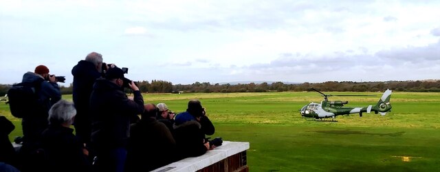
Capturing a Gazelle Three Army Air Corps Gazelles which were performing the fleet retirement flypast sorties around the UK. They stopped to refuel at Manchester Barton Aerodrome. Quite a number of photographers gathered to capture the occasion.
Capturing a Gazelle
Three Army Air Corps Gazelles which were performing the fleet retirement flypast sorties around the UK. They stopped to refuel at Manchester Barton Aerodrome. Quite a number of photographers gathered to capture the occasion.
Irlam Locks on the Manchester Ship Canal
Barton Locks on the Manchester Ship Canal
Irlam Locks Looking south along the Manchester Ship Canal.
Irlam Locks
Looking south along the Manchester Ship Canal.
On the Manchester Ship Canal Looking from the stern of a Mersey ferry heading south on the canal having passed under the power lines seen here.
On the Manchester Ship Canal
Looking from the stern of a Mersey ferry heading south on the canal having passed under the power lines seen here.
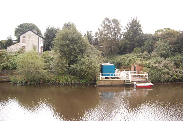
Hulme Bridge Ferry The ferry jetty on the south bank of the Manchester Ship Canal with the disused ferryman's house to the left.
Hulme Bridge Ferry
The ferry jetty on the south bank of the Manchester Ship Canal with the disused ferryman's house to the left.
Hydraulic tower, Barton Locks Taken from a vessel on the Manchester Ship Canal.
Hydraulic tower, Barton Locks
Taken from a vessel on the Manchester Ship Canal.
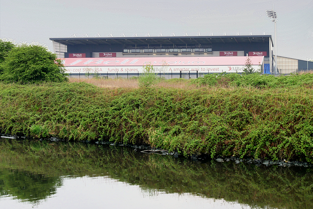
Manchester Ship Canal, AJ Bell Stadium AJ Bell Stadium (formerly the Salford City Stadium) is a rugby stadium at Barton-upon-Irwell, Salford (<span class="nowrap"><a title="http://www.bbc.co.uk/sport/rugby-union/24079365" rel="nofollow ugc noopener" href="http://www.bbc.co.uk/sport/rugby-union/24079365">Link</a><img style="margin-left:2px;" alt="External link" title="External link - shift click to open in new window" src="https://s1.geograph.org.uk/img/external.png" width="10" height="10"/></span>  BBC Sport).  It was built to replace Salford rugby league club's ground The Willows for the 2012 season. Sale Sharks rugby union club have also played at the stadium since the 2012–13 season.
Manchester Ship Canal, AJ Bell Stadium
AJ Bell Stadium (formerly the Salford City Stadium) is a rugby stadium at Barton-upon-Irwell, Salford (LinkExternal link BBC Sport). It was built to replace Salford rugby league club's ground The Willows for the 2012 season. Sale Sharks rugby union club have also played at the stadium since the 2012–13 season.
The AJ Bell Stadium, Salford AJ Bell Stadium (formerly the Salford City Stadium) is a rugby stadium at Barton-upon-Irwell, Salford (<span class="nowrap"><a title="http://www.bbc.co.uk/sport/rugby-union/24079365" rel="nofollow ugc noopener" href="http://www.bbc.co.uk/sport/rugby-union/24079365">Link</a><img style="margin-left:2px;" alt="External link" title="External link - shift click to open in new window" src="https://s1.geograph.org.uk/img/external.png" width="10" height="10"/></span>  BBC Sport).  It was built to replace Salford rugby league club's ground The Willows for the 2012 season. Sale Sharks rugby union club have also played at the stadium since the 2012–13 season.
The AJ Bell Stadium, Salford
AJ Bell Stadium (formerly the Salford City Stadium) is a rugby stadium at Barton-upon-Irwell, Salford (LinkExternal link BBC Sport). It was built to replace Salford rugby league club's ground The Willows for the 2012 season. Sale Sharks rugby union club have also played at the stadium since the 2012–13 season.
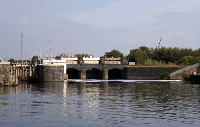
Barton Locks, Manchester Ship Canal Like all the other locks on the Manchester Ship Canal, Barton Locks are built on a foundation of solid sandstone rock with concrete on top. Below the water level the lock walls are built of concrete but are lined above water level with brick and a blue facing brick. There are two locks here, the largest on the north side of the canal measuring 600 x 65 feet to accommodate ocean-going ships, and the smaller one measuring 350 x 45 feet for vessels such as tugs and coasters.

<span class="nowrap"><a title="http://users.breathe.com/g8hxe/barton%20locks.htm" rel="nofollow ugc noopener" href="http://users.breathe.com/g8hxe/barton%20locks.htm">Link</a><img style="margin-left:2px;" alt="External link" title="External link - shift click to open in new window" src="https://s1.geograph.org.uk/img/external.png" width="10" height="10"/></span>
Barton Locks, Manchester Ship Canal
Like all the other locks on the Manchester Ship Canal, Barton Locks are built on a foundation of solid sandstone rock with concrete on top. Below the water level the lock walls are built of concrete but are lined above water level with brick and a blue facing brick. There are two locks here, the largest on the north side of the canal measuring 600 x 65 feet to accommodate ocean-going ships, and the smaller one measuring 350 x 45 feet for vessels such as tugs and coasters. LinkExternal link
Manchester Ship Canal, Barton Locks Like all the other locks on the Manchester Ship Canal, Barton Locks are built on a foundation of solid sandstone rock with concrete on top. Below the water level the lock walls are built of concrete but are lined above water level with brick and a blue facing brick. There are two locks here, the largest on the north side of the canal measuring 600 x 65 feet to accommodate ocean-going ships, and the smaller one measuring 350 x 45 feet for vessels such as tugs and coasters.

<span class="nowrap"><a title="http://users.breathe.com/g8hxe/barton%20locks.htm" rel="nofollow ugc noopener" href="http://users.breathe.com/g8hxe/barton%20locks.htm">Link</a><img style="margin-left:2px;" alt="External link" title="External link - shift click to open in new window" src="https://s1.geograph.org.uk/img/external.png" width="10" height="10"/></span>
Manchester Ship Canal, Barton Locks
Like all the other locks on the Manchester Ship Canal, Barton Locks are built on a foundation of solid sandstone rock with concrete on top. Below the water level the lock walls are built of concrete but are lined above water level with brick and a blue facing brick. There are two locks here, the largest on the north side of the canal measuring 600 x 65 feet to accommodate ocean-going ships, and the smaller one measuring 350 x 45 feet for vessels such as tugs and coasters. LinkExternal link
Barton Locks Control Building Like all the other locks on the Manchester Ship Canal, Barton Locks are built on a foundation of solid sandstone rock with concrete on top. Below the water level the lock walls are built of concrete but are lined above water level with brick and a blue facing brick. There are two locks here, the largest on the north side of the canal measuring 600 x 65 feet to accommodate ocean-going ships, and the smaller one measuring 350 x 45 feet for vessels such as tugs and coasters.

<span class="nowrap"><a title="http://users.breathe.com/g8hxe/barton%20locks.htm" rel="nofollow ugc noopener" href="http://users.breathe.com/g8hxe/barton%20locks.htm">Link</a><img style="margin-left:2px;" alt="External link" title="External link - shift click to open in new window" src="https://s1.geograph.org.uk/img/external.png" width="10" height="10"/></span>
Barton Locks Control Building
Like all the other locks on the Manchester Ship Canal, Barton Locks are built on a foundation of solid sandstone rock with concrete on top. Below the water level the lock walls are built of concrete but are lined above water level with brick and a blue facing brick. There are two locks here, the largest on the north side of the canal measuring 600 x 65 feet to accommodate ocean-going ships, and the smaller one measuring 350 x 45 feet for vessels such as tugs and coasters. LinkExternal link
Show me another place!

Woods End is located at Grid Ref: SJ7395 (Lat: 53.455489, Lng: -2.3933424)

Unitary Authority: Trafford

Police Authority: Greater Manchester

What 3 Words

///unzipped.hires.survey. Near Carrington, Manchester

Nearby Locations

Woods End

Related Wikis

Flixton F.C.

Flixton F.C. was an English football club based in Flixton, near Urmston in Greater Manchester. They played in the North West Counties Football League...

Wellacre Academy

Wellacre Academy (simply referred to as Wellacre and officially Wellacre Technology Academy, formerly Wellacre Technology College and Urmston Wellacre...

Port Salford

Port Salford is a freight terminal on the banks of the Manchester Ship Canal in Barton-upon-Irwell, Greater Manchester, England, 6 miles (9.7 km) west...

Flixton, Greater Manchester

Flixton is a suburb and electoral ward in the Metropolitan Borough of Trafford, Greater Manchester, England. The population of the ward at the 2011 census...

Nearby Amenities

Located within 500m of 53.455489,-2.3933424
Woodsend
Alt Name: Moor Side
Is In: Flixton, Trafford, Greater Manchester, England, UK
Place: suburb
Source: local knowledge
Source Alt Name: npe
Lat/Long: 53.4568998/-2.393673
Source: Landsat
Lat/Long: 53.4589138/-2.3948586
Source: Landsat
Lat/Long: 53.4576391/-2.3968993
Source: Landsat
Lat/Long: 53.4564569/-2.3986858
Source: Landsat
Lat/Long: 53.454867/-2.4006694
Bus Stop
Woodsend Road/Calderbank Avenue
Bus: yes
Naptan AtcoCode: 1800SJ02601
Naptan Bearing: E
Naptan CommonName: Woodsend Road/Calderbank Avenue
Naptan Indicator: O/s House 253
Naptan Landmark: CALDER BANK HSE
Naptan NaptanCode: manjpapd
Naptan PlusbusZoneRef: MNCRPIC
Naptan ShortCommonName: Calderbank Avenue
Naptan Street: WOODSEND ROAD
Naptan Verified: no
Network: TfGM
Public Transport: platform
Route Ref: 15
Shelter: yes
Source: naptan_import
Lat/Long: 53.4578806/-2.3885977
Bus Stop
Woodsend Road/Calderbank Avenue
Bus: yes
Naptan AtcoCode: 1800SJ02611
Naptan Bearing: W
Naptan CommonName: Woodsend Road/Calderbank Avenue
Naptan Indicator: Bungalow
Naptan Landmark: HOUSE 238
Naptan NaptanCode: manjpapg
Naptan PlusbusZoneRef: MNCRPIC
Naptan ShortCommonName: Calderbank Avenue
Naptan Street: WOODSEND ROAD
Naptan Verified: no
Network: TfGM
Public Transport: platform
Route Ref: 15
Source: naptan_import
Lat/Long: 53.457739/-2.3895253
Bus Stop
Woodsend Road/Valley Road
Bus: yes
Naptan AtcoCode: 1800SJ02621
Naptan Bearing: N
Naptan CommonName: Woodsend Road/Valley Road
Naptan Indicator: O/s House 181
Naptan Landmark: HOUSE 181
Naptan NaptanCode: manjpapj
Naptan PlusbusZoneRef: MNCRPIC
Naptan ShortCommonName: Valley Road
Naptan Street: WOODSEND ROAD
Naptan Verified: no
Network: TfGM
Public Transport: platform
Route Ref: 15
Source: naptan_import
Lat/Long: 53.4559583/-2.3935676
Bus Stop
Woodsend Road/Valley Road
Bus: yes
Naptan AtcoCode: 1800SJ02631
Naptan Bearing: S
Naptan CommonName: Woodsend Road/Valley Road
Naptan Indicator: O/s House 156
Naptan Landmark: HOUSE 156
Naptan NaptanCode: manjpapm
Naptan PlusbusZoneRef: MNCRPIC
Naptan ShortCommonName: Valley Road
Naptan Street: WOODSEND ROAD
Naptan Verified: no
Network: TfGM
Public Transport: platform
Route Ref: 15
Source: naptan_import
Lat/Long: 53.4550321/-2.3931091
Bus Stop
Woodsend Road/Woodsend Circle
Bus: yes
Naptan AtcoCode: 1800SJ02641
Naptan Bearing: S
Naptan CommonName: Woodsend Road/Woodsend Circle
Naptan Indicator: Bungalow
Naptan Landmark: LIBRARY
Naptan NaptanCode: manjpapt
Naptan PlusbusZoneRef: MNCRPIC
Naptan ShortCommonName: Woodsend Circle
Naptan Street: WOODSEND ROAD
Naptan Verified: no
Network: TfGM
Note: alighting stop only
Public Transport: platform
Route Ref: Alighting Stop Only
Source: naptan_import
Lat/Long: 53.4533178/-2.3925745
Bus Stop
Woodsend Crescent Rd/Woodsend Circle
Bus: yes
Naptan AtcoCode: 1800SJ02781
Naptan Bearing: SW
Naptan CommonName: Woodsend Crescent Rd/Woodsend Circle
Naptan Indicator: Park
Naptan Landmark: PARK
Naptan NaptanCode: manjpawt
Naptan PlusbusZoneRef: MNCRPIC
Naptan ShortCommonName: Woodsend Circle
Naptan Street: WOODSEND CRES R
Naptan Verified: no
Network: TfGM
Public Transport: platform
Route Ref: 15;290;291
Source: naptan_import
Lat/Long: 53.4521636/-2.3935963
Bus Stop
Woodsend Circle, Moorside Road / adjacent Woodsend Circle
Bus: yes
Naptan AtcoCode: 1800SJ02791
Naptan Bearing: W
Naptan CommonName: Moorside Road/Woodsend Circle
Naptan Indicator: Shops
Naptan Landmark: SHOPS
Naptan NaptanCode: manjpdad
Naptan PlusbusZoneRef: MNCRPIC
Naptan ShortCommonName: Woodsend Circle
Naptan Street: MOORSIDE ROAD
Naptan Verified: no
Network: TfGM
Operator: TfGM
Public Transport: platform
Route Ref: 245;247;256;258;278;290;291;256_NB
Source: naptan_import
Lat/Long: 53.4525965/-2.391846
Bus Stop
Woodsend Circle, Woodsend Circle / near Woodbridge Road
Bus: yes
Naptan AtcoCode: 1800SJ16351
Naptan Bearing: NE
Naptan CommonName: Woodsend Circle/Woodbridge Road
Naptan Indicator: Shopping Plaza
Naptan Landmark: SHOPPING PLAZA
Naptan NaptanCode: manjtdjd
Naptan PlusbusZoneRef: MNCRPIC
Naptan ShortCommonName: Woodbridge Road
Naptan Street: WOODSEND CIRCLE
Naptan Verified: no
Network: TfGM
Operator: TfGM
Public Transport: platform
Route Ref: 15;241;245;247;256;258;278
Shelter: yes
Source: naptan_import
Lat/Long: 53.4526067/-2.3933241
Give Way
Direction: forward
Lat/Long: 53.452237/-2.3928906
Give Way
Direction: forward
Lat/Long: 53.45278/-2.3926363
Turning Circle
Lat/Long: 53.4533353/-2.3871623
Turning Circle
Lat/Long: 53.4563848/-2.3925321
Turning Circle
Lat/Long: 53.455/-2.3912779
Turning Circle
Lat/Long: 53.4560455/-2.3885836
Turning Circle
Lat/Long: 53.4551713/-2.3865436
Turning Circle
Lat/Long: 53.4575111/-2.3875104
Turning Circle
Lat/Long: 53.456828/-2.3962646
Give Way
Direction: forward
Lat/Long: 53.4527996/-2.3930243
Lcn Ref: 228
Lat/Long: 53.458363/-2.3940574
Hall
Woodsend Sport and Community Centre
Lat/Long: 53.4517608/-2.3942106
Recycling
Lat/Long: 53.452401/-2.3940561
A Cut Above
Phone: +44 161 746 7496
Shop: hairdresser
Lat/Long: 53.4521089/-2.3923984
Post Box
Ref: M41 624
Lat/Long: 53.4525205/-2.3923146
Spar
Brand: Spar
Brand Wikidata: Q610492
Brand Wikipedia: en:SPAR (retailer)
Shop: convenience
Lat/Long: 53.4522708/-2.392346
Cafe
One Twenty Two
Addr City: Manchester
Addr Housename: OneTwentyTwo
Addr Housenumber: 122
Addr Postcode: M41 8QZ
Addr Street: Woodsend Road
Internet Access: wlan
Opening Hours: Mo-Fr 08:00-16:00
Outdoor Seating: no
Phone: +44 161 747 0081
Smoking: outside
Website: https://onetwentytwo.co.uk/
Lat/Long: 53.4523846/-2.3923001
High Class Butchers
Phone: +44 161 748 6351
Shop: butcher
Lat/Long: 53.4524362/-2.3920216
Sayers
Shop: bakery
Lat/Long: 53.452451/-2.3915179
Pharmacy
Well Pharmacy
Addr City: Manchester
Addr Housenumber: 475
Addr Postcode: M41 8TW
Addr Street: Moorside Road
Brand: Well Pharmacy
Brand Wikidata: Q7726524
Brand Wikipedia: en:Well Pharmacy
Dispensing: yes
Fhrs Id: 616198
Healthcare: pharmacy
Website: https://finder.well.co.uk/store/flixton-moorside-road
Lat/Long: 53.4524442/-2.3917483
Travers Opticians
Phone: +44 161 746 8098
Shop: optician
Lat/Long: 53.4524464/-2.3916751
Moorside Bottle Shop
Shop: beverages
Lat/Long: 53.4524415/-2.3918416
Restaurant
Shamnah
Cuisine: indian
Phone: +44 161 747 8055
Lat/Long: 53.4524489/-2.3915884
Fast Food
Lucy's Take Away
Lat/Long: 53.4524382/-2.3919511
Post Office
Woodsend Road Post Office
Addr City: Manchester
Addr Country: GB
Addr Postcode: M41 8QZ
Addr Street: Woodsend Road
Brand: Post Office
Brand Wikidata: Q1783168
Contact Website: https://www.postoffice.co.uk/branch-finder/392422x/woodsend-road
Ref Pol Id: 14383
Lat/Long: 53.452442/-2.3921951
Atm
Fee: no
Operator: Post_office
Lat/Long: 53.4524675/-2.3921718
Ian Dewar Interiors
Phone: +44 161 748 3082
Shop: carpet
Lat/Long: 53.452453/-2.3914486
Cutting Rooms
Phone: +44 161 748 4765
Shop: hairdresser
Lat/Long: 53.4524555/-2.3913646
Fast Food
Darbar Balti
Cuisine: indian
Lat/Long: 53.4565692/-2.3938116
Esteem
Shop: hairdresser
Lat/Long: 53.4566139/-2.3938481
Restaurant
Lam's Cottage
Cuisine: chinese
Lat/Long: 53.4566558/-2.3938691
G.S.P. Convenience Store & Off Licence
Shop: convenience
Lat/Long: 53.4567053/-2.3938971
El Roma
Shop: beauty
Lat/Long: 53.4567546/-2.3939156
Toni's Pets Health & Beauty Parlour
Shop: pet_grooming
Lat/Long: 53.4568106/-2.3939482
Power: substation
Ref: 165732
Lat/Long: 53.4570105/-2.3944992
Pub
Fox & Hounds
Lat/Long: 53.4570499/-2.393539
Post Box
Ref: M41 626
Lat/Long: 53.4574579/-2.3924879
Note: underground
Power: substation
Ref: 165737
Lat/Long: 53.4547588/-2.3883077
Power: substation
Ref: 166223
Lat/Long: 53.4573044/-2.388653
Power: tower
Lat/Long: 53.4575337/-2.3958688
Power: tower
Lat/Long: 53.4556036/-2.3988849
Power: tower
Lat/Long: 53.4598287/-2.3923052
Parking
Lat/Long: 53.4550537/-2.3979431
Barrier: yes
Lat/Long: 53.4524157/-2.3943008
Bicycle Parking
Bicycle Parking: stands
Covered: no
Fee: no
Lat/Long: 53.4566675/-2.3936909
Give Way
Direction: forward
Lat/Long: 53.4531324/-2.393538
Give Way
Direction: forward
Lat/Long: 53.4524003/-2.3932929
Give Way
Direction: forward
Lat/Long: 53.452518/-2.3924602
Bicycle Parking
Bicycle Parking: stands
Capacity: 8
Covered: no
Fee: no
Lat/Long: 53.4521129/-2.3926541
Give Way
Direction: forward
Lat/Long: 53.4575962/-2.3999649
Ferry: yes
Public Transport: stop_position
Lat/Long: 53.4593236/-2.3953806
Addr Housenumber: 69
Addr Street: Ullswater Road
Building: house
Building Levels: 2
Building Material: brick
Lat/Long: 53.4553058/-2.3890487
Addr Housenumber: 65
Addr Street: Ullswater Road
Building: house
Building Levels: 2
Building Material: brick
Lat/Long: 53.4551629/-2.3887773
Addr Housenumber: 67
Addr Street: Ullswater Road
Building: house
Building Levels: 2
Building Material: brick
Lat/Long: 53.4552348/-2.3889208
Barrier: bollard
Lat/Long: 53.4539868/-2.396434
The data included in this document is from www.openstreetmap.org. The data is made available under ODbL.

Have you been to Woods End?

Leave your review of Woods End below (or comments, questions and feedback).