Wilton

Settlement in Somerset Somerset West and Taunton

England

Wilton

Service Road behind the main street in Taunton This is the service road behind the main street in Taunton and it also provides access for delivery vehicles to the nearby Morrisons superstore.
Service Road behind the main street in Taunton Credit: Mike Crowe

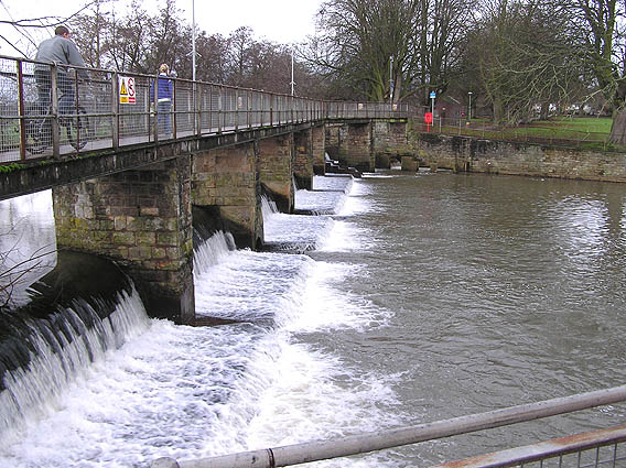
Wilton is a small village located in the county of Somerset, England. Situated approximately 8 miles west of the town of Taunton, it lies on the banks of the River Tone. With a population of around 500 inhabitants, Wilton is a close-knit community known for its picturesque countryside and historic charm.

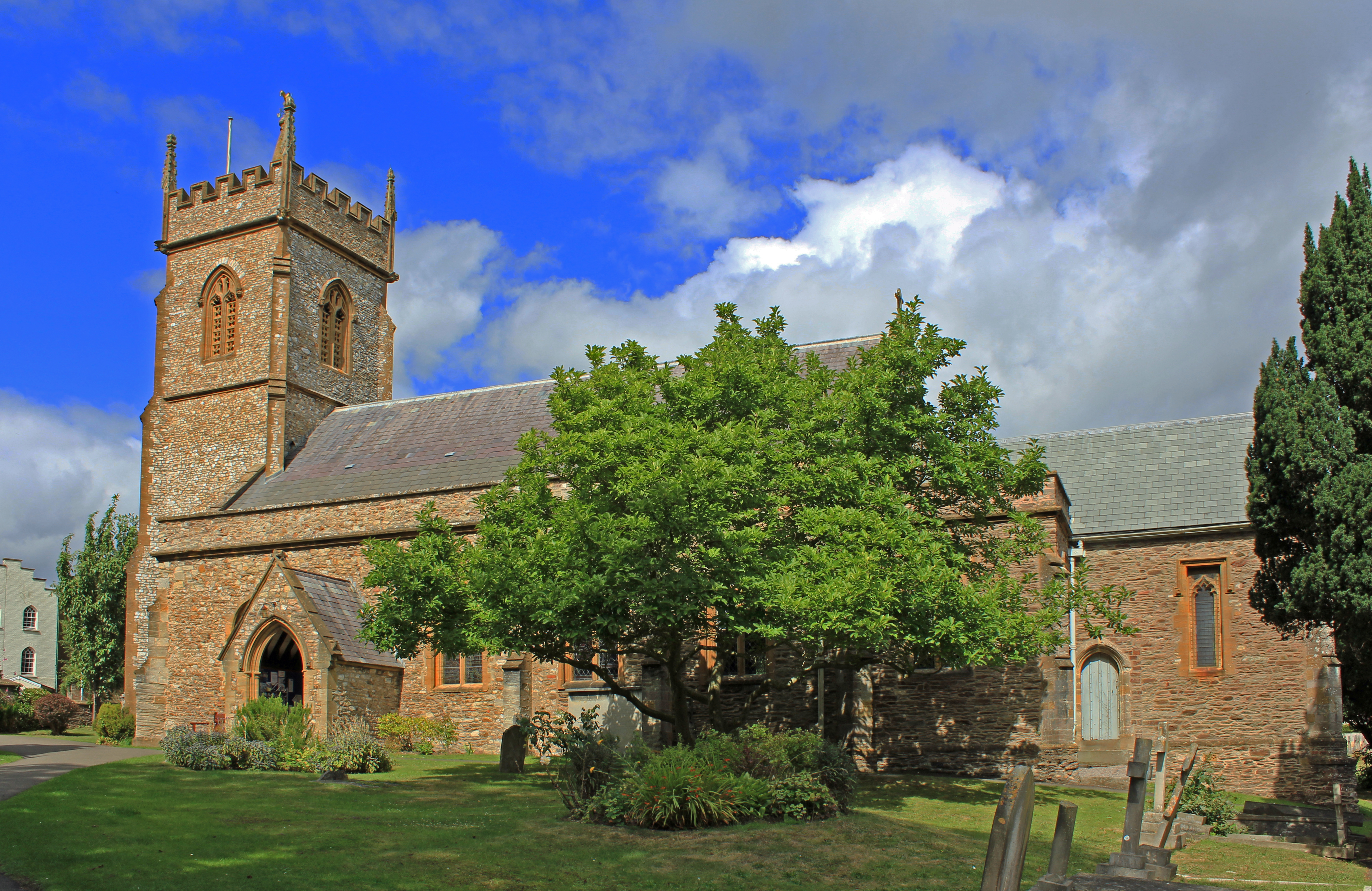
The village is renowned for its rich history, dating back to the medieval period. Its most notable landmark is Wilton Church, a Grade I listed building that dates back to the 13th century. The church's striking architecture and stained glass windows make it a popular attraction for tourists and history enthusiasts alike.

Wilton also boasts a number of traditional thatched cottages, creating a quaint and idyllic atmosphere. The village has a strong agricultural heritage, with the surrounding fields providing a picturesque backdrop of rolling hills and lush greenery.

Despite its small size, Wilton offers a range of amenities for its residents. These include a village pub, a primary school, and a community center that hosts various events throughout the year. The village also benefits from a close proximity to Taunton, where residents have access to a wider range of services and facilities.

Surrounded by beautiful countryside, Wilton is an ideal location for outdoor activities such as walking, cycling, and fishing. The nearby Quantock Hills and Exmoor National Park provide ample opportunities for exploring nature and enjoying stunning views.

In summary, Wilton is a charming and historic village that offers a peaceful and picturesque setting. With its rich heritage and close-knit community, it is a delightful place to live or visit for those seeking a taste of rural Somerset.

If you have any feedback on the listing, please let us know in the comments section below.

Wilton Images

Images are sourced within 2km of 51.00931/-3.1082253 or Grid Reference ST2223. Thanks to Geograph Open Source API. All images are credited.

Service Road behind the main street in Taunton This is the service road behind the main street in Taunton and it also provides access for delivery vehicles to the nearby Morrisons superstore.
Service Road behind the main street in Taunton
This is the service road behind the main street in Taunton and it also provides access for delivery vehicles to the nearby Morrisons superstore.
Swans on the River Tone The view point is the access bridge for the cattle market/auction site which is visible at centre right. Priory Bridge can be seen in the background.
Swans on the River Tone
The view point is the access bridge for the cattle market/auction site which is visible at centre right. Priory Bridge can be seen in the background.
Vivary Park, Taunton This elaborate fountain is in the centre of the park.  The fort-like building in the background is the barracks.
Vivary Park, Taunton
This elaborate fountain is in the centre of the park. The fort-like building in the background is the barracks.
Taunton Carnival Theatreland, the 2005 entry from Harlequins Carnival Club of Ilminster leaves the Priory Bridge Road assembly area during Taunton Carnival procession.
Taunton Carnival
Theatreland, the 2005 entry from Harlequins Carnival Club of Ilminster leaves the Priory Bridge Road assembly area during Taunton Carnival procession.
Taunton Carnival A view over Priory Bridge Road car park, in use as the assembly area for Taunton Carnival 2005. As the skies darken, last minute checks are being made on the floats and the majorettes are preparing to practise their routine.
Taunton Carnival
A view over Priory Bridge Road car park, in use as the assembly area for Taunton Carnival 2005. As the skies darken, last minute checks are being made on the floats and the majorettes are preparing to practise their routine.
Taunton Carnival As the moon rises, a police motor cyclist keeps an eye on some of the carnival floats preparing for the 2005 Taunton Carnival procession.
Taunton Carnival
As the moon rises, a police motor cyclist keeps an eye on some of the carnival floats preparing for the 2005 Taunton Carnival procession.
Taunton Carnival It's rush, rush, rush as start time approaches!  This is a view of some of the carnival floats in the Priory Bridge Road assembly area as they prepare for the 2005 Taunton Carnival procession.
Taunton Carnival
It's rush, rush, rush as start time approaches! This is a view of some of the carnival floats in the Priory Bridge Road assembly area as they prepare for the 2005 Taunton Carnival procession.
Taunton Carnival The 2005 entry form Phoenix Carnival club leaves the assembly area as it starts its journey along the Taunton Carnival procession route.
Taunton Carnival
The 2005 entry form Phoenix Carnival club leaves the assembly area as it starts its journey along the Taunton Carnival procession route.
Taunton Carnival Admiring crowds line the route as the 2005 entry form Gemini Carnival Club starts on its way along the Taunton Carnival procession.  This is a tableau float and the poses will be maintained for the duration of the procession, approximately two hours.
Taunton Carnival
Admiring crowds line the route as the 2005 entry form Gemini Carnival Club starts on its way along the Taunton Carnival procession. This is a tableau float and the poses will be maintained for the duration of the procession, approximately two hours.
Taunton School An independent boarding and day school for boys set in beautiful grounds close to the town centre.
Taunton School
An independent boarding and day school for boys set in beautiful grounds close to the town centre.
The County Ground, Taunton Somerset are playing Hampshire in a four day county fixture. The Ian Botham Stand opposite is named after one of Somerset's most illustrious former players.
The County Ground, Taunton
Somerset are playing Hampshire in a four day county fixture. The Ian Botham Stand opposite is named after one of Somerset's most illustrious former players.
Trull: All Saints Church A 13th century west tower with the body of the church dating from the 15th century. It is noted for its wooden pulpit with carvings depicting five saints
Trull: All Saints Church
A 13th century west tower with the body of the church dating from the 15th century. It is noted for its wooden pulpit with carvings depicting five saints
River Tone Looking down from the footbridge at the riverside path alongside the supermarket car park. A popular spot for feeding swans, ducks and gulls.
River Tone
Looking down from the footbridge at the riverside path alongside the supermarket car park. A popular spot for feeding swans, ducks and gulls.
St. Mary Magdalene, Taunton The parish church of St.Mary Magdalene, Taunton
St. Mary Magdalene, Taunton
The parish church of St.Mary Magdalene, Taunton
Christmas Lights, Taunton A view of the cross at the top of North Street, Taunton, with festive lights in the background.
Christmas Lights, Taunton
A view of the cross at the top of North Street, Taunton, with festive lights in the background.
St. James's church, Taunton
Tudor Inn, Taunton Dates back to the 1600's when Judge Jeffrys of "Bloody Assize" infamy, was believed to have stayed here.
Tudor Inn, Taunton
Dates back to the 1600's when Judge Jeffrys of "Bloody Assize" infamy, was believed to have stayed here.
French Weir, River Tone
Show me another place!

Wilton is located at Grid Ref: ST2223 (Lat: 51.00931, Lng: -3.1082253)

Administrative County: Somerset

District: Somerset West and Taunton

Police Authority: Avon and Somerset

What 3 Words

///bared.photo.atoms. Near Taunton, Somerset

Related Wikis

St George's Church, Fons George

The Church of St George is an Anglican church in Taunton, Somerset, England, which dates from Saxon times. It is the parish church for Wilton, within the...

Taunton Shire Hall

Taunton Shire Hall is a municipal building on Shuttern in Taunton, Somerset. The Shire Hall, which serves as a Crown Court, is a Grade II listed building...

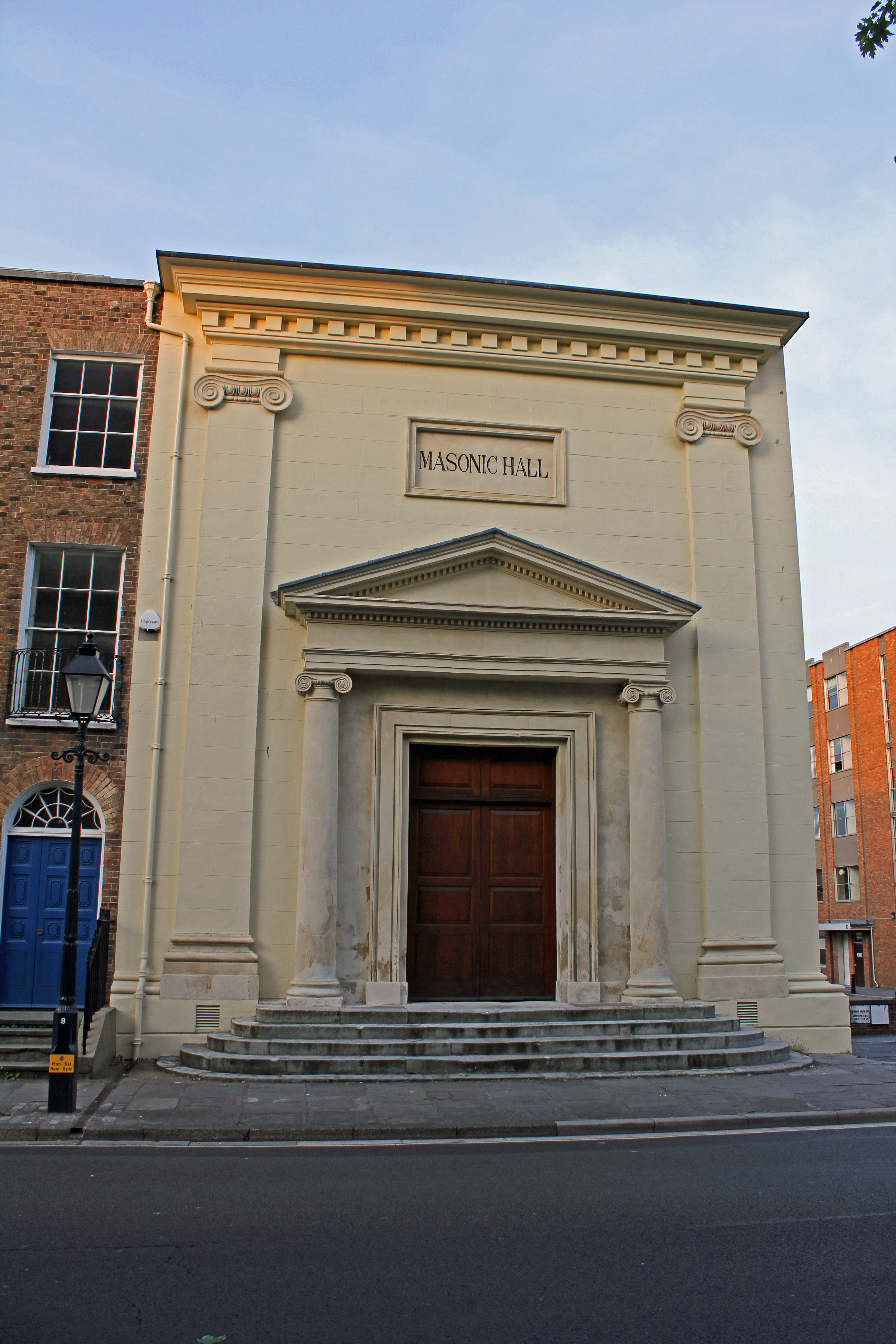
Masonic Hall, Taunton

The Masonic Hall in Taunton, Somerset, is designated by Historic England as a Grade II* listed building. It was originally built in the early 19th century...

The Crescent, Taunton

The Crescent is a street in Taunton, a town in the English county of Somerset. Construction began in 1807, during a period of extensive redevelopment in...

Nearby Amenities

Located within 500m of 51.00931,-3.1082253
Mini Roundabout
Direction: clockwise
Lat/Long: 51.0076162/-3.1117947
Traffic Calming: choker
Lat/Long: 51.0108517/-3.1140519
Give Way
Lat/Long: 51.007707/-3.1096045
Crossing
Button Operated: yes
Crossing: traffic_signals
Crossing Island: no
Crossing Ref: pelican
Source: bing
Tactile Paving: yes
Traffic Signals Sound: yes
Lat/Long: 51.0119972/-3.1033182
Mini Roundabout
Direction: clockwise
Lat/Long: 51.01314/-3.1049192
Speed Camera
Maxspeed: 30 mph
Lat/Long: 51.0132989/-3.1111645
Wilton
Is In: Taunton
Place: suburb
Lat/Long: 51.0088677/-3.1055951
Barrier: cycle_barrier
Bicycle: yes
Foot: yes
Lat/Long: 51.0115599/-3.104935
Turning Circle
Lat/Long: 51.0113912/-3.1119207
Give Way
Lat/Long: 51.0059058/-3.1081106
Barrier: bollard
Bicycle: yes
Foot: yes
Lat/Long: 51.0055591/-3.1053238
Barrier: bollard
Bicycle: yes
Foot: yes
Lat/Long: 51.0053166/-3.1063578
Barrier: bollard
Bicycle: yes
Foot: yes
Lat/Long: 51.0058475/-3.1053167
Crossing
Crossing: traffic_signals
Crossing Ref: pelican
Lat/Long: 51.0119264/-3.1062587
Addr City: Taunton
Addr Housename: County Hall
Addr Postcode: TA1 4DY
Door: automatic
Entrance: yes
Level: 0
Wheelchair: yes
Lat/Long: 51.01341/-3.106775
Barrier: lift_gate
Lat/Long: 51.012485/-3.1072301
Give Way
Lat/Long: 51.0063773/-3.1083512
Give Way
Lat/Long: 51.0110096/-3.1138603
Crossing
Crossing: uncontrolled
Crossing Ref: zebra
Lat/Long: 51.0111158/-3.1138492
Give Way
Lat/Long: 51.0106529/-3.1115769
Traffic Calming: choker
Lat/Long: 51.0115601/-3.1136781
Give Way
Lat/Long: 51.0084298/-3.1107599
Give Way
Direction: forward
Lat/Long: 51.0133599/-3.1088517
Give Way
Direction: forward
Lat/Long: 51.0131202/-3.1086592
Give Way
Source: bing
Lat/Long: 51.0121013/-3.1027326
Check Date: 2024-04-11
Information: board
Tourism: information
Lat/Long: 51.0117329/-3.1029219
Bbq
Lat/Long: 51.0107592/-3.1031823
Bench
Lat/Long: 51.0104521/-3.1039655
Bench
Lat/Long: 51.0089563/-3.1058483
Give Way
Lat/Long: 51.0118624/-3.1134461
Give Way
Lat/Long: 51.0116009/-3.1100578
Give Way
Lat/Long: 51.0105952/-3.1106932
Give Way
Lat/Long: 51.0106094/-3.1116895
Give Way
Lat/Long: 51.0105103/-3.1143657
Give Way
Lat/Long: 51.0084101/-3.109607
Give Way
Lat/Long: 51.008455/-3.1096194
Give Way
Lat/Long: 51.0084646/-3.1083437
Give Way
Lat/Long: 51.0079871/-3.1072776
Give Way
Lat/Long: 51.0081417/-3.1082772
Give Way
Lat/Long: 51.0103828/-3.1147003
Give Way
Lat/Long: 51.0122685/-3.1095153
Give Way
Direction: forward
Lat/Long: 51.0131474/-3.110552
Barrier: bollard
Bicycle: yes
Foot: yes
Lat/Long: 51.0056649/-3.1063642
Give Way
Lat/Long: 51.0110212/-3.1087311
Give Way
Lat/Long: 51.0114311/-3.1081241
Give Way
Lat/Long: 51.0122326/-3.107722
Give Way
Lat/Long: 51.0107353/-3.1086045
Give Way
Lat/Long: 51.011707/-3.1054268
Access: permissive
Barrier: lift_gate
Bicycle: no
Foot: yes
Motorcar: yes
Motorcycle: yes
Lat/Long: 51.0122136/-3.1053119
Give Way
Lat/Long: 51.0129517/-3.1056847
Bus Stop
County Hall (SW-bound)
Bus: yes
Direction: 240
Naptan AtcoCode: 3600SOA10040
Naptan Bearing: SW
Naptan CommonName: County Hall
Naptan Indicator: SW-bound
Naptan NaptanCode: sotajdat
Naptan PlusbusZoneRef: TAUNTON
Naptan Street: Park Street
Naptan Verified: no
Network: The Buses of Somerset
Network Wikidata: Q17018973
Operator: First South West
Operator Wikidata: Q5454172
Public Transport: platform
Ref: P&R;3;7;22;22A;X22;101
Shelter: yes
Lat/Long: 51.0135524/-3.1075769
Bus Stop
County Hall (NE-bound)
Bus: yes
Direction: 65
Naptan AtcoCode: 3600SOA30070
Naptan Bearing: NE
Naptan CommonName: County Hall
Naptan Indicator: NE-bound
Naptan NaptanCode: sotajdap
Naptan PlusbusZoneRef: TAUNTON
Naptan Street: Park Street
Naptan Verified: no
Network: The Buses of Somerset
Network Wikidata: Q17018973
Operator: First South West
Operator Wikidata: Q5454172
Public Transport: platform
Ref: P&R;3;7;22;22A;X22;101
Shelter: yes
Lat/Long: 51.0136114/-3.1077245
Barrier: bollard
Bicycle: yes
Foot: yes
Lat/Long: 51.0119599/-3.1030986
Barrier: bollard
Bicycle: yes
Foot: yes
Lat/Long: 51.0119646/-3.1030771
Barrier: bollard
Bicycle: yes
Foot: yes
Lat/Long: 51.0119708/-3.103052
Barrier: bollard
Bicycle: yes
Foot: yes
Lat/Long: 51.0119747/-3.1030321
Post Box
Operator: Royal Mail
Operator Wikidata: Q638098
Post Box Type: pillar
Ref: TA1 333
Lat/Long: 51.0118157/-3.1061851
Web Development Today
Addr City: Taunton
Addr Housenumber: 2
Addr Postcode: TA1 4ES
Addr Street: Westbourne Terrace
Opening Hours: Mo-Fr 08:30-17:00, Sa 10:00-16:00
Phone: +44 7480 333272
Website: https://www.webdevelopment.today
Lat/Long: 51.0121629/-3.1079484
Addr City: Taunton
Addr Housename: Brendon House
Addr Housenumber: 36
Addr Postcode: TA1 3RL
Addr Street: High Street
Note: There's a second postcode for Brendon House.
Lat/Long: 51.0121697/-3.1043555
Bus Stop
Barton Close
Bus: yes
Direction: 40
Naptan AtcoCode: 3600SOC30932
Naptan Bearing: NE
Naptan CommonName: Barton Close
Naptan Indicator: NE-bound
Naptan NaptanCode: sotajagd
Naptan PlusbusZoneRef: TAUNTON
Naptan Street: Parkfield Road
Naptan Verified: no
Network: The Buses of Somerset
Network Wikidata: Q17018973
Operator: First South West
Operator Wikidata: Q5454172
Public Transport: platform
Ref: 7
Lat/Long: 51.0102851/-3.1149096
Bus Stop
Barton Close
Bus: yes
Direction: 220
Naptan AtcoCode: 3600SOC30931
Naptan NaptanCode: sotajagj
Network: The Buses of Somerset
Network Wikidata: Q17018973
Operator: First South West
Operator Wikidata: Q5454172
Public Transport: platform
Ref: 7
Lat/Long: 51.0102339/-3.1147875
Outdoor children's playground next to the coffee station
Leisure: indoor_play
Lat/Long: 51.0097594/-3.1034368
Events Venue
Cricket ground
Lat/Long: 51.0100348/-3.10305
The data included in this document is from www.openstreetmap.org. The data is made available under ODbL.

Have you been to Wilton?

Leave your review of Wilton below (or comments, questions and feedback).