Whittingham

Settlement in Northumberland

England

Whittingham

St Bart's Church, Whittingham Grade 1 Listed <span class="nowrap"><a title="https://historicengland.org.uk/listing/the-list/list-entry/1041257" rel="nofollow ugc noopener" href="https://historicengland.org.uk/listing/the-list/list-entry/1041257">Link</a><img style="margin-left:2px;" alt="External link" title="External link - shift click to open in new window" src="https://s1.geograph.org.uk/img/external.png" width="10" height="10"/></span>
St Bart's Church, Whittingham Credit: Brian Deegan

Whittingham is a small village located in the county of Northumberland, England. Situated in the northeast of the country, it lies approximately 10 miles northwest of Alnwick and 13 miles south of Alnwick Moor. With a population of around 300 residents, this rural community offers a peaceful and picturesque setting.

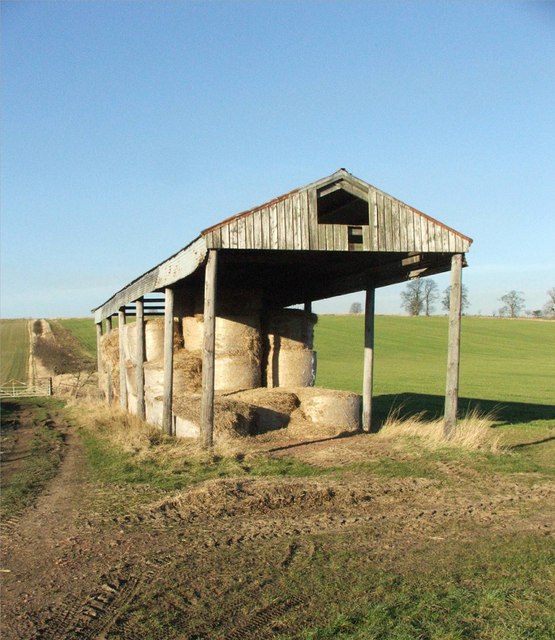
The village is nestled amidst rolling hills and lush green countryside, making it an ideal destination for those seeking tranquility and natural beauty. Whittingham is surrounded by farmland, providing a glimpse into the region's agricultural heritage. The nearby River Aln adds to the village's charm, offering scenic riverside walks and opportunities for fishing.

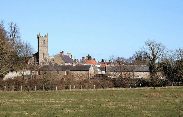
Whittingham is home to a number of traditional stone-built houses, some of which date back to the 18th century. The village also boasts a quaint church, St. Bartholomew's, which has stood at the heart of the community for centuries.

Despite its small size, Whittingham offers a range of amenities for its residents and visitors. These include a village hall where community events are held, a primary school, and a local pub where locals and tourists can socialize and enjoy a pint.

For those interested in exploring the wider area, Whittingham is conveniently located near several popular attractions. Alnwick Castle, famous for its appearances in films such as Harry Potter, is a short drive away. The Northumberland National Park and the stunning coastline are also within easy reach, offering opportunities for outdoor activities and scenic exploration.

Overall, Whittingham provides a charming and idyllic retreat for those seeking a peaceful village setting amidst the natural beauty of Northumberland.

If you have any feedback on the listing, please let us know in the comments section below.

Whittingham Images

Images are sourced within 2km of 55.401925/-1.891941 or Grid Reference NU0612. Thanks to Geograph Open Source API. All images are credited.

St Bart's Church, Whittingham Grade 1 Listed <span class="nowrap"><a title="https://historicengland.org.uk/listing/the-list/list-entry/1041257" rel="nofollow ugc noopener" href="https://historicengland.org.uk/listing/the-list/list-entry/1041257">Link</a><img style="margin-left:2px;" alt="External link" title="External link - shift click to open in new window" src="https://s1.geograph.org.uk/img/external.png" width="10" height="10"/></span>
St Bart's Church, Whittingham
Grade 1 Listed LinkExternal link
Fountain Memorial, Whittingham The base reads 

TO THE DEAR MEMORY
OF
ATHOLE
THIRD EARL OF
RAVENSWORTH

HE SHALL FEED ME IN A
GREEN PASTURE AND LEAD
ME FORTH BESIDE THE
WATERS OF COMFORT
PS X111.11

ERECTED
BY HIS WIFE
CAROLINE
COUNTESS OF
RAVENSWORTH

THE LORD IS MY SHEPHERD
I SHALL NOT WANT
PS. XX111.1
Fountain Memorial, Whittingham
The base reads TO THE DEAR MEMORY OF ATHOLE THIRD EARL OF RAVENSWORTH HE SHALL FEED ME IN A GREEN PASTURE AND LEAD ME FORTH BESIDE THE WATERS OF COMFORT PS X111.11 ERECTED BY HIS WIFE CAROLINE COUNTESS OF RAVENSWORTH THE LORD IS MY SHEPHERD I SHALL NOT WANT PS. XX111.1
Thrunton Wood, Northumberland Looking north-northwest over farmland from the northern edge of Thrunton Wood.
Thrunton Wood, Northumberland
Looking north-northwest over farmland from the northern edge of Thrunton Wood.
The Grange, Whittingham
House by the entrance to "The Grange", Whittingham
Road sign at Howbalk farm
The house at Mountain
Season of mists and mellow fruitfulness Autumn 2022 seems to have been an excellent an excellent season for fruits and berries.
Season of mists and mellow fruitfulness
Autumn 2022 seems to have been an excellent an excellent season for fruits and berries.
Ford and footbridge over the River Aln West of Whittingham, where the Aln is a very minor stream at this time of year.
Ford and footbridge over the River Aln
West of Whittingham, where the Aln is a very minor stream at this time of year.
Minor road junction west of Whittingham
Bridge over the River Aln west of Whittingham
Entering Whittingham and passing St Bartholomew's Church
Tram lines Tractor tracks in winter cereals near Whittingham.
Tram lines
Tractor tracks in winter cereals near Whittingham.
Track near Whittingham Bound for Thrunton Wood.
Track near Whittingham
Bound for Thrunton Wood.
Rothill An old farm building that would, no doubt, make a fantastic house amidst the wonderful countryside of Northumberland.
Rothill
An old farm building that would, no doubt, make a fantastic house amidst the wonderful countryside of Northumberland.
Rothill Farm The mechanics of a working farm in Northumberland
Rothill Farm
The mechanics of a working farm in Northumberland
Barn Near the Devil's Causeway - Northumberland
Barn
Near the Devil's Causeway - Northumberland
Cyclists Road from Glanton to Whittingham with the church in the distance.
Cyclists
Road from Glanton to Whittingham with the church in the distance.
Show me another place!

Whittingham is located at Grid Ref: NU0612 (Lat: 55.401925, Lng: -1.891941)

Unitary Authority: Northumberland

Police Authority: Northumbria

What 3 Words

///meatballs.vocal.diver. Near Whittingham, Northumberland

Nearby Locations

Whittingham

Related Wikis

Whittingham, Northumberland

Whittingham is a village and civil parish in Northumberland, England. It is situated on the banks of the River Aln, roughly 4.5 miles (7 km) east of its...

Whittingham railway station (Northumberland)

Whittingham railway station served the village of Whittingham, Northumberland, England from 1887 to 1953 on the Cornhill Branch. == History == The station...

Glanton

Glanton is a small rural village, in the county of Northumberland, England. Agriculture dominates the surrounding area. == Governance == Glanton is in...

Callaly Castle

Callaly Castle is a Grade I listed building and a substantial country house to the north of the village of Callaly, which is some 14.5 km (9.0 mi) to the...

Nearby Amenities

Located within 500m of 55.401925,-1.891941
Whittingham
Place: village
Wikidata: Q4338665
Wikipedia: en:Whittingham, Northumberland
Lat/Long: 55.4019438/-1.8916966
Havanna Inn
Created By: Potlatch 0.10f
Place: locality
Lat/Long: 55.4010336/-1.8889223
Power: pole
Lat/Long: 55.3997348/-1.8898978
Power: pole
Lat/Long: 55.3999931/-1.891327
Power: pole
Lat/Long: 55.4003811/-1.8885337
Power: pole
Lat/Long: 55.4010765/-1.8870671
Power: pole
Lat/Long: 55.4017937/-1.8855961
Power: pole
Lat/Long: 55.4026646/-1.8847873
Power: pole
Lat/Long: 55.4027184/-1.884745
Power: pole
Lat/Long: 55.4030274/-1.8867659
Power: pole
Lat/Long: 55.4031673/-1.8887208
Telephone
Booth: K6
Covered: booth
Lat/Long: 55.4007087/-1.8903718
statue of the 3rd Earl of Ravensworth
Description: Statue erected in 1905
Historic: monument
Wikidata: Q26652615
Lat/Long: 55.4008218/-1.8899939
Post Box
Post Box Design: type_m
Post Box Type: lamp
Ref: NE66 78
Lat/Long: 55.4007118/-1.8903326
Historic: memorial
Lat/Long: 55.40067/-1.8911918
Waste Basket
Lat/Long: 55.4007115/-1.8902818
Bus Stop
Naptan AtcoCode: 3100U070119
Naptan NaptanCode: nldajgpt
Shelter: yes
Lat/Long: 55.400896/-1.8898122
Bench
Backrest: yes
Lat/Long: 55.4008545/-1.8897227
Direction: SSE
Generator Method: photovoltaic
Generator Output Electricity: yes
Generator Solar Modules: 8
Generator Source: solar
Generator Type: solar_photovoltaic_panel
Location: roof
Power: generator
Lat/Long: 55.399687/-1.8945418
Direction: 140
Generator Method: photovoltaic
Generator Output Electricity: yes
Generator Solar Modules: 10
Generator Source: solar
Generator Type: solar_photovoltaic_panel
Location: roof
Power: generator
Lat/Long: 55.4001496/-1.89199
Direction: S
Generator Method: photovoltaic
Generator Output Electricity: yes
Generator Solar Modules: 20
Generator Source: solar
Generator Type: solar_photovoltaic_panel
Location: roof
Power: generator
Lat/Long: 55.4002842/-1.8896558
Direction: 165
Generator Method: photovoltaic
Generator Output Electricity: yes
Generator Solar Modules: 16
Generator Source: solar
Generator Type: solar_photovoltaic_panel
Location: roof
Power: generator
Lat/Long: 55.4016871/-1.8897423
Direction: 145
Generator Method: photovoltaic
Generator Output Electricity: yes
Generator Solar Modules: 8
Generator Source: solar
Generator Type: solar_photovoltaic_panel
Location: roof
Power: generator
Lat/Long: 55.402537/-1.8916561
Direction: 145
Generator Method: photovoltaic
Generator Output Electricity: yes
Generator Solar Modules: 8
Generator Source: solar
Generator Type: solar_photovoltaic_panel
Location: roof
Power: generator
Lat/Long: 55.4025682/-1.8915709
Direction: 145
Generator Method: photovoltaic
Generator Output Electricity: yes
Generator Solar Modules: 16
Generator Source: solar
Generator Type: solar_photovoltaic_panel
Location: roof
Power: generator
Lat/Long: 55.4026405/-1.8914402
Direction: 235
Generator Method: photovoltaic
Generator Output Electricity: yes
Generator Solar Modules: 8
Generator Source: solar
Generator Type: solar_photovoltaic_panel
Location: roof
Power: generator
Lat/Long: 55.4025494/-1.8912541
Direction: 235
Generator Method: photovoltaic
Generator Output Electricity: yes
Generator Solar Modules: 8
Generator Source: solar
Generator Type: solar_photovoltaic_panel
Location: roof
Power: generator
Lat/Long: 55.4025998/-1.8913074
Direction: 175
Generator Method: photovoltaic
Generator Output Electricity: yes
Generator Solar Modules: 16
Generator Source: solar
Generator Type: solar_photovoltaic_panel
Location: roof
Power: generator
Lat/Long: 55.4008779/-1.8981762
Direction: 170
Generator Method: photovoltaic
Generator Output Electricity: yes
Generator Solar Modules: 10
Generator Source: solar
Generator Type: solar_photovoltaic_panel
Location: roof
Power: generator
Lat/Long: 55.4015227/-1.8953897
Advertising: board
Lat/Long: 55.4007134/-1.8903073
Give Way
Direction: forward
Lat/Long: 55.4021612/-1.8918154
Give Way
Direction: backward
Lat/Long: 55.4018832/-1.8919276
Give Way
Direction: forward
Lat/Long: 55.4018391/-1.8914794
The data included in this document is from www.openstreetmap.org. The data is made available under ODbL.

Have you been to Whittingham?

Leave your review of Whittingham below (or comments, questions and feedback).