Whitson

Settlement in Monmouthshire

Wales

Whitson

Signposts at junction of byway and Goldcliff Road The sign on the left says, 'Redwick 5km'; the right hand post has a bridle path sign. The Wales Coast Path comes along the road and turns right on to the byway.
Signposts at junction of byway and Goldcliff Road Credit: M J Roscoe

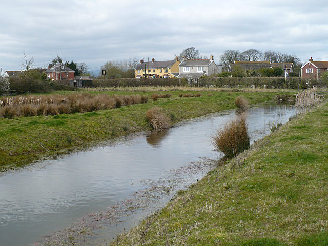
Whitson is a small village located in Monmouthshire, Wales. Situated on the banks of the River Usk, it is surrounded by picturesque countryside and offers a tranquil and scenic setting. The village is approximately 4 miles south of the town of Chepstow and has a population of around 500 residents.

Whitson is known for its rich history, with evidence of human settlement dating back to the Bronze Age. The area was later inhabited by the Romans, who established a fort nearby. Today, remnants of these ancient civilizations can still be seen in the form of archaeological sites and ruins.

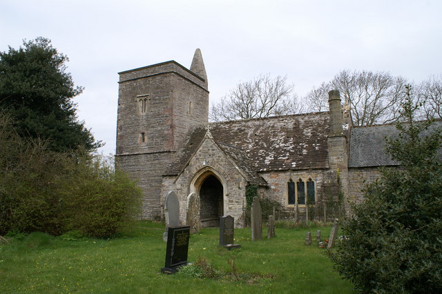
The village itself is characterized by a charming mix of traditional Welsh architecture, with stone houses and cottages lining the narrow streets. The local community is tight-knit, and the village has a strong sense of community spirit. Residents can enjoy a range of amenities, including a village hall, a primary school, and a local pub.

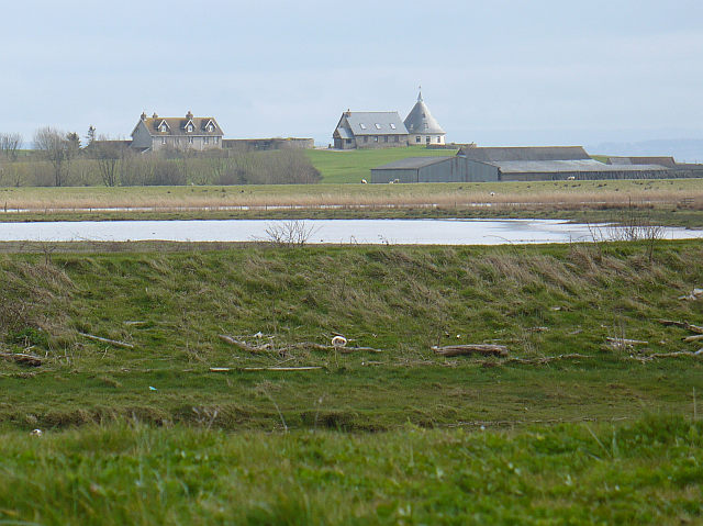
Nature lovers will appreciate the natural beauty surrounding Whitson. The village is nestled in the heart of the Monmouthshire countryside, offering ample opportunities for outdoor activities such as hiking, cycling, and fishing. The nearby River Usk is particularly popular for fishing enthusiasts.

Overall, Whitson is a delightful village that offers a peaceful and idyllic lifestyle. Its rich history, beautiful surroundings, and close-knit community make it a desirable place to live or visit for those seeking a slice of rural Welsh life.

If you have any feedback on the listing, please let us know in the comments section below.

Whitson Images

Images are sourced within 2km of 51.548347/-2.897584 or Grid Reference ST3783. Thanks to Geograph Open Source API. All images are credited.

Signposts at junction of byway and Goldcliff Road The sign on the left says, 'Redwick 5km'; the right hand post has a bridle path sign. The Wales Coast Path comes along the road and turns right on to the byway.
Signposts at junction of byway and Goldcliff Road
The sign on the left says, 'Redwick 5km'; the right hand post has a bridle path sign. The Wales Coast Path comes along the road and turns right on to the byway.
Monks' Ditch above sluice, Level Common Viewed from Wales Coast Path.
Monks' Ditch above sluice, Level Common
Viewed from Wales Coast Path.
Gates on track, Newport Wetlands NNR The Wales Coast Path goes through the wooden gate into the field of mown grass.
Gates on track, Newport Wetlands NNR
The Wales Coast Path goes through the wooden gate into the field of mown grass.
Greenshank Hide, Newport Wetlands NNR Hide on embankment overlooking Monks Lagoon, Goldcliff. For an earlier similar view without the bushes - <a href="https://www.geograph.org.uk/photo/3516019">ST3682 : Bird hide, Goldcliff Lagoons</a>.
Greenshank Hide, Newport Wetlands NNR
Hide on embankment overlooking Monks Lagoon, Goldcliff. For an earlier similar view without the bushes - ST3682 : Bird hide, Goldcliff Lagoons.
Monks Lagoon, Goldcliff, Newport Wetlands NNR Northernmost part of saltwater lagoon viewed from hide <a href="https://www.geograph.org.uk/photo/6947089">ST3682 : Greenshank Hide, Newport Wetlands NNR</a>.
Monks Lagoon, Goldcliff, Newport Wetlands NNR
Northernmost part of saltwater lagoon viewed from hide ST3682 : Greenshank Hide, Newport Wetlands NNR.
Mireland Pill Reen, Goldcliff Drain above sluice; on the skyline is a hide on an embankment
Mireland Pill Reen, Goldcliff
Drain above sluice; on the skyline is a hide on an embankment
Canada geese on Monks Lagoon, Goldcliff Part of island in saltwater lagoon viewed from hide <a href="https://www.geograph.org.uk/photo/6949254">ST3782 : Curlew Hide, Goldcliff Lagoons</a>.
Canada geese on Monks Lagoon, Goldcliff
Part of island in saltwater lagoon viewed from hide ST3782 : Curlew Hide, Goldcliff Lagoons.
Curlew Hide, Goldcliff Lagoons A wooden ramp leads to the hide on an embankment.
Curlew Hide, Goldcliff Lagoons
A wooden ramp leads to the hide on an embankment.
Track over drain in to field The Wales Coast Path goes through the gateway and turns right on a track in to the mown field. The line of trees is by Seawall Road.
Track over drain in to field
The Wales Coast Path goes through the gateway and turns right on a track in to the mown field. The line of trees is by Seawall Road.
Grass track by reen The track carries the Wales Coast Path.
Grass track by reen
The track carries the Wales Coast Path.
Track through gateway in to mown field The Wales Coast Path follows the track alongside the edge of the field to Seawall Road. The line of trees are on the roadside.
Track through gateway in to mown field
The Wales Coast Path follows the track alongside the edge of the field to Seawall Road. The line of trees are on the roadside.
Reen by grass track to Seawall Road The Wales Coast Path is on the track. The buildings are on the far side of the road.
Reen by grass track to Seawall Road
The Wales Coast Path is on the track. The buildings are on the far side of the road.
Gates from field to Seawall Road The Wales Coast path goes through the kissing gate and turns right on to the road. The distant sea wall goes across the picture.
Gates from field to Seawall Road
The Wales Coast path goes through the kissing gate and turns right on to the road. The distant sea wall goes across the picture.
Kissing gate on sea wall The Wales Coast Path comes up steps from the end of Seawall Road and turns right on to the sea wall.
Kissing gate on sea wall
The Wales Coast Path comes up steps from the end of Seawall Road and turns right on to the sea wall.
Hill Fishery and sea wall House and grounds at Goldcliff Point at low water.
Hill Fishery and sea wall
House and grounds at Goldcliff Point at low water.
Remains of putcher ranks on foreshore Row of wooden stakes used to support putchers for trapping salmon.
Remains of putcher ranks on foreshore
Row of wooden stakes used to support putchers for trapping salmon.
Archaeologists working on foreshore, Gold Cliff Archaeologists at extreme low water investigating the remains of a Mesolithic forest. The sparse remains of a putcher rank are at the left.
Archaeologists working on foreshore, Gold Cliff
Archaeologists at extreme low water investigating the remains of a Mesolithic forest. The sparse remains of a putcher rank are at the left.
Lawn at Gold Cliff Point Flagpole and dragon on the edge of the cliff in grounds of house <a href="https://www.geograph.org.uk/photo/6950338">ST3781 : Hill Fishery and sea wall</a>.
Lawn at Gold Cliff Point
Flagpole and dragon on the edge of the cliff in grounds of house ST3781 : Hill Fishery and sea wall.
Show me another place!

Whitson is located at Grid Ref: ST3783 (Lat: 51.548347, Lng: -2.897584)

Unitary Authority: Newport

Police Authority: Gwent

What 3 Words

///outsiders.props.ringside. Near Goldcliff, Newport

Nearby Locations

Goldcliff Whitson

Related Wikis

Whitson

Whitson is a village on the outskirts of the city of Newport, South Wales. It is located about 7 miles (11 km) south east of Newport city centre on the...

Llanwern (electoral ward)

Llanwern is the name of an electoral ward for Newport City Council in south Wales. It covers several rural communities to the east of the city. It is represented...

Goldcliff, Newport

Goldcliff (Welsh: Allteuryn) is a village, parish and community to the south east of the city of Newport in South Wales. It lies within the Newport city...

Goldcliff Priory

Goldcliff Priory was a Benedictine monastery in Goldcliff, Newport, South Wales. It was established in 1113 by Robert de Chandos as a subsidiary house...

Nearby Amenities

Located within 500m of 51.548347,-2.897584
Whitson
Created By: POI Editor
Source: npe
Lat/Long: 51.5465604/-2.8949923
Whitson
Is In City: Newport
Is In Historic County: Monmouthshire
Place: village
Wikidata: Q7996795
Lat/Long: 51.5484689/-2.8972303
Upfield Farm Airstrip
Addr City: Whitson
Aeroway: airstrip
Lat/Long: 51.5516031/-2.8954717
Direction: SSE
Generator Method: photovoltaic
Generator Output Electricity: yes
Generator Solar Modules: 14
Generator Source: solar
Generator Type: solar_photovoltaic_panel
Location: roof
Power: generator
Lat/Long: 51.5457863/-2.896091
Direction: 255
Generator Method: photovoltaic
Generator Output Electricity: yes
Generator Solar Modules: 7
Generator Source: solar
Generator Type: solar_photovoltaic_panel
Location: roof
Power: generator
Lat/Long: 51.5455686/-2.8949102
Direction: 165
Generator Method: photovoltaic
Generator Output Electricity: yes
Generator Solar Modules: 9
Generator Source: solar
Generator Type: solar_photovoltaic_panel
Location: roof
Power: generator
Lat/Long: 51.5455619/-2.8948418
Direction: SW
Generator Method: photovoltaic
Generator Output Electricity: yes
Generator Solar Modules: 18
Generator Source: solar
Generator Type: solar_photovoltaic_panel
Location: roof
Power: generator
Lat/Long: 51.5507584/-2.9016674
Direction: 235
Generator Method: photovoltaic
Generator Output Electricity: yes
Generator Solar Modules: 8
Generator Source: solar
Generator Type: solar_photovoltaic_panel
Location: roof
Power: generator
Lat/Long: 51.5502455/-2.9006857
Direction: SW
Generator Method: photovoltaic
Generator Output Electricity: yes
Generator Solar Modules: 10
Generator Source: solar
Generator Type: solar_photovoltaic_panel
Location: roof
Power: generator
Lat/Long: 51.5503056/-2.9009016
The data included in this document is from www.openstreetmap.org. The data is made available under ODbL.

Have you been to Whitson?

Leave your review of Whitson below (or comments, questions and feedback).