Westborough
Settlement in Yorkshire
England
Westborough

Located in the county of Yorkshire in England, Westborough is a small village that exudes charm and tranquility. Situated approximately 8 miles southwest of the bustling city of York, Westborough offers a peaceful retreat from the urban landscape. The village is nestled amidst picturesque countryside, with rolling hills and verdant fields that create a scenic backdrop.
Westborough boasts a rich history, dating back to the medieval era. The village's name originates from Old English, meaning "west fortified place." This suggests that Westborough was once a fortified settlement, highlighting its strategic importance in the region's past.
The village is characterized by its traditional architecture, with many charming stone cottages and historical buildings still standing. The local church, St. Mary's, is a prominent feature of Westborough, dating back to the 12th century. Its stunning Norman architecture and beautiful stained glass windows make it a must-visit for history enthusiasts and architecture lovers.
While Westborough may be small in size, it offers a close-knit and welcoming community. The village has a local pub, The Rose and Crown, where residents and visitors can enjoy a pint of Yorkshire ale and savor delicious traditional pub meals. Additionally, the surrounding countryside provides ample opportunities for outdoor activities such as hiking, cycling, and horseback riding.
Overall, Westborough is a hidden gem in Yorkshire, offering a peaceful and idyllic escape from the hustle and bustle of modern life. Its rich history, stunning architecture, and beautiful natural surroundings make it a delightful place to visit for those seeking a taste of traditional English village life.
If you have any feedback on the listing, please let us know in the comments section below.
Westborough Images
Images are sourced within 2km of 53.696768/-1.6483175 or Grid Reference SE2322. Thanks to Geograph Open Source API. All images are credited.


Westborough is located at Grid Ref: SE2322 (Lat: 53.696768, Lng: -1.6483175)
Division: West Riding
Unitary Authority: Kirklees
Police Authority: West Yorkshire
What 3 Words
///bronze.ranges.start. Near Batley, West Yorkshire
Nearby Locations
Related Wikis
St John Fisher Catholic Voluntary Academy
St John Fisher Catholic Voluntary Academy (formerly St John Fisher Catholic High School) is a Roman Catholic Mixed Comprehensive in Dewsbury, West Yorkshire...
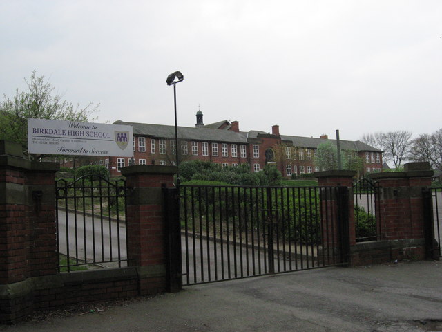
Birkdale High School
Birkdale High School was a secondary school located in Kirklees, West Yorkshire, England. == History == The school's buildings were constructed in two...

Westborough High School, Dewsbury
Westborough High School is a mixed secondary school located in Westborough, Dewsbury, West Yorkshire, England. It is situated on Oxford Road, and shares...

HWD Hospital Radio
HWD Hospital Radio is a hospital radio station which broadcasts to the patients and staff of Mid Yorkshire Trust hospitals in West Yorkshire, England....
Related Videos

DEWSBURY | Full tour of Dewsbury Town Centre in West Yorkshire | Dewsbury Walking Tour in 4K
DEWSBURY | Full tour of Dewsbury Town Centre in West Yorkshire | 4K Walking Tour We took the Gimbal Walk TV cameras to ...

DEWSBURY - A walking tour of Dewsbury in 4k in February 2024
Rich Lord Travels takes a walk round Dewsbury Town Centre, taking in the Market, the Minster, and much more! Join me, Rich ...

Juki DSC 244 Walking Foot Cylinder Arm Industrial Sewing Machine
Castle Sewing Machines Ltd Juki 244 walking foot cylinder arm industrial sewing machine www.castlesewing.co.uk.

Nearby Amenities
Located within 500m of 53.696768,-1.6483175Have you been to Westborough?
Leave your review of Westborough below (or comments, questions and feedback).