Braehead

Settlement in Ayrshire

Scotland

Braehead

Main Street, Ayr Main Street, Ayr.
Main Street, Ayr Credit: Colin Kinnear

Braehead is a small village located in Ayrshire, Scotland. Situated on the eastern bank of the River Irvine, it is part of the North Ayrshire council area. The village is surrounded by beautiful countryside, with rolling hills and picturesque landscapes.

Braehead is known for its peaceful and idyllic setting, making it an attractive place for those seeking a tranquil lifestyle away from the hustle and bustle of larger cities. The village has a close-knit community, with friendly locals who take pride in their surroundings.

Despite its small size, Braehead offers essential amenities to its residents. There is a local convenience store where villagers can purchase everyday essentials, as well as a post office for postal services. Additionally, there are a few local businesses, including a small café and a pub, where residents can socialize and enjoy a meal or a drink.

Nature enthusiasts will be delighted by the abundance of outdoor activities available in and around Braehead. The surrounding countryside offers numerous walking and cycling trails, allowing residents to explore the stunning Scottish scenery. The village is also close to several nature reserves and parks, providing opportunities for birdwatching, picnicking, and other recreational activities.

For those seeking cultural experiences, nearby towns and cities offer a range of attractions. Ayr, located approximately 10 miles away, boasts historic landmarks such as the stunning Culzean Castle and the Robert Burns Birthplace Museum, dedicated to Scotland's national poet.

Overall, Braehead offers a peaceful and close community, surrounded by natural beauty, making it an ideal place for those seeking a slower pace of life in the heart of Ayrshire.

If you have any feedback on the listing, please let us know in the comments section below.

Braehead Images

Images are sourced within 2km of 55.47226/-4.607603 or Grid Reference NS3522. Thanks to Geograph Open Source API. All images are credited.

Main Street, Ayr Main Street, Ayr.
Main Street, Ayr
Main Street, Ayr.
Big clouds over Newton-on-Ayr The winter sun was beginning to show as the clouds moved inland on a blustery north-western wind. The tide often spills over at Newton shore - see <a href="https://www.geograph.org.uk/photo/3752367">NS3323 : No Coastal Path Walkers Today</a> for a 2013 view.
Big clouds over Newton-on-Ayr
The winter sun was beginning to show as the clouds moved inland on a blustery north-western wind. The tide often spills over at Newton shore - see NS3323 : No Coastal Path Walkers Today for a 2013 view.
Old Pizza Hut, Ayr Believed to have closed or just redeocorating!.
Old Pizza Hut, Ayr
Believed to have closed or just redeocorating!.
KFC, Ayr At Heathfield Retail Park.
KFC, Ayr
At Heathfield Retail Park.
Junction of Prestwick Road and Union Avenue The junction of Prestwick Road and Union Avenue, Newton on Ayr.
Junction of Prestwick Road and Union Avenue
The junction of Prestwick Road and Union Avenue, Newton on Ayr.
Ayr Station Viewed from Morrisons car park.
Ayr Station
Viewed from Morrisons car park.
Guilty of witchcraft A closer look at the excellent statue outside Loudoun Hall depicting the Reverend William Adair judging a woman to be a witch. It’s part of a new trail through central Ayr to celebrate 2022 as “Scotland’s Year of Stories”.
Guilty of witchcraft
A closer look at the excellent statue outside Loudoun Hall depicting the Reverend William Adair judging a woman to be a witch. It’s part of a new trail through central Ayr to celebrate 2022 as “Scotland’s Year of Stories”.
Doing God's work The statue portrays Reverend William Adair doing God’s work by judging a woman to be a witch, thereby condemning her to certain death by public execution. In 17th century Scotland, witchcraft was believed to exist as the work of the devil and pious ministers had no hesitation in declaring someone a witch. Typically this would be a woman who was different from the others and perhaps used herbs to cure illness. It might also be a woman who had offended another person who, in turn, sought revenge by bringing an allegation of witchcraft to the authorities. The Protestant Kirk played its part by preaching hellfire and damnation from the pulpit, all in the name of God’s good work. 
The Malt Cross was Ayr's place of execution. After the burning, the ashes were dumped in the River Ayr for safety. As people believed that witches could not cross running water, they felt safe and secure that the witch would be swept out to sea and could not return. See also <a href="https://www.geograph.org.uk/photo/4635180">NS3322 : Maggie Osborne Lived Here</a>
Doing God's work
The statue portrays Reverend William Adair doing God’s work by judging a woman to be a witch, thereby condemning her to certain death by public execution. In 17th century Scotland, witchcraft was believed to exist as the work of the devil and pious ministers had no hesitation in declaring someone a witch. Typically this would be a woman who was different from the others and perhaps used herbs to cure illness. It might also be a woman who had offended another person who, in turn, sought revenge by bringing an allegation of witchcraft to the authorities. The Protestant Kirk played its part by preaching hellfire and damnation from the pulpit, all in the name of God’s good work. The Malt Cross was Ayr's place of execution. After the burning, the ashes were dumped in the River Ayr for safety. As people believed that witches could not cross running water, they felt safe and secure that the witch would be swept out to sea and could not return. See also NS3322 : Maggie Osborne Lived Here
A new public events space This site in central Ayr has been lying empty for five years. <a href="https://www.geograph.org.uk/photo/5548199">NS3322 : Ayr Town Centre Redevelopment</a> shows the cleared development site in September 2017. It’s been a long time coming. <a href="https://www.geograph.org.uk/photo/4393349">NS3322 : High Street Development Site</a> and <a href="https://www.geograph.org.uk/photo/4393359">NS3322 : Ayr's Empty Shops</a> show the shops that once flourished here.
A new public events space
This site in central Ayr has been lying empty for five years. NS3322 : Ayr Town Centre Redevelopment shows the cleared development site in September 2017. It’s been a long time coming. NS3322 : High Street Development Site and NS3322 : Ayr's Empty Shops show the shops that once flourished here.
Burger King, Ayr Located at Heathfield Industrial Estate. This used to be a Pizza Hut see photo <a href="https://www.geograph.org.uk/photo/5517442">NS3623 : Pizza Hut, Ayr</a>.
Burger King, Ayr
Located at Heathfield Industrial Estate. This used to be a Pizza Hut see photo NS3623 : Pizza Hut, Ayr.
Burger King, Ayr At Heathfield Estate, used to be Pizza Hut see photo <a href="https://www.geograph.org.uk/photo/4269067">NS3623 : Pizza Hut, Heathfield Retail Park</a>.
Burger King, Ayr
At Heathfield Estate, used to be Pizza Hut see photo NS3623 : Pizza Hut, Heathfield Retail Park.
KFC, Ayr At Heathfield Industrial Estate.
KFC, Ayr
At Heathfield Industrial Estate.
Bin Lorry, Ayr At Heathfield Industrial Estate, just leaving KFC.
Bin Lorry, Ayr
At Heathfield Industrial Estate, just leaving KFC.
Heathfield Industrial Estate, Ayr Near to Whitletts roundabout just of Heathfield Road.
Heathfield Industrial Estate, Ayr
Near to Whitletts roundabout just of Heathfield Road.
Heathfield Industrial Estate, Ayr Near Whitletts roundabout just off Heathfield Road.
Heathfield Industrial Estate, Ayr
Near Whitletts roundabout just off Heathfield Road.
Heathfield Industrial Estate, Ayr Near Whitletts roundabout just off Heathfield Road.
Heathfield Industrial Estate, Ayr
Near Whitletts roundabout just off Heathfield Road.
Newton on Ayr railway station Looking north from the station footbridge.
Newton on Ayr railway station
Looking north from the station footbridge.
Newton on Ayr railway station Looking north from the station footbridge.
Newton on Ayr railway station
Looking north from the station footbridge.
Show me another place!

Braehead is located at Grid Ref: NS3522 (Lat: 55.47226, Lng: -4.607603)

Unitary Authority: South Ayrshire

Police Authority: Ayrshire

What 3 Words

///taps.closet.tasty. Near Prestwick, South Ayrshire

Nearby Locations

Whitletts Braehead

Related Wikis

Newton Loch, South Ayrshire

Newton Loch was situated in a low-lying area near Newton-on-Ayr, South Ayrshire, just south of the old South and West Sanquhar Farms. It is now (2016)...

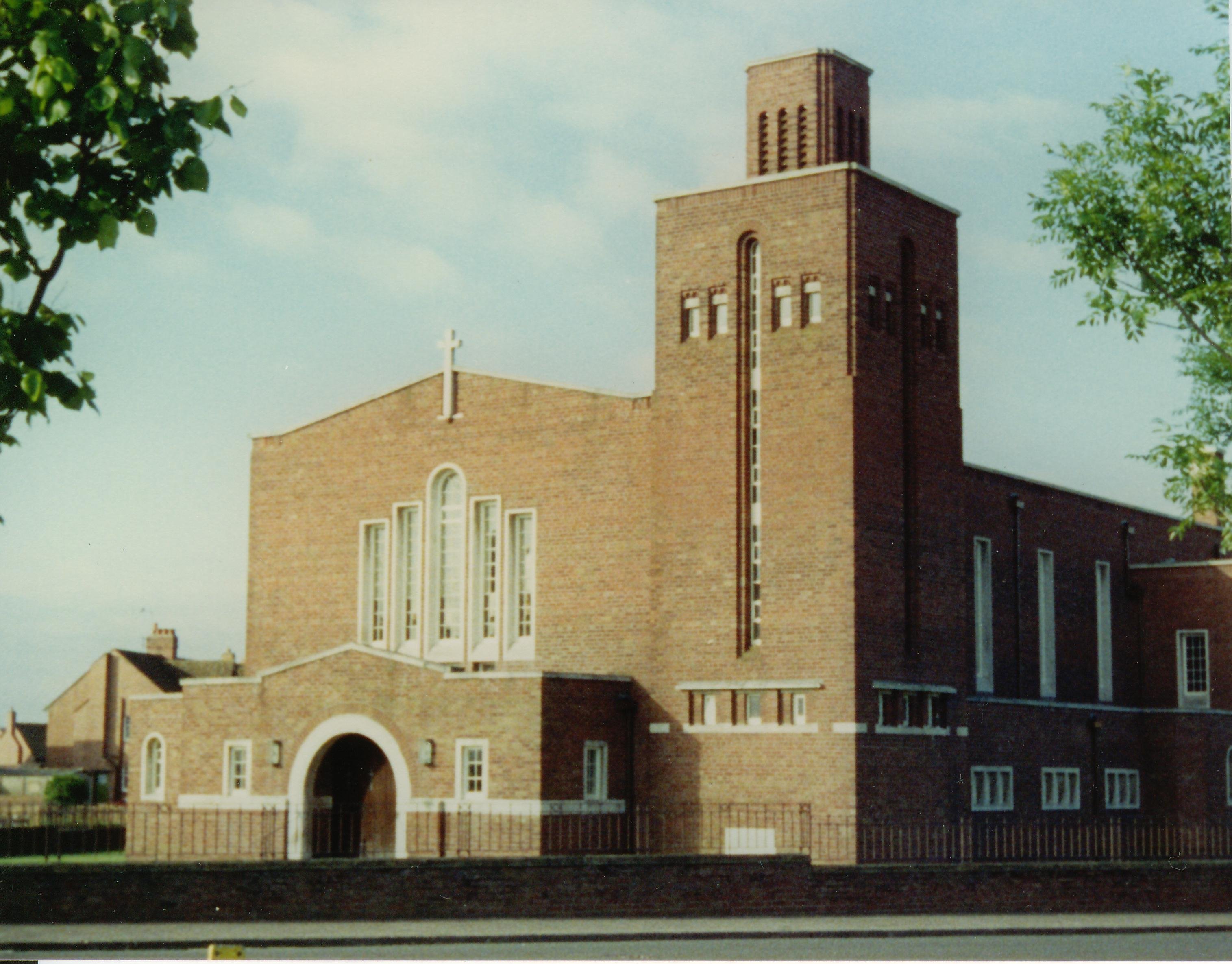
Good Shepherd Cathedral, Ayr

The Good Shepherd Cathedral in Ayr, South Ayrshire, Scotland was the cathedral church of the Roman Catholic Diocese of Galloway. == History == The Church...

Heathfield, South Ayrshire

Heathfield is a major district of Ayr, Scotland. Heathfield is on the borders of Ayr and Prestwick and is located beside the A77 Ayr by-pass. The Whitletts...
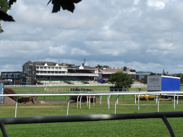
Ayr Racecourse

Ayr Racecourse at Whitletts Road, Ayr, Scotland, was opened in 1907. There are courses for flat and for National Hunt racing. == History == Horse racing...

Nearby Amenities

Located within 500m of 55.47226,-4.607603
Traffic Signals
Lat/Long: 55.4687703/-4.6098374
Traffic Signals
Lat/Long: 55.4688279/-4.6098771
Traffic Signals
Lat/Long: 55.470431/-4.6021256
Traffic Signals
Lat/Long: 55.4703569/-4.6020929
Mini Roundabout
Direction: clockwise
Lat/Long: 55.4683458/-4.6094332
Braehead
Place: suburb
Source: OS7
Lat/Long: 55.4714382/-4.6078706
Barrier: bollard
Lat/Long: 55.4716446/-4.6083899
Atm
Operator: Royal Bank of Scotland
Wheelchair: yes
Lat/Long: 55.4681038/-4.6079441
Post Box
Post Box Type: pillar
Ref: KA8 99
Lat/Long: 55.4691018/-4.610211
Bus Stop
Shelter: yes
Lat/Long: 55.470634/-4.6139076
Bus Stop
Bench: yes
Bus: yes
Naptan AtcoCode: 6190176
Naptan NaptanCode: 29724848
Public Transport: platform
Shelter: yes
Lat/Long: 55.4699723/-4.6119675
Bus Stop
Walker Rd at 29 Walker Rd
Bench: no
Naptan AtcoCode: 6190177
Naptan NaptanCode: 29723729
Ref: 6190177
Shelter: no
Lat/Long: 55.4698439/-4.6120024
Bus Stop
Naptan AtcoCode: 6190146
Naptan NaptanCode: 29723698
Shelter: no
Lat/Long: 55.4686364/-4.610986
Bus Stop
Bus: yes
Naptan AtcoCode: 6190159
Naptan NaptanCode: 29724626
Public Transport: platform
Shelter: yes
Lat/Long: 55.4690312/-4.6084802
Bus Stop
Naptan AtcoCode: 6190147
Naptan NaptanCode: 29723898
Lat/Long: 55.4684239/-4.6112068
Clock
Display: analog
Lat/Long: 55.4681709/-4.6077783
Recycling
Lat/Long: 55.468171/-4.6092683
Bus Stop
Walker Rd near Wilson St
Bench: no
Departures Board: timetable
Naptan AtcoCode: 6190182
Naptan NaptanCode: 29723893
Ref: 6190182
Shelter: no
Lat/Long: 55.470706/-4.6145987
Noexit: yes
Lat/Long: 55.4701777/-4.6067718
Noexit: yes
Lat/Long: 55.4701635/-4.6068285
Post Box
Ref: KA8 169
Lat/Long: 55.4678882/-4.6080529
Styling Room
Addr City: Ayr
Addr Housenumber: 2
Addr Postcode: KA8 0QF
Addr Street: Mainholm Road
Phone: +44 1292 280360
Shop: hairdresser
Lat/Long: 55.4700419/-4.6022237
Mainholm Stores
Addr City: Ayr
Addr Housenumber: 2
Addr Postcode: KA8 0QF
Addr Street: Mainholm Road
Fhrs Id: 1558599
Phone: +44 1292 265286
Shop: convenience
Lat/Long: 55.4699969/-4.602205
Post Box
Ref: KA8 2
Lat/Long: 55.4700888/-4.6020709
Bus Stop
Bench: no
Covered: no
Naptan AtcoCode: 6190145
Naptan NaptanCode: 29724285
Shelter: no
Lat/Long: 55.4696791/-4.6063321
Atm
Lat/Long: 55.468268/-4.6101197
Look Ahead
Addr City: Ayr
Addr Housenumber: 6
Addr Postcode: KA8 9NL
Addr Street: Wills Road
Phone: +44 1292 266030
Shop: hairdresser
Lat/Long: 55.4696377/-4.6079558
Fast Food
Spice Magic
Addr City: Ayr
Addr Housenumber: 2
Addr Postcode: KA8 9NL
Addr Street: Wills Road
Drive Through: no
Phone: +44 1292 288855
Takeaway: only
Lat/Long: 55.4695678/-4.6079034
Ladbrokes
Addr City: Ayr
Addr Housenumber: 157
Addr Postcode: KA8 0JQ
Addr Street: Whitletts Road
Brand: Ladbrokes
Brand Wikidata: Q1799875
Phone: +44 800 0304496
Shop: bookmaker
Lat/Long: 55.4695364/-4.60762
Recycling
We Pay Cash For Clothes
Addr City: Ayr
Addr Street: Whitletts Road
Lat/Long: 55.4695678/-4.6075399
Fast Food
Aldo's
Addr City: Ayr
Addr Housenumber: 157
Addr Postcode: KA8 0JQ
Addr Street: Whitletts Road
Addr Unit: 3
Cuisine: fish_and_chips
Drive Through: no
Fhrs Id: 915234
Phone: +44 1292 611042
Takeaway: only
Lat/Long: 55.4695853/-4.6074536
Tony Currie Solicitors
Addr City: Ayr
Addr Housenumber: 159
Addr Postcode: KA8 0JQ
Addr Street: Whitletts Road
Office: lawyer
Phone: +44 1292 290666
Lat/Long: 55.4696202/-4.6073612
Fast Food
163
Addr City: Ayr
Addr Housenumber: 163
Addr Postcode: KA8 0JQ
Addr Street: Whitletts Road
Cuisine: chinese
Fhrs Id: 1085376
Phone: +44 1292 262166
Lat/Long: 55.4696604/-4.6072318
Gibson And Goold
Addr City: Ayr
Addr Housenumber: 165-167
Addr Postcode: KA8 0JH
Addr Street: Whitletts Road
Phone: +44 1292 268478
Shop: fireplace
Website: http://www.gibsonandgooldayr.co.uk/
Lat/Long: 55.4697006/-4.6070531
Bus Stop
Whitletts Rd opp Galloway Ave
Bench: no
Covered: no
Naptan AtcoCode: 6190144
Naptan NaptanCode: 29723623
Ref: 6190144
Shelter: no
Tactile Paving: yes
Lat/Long: 55.4697774/-4.605133
Fast Food
Relish
Addr City: Ayr
Addr Housenumber: 10
Addr Street: Galloway Avenue
Cuisine: sandwich
Phone: +44 7904 939529
Takeaway: only
Lat/Long: 55.471091/-4.6054576
Galloway Food Store
Addr City: Ayr
Addr Housenumber: 14-18
Addr Postcode: KA8 9NT
Addr Street: Galloway Avenue
Phone: +44 1292 262756
Shop: convenience
Lat/Long: 55.4711928/-4.6055193
Waste Basket
Lat/Long: 55.4712187/-4.6056829
Post Box
Post Box Type: pillar
Ref: KA8 162
Lat/Long: 55.4711069/-4.6123599
Post Box
Post Box Type: pillar
Ref: KA8 149
Lat/Long: 55.4721013/-4.6070784
Entrance: yes
Lat/Long: 55.4757257/-4.6120554
Entrance: yes
Lat/Long: 55.4757812/-4.6120193
Entrance: yes
Lat/Long: 55.4759012/-4.6119472
Entrance: yes
Lat/Long: 55.4759665/-4.6119049
Addr Housenumber: 99
Addr Street: Galloway Avenue
Entrance: yes
Lat/Long: 55.4727711/-4.6092848
Addr Housenumber: 81
Addr Street: Galloway Avenue
Entrance: yes
Lat/Long: 55.4723344/-4.6083439
Addr Housenumber: 83
Addr Street: Galloway Avenue
Entrance: yes
Lat/Long: 55.4723697/-4.6082989
Addr Housenumber: 85
Addr Street: Galloway Avenue
Entrance: yes
Lat/Long: 55.4724227/-4.6085646
Addr Housenumber: 87
Addr Street: Galloway Avenue
Entrance: yes
Lat/Long: 55.47246/-4.608517
Addr Housenumber: 89
Addr Street: Galloway Avenue
Entrance: yes
Lat/Long: 55.4726138/-4.6090306
Addr Housenumber: 91
Addr Street: Galloway Avenue
Entrance: yes
Lat/Long: 55.4726499/-4.6089855
Addr Housenumber: 93
Addr Street: Galloway Avenue
Entrance: yes
Lat/Long: 55.4727048/-4.6092627
Addr Housenumber: 95
Addr Street: Galloway Avenue
Entrance: yes
Lat/Long: 55.4727439/-4.6092139
Addr Housenumber: 97
Addr Street: Galloway Avenue
Entrance: yes
Lat/Long: 55.472728/-4.6093372
Entrance: yes
Lat/Long: 55.4685368/-4.6119809
Entrance: yes
Lat/Long: 55.4685521/-4.6119012
Entrance: yes
Lat/Long: 55.4685997/-4.6116301
Entrance: yes
Lat/Long: 55.4686216/-4.6115122
Entrance: yes
Lat/Long: 55.4686714/-4.6113102
Entrance: yes
Lat/Long: 55.4687006/-4.6111585
Entrance: yes
Lat/Long: 55.4687388/-4.6109758
Entrance: yes
Lat/Long: 55.4687645/-4.6108607
Entrance: yes
Lat/Long: 55.4688159/-4.610645
Entrance: yes
Lat/Long: 55.4688331/-4.6105658
Entrance: yes
Lat/Long: 55.4688818/-4.6103384
Entrance: yes
Lat/Long: 55.4689128/-4.6101887
Entrance: yes
Lat/Long: 55.4691384/-4.6075766
Entrance: yes
Lat/Long: 55.4691652/-4.6074596
Entrance: yes
Lat/Long: 55.4692181/-4.6071926
Entrance: yes
Lat/Long: 55.4692323/-4.6071285
Entrance: yes
Lat/Long: 55.4693008/-4.6068342
Entrance: yes
Lat/Long: 55.4693158/-4.6067693
Entrance: yes
Lat/Long: 55.4693928/-4.6065124
Entrance: yes
Lat/Long: 55.4694397/-4.6062982
Entrance: yes
Lat/Long: 55.4694871/-4.6059996
Entrance: yes
Lat/Long: 55.4695024/-4.6059326
Entrance: yes
Lat/Long: 55.4695866/-4.6056483
Entrance: yes
Lat/Long: 55.4696363/-4.6054343
Entrance: yes
Lat/Long: 55.4696843/-4.6051443
Entrance: yes
Lat/Long: 55.4696999/-4.6050774
Entrance: yes
Lat/Long: 55.4697796/-4.6047943
Entrance: yes
Lat/Long: 55.4698105/-4.6046584
Entrance: yes
Lat/Long: 55.4698562/-4.6044031
Entrance: yes
Lat/Long: 55.4698876/-4.6042638
Entrance: yes
Lat/Long: 55.4699321/-4.6040491
Entrance: yes
Lat/Long: 55.4699662/-4.6038984
Entrance: yes
Lat/Long: 55.470014/-4.6036483
Entrance: yes
Lat/Long: 55.4700566/-4.6034136
Entrance: yes
Lat/Long: 55.4700883/-4.6031679
Entrance: yes
Lat/Long: 55.4701206/-4.6029307
Entrance: yes
Lat/Long: 55.4701389/-4.6027852
Entrance: yes
Lat/Long: 55.4701682/-4.6025452
Entrance: yes
Lat/Long: 55.4702017/-4.6023158
Information & Advice Hub
Information: office
Operator: South Ayrshire Council
Tourism: information
Lat/Long: 55.4701434/-4.6017208
Generator Method: photovoltaic
Generator Output Electricity: yes
Generator Source: solar
Generator Type: solar_photovoltaic_panel
Power: generator
Lat/Long: 55.4764059/-4.6086185
Generator Method: photovoltaic
Generator Output Electricity: yes
Generator Source: solar
Generator Type: solar_photovoltaic_panel
Power: generator
Lat/Long: 55.4760766/-4.6081284
Barrier: bollard
Lat/Long: 55.4716026/-4.6084539
Generator Method: photovoltaic
Generator Output Electricity: yes
Generator Source: solar
Generator Type: solar_photovoltaic_panel
Power: generator
Lat/Long: 55.4737178/-4.6081968
Generator Method: photovoltaic
Generator Output Electricity: yes
Generator Source: solar
Generator Type: solar_photovoltaic_panel
Power: generator
Lat/Long: 55.4728904/-4.607158
Addr Housenumber: 68
Lat/Long: 55.4722893/-4.6025817
Addr Housenumber: 51
Lat/Long: 55.472974/-4.6084059
Addr Housenumber: 82
Lat/Long: 55.4732617/-4.6042096
Addr Housenumber: 72
Lat/Long: 55.4724724/-4.6025747
Addr Housenumber: 66
Lat/Long: 55.4721945/-4.6024792
Addr Housenumber: 124
Lat/Long: 55.4732436/-4.6090358
Bus Stop
Bus: yes
Public Transport: platform
Lat/Long: 55.4735122/-4.6038114
Addr Housenumber: 80
Lat/Long: 55.4732368/-4.604446
Addr Housenumber: 70
Lat/Long: 55.4723659/-4.6026052
Addr Housenumber: 47
Lat/Long: 55.4728608/-4.6085806
Addr Housenumber: 62
Lat/Long: 55.4730119/-4.6066125
Addr Housenumber: 115
Lat/Long: 55.4736584/-4.6033785
Addr Housenumber: 60
Lat/Long: 55.4720092/-4.6024618
Addr Housenumber: 76
Lat/Long: 55.4726015/-4.6026755
Addr Housenumber: 107
Lat/Long: 55.4735692/-4.6038732
Addr Housenumber: 49
Lat/Long: 55.4730112/-4.6084751
Addr Housenumber: 58
Lat/Long: 55.4719498/-4.6024468
Addr Housenumber: 120
Lat/Long: 55.4731304/-4.6092084
Addr Housenumber: 109
Lat/Long: 55.4735822/-4.6037806
Addr Housenumber: 45
Lat/Long: 55.4728988/-4.6086432
Addr Housenumber: 56
Lat/Long: 55.4719053/-4.6023472
Addr Housenumber: 74
Lat/Long: 55.4725354/-4.6025903
Addr Housenumber: 105
Lat/Long: 55.4735687/-4.6040743
Addr Housenumber: 62
Lat/Long: 55.4720853/-4.6024175
Addr Housenumber: 126
Lat/Long: 55.4732014/-4.6089497
Addr Housenumber: 122
Lat/Long: 55.4730849/-4.6091259
Addr Housenumber: 113
Lat/Long: 55.473611/-4.6035448
Addr Housenumber: 66
Lat/Long: 55.4730113/-4.606366
Addr Housenumber: 117
Lat/Long: 55.4736775/-4.6032481
Addr Housenumber: 111
Lat/Long: 55.4736031/-4.6036493
Addr Housenumber: 68
Lat/Long: 55.4730109/-4.6062596
Addr Housenumber: 78
Lat/Long: 55.4726667/-4.6026891
Bus Stop
Ferguson St after Cowan Cr
Bench: yes
Bus: yes
Public Transport: platform
Ref: 6190175
Shelter: yes
Lat/Long: 55.473234/-4.6061604
Addr Housenumber: 64
Lat/Long: 55.472141/-4.6024606
Addr Housenumber: 103
Lat/Long: 55.4735529/-4.6041977
Addr Housenumber: 78
Lat/Long: 55.4732027/-4.604702
Addr Housenumber: 64
Lat/Long: 55.4730076/-4.6064815
Addr City: Ayr
Addr Housenumber: 6
Addr Postcode: KA8 9LB
Addr Street: Walker Road
Lat/Long: 55.4700685/-4.6119404
Addr City: Ayr
Addr Housenumber: 43
Addr Postcode: KA8 9JZ
Addr Street: Walker Road
Lat/Long: 55.4699698/-4.6127568
Addr City: Ayr
Addr Housenumber: 4
Addr Postcode: KA8 9LB
Addr Street: Walker Road
Lat/Long: 55.4700112/-4.6116256
Addr Housenumber: 75
Addr Street: Walker Road
Lat/Long: 55.4706059/-4.6147226
Addr Housenumber: 81
Addr Street: Walker Road
Lat/Long: 55.4707087/-4.6148407
Addr City: Ayr
Addr Housenumber: 44
Addr Postcode: KA8 9LD
Addr Street: Walker Road
Lat/Long: 55.4707737/-4.6140322
Addr City: Ayr
Addr Housenumber: 28
Addr Postcode: KA8 9LB
Addr Street: Walker Road
Lat/Long: 55.4703406/-4.6125815
Addr City: Ayr
Addr Housenumber: 41
Addr Postcode: KA8 9JZ
Addr Street: Walker Road
Lat/Long: 55.4699785/-4.6126523
Addr City: Ayr
Addr Housenumber: 10
Addr Postcode: KA8 9LB
Addr Street: Walker Road
Lat/Long: 55.4700974/-4.6120161
Addr Housenumber: 56
Addr Street: Walker Road
Lat/Long: 55.4709252/-4.6144164
Addr City: Ayr
Addr Housenumber: 48
Addr Postcode: KA8 9LD
Addr Street: Walker Road
Lat/Long: 55.4707977/-4.6141079
Addr City: Ayr
Addr Housenumber: 47
Addr Postcode: KA8 9JZ
Addr Street: Walker Road
Lat/Long: 55.4700524/-4.6129853
Addr City: Ayr
Addr Housenumber: 30
Addr Postcode: KA8 9LB
Addr Street: Walker Road
Lat/Long: 55.4704022/-4.6129015
Addr City: Ayr
Addr Housenumber: 38
Addr Postcode: KA8 9LD
Addr Street: Walker Road
Lat/Long: 55.4706991/-4.613796
Addr City: Ayr
Addr Housenumber: 18
Addr Postcode: KA8 9LB
Addr Street: Walker Road
Lat/Long: 55.4702404/-4.6122719
Addr City: Ayr
Addr Housenumber: 24
Addr Postcode: KA8 9LB
Addr Street: Walker Road
Lat/Long: 55.4702779/-4.612549
Addr City: Ayr
Addr Housenumber: 35
Addr Postcode: KA8 9JZ
Addr Street: Walker Road
Lat/Long: 55.469866/-4.6124557
Addr City: Ayr
Addr Housenumber: 50
Addr Postcode: KA8 9LD
Addr Street: Walker Road
Lat/Long: 55.4709083/-4.6143033
Addr City: Ayr
Addr Housenumber: 2
Addr Postcode: KA8 9LB
Addr Street: Walker Road
Lat/Long: 55.4699737/-4.6116671
Addr City: Ayr
Addr Housenumber: 45
Addr Postcode: KA8 9JZ
Addr Street: Walker Road
Lat/Long: 55.4700028/-4.6127203
Addr Housenumber: 69
Addr Street: Walker Road
Lat/Long: 55.4705498/-4.614353
Addr City: Ayr
Addr Housenumber: 26
Addr Postcode: KA8 9LB
Addr Street: Walker Road
Lat/Long: 55.4703073/-4.612617
Addr City: Ayr
Addr Housenumber: 55
Addr Postcode: KA8 9JZ
Addr Street: Walker Road
Lat/Long: 55.4701537/-4.6132835
Addr City: Ayr
Addr Housenumber: 57
Addr Postcode: KA8 9JZ
Addr Street: Walker Road
Lat/Long: 55.4701853/-4.6132494
Addr City: Ayr
Addr Housenumber: 12
Addr Postcode: KA8 9LB
Addr Street: Walker Road
Lat/Long: 55.4701352/-4.6119749
Addr City: Ayr
Addr Housenumber: 46
Addr Postcode: KA8 9LD
Addr Street: Walker Road
Lat/Long: 55.4708371/-4.614071
Addr City: Ayr
Addr Housenumber: 29
Addr Postcode: KA8 9JZ
Addr Street: Walker Road
Lat/Long: 55.4697935/-4.6121183
Addr Housenumber: 71
Addr Street: Walker Road
Lat/Long: 55.4705776/-4.6144367
Addr City: Ayr
Addr Housenumber: 52
Addr Postcode: KA8 9LD
Addr Street: Walker Road
Lat/Long: 55.4708682/-4.6143407
Addr City: Ayr
Addr Housenumber: 40
Addr Postcode: KA8 9LD
Addr Street: Walker Road
Lat/Long: 55.470741/-4.6137547
Addr City: Ayr
Addr Housenumber: 20
Addr Postcode: KA8 9LB
Addr Street: Walker Road
Lat/Long: 55.4701995/-4.6123162
Addr City: Ayr
Addr Housenumber: 27
Addr Postcode: KA8 9JZ
Addr Street: Walker Road
Lat/Long: 55.4697601/-4.6121552
Addr City: Ayr
Addr Housenumber: 14
Addr Postcode: KA8 9LB
Addr Street: Walker Road
Lat/Long: 55.4701727/-4.6122451
Addr City: Ayr
Addr Housenumber: 22
Addr Postcode: KA8 9LB
Addr Street: Walker Road
Lat/Long: 55.4703201/-4.6125035
Addr Housenumber: 54
Addr Street: Walker Road
Lat/Long: 55.4709202/-4.6144979
Addr City: Ayr
Addr Housenumber: 39
Addr Postcode: KA8 9JZ
Addr Street: Walker Road
Lat/Long: 55.4699431/-4.6126902
Addr City: Ayr
Addr Housenumber: 32
Addr Postcode: KA8 9LB
Addr Street: Walker Road
Lat/Long: 55.4704369/-4.6128645
Addr Housenumber: 63
Addr Street: Walker Road
Lat/Long: 55.4704371/-4.6141597
Addr City: Ayr
Addr Housenumber: 53
Addr Postcode: KA8 9JZ
Addr Street: Walker Road
Lat/Long: 55.4701078/-4.6130153
Addr City: Ayr
Addr Housenumber: 31
Addr Postcode: KA8 9JZ
Addr Street: Walker Road
Lat/Long: 55.4698379/-4.6123891
Addr City: Ayr
Addr Housenumber: 51
Addr Postcode: KA8 9JZ
Addr Street: Walker Road
Lat/Long: 55.4700745/-4.6130513
Addr City: Ayr
Addr Housenumber: 33
Addr Postcode: KA8 9JZ
Addr Street: Walker Road
Lat/Long: 55.4698753/-4.6123478
Addr Housenumber: 73
Addr Street: Walker Road
Lat/Long: 55.4705343/-4.6144783
Addr City: Ayr
Addr Housenumber: 49
Addr Postcode: KA8 9JZ
Addr Street: Walker Road
Lat/Long: 55.4700846/-4.6129497
Addr City: Ayr
Addr Housenumber: 8
Addr Postcode: KA8 9LB
Addr Street: Walker Road
Lat/Long: 55.4701045/-4.6119006
Addr Housenumber: 65
Addr Street: Walker Road
Lat/Long: 55.4704791/-4.6141194
Addr City: Ayr
Addr Housenumber: 37
Addr Postcode: KA8 9JZ
Addr Street: Walker Road
Lat/Long: 55.4698983/-4.6124212
Addr City: Ayr
Addr Housenumber: 16
Addr Postcode: KA8 9LB
Addr Street: Walker Road
Lat/Long: 55.4702127/-4.6122015
Addr Housenumber: 67
Addr Street: Walker Road
Lat/Long: 55.4705073/-4.6143937
Addr Housenumber: 77
Addr Street: Walker Road
Lat/Long: 55.470651/-4.6146792
Addr Housenumber: 79
Addr Street: Walker Road
Lat/Long: 55.4706689/-4.6148282
Addr City: Ayr
Addr Housenumber: 42
Addr Postcode: KA8 9LD
Addr Street: Walker Road
Lat/Long: 55.470815/-4.6139915
Entrance: yes
Lat/Long: 55.4735453/-4.6051261
Entrance: yes
Lat/Long: 55.4734568/-4.6050957
Entrance: yes
Lat/Long: 55.4735773/-4.6048647
Entrance: yes
Lat/Long: 55.4734899/-4.6048335
Entrance: yes
Lat/Long: 55.4738231/-4.6053808
Entrance: yes
Lat/Long: 55.4738789/-4.6054243
Entrance: yes
Lat/Long: 55.4739414/-4.605473
Entrance: yes
Lat/Long: 55.4740025/-4.6055209
Entrance: yes
Lat/Long: 55.4740667/-4.6055697
Entrance: yes
Lat/Long: 55.4741315/-4.6056197
Entrance: yes
Lat/Long: 55.4741921/-4.6056667
Entrance: yes
Lat/Long: 55.4742524/-4.6057141
Entrance: yes
Lat/Long: 55.4743126/-4.6058215
Entrance: yes
Lat/Long: 55.4742872/-4.6059256
Entrance: yes
Lat/Long: 55.47426/-4.6060375
Entrance: yes
Lat/Long: 55.4742359/-4.606137
Entrance: yes
Lat/Long: 55.4740804/-4.6066334
Entrance: yes
Lat/Long: 55.4741076/-4.6065237
Entrance: yes
Lat/Long: 55.4741347/-4.606414
Entrance: yes
Lat/Long: 55.4741629/-4.6063
Entrance: yes
Lat/Long: 55.4740078/-4.6060044
Entrance: yes
Lat/Long: 55.4739879/-4.6059111
Entrance: yes
Lat/Long: 55.4738408/-4.6057558
Entrance: yes
Lat/Long: 55.4737767/-4.6057061
Entrance: yes
Lat/Long: 55.4737135/-4.6056572
Entrance: yes
Lat/Long: 55.4736506/-4.6056085
Entrance: yes
Lat/Long: 55.4738569/-4.6067031
Entrance: yes
Lat/Long: 55.473881/-4.6066049
Entrance: yes
Lat/Long: 55.4739084/-4.6064935
Entrance: yes
Lat/Long: 55.4739345/-4.6063873
Entrance: yes
Lat/Long: 55.4739599/-4.606284
Entrance: yes
Lat/Long: 55.4732051/-4.6081279
Entrance: yes
Lat/Long: 55.4732407/-4.6082356
Entrance: yes
Lat/Long: 55.4732756/-4.608341
Entrance: yes
Lat/Long: 55.473372/-4.6079599
Entrance: yes
Lat/Long: 55.4733048/-4.6079316
Entrance: yes
Lat/Long: 55.4737078/-4.6070206
Entrance: yes
Lat/Long: 55.4737751/-4.6069603
Entrance: yes
Lat/Long: 55.4738208/-4.6076898
Entrance: yes
Lat/Long: 55.473849/-4.6075786
Entrance: yes
Lat/Long: 55.4738761/-4.6074721
Entrance: yes
Lat/Long: 55.4739045/-4.6073603
Entrance: yes
Lat/Long: 55.4734934/-4.606522
Entrance: yes
Lat/Long: 55.4735092/-4.6063809
Entrance: yes
Lat/Long: 55.4735284/-4.6061948
Entrance: yes
Lat/Long: 55.4735432/-4.6060546
Entrance: yes
Lat/Long: 55.4733636/-4.6068723
Entrance: yes
Lat/Long: 55.4734435/-4.6069583
Entrance: yes
Lat/Long: 55.4735124/-4.6069812
Entrance: yes
Lat/Long: 55.4735751/-4.607002
Entrance: yes
Lat/Long: 55.4732316/-4.6068616
Entrance: yes
Lat/Long: 55.4732004/-4.6067804
Entrance: yes
Lat/Long: 55.4731543/-4.6073518
Entrance: yes
Lat/Long: 55.4732143/-4.6072748
Entrance: yes
Lat/Long: 55.4735077/-4.6073212
Entrance: yes
Lat/Long: 55.4734382/-4.6072989
Entrance: yes
Lat/Long: 55.4733697/-4.6072769
Entrance: yes
Lat/Long: 55.4736506/-4.6075483
Entrance: yes
Lat/Long: 55.4736226/-4.607661
Entrance: yes
Lat/Long: 55.4735961/-4.6077678
Entrance: yes
Lat/Long: 55.4735685/-4.607879
Entrance: yes
Lat/Long: 55.4735704/-4.6083689
Entrance: yes
Lat/Long: 55.4736366/-4.6083195
Entrance: yes
Lat/Long: 55.4737/-4.6081901
Entrance: yes
Lat/Long: 55.4737255/-4.6080896
Entrance: yes
Lat/Long: 55.4737522/-4.6079841
Entrance: yes
Lat/Long: 55.4737783/-4.6078808
Entrance: yes
Lat/Long: 55.4739522/-4.6071613
Entrance: yes
Lat/Long: 55.4739799/-4.6070498
Entrance: yes
Lat/Long: 55.4740068/-4.6069411
Entrance: yes
Lat/Long: 55.4740348/-4.6068282
Entrance: yes
Lat/Long: 55.4735286/-4.6044781
Entrance: yes
Lat/Long: 55.4735406/-4.6043782
Entrance: yes
Lat/Long: 55.4732959/-4.6039045
Entrance: yes
Lat/Long: 55.4733153/-4.6037838
Entrance: yes
Lat/Long: 55.4733653/-4.6058669
Entrance: yes
Lat/Long: 55.4733813/-4.6057281
Entrance: yes
Lat/Long: 55.4734024/-4.6055547
Entrance: yes
Lat/Long: 55.4734141/-4.605456
Generator Method: photovoltaic
Generator Output Electricity: yes
Generator Source: solar
Generator Type: solar_photovoltaic_panel
Power: generator
Lat/Long: 55.4713934/-4.6011493
Generator Method: photovoltaic
Generator Output Electricity: yes
Generator Source: solar
Generator Type: solar_photovoltaic_panel
Power: generator
Lat/Long: 55.4713568/-4.6011691
Generator Method: photovoltaic
Generator Output Electricity: yes
Generator Source: solar
Generator Type: solar_photovoltaic_panel
Power: generator
Lat/Long: 55.4724678/-4.6016173
Generator Method: photovoltaic
Generator Output Electricity: yes
Generator Source: solar
Generator Type: solar_photovoltaic_panel
Power: generator
Lat/Long: 55.4726324/-4.5998282
Entrance: yes
Lat/Long: 55.4693754/-4.6108138
Entrance: yes
Lat/Long: 55.4693389/-4.6107143
Entrance: yes
Lat/Long: 55.4692561/-4.6105499
Entrance: yes
Lat/Long: 55.4692119/-4.6104629
Entrance: yes
Lat/Long: 55.4691565/-4.6110952
Entrance: yes
Lat/Long: 55.4690939/-4.6111637
Entrance: yes
Lat/Long: 55.4690658/-4.6114207
Entrance: yes
Lat/Long: 55.4690313/-4.6113235
Entrance: yes
Lat/Long: 55.4692371/-4.6113296
Entrance: yes
Lat/Long: 55.4691796/-4.6113925
Entrance: yes
Lat/Long: 55.4694764/-4.6111072
Entrance: yes
Lat/Long: 55.4695115/-4.611208
Entrance: yes
Lat/Long: 55.4718289/-4.6030505
Entrance: yes
Lat/Long: 55.4717747/-4.6029758
Entrance: yes
Lat/Long: 55.4717219/-4.6029028
Entrance: yes
Lat/Long: 55.471666/-4.6028257
Entrance: yes
Lat/Long: 55.4728512/-4.6031906
Entrance: yes
Lat/Long: 55.4727839/-4.6031682
Entrance: yes
Lat/Long: 55.4727162/-4.6031456
Entrance: yes
Lat/Long: 55.4726465/-4.6031223
Entrance: yes
Lat/Long: 55.4725224/-4.6031102
Entrance: yes
Lat/Long: 55.4724553/-4.6030859
Entrance: yes
Lat/Long: 55.4723865/-4.6030611
Entrance: yes
Lat/Long: 55.4723185/-4.6030365
Entrance: yes
Lat/Long: 55.4733249/-4.6033982
Entrance: yes
Lat/Long: 55.4733537/-4.6034866
Entrance: yes
Lat/Long: 55.4733911/-4.602977
Entrance: yes
Lat/Long: 55.4734398/-4.6029242
Entrance: yes
Lat/Long: 55.4731571/-4.6051396
Entrance: yes
Lat/Long: 55.4731656/-4.6050175
Entrance: yes
Lat/Long: 55.4729331/-4.6071638
Entrance: yes
Lat/Long: 55.4729373/-4.60704
Entrance: yes
Lat/Long: 55.4729415/-4.6069181
Entrance: yes
Lat/Long: 55.4729457/-4.6067957
Entrance: yes
Lat/Long: 55.4728948/-4.6074886
Entrance: yes
Lat/Long: 55.4728975/-4.6073646
Entrance: yes
Lat/Long: 55.4732238/-4.6029426
Entrance: yes
Lat/Long: 55.4731566/-4.6029174
Entrance: yes
Lat/Long: 55.473167/-4.6033516
Entrance: yes
Lat/Long: 55.4730993/-4.6033266
Entrance: yes
Lat/Long: 55.4730309/-4.6033013
Entrance: yes
Lat/Long: 55.4729626/-4.603276
Entrance: yes
Lat/Long: 55.4728056/-4.6026719
Entrance: yes
Lat/Long: 55.4728592/-4.6026914
Entrance: yes
Lat/Long: 55.4730369/-4.6028206
Entrance: yes
Lat/Long: 55.4729535/-4.6027894
Entrance: yes
Lat/Long: 55.4704242/-4.6139169
Entrance: yes
Lat/Long: 55.4703784/-4.613902
Entrance: yes
Lat/Long: 55.4704728/-4.6131192
Entrance: yes
Lat/Long: 55.4706261/-4.6135894
Entrance: yes
Lat/Long: 55.4706347/-4.6135089
The data included in this document is from www.openstreetmap.org. The data is made available under ODbL.

Have you been to Braehead?

Leave your review of Braehead below (or comments, questions and feedback).