Hagbourne, West

Settlement in Berkshire South Oxfordshire

England

Hagbourne, West

Byway to West Hagbourne Byway to West Hagbourne passing right turn up to East Hagbourne
Byway to West Hagbourne Credit: Shaun Ferguson

Hagbourne, West is a charming village located in the county of Berkshire, England. Situated approximately 3 miles southeast of Didcot, it is nestled in the picturesque countryside, offering residents and visitors a peaceful and idyllic setting. The village is part of the civil parish of East Hagbourne and West Hagbourne, collectively known as Hagbourne.

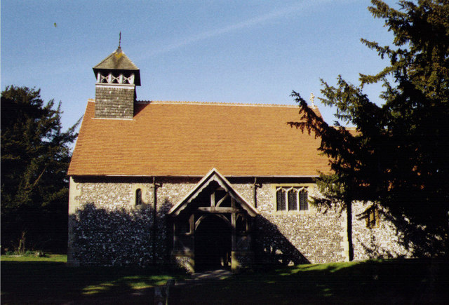
Hagbourne, West boasts a rich history dating back centuries. It is believed that the village was originally settled in the Saxon period, and evidence of this can still be seen today in the form of the beautiful St. Andrew's Church, which dates back to the 12th century. The church is an architectural gem and a prominent landmark in the village.

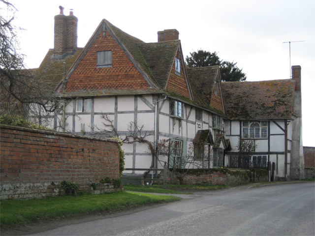
The village is known for its close-knit community and traditional English charm. It features a range of period cottages and houses, many of which are constructed from the local and distinctive Hagbourne brick. The village is also home to a village hall, a primary school, and a thriving local pub, providing essential amenities for its residents.

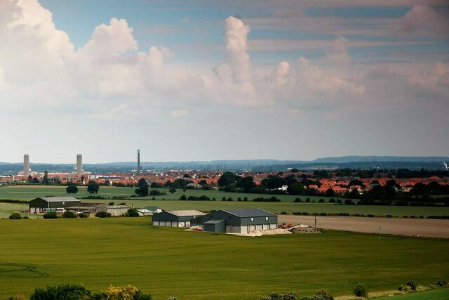
Surrounded by stunning countryside, Hagbourne, West offers plenty of opportunities for outdoor activities and exploration. The nearby Hagbourne Hill and the surrounding downs provide breathtaking views of the surrounding landscape and are popular spots for walking and hiking enthusiasts.

Overall, Hagbourne, West, Berkshire is a delightful village that combines history, natural beauty, and a strong sense of community, making it an attractive place to live or visit for those seeking a tranquil and picturesque slice of English countryside.

If you have any feedback on the listing, please let us know in the comments section below.

Hagbourne, West Images

Images are sourced within 2km of 51.586716/-1.2604581 or Grid Reference SU5187. Thanks to Geograph Open Source API. All images are credited.

Byway to West Hagbourne Byway to West Hagbourne passing right turn up to East Hagbourne
Byway to West Hagbourne
Byway to West Hagbourne passing right turn up to East Hagbourne
Byway heads under the old railway bridge From West Hagbourne the byway heads under the old railway bridge part of former Didcot to Newbury line
Byway heads under the old railway bridge
From West Hagbourne the byway heads under the old railway bridge part of former Didcot to Newbury line
Byway to The Driftway Byway to The Driftway cuts across the byway to West Hagbourne to the left
Byway to The Driftway
Byway to The Driftway cuts across the byway to West Hagbourne to the left
The Driftway Byway From Main Street, The Driftway byway heads to Didcot Road.
The Driftway Byway
From Main Street, The Driftway byway heads to Didcot Road.
Driftway Byway The Driftway Byway heading to Main Street
Driftway Byway
The Driftway Byway heading to Main Street
Lynch Way Track Off London Road the Lynch Way track byway heads towards Prospect Farm
Lynch Way Track
Off London Road the Lynch Way track byway heads towards Prospect Farm
Lynch Way Track Lynch Way track byway heads towards Prospect Farm
Lynch Way Track
Lynch Way track byway heads towards Prospect Farm
No towers Changed a bit since I first looked at this view back in 2012 <a href="https://www.geograph.org.uk/photo/2822481">SU5087 : Power station in the distance</a>
No towers
Changed a bit since I first looked at this view back in 2012 SU5087 : Power station in the distance
A change of view Back in 2008 I took this photo of the corn store and Didcot power station <a href="https://www.geograph.org.uk/photo/1041761">SU5087 : Didcot Power station</a>. Since then a housing estate has been built, the power station demolished and the corn store enlarged.
A change of view
Back in 2008 I took this photo of the corn store and Didcot power station SU5087 : Didcot Power station. Since then a housing estate has been built, the power station demolished and the corn store enlarged.
Rush hour in East Hagbourne
East Hagbourne War Memorial: late March 2022
Traffic jam in East Hagbourne
St Andrew, East Hagbourne: churchyard (1)
St Andrew, East Hagbourne: churchyard (2)
St Andrew, East Hagbourne: churchyard (3)
St Andrew, East Hagbourne: churchyard (4)
Inside St Andrew, East Hagbourne (a)
Inside St Andrew, East Hagbourne (b)
Show me another place!

Hagbourne, West is located at Grid Ref: SU5187 (Lat: 51.586716, Lng: -1.2604581)

Administrative County: Oxfordshire

District: South Oxfordshire

Police Authority: Thames Valley

What 3 Words

///submerged.riverbed.hounded. Near Harwell, Oxfordshire

Related Wikis

West Hagbourne

West Hagbourne is a village and civil parish in the Berkshire Downs about 2 miles (3 km) south of Didcot. The 2011 Census recorded a parish population...

Coscote

Coscote is a hamlet in the civil parish of East Hagbourne, in the Berkshire Downs 1 mile (1.6 km) south of Didcot. The hamlet was also previously referred...

Upton and Blewbury railway station

Upton and Blewbury railway station was a station on the Didcot, Newbury and Southampton Railway in England. It served Upton, with Blewbury and West Hagbourne...

Upton, Vale of White Horse

Upton is a spring line village and civil parish at the foot of the Berkshire Downs, about 2 miles (3 km) south of Didcot in the Vale of the White Horse...

Nearby Amenities

Located within 500m of 51.586716,-1.2604581
West Hagbourne
Place: village
Population: 265
Source: NPE
Lat/Long: 51.5875468/-1.2617513
Main Street
Naptan AtcoCode: 340000803OPP
Naptan Bearing: S
Naptan BusStopType: CUS
Naptan CommonName: Main Street
Naptan Indicator: Opposite York Road
Naptan Landmark: Opp Bus Shelter
Naptan NaptanCode: oxfgjwmg
Naptan Street: Main Street
Naptan Verified: no
Source: naptan_import
Lat/Long: 51.5864567/-1.2604752
Bus Stop
Main Street
Naptan AtcoCode: 340000803STO
Naptan Bearing: N
Naptan CommonName: Main Street
Naptan Indicator: York Road Corner
Naptan Landmark: Bus Shelter
Naptan NaptanCode: oxfamwmw
Naptan Street: Main Street
Naptan Verified: no
Shelter: yes
Source: naptan_import
Lat/Long: 51.5866349/-1.2605557
Post Box
Operator: Royal Mail
Post Box Design: type_n
Post Box Type: lamp
Ref: OX11 1075
Lat/Long: 51.5866666/-1.2605611
Bench
Lat/Long: 51.5830209/-1.2575448
Bench
Lat/Long: 51.5843052/-1.2552943
Ash Farm
Place: farm
Source: OS OpenData StreetView
Lat/Long: 51.5864117/-1.2616311
Power: pole
Source: Bing
Lat/Long: 51.5826558/-1.2597894
Power: pole
Source: Bing
Lat/Long: 51.5827699/-1.2624836
Power: pole
Source: Bing
Lat/Long: 51.5824949/-1.2616172
Power: pole
Source: Bing
Lat/Long: 51.5833075/-1.2597787
Power: pole
Source: Bing
Lat/Long: 51.5831595/-1.2636832
Defibrillator
Booth: K6
Covered: booth
Defibrillator Location: inside old red phone box at junction of Main Street and York Road in West Hagbourne
Disused Amenity: telephone
Emergency: defibrillator
Man Made: telephone_box
Lat/Long: 51.5867034/-1.2605666
Give Way
Lat/Long: 51.5868274/-1.260358
Give Way
Lat/Long: 51.5867394/-1.2604876
Give Way
Lat/Long: 51.5868526/-1.260585
Crossing
Crossing: unmarked
Kerb: lowered
Tactile Paving: no
Lat/Long: 51.5868418/-1.2601805
Give Way
Lat/Long: 51.587051/-1.2628712
Barrier: stile
Lat/Long: 51.5873911/-1.2605407
Power: pole
Lat/Long: 51.5836574/-1.2649445
Direction: 170
Generator Method: photovoltaic
Generator Output Electricity: yes
Generator Solar Modules: 10
Generator Source: solar
Generator Type: solar_photovoltaic_panel
Location: roof
Power: generator
Lat/Long: 51.5869936/-1.2566103
Direction: 175
Fixme: survey for panel count
Generator Method: photovoltaic
Generator Output Electricity: yes
Generator Solar Modules: 22
Generator Source: solar
Generator Type: solar_photovoltaic_panel
Location: roof
Power: generator
Lat/Long: 51.5866744/-1.2594527
Direction: 85
Fixme: survey for panel count
Generator Method: photovoltaic
Generator Output Electricity: yes
Generator Solar Modules: 22
Generator Source: solar
Generator Type: solar_photovoltaic_panel
Location: roof
Power: generator
Lat/Long: 51.5866441/-1.2595133
Direction: 265
Fixme: survey for panel count
Generator Method: photovoltaic
Generator Output Electricity: yes
Generator Solar Modules: 16
Generator Source: solar
Generator Type: solar_photovoltaic_panel
Location: roof
Power: generator
Lat/Long: 51.5866505/-1.2595566
Direction: 185
Fixme: survey for panel count
Generator Method: photovoltaic
Generator Output Electricity: yes
Generator Solar Modules: 10
Generator Source: solar
Generator Type: solar_photovoltaic_panel
Location: roof
Power: generator
Lat/Long: 51.5860244/-1.2623962
Direction: 275
Generator Method: photovoltaic
Generator Output Electricity: yes
Generator Solar Modules: 15
Generator Source: solar
Generator Type: solar_photovoltaic_panel
Location: roof
Power: generator
Lat/Long: 51.5861438/-1.262421
Direction: 185
Generator Method: photovoltaic
Generator Output Electricity: yes
Generator Solar Modules: 15
Generator Source: solar
Generator Type: solar_photovoltaic_panel
Location: roof
Power: generator
Lat/Long: 51.5862178/-1.2623948
Direction: 185
Generator Method: photovoltaic
Generator Output Electricity: yes
Generator Solar Modules: 16
Generator Source: solar
Generator Type: solar_photovoltaic_panel
Location: roof
Power: generator
Lat/Long: 51.5863417/-1.2623724
Direction: 130
Generator Method: photovoltaic
Generator Output Electricity: yes
Generator Solar Modules: 11
Generator Source: solar
Generator Type: solar_photovoltaic_panel
Location: roof
Power: generator
Lat/Long: 51.5878866/-1.2649109
The data included in this document is from www.openstreetmap.org. The data is made available under ODbL.

Have you been to Hagbourne, West?

Leave your review of Hagbourne, West below (or comments, questions and feedback).