Bradmore

Settlement in Nottinghamshire Rushcliffe

England

Bradmore

Cottage on Moor Lane, Bunny
Cottage on Moor Lane, Bunny Credit: Neil Theasby

Bradmore is a small village located in the county of Nottinghamshire, England. Situated approximately 5 miles south of Nottingham city center, it falls within the Rushcliffe borough. With a population of around 600 residents, it presents a close-knit and friendly community.

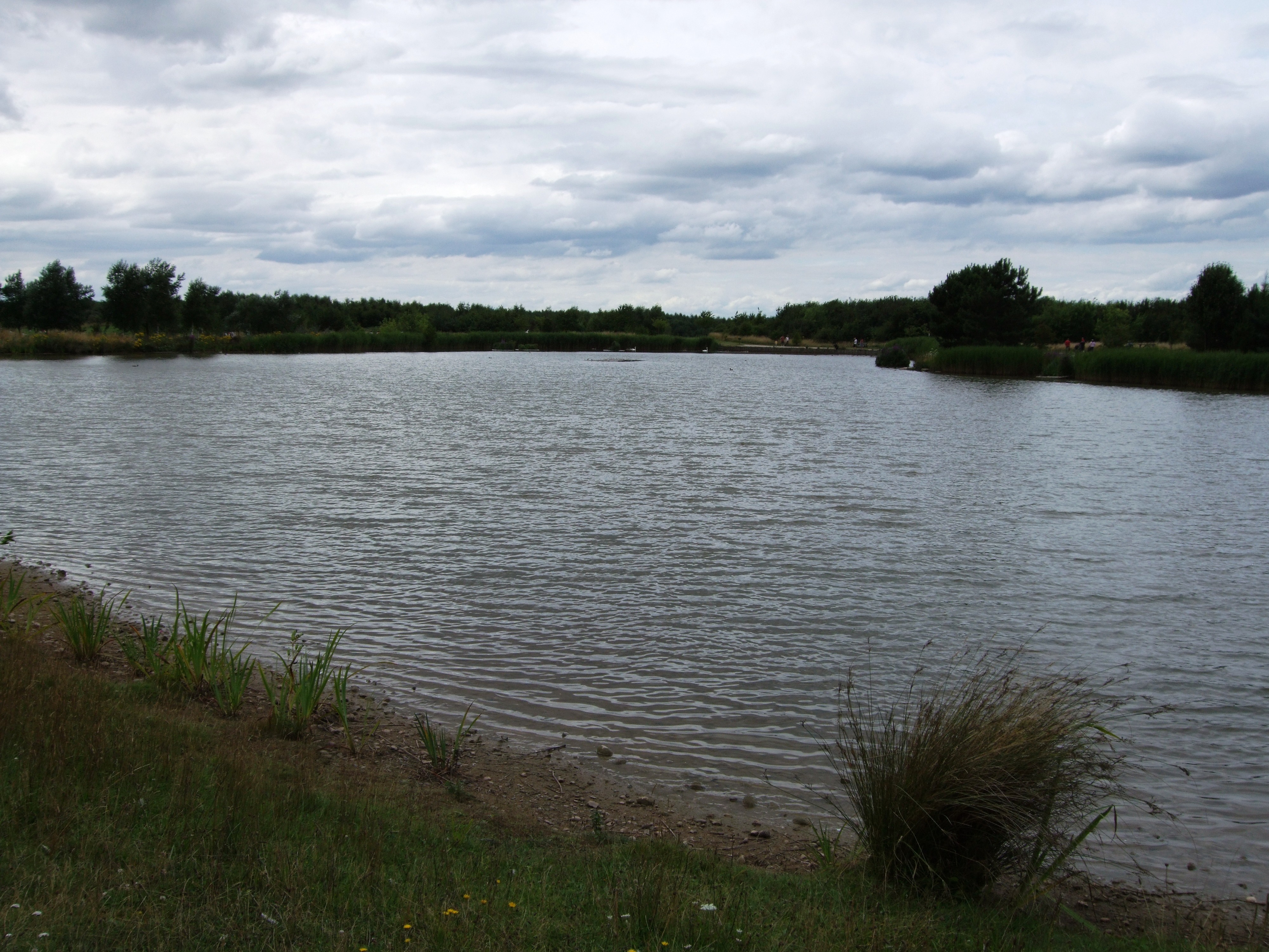
The village is known for its picturesque surroundings, nestled amidst the rolling countryside of the East Midlands. It offers a peaceful and tranquil atmosphere, making it an ideal place for those seeking a rural retreat while still having easy access to urban amenities.

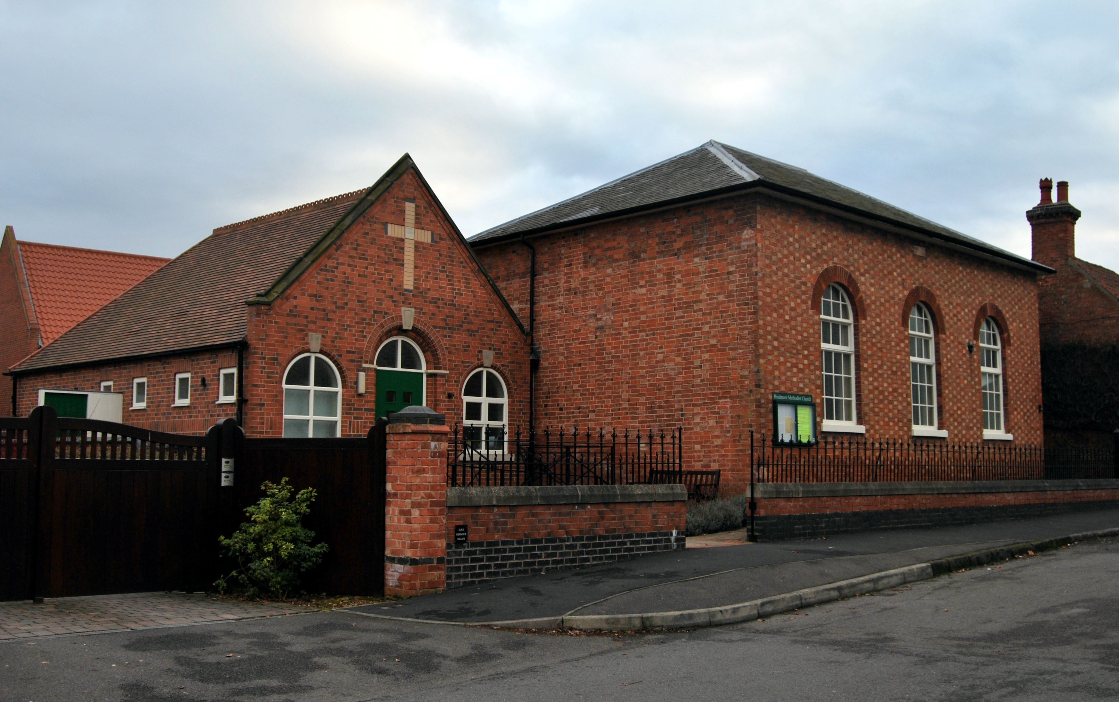
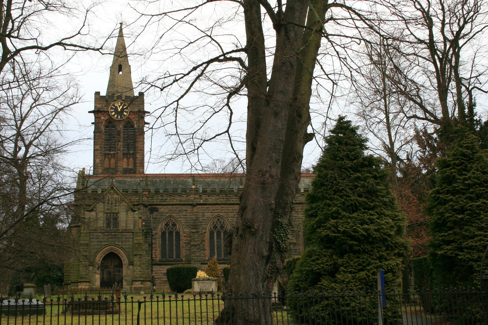
Bradmore boasts a rich history, dating back to the medieval era. The village is home to St. Mary's Church, a charming place of worship with origins dating back to the 12th century. The church is a notable landmark and adds to the village's historic charm.

Despite its small size, Bradmore is well-served by local amenities. The village has a primary school, providing education for children in the area. Additionally, there is a village hall that serves as a hub for community activities and events.

For those seeking recreational activities, Bradmore offers beautiful surrounding countryside, perfect for outdoor pursuits such as walking, cycling, and horse riding. The village is also situated close to the renowned Wollaton Park, a vast green space that provides opportunities for leisure and wildlife observation.

Overall, Bradmore is a tranquil village with a rich history and a strong sense of community. Its idyllic location and access to amenities make it an attractive place to live or visit for those seeking a peaceful and rural lifestyle.

If you have any feedback on the listing, please let us know in the comments section below.

Bradmore Images

Images are sourced within 2km of 52.874919/-1.1322276 or Grid Reference SK5831. Thanks to Geograph Open Source API. All images are credited.

Cottage on Moor Lane, Bunny
St Mary's Church, Bunny The present church dates from the 14th century. It was restored in 1718 for Sir Thomas Parkyns of Bunny Hall. There were also later restorations in 1890–1891 and 1911. The initial 14th-century build was temporarily halted by the spread of the plague into the village in 1350. The present building has developed over several centuries and is now Grade I listed. (from Wikipedia)
St Mary's Church, Bunny
The present church dates from the 14th century. It was restored in 1718 for Sir Thomas Parkyns of Bunny Hall. There were also later restorations in 1890–1891 and 1911. The initial 14th-century build was temporarily halted by the spread of the plague into the village in 1350. The present building has developed over several centuries and is now Grade I listed. (from Wikipedia)
View to Moor End Farm near Bunny
Church Street, Bunny Recreating this 'First' for the square <a title="https://www.geograph.org.uk/photo/4252" href="https://www.geograph.org.uk/photo/4252">Link</a> . It turns out to be like one of the 'spot the changes' puzzles. I've spotted 5, none of which are very obvious, apart from the boarded up window on the Old School.
Church Street, Bunny
Recreating this 'First' for the square Link . It turns out to be like one of the 'spot the changes' puzzles. I've spotted 5, none of which are very obvious, apart from the boarded up window on the Old School.
Gateway to the Silver Seal Mine The public footpath diverts off the mine track through a kissing gate onto Wysall Lane.
Gateway to the Silver Seal Mine
The public footpath diverts off the mine track through a kissing gate onto Wysall Lane.
Farm land near Bunny Hall The Hall is just visible near the left of the picture.
Farm land near Bunny Hall
The Hall is just visible near the left of the picture.
Bunny Hall and Church Viewed from Wysall Road on Windmill Hill.

Taken from almost exactly the same viewpoint as <a title="https://www.geograph.org.uk/photo/3340502" href="https://www.geograph.org.uk/photo/3340502">Link</a> but on a much clearer day. I was surprised just how far away some of the visible features are. The large house on the skyline 'attached' to the tower of the hall is Hopwell Hall <a title="https://www.geograph.org.uk/photo/855336" href="https://www.geograph.org.uk/photo/855336">Link</a> some 10 miles distant.
Bunny Hall and Church
Viewed from Wysall Road on Windmill Hill. Taken from almost exactly the same viewpoint as Link but on a much clearer day. I was surprised just how far away some of the visible features are. The large house on the skyline 'attached' to the tower of the hall is Hopwell Hall Link some 10 miles distant.
Trailer on the bridleway This has probably been left here to prevent off-roaders using the bridleway.
Trailer on the bridleway
This has probably been left here to prevent off-roaders using the bridleway.
Moor Lane,  Bunny
Moor Lane, Bunny
Bridleway, Bunny Moor
Bridleway, Bunny Moor Looking towards Bunny.
Bridleway, Bunny Moor
Looking towards Bunny.
The view down Blackcliffe Hill Bradmore Lane heading towards Bradmore village.
The view down Blackcliffe Hill
Bradmore Lane heading towards Bradmore village.
Private, Nature reserve – Rancliffe Wood The Rushcliffe Wildlife website comments on Rancliffe Wood as follows:
"Understood to have been clear-felled during World War 1, it is now largely old coppiced Sycamore, but the ground flora indicates more ancient origins with Dog's Mercury widespread. There is a sign saying "Nature Reserve" but it is in fact not managed well in this regard.”

The term 'reserve' is more likely to relate to the rearing of game birds. The wood is also apparently used for paintballing although there is no indication of this at the gate.
Private, Nature reserve – Rancliffe Wood
The Rushcliffe Wildlife website comments on Rancliffe Wood as follows: "Understood to have been clear-felled during World War 1, it is now largely old coppiced Sycamore, but the ground flora indicates more ancient origins with Dog's Mercury widespread. There is a sign saying "Nature Reserve" but it is in fact not managed well in this regard.” The term 'reserve' is more likely to relate to the rearing of game birds. The wood is also apparently used for paintballing although there is no indication of this at the gate.
Bench Mark, Wheatcroft Farm, Keyworth See <a title="https://www.geograph.org.uk/photo/7119716" href="https://www.geograph.org.uk/photo/7119716">Link</a> for location.
Bench Mark, Wheatcroft Farm, Keyworth
See Link for location.
Icy field entrance, Blackcliffe Hill
Autumn sown crop, Blackcliffe Hill
Blackcliffe Hill Halfway between Bradmore in <a href="https://www.geograph.org.uk/gridref/SK5831">SK5831</a> and Plumtree in <a href="https://www.geograph.org.uk/gridref/SK6133">SK6133</a> Blackcliffe Hill rises to 72 metres above sea level and dominates the surrounding farmland. The road changes from Plumtree Lane, Bradmore to Bradmore Lane, Plumtree as it tops the hill.
Blackcliffe Hill
Halfway between Bradmore in SK5831 and Plumtree in SK6133 Blackcliffe Hill rises to 72 metres above sea level and dominates the surrounding farmland. The road changes from Plumtree Lane, Bradmore to Bradmore Lane, Plumtree as it tops the hill.
Blackcliffe Hill from the north east This is Bradmore Lane.On the other side of the hill the road becomes Plumtree lane.
Blackcliffe Hill from the north east
This is Bradmore Lane.On the other side of the hill the road becomes Plumtree lane.
Show me another place!

Bradmore is located at Grid Ref: SK5831 (Lat: 52.874919, Lng: -1.1322276)

Administrative County: Nottinghamshire

District: Rushcliffe

Police Authority: Nottinghamshire

What 3 Words

///princely.video.intention. Near Ruddington, Nottinghamshire

Nearby Locations

Bradmore

Related Wikis

Bradmore, Nottinghamshire

Bradmore is a village and civil parish in the Rushcliffe district of Nottinghamshire with a population in 2001 of 320 rising slightly to 328 at the 2011...

Vision Express

Vision Express is a British company established in 1988 that sells spectacles, sunglasses and contact lenses. == History == The company opened its first...

Bunny Hall

Bunny Hall is a 21,438 square feet (1,991.7 m2) grade I listed country house in Bunny, Nottinghamshire. The house was originally an Elizabethan red brick...

Bunny, Nottinghamshire

Bunny is a village and civil parish located in the Rushcliffe borough of Nottinghamshire, England. The parish has a population of around 600, measured...

St Mary's Church, Bunny

St Mary's Church, Bunny is a Grade I listed parish church in the Church of England in Bunny, Nottinghamshire. == History == The present church dates from...

St Peter's Church, Flawford

St Peter's Church was a Church of England church in Flawford, Nottinghamshire. == History == The church is famous for the discovery of three Nottingham...

Ruddington

Ruddington () is a large village in the Borough of Rushcliffe in Nottinghamshire, England. The village is 5 miles (8 km) south of Nottingham and 11 miles...

Rushcliffe Country Park

Rushcliffe Country Park (Grid Reference SK577320) is an open park space covering approximately 210 acres (0.85 km2), located on Mere Way just south of...

Nearby Amenities

Located within 500m of 52.874919,-1.1322276
Bradmore
Is In: Nottinghamshire
Place: village
Wikidata: Q969180
Wikipedia: en:Bradmore, Nottinghamshire
Lat/Long: 52.8754311/-1.1325567
Place Of Worship
Bradmore Methodist Church
Addr Postcode: NG11 6PE
Addr Street: Farmer Street
Denomination: methodist
Religion: christian
Lat/Long: 52.8751902/-1.1323517
Post Box
Collection Times: Mo-Fr 16:30; Sa 09:30
Operator: Royal Mail
Operator Wikidata: Q638098
Post Box Type: wall
Ref: NG11 16
Royal Cypher: EIIR
Royal Cypher Wikidata: Q33102113
Source: survey
Lat/Long: 52.875093/-1.1317143
Barrier: stile
Source: GPS
Stile: stepover
Lat/Long: 52.8714316/-1.1358311
Power: tower
Lat/Long: 52.8789919/-1.1347388
Bus Stop
Mill Lane
Bus: yes
Naptan AtcoCode: 3300RU0451
Naptan Bearing: NW
Naptan CommonName: Mill Lane
Naptan Crossing: Mill Lane
Naptan Indicator: opp
Naptan NaptanCode: ntsadmgp
Naptan Notes: none
Naptan Street: Loughborough Road
Naptan Verified: no
Public Transport: platform
Source: naptan_import
Lat/Long: 52.8780432/-1.1326134
Bus Stop
Mill Lane
Bus: yes
Naptan AtcoCode: 3300RU0452
Naptan Bearing: SE
Naptan CommonName: Mill Lane
Naptan Crossing: Mill Lane
Naptan Indicator: adj
Naptan NaptanCode: ntsadmgt
Naptan Notes: none
Naptan Street: Loughborough Road
Naptan Verified: no
Public Transport: platform
Source: naptan_import
Lat/Long: 52.8778791/-1.1323046
Bus Stop
Farmer Street
Bus: yes
Naptan AtcoCode: 3300RU0453
Naptan Bearing: SE
Naptan CommonName: Farmer Street
Naptan Crossing: Farmer Street
Naptan Indicator: opp
Naptan NaptanCode: ntsadmgw
Naptan Notes: none
Naptan Street: Loughborough Road
Naptan Verified: no
Public Transport: platform
Source: naptan_import
Lat/Long: 52.8752747/-1.1314354
Bus Stop
Farmer Street
Bus: yes
Naptan AtcoCode: 3300RU0454
Naptan Bearing: N
Naptan CommonName: Farmer Street
Naptan Crossing: Farmer Street
Naptan Indicator: adj
Naptan NaptanCode: ntsadmja
Naptan Notes: none
Naptan Street: Loughborough Road
Naptan Verified: no
Public Transport: platform
Source: naptan_import
Lat/Long: 52.8753934/-1.1316856
Defibrillator
Booth: K6
Covered: booth
Defibrillator Location: inside old red phone box, Main Street, Bradmore
Disused Amenity: telephone
Emergency: defibrillator
Listed Status: Grade II
Man Made: telephone_box
Source: survey
Lat/Long: 52.87486/-1.1331488
Barrier: cycle_barrier
Lat/Long: 52.8749721/-1.1339936
Information: map
Source: survey
Tourism: information
Lat/Long: 52.8752959/-1.1328813
Advertising: board
Board Type: district
Information: board
Source: survey
Tourism: information
Lat/Long: 52.8753069/-1.1328522
The Ramper
Board Type: history
Information: board
Source: Bing
Tourism: information
Lat/Long: 52.8771856/-1.1321752
Barrier: kissing_gate
Source: GPS
Lat/Long: 52.8731158/-1.1337709
Power: pole
Source: Bing
Lat/Long: 52.8746068/-1.1390108
Barrier: yes
Source: GPS
Lat/Long: 52.8733603/-1.1314408
Barrier: kissing_gate
Source: GPS
Lat/Long: 52.8733153/-1.136376
Barrier: kissing_gate
Source: GPS
Lat/Long: 52.8743123/-1.1366023
Power: pole
Source: Bing
Lat/Long: 52.8744433/-1.1376777
Addr Housenumber: 10
Source: survey
Lat/Long: 52.8746799/-1.1339624
Addr Housename: Bramley Cottage
Source: survey
Lat/Long: 52.8742979/-1.1344345
Addr Housenumber: 22
Source: survey
Lat/Long: 52.8744501/-1.1349334
Addr Housenumber: 16
Source: survey
Lat/Long: 52.8745699/-1.1343326
Addr Housenumber: 24
Source: survey
Lat/Long: 52.8743465/-1.1350353
Addr Housename: Lyndale
Source: survey
Lat/Long: 52.8739322/-1.136687
Addr Housenumber: 12
Source: survey
Lat/Long: 52.8746445/-1.1340644
Addr Housenumber: 14
Source: survey
Lat/Long: 52.874599/-1.1342199
Addr Housename: The Cottage
Addr Housenumber: 21-23
Source: survey
Lat/Long: 52.8743725/-1.1342468
Addr Housename: Gregalach
Source: survey
Lat/Long: 52.8736471/-1.1367943
Addr Housenumber: 7
Source: survey
Lat/Long: 52.8749521/-1.1338122
Addr Housename: Gregalach
Source: survey
Lat/Long: 52.8737603/-1.1367358
Addr Housenumber: 9
Source: survey
Lat/Long: 52.8749001/-1.1340966
Addr Housenumber: 20
Source: survey
Lat/Long: 52.8744858/-1.1345686
Addr Housenumber: 20A
Source: survey
Lat/Long: 52.874434/-1.1347564
Addr Housename: Hillcrest
Source: survey
Lat/Long: 52.8741231/-1.1366817
Addr Housenumber: 18
Source: survey
Lat/Long: 52.8745117/-1.1344667
Community Centre
Bradmore Community Hall
Addr Postcode: NG11 6PE
Addr Street: Farmer Street
Community Centre: community_hall
Fhrs Id: 265977
Source Addr: FHRS Open Data
Lat/Long: 52.8752572/-1.1324023
Crossing
Crossing: unmarked
Lat/Long: 52.8730097/-1.1300294
Entrance: main
Lat/Long: 52.8752499/-1.132465
Generator Method: photovoltaic
Generator Output Electricity: yes
Generator Source: solar
Generator Type: solar_photovoltaic_panel
Location: roof
Power: generator
Lat/Long: 52.8756376/-1.1342043
Barrier: gap
Lat/Long: 52.8736313/-1.1309918
Give Way
Lat/Long: 52.873638/-1.1301962
Crossing
Crossing: unmarked
Lat/Long: 52.8736758/-1.1301238
The data included in this document is from www.openstreetmap.org. The data is made available under ODbL.

Have you been to Bradmore?

Leave your review of Bradmore below (or comments, questions and feedback).