Weare

Settlement in Somerset Sedgemoor

England

Weare

Badgworth, Somerset The church of St Congar.
Badgworth, Somerset Credit: ChurchCrawler

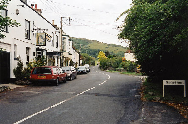
Weare is a small village located in the county of Somerset, England. Situated approximately 8 miles south of the town of Bridgwater, Weare is nestled in the picturesque countryside of the Somerset Levels. The village is set along the A38 road, providing convenient access to nearby towns and cities.

Weare has a rich history dating back to the Norman period, with evidence of settlement in the area since at least the 11th century. The village is known for its charming architecture, with many traditional thatched cottages and historic buildings still standing. The beautiful St. Gregory's Church, dating back to the 13th century, is a prominent landmark in the village.

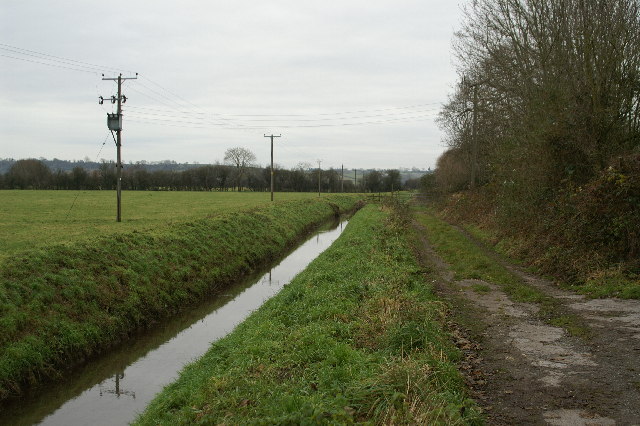
Despite its small size, Weare offers a range of amenities to its residents and visitors. The village has a primary school, a village hall, and a local pub, providing a sense of community and social gathering spaces. The surrounding countryside offers opportunities for outdoor activities such as walking, cycling, and fishing, with the River Axe flowing nearby.

Weare is also conveniently located near several tourist attractions, including the renowned Cheddar Gorge and Wookey Hole Caves, both within a short drive. The city of Bristol is approximately 20 miles away, offering a wide range of cultural, shopping, and entertainment opportunities.

Overall, Weare is a peaceful and charming village that offers a tranquil escape in the heart of Somerset's countryside, while still providing easy access to nearby towns and attractions.

If you have any feedback on the listing, please let us know in the comments section below.

Weare Images

Images are sourced within 2km of 51.269488/-2.8401277 or Grid Reference ST4152. Thanks to Geograph Open Source API. All images are credited.

Badgworth, Somerset The church of St Congar.
Badgworth, Somerset
The church of St Congar.
Compton Bishop: Cross Cross was a key posting station in coaching days. Two inns survive – the White Hart, seen here, and the New Inn. The White Hart, but probably not this structure, was extant at the time of the Monmouth Rebellion in 1685 and the subsequent ‘Bloody Assizes’ and the inn is said to be haunted by one of Judge Jefferies’ victims. The A38 trunk road now bypasses the village
Compton Bishop: Cross
Cross was a key posting station in coaching days. Two inns survive – the White Hart, seen here, and the New Inn. The White Hart, but probably not this structure, was extant at the time of the Monmouth Rebellion in 1685 and the subsequent ‘Bloody Assizes’ and the inn is said to be haunted by one of Judge Jefferies’ victims. The A38 trunk road now bypasses the village
WEARE, Somerset The church of St Gregory taken with yours truly standing alongside the grave of the comedian Frankie Howard (not shown).
WEARE, Somerset
The church of St Gregory taken with yours truly standing alongside the grave of the comedian Frankie Howard (not shown).
Cheddar Yeo near Cross This looks west along the arrow straight Cheddar Yeo, taken near the village of Cross.
Cheddar Yeo near Cross
This looks west along the arrow straight Cheddar Yeo, taken near the village of Cross.
BP Petrol Station
BP Petrol Station
Tanyard Farm Nurseries; Lower Weare
Notting Hill Day Nursery Part of the Bagworth Barns Industrial Units
Notting Hill Day Nursery
Part of the Bagworth Barns Industrial Units
Track through farm with the Mendips in the background
Mill House, near Stone Allerton
Farmyard machinery graveyard! Alston Sutton A field full of farming machinery some very rusty.
Farmyard machinery graveyard! Alston Sutton
A field full of farming machinery some very rusty.
Cottage Farm by Brinscombe Hill
Townsend Farm, Axbridge The newer farm buildings extends down onto the levels south of Axbridge, crossed here by the Cheddar Yeo and the Axe. Beyond is Weare.
Townsend Farm, Axbridge
The newer farm buildings extends down onto the levels south of Axbridge, crossed here by the Cheddar Yeo and the Axe. Beyond is Weare.
Cheddar Yeo The river, which starts life as Britain's biggest underground river, placidly flows across the levels between Axbridge and Weare. Seen from a bridge at Moorhouse Barn.
Cheddar Yeo
The river, which starts life as Britain's biggest underground river, placidly flows across the levels between Axbridge and Weare. Seen from a bridge at Moorhouse Barn.
The Lamb Inn, Lower Weare The Lamb is on Turnpike Road, the A38.
The Lamb Inn, Lower Weare
The Lamb is on Turnpike Road, the A38.
Sign for the Lamb Inn The lamb is of great Christian significance that to the passage in John 1:29 which reads "Behold the Lamb of God, which taketh away the sins of the world", thus equating the lamb with Jesus Christ. As a saintly emblem a lamb accompanies John the Baptist, St Agnes, St Catherine, St Genevieve and St Regina.
Sign for the Lamb Inn
The lamb is of great Christian significance that to the passage in John 1:29 which reads "Behold the Lamb of God, which taketh away the sins of the world", thus equating the lamb with Jesus Christ. As a saintly emblem a lamb accompanies John the Baptist, St Agnes, St Catherine, St Genevieve and St Regina.
Footpath, Lower Weare The footpath leaves the A38 to cross the area of lawn before joining the footpath beside the River Axe.
Footpath, Lower Weare
The footpath leaves the A38 to cross the area of lawn before joining the footpath beside the River Axe.
The A38 approaches Lower Weare
Show me another place!

Weare is located at Grid Ref: ST4152 (Lat: 51.269488, Lng: -2.8401277)

Administrative County: Somerset

District: Sedgemoor

Police Authority: Avon and Somerset

What 3 Words

///swerving.kebabs.loyal. Near Axbridge, Somerset

Nearby Locations

Sparrow Hill Weare Weare

Related Wikis

Weare, Somerset

Weare is a village and civil parish in Somerset, England, on the River Axe, south of the Mendip Hills. Other settlements in the parish are the village...

Badgworth

Badgworth is a village and civil parish in Somerset, England, 2 miles (3.2 km) south west of Axbridge. According to the 2011 census it had a population...

Chapel Allerton, Somerset

Chapel Allerton is a village and civil parish, south of Cheddar in the English county of Somerset. The parish includes the hamlets of Ashton and Stone...
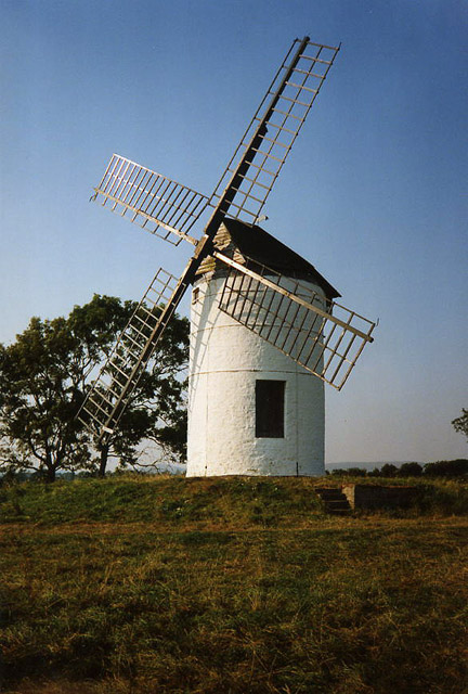
Ashton Windmill

Ashton windmill is a tower mill in Chapel Allerton, Somerset, England. Its tower is over 7.5 metres (25 ft) high with stone walls that are 60 cm (2.0 ft...

Nearby Amenities

Located within 500m of 51.269488,-2.8401277
Weare
Place: village
Source: npe
Lat/Long: 51.2706151/-2.842686
The data included in this document is from www.openstreetmap.org. The data is made available under ODbL.

Have you been to Weare?

Leave your review of Weare below (or comments, questions and feedback).