Watendlath

Settlement in Cumberland Allerdale

England

Watendlath

Stone laid path with clumps of heather The path has risen from Watendlath and continues to the summit of High Tove, though not in the well-constructed form seen in the image. The heather, (Calluna vulgaris), is at the peak of its flowering.
Stone laid path with clumps of heather Credit: Trevor Littlewood

Watendlath is a picturesque hamlet located in the Lake District National Park, in the county of Cumberland, England. Situated about 8 miles south of Keswick, it is nestled in a secluded valley near the famous Borrowdale Valley.

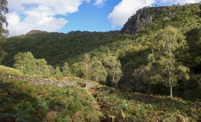
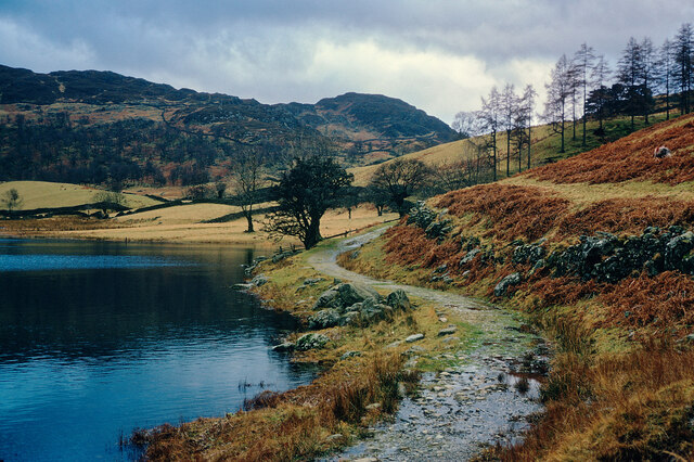
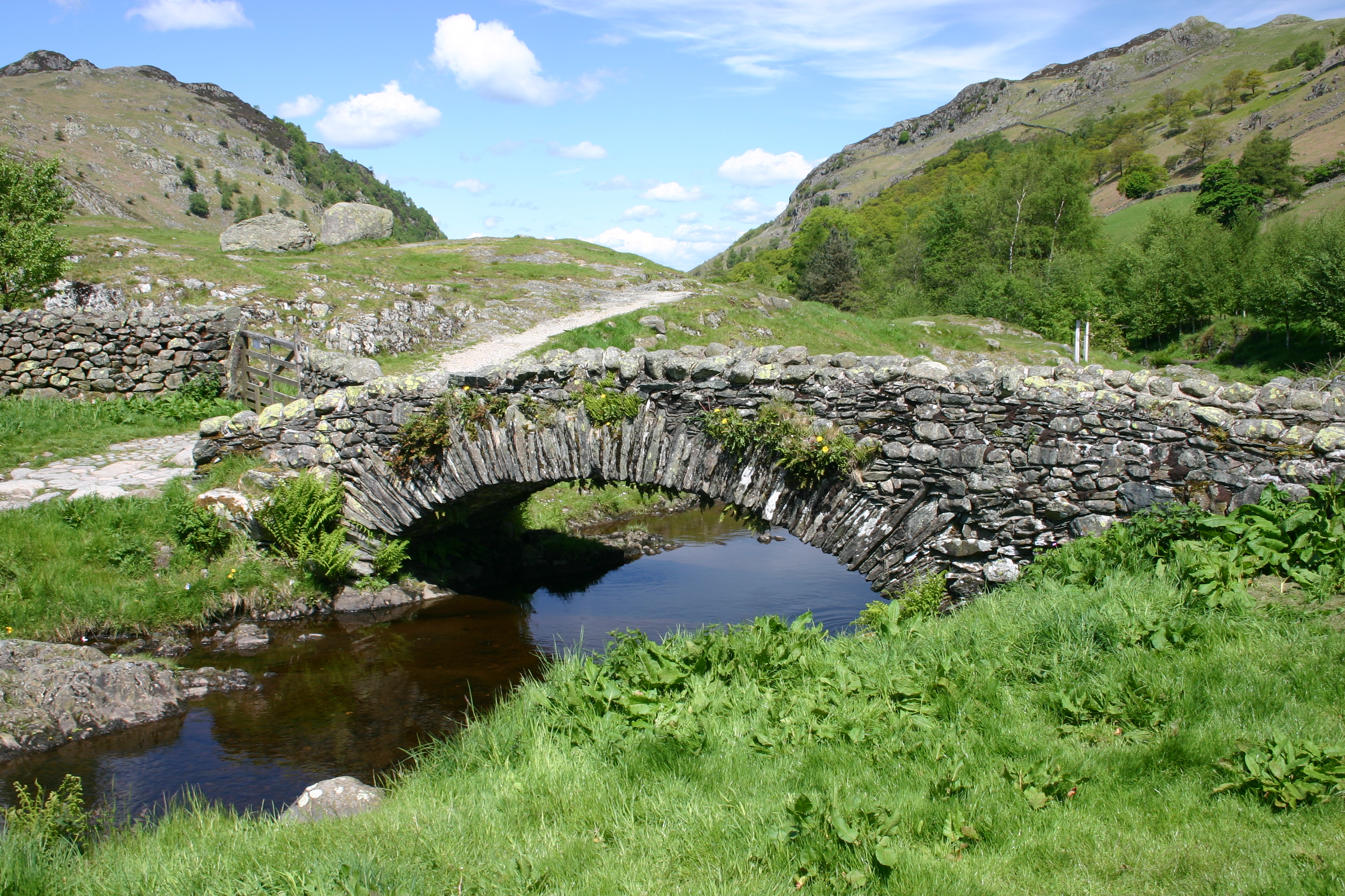
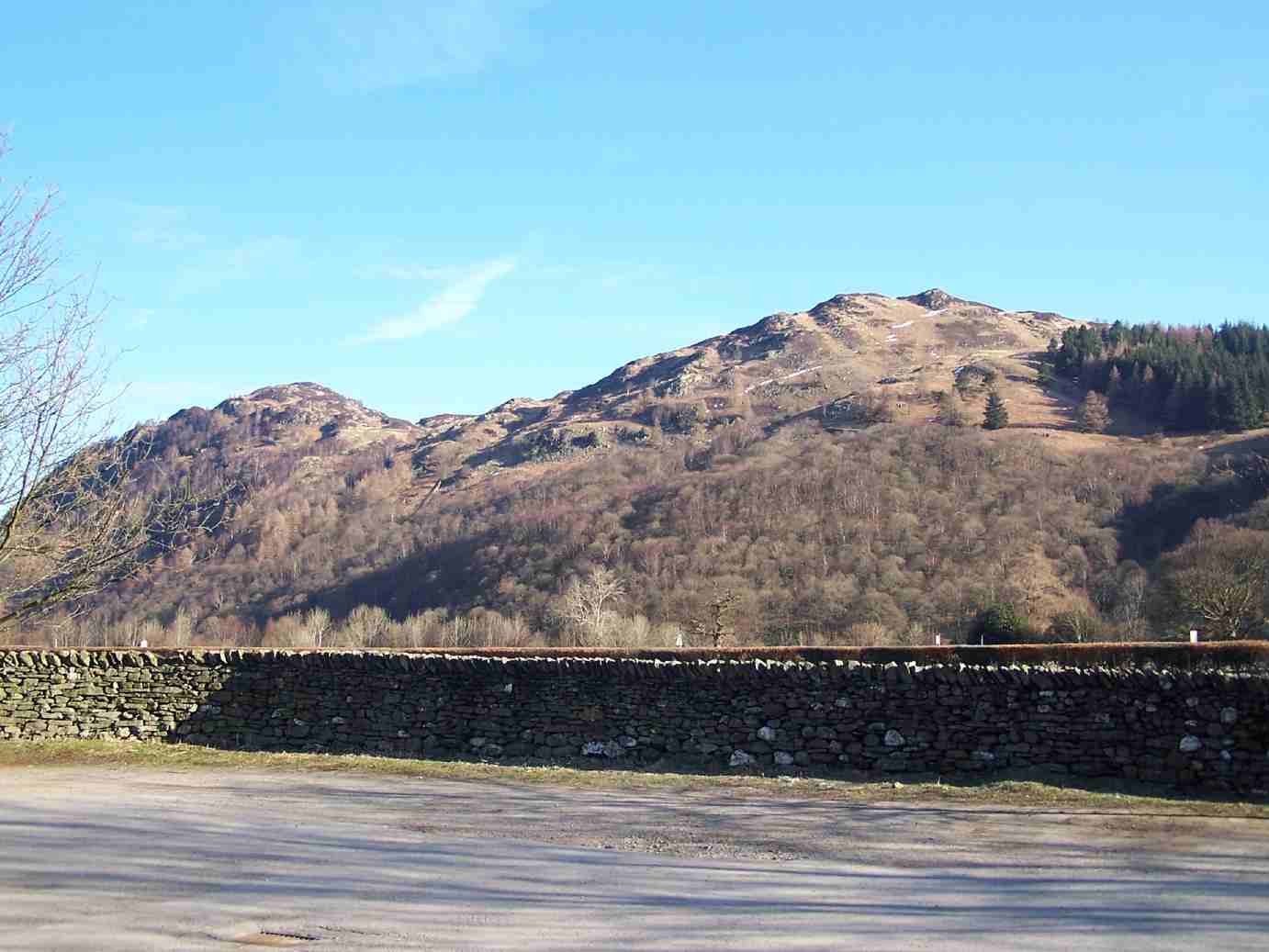
The hamlet is known for its stunning natural beauty and tranquil atmosphere. Surrounded by lush green meadows, dense woodlands, and towering mountains, Watendlath offers a breath-taking panorama of the surrounding landscape. It is particularly renowned for its captivating tarn, a small mountain lake, which adds to the charm of the area.

The settlement itself is comprised of a handful of traditional stone-built cottages, giving it a quintessential English countryside feel. These cottages are mostly used as holiday homes or let out to visitors seeking a peaceful retreat in the heart of nature. The hamlet also boasts a charming tea room, where visitors can enjoy a warm cup of tea or indulge in some homemade cakes while taking in the scenic views.

Watendlath is a haven for outdoor enthusiasts, offering a range of activities such as hiking, cycling, and fishing. Several walking trails lead from the hamlet, including the popular Watendlath Tarn Trail, which takes visitors on a leisurely stroll around the tarn. The area is also home to an abundance of wildlife, including red squirrels, deer, and a variety of bird species.

Overall, Watendlath is a hidden gem in the Lake District, providing a peaceful and idyllic escape for those seeking natural beauty and tranquility.

If you have any feedback on the listing, please let us know in the comments section below.

Watendlath Images

Images are sourced within 2km of 54.537004/-3.1205386 or Grid Reference NY2716. Thanks to Geograph Open Source API. All images are credited.

Stone laid path with clumps of heather The path has risen from Watendlath and continues to the summit of High Tove, though not in the well-constructed form seen in the image. The heather, (Calluna vulgaris), is at the peak of its flowering.
Stone laid path with clumps of heather
The path has risen from Watendlath and continues to the summit of High Tove, though not in the well-constructed form seen in the image. The heather, (Calluna vulgaris), is at the peak of its flowering.
Watendlath, 1987 From across the tarn.
Watendlath, 1987
From across the tarn.
Wall with gap in Troutdale Troutdale is a minor side valley in Borrowdale. The gap in the wall presumably was once sealable by a gate; a bridleway passes through there now.
Wall with gap in Troutdale
Troutdale is a minor side valley in Borrowdale. The gap in the wall presumably was once sealable by a gate; a bridleway passes through there now.
Rocky knolls of Brund Fell Brund Fell, the main summit of Grange Fell has a number of features similar to these knolls including the highest point itself. The knolls in the image lie south-east from the summit. High Seat is the shadowed hill in the distance.
Rocky knolls of Brund Fell
Brund Fell, the main summit of Grange Fell has a number of features similar to these knolls including the highest point itself. The knolls in the image lie south-east from the summit. High Seat is the shadowed hill in the distance.
Rock outcrops on Brund Fell Multiple rock outcrops to the west of the summit area of Brund Fell which is the highest area of Grange Fell.
In the distance the pointed hill near to the centre of the image is Dale Head; nearer and to the right of it, is High Spy.
Rock outcrops on Brund Fell
Multiple rock outcrops to the west of the summit area of Brund Fell which is the highest area of Grange Fell. In the distance the pointed hill near to the centre of the image is Dale Head; nearer and to the right of it, is High Spy.
Watendlath
Watendlath
By heck — a double heck Explanation: a 'heck' is a Cumbrian water-gate.
By heck — a double heck
Explanation: a 'heck' is a Cumbrian water-gate.
Outflow from Watendlath Tarn, above Borrowdale Clear sky, ancient footbridge and the beauty of the Lake District combined
Outflow from Watendlath Tarn, above Borrowdale
Clear sky, ancient footbridge and the beauty of the Lake District combined
Watendlath Tarn With the famous white ducks.
Watendlath Tarn
With the famous white ducks.
Brightly lit rocks of knoll The knoll is one of the features of the higher part of Great Crag above Rosthwaite, in Borrowdale.
Dale Head is the conical peak at the centre of the horizon.
Brightly lit rocks of knoll
The knoll is one of the features of the higher part of Great Crag above Rosthwaite, in Borrowdale. Dale Head is the conical peak at the centre of the horizon.
Footbridge overhung by tree branches Watendlath Beck is descending below the footbridge.
Footbridge overhung by tree branches
Watendlath Beck is descending below the footbridge.
View to Rosthwaite from the path to Watendlath A fine view including the prominent white building in Rosthwaite, the Guest House in which we were staying
View to Rosthwaite from the path to Watendlath
A fine view including the prominent white building in Rosthwaite, the Guest House in which we were staying
Approaching Watendlath on the path from Borrowdale A small hamlet that is most enjoyably approached on foot from Rosthwaite.
Approaching Watendlath on the path from Borrowdale
A small hamlet that is most enjoyably approached on foot from Rosthwaite.
Rosthwaite and Borrowdale from the path to Watendlath A fine view at any season of the year. See <a href="https://www.geograph.org.uk/photo/7352979">NY2615 : View to Rosthwaite from the path to Watendlath</a> for an Easter view.
Rosthwaite and Borrowdale from the path to Watendlath
A fine view at any season of the year. See NY2615 : View to Rosthwaite from the path to Watendlath for an Easter view.
Path by Watendlath Tarn A good destination for a walk from Rosthwaite in Borrowdale.
Path by Watendlath Tarn
A good destination for a walk from Rosthwaite in Borrowdale.
Rocks beside Watendlath Beck A stretch of the beck below Reecastle Crag which is out of the image, high above the valley, to the right.
Rocks beside Watendlath Beck
A stretch of the beck below Reecastle Crag which is out of the image, high above the valley, to the right.
Joppelty How Joppelty How is the obvious rock peak at the left side of the image; it's an outcrop on Brund Fell, itself part of Grange Fell.
High Seat is in the distance at the centre of the horizon.
Joppelty How
Joppelty How is the obvious rock peak at the left side of the image; it's an outcrop on Brund Fell, itself part of Grange Fell. High Seat is in the distance at the centre of the horizon.
Watendlath Tarn The tarn from near to a path junction at its northern end.
The distant upland rises ultimately to Ullscarf.
Watendlath Tarn
The tarn from near to a path junction at its northern end. The distant upland rises ultimately to Ullscarf.
Show me another place!

Watendlath is located at Grid Ref: NY2716 (Lat: 54.537004, Lng: -3.1205386)

Administrative County: Cumbria

District: Allerdale

Police Authority: Cumbria

What 3 Words

///mining.visions.northward. Near Keswick, Cumbria

Nearby Locations

Watendlath Tarn Watendlath

Related Wikis

Watendlath

Watendlath is a hamlet and tarn (a small lake) in the Lake District in the English county of Cumbria, historically part of Cumberland, Watendlath is owned...

Grange Fell

Grange Fell is a small fell in the English Lake District in the county of Cumbria, situated in the Borrowdale valley overlooking the villages of Grange...

High Tove

High Tove is a fell in the English Lake District, close to the geographical centre of the Cumbrian hills. It forms part of the watershed between the Derwentwater...

Bell Crags

Bell Crags (also known as Long Moss or Blea Tarn Fell) is a hill of 559.1 metres (1,834 ft) in the Lake District, England. It lies between Borrowdale...

Nearby Amenities

Located within 500m of 54.537004,-3.1205386
Source: npe
Lat/Long: 54.5366123/-3.1218799
Source: npe
Lat/Long: 54.5368174/-3.1216505
Source: npe
Lat/Long: 54.5363439/-3.1217173
Source: npe
Lat/Long: 54.53594/-3.1207649
Source: npe
Lat/Long: 54.5357685/-3.1204495
Source: npe
Lat/Long: 54.5342331/-3.1204394
Source: npe
Lat/Long: 54.5338707/-3.1207354
Source: npe
Lat/Long: 54.5338484/-3.1213013
Source: npe
Lat/Long: 54.5340752/-3.1217745
Source: npe
Lat/Long: 54.5342896/-3.1221163
Source: npe
Lat/Long: 54.5343742/-3.1224216
Source: npe
Lat/Long: 54.534649/-3.1226188
Source: npe
Lat/Long: 54.5350436/-3.1231896
Source: npe
Lat/Long: 54.5355998/-3.1229615
Source: npe
Lat/Long: 54.5361968/-3.1226921
Watendlath
Place: hamlet
Source: npe
Wikidata: Q2552486
Wikipedia: en:Watendlath
Lat/Long: 54.5370111/-3.1210593
Toilets
Access: yes
Toilets Disposal: flush
Unisex: yes
Wheelchair: yes
Lat/Long: 54.5368535/-3.1206699
Caffle House Tea Rooms
Local Ref: AT
Naptan AtcoCode: 090002111264
Naptan Bearing: N
Naptan BusStopType: CUS
Naptan CommonName: Caffle House Tea Rooms
Naptan Indicator: at
Naptan Landmark: Watendlath Farm NT property
Naptan NaptanCode: cumadamw
Naptan Street: No name
Naptan Verified: no
Source: naptan_import
Lat/Long: 54.536576/-3.1207842
Cafe
Caffle House Tea Room
Addr City: Watendlath
Addr Housename: Caffle House
Addr Postcode: CA12 5UW
Fhrs Id: 267352
Lat/Long: 54.536949/-3.1208358
Ford: yes
Lat/Long: 54.5399969/-3.1259915
Source: survey
Lat/Long: 54.5380597/-3.1244753
Barrier: kissing_gate
Source: gps
Lat/Long: 54.53668/-3.1244056
Black Waugh
Place: locality
Lat/Long: 54.5373908/-3.1254071
Bracken Platt
Place: locality
Lat/Long: 54.5347504/-3.1247339
Rough Knott
Place: locality
Lat/Long: 54.5352619/-3.1142051
Source: survey
Lat/Long: 54.5354863/-3.1232972
Bicycle Parking
Bicycle Parking: stands
Lat/Long: 54.5369498/-3.1204571
Vending Machine
Vending: parking_tickets
Lat/Long: 54.5367346/-3.120614
Ford: yes
Lat/Long: 54.5388539/-3.1254645
Ford: yes
Lat/Long: 54.5345097/-3.1239032
Ford: yes
Lat/Long: 54.5373007/-3.1147565
Ford: yes
Lat/Long: 54.5371273/-3.1191983
Ford: yes
Lat/Long: 54.5367515/-3.1217012
The data included in this document is from www.openstreetmap.org. The data is made available under ODbL.

Have you been to Watendlath?

Leave your review of Watendlath below (or comments, questions and feedback).