Warter

Settlement in Yorkshire

England

Warter

Manor Farm House, Warter On the B1246.
Manor Farm House, Warter Credit: JThomas

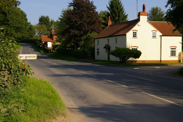
Warter is a picturesque village located in the East Riding of Yorkshire, England. Situated approximately seven miles east of Pocklington, it is nestled amidst the rolling hills of the Yorkshire Wolds. The village has a population of around 350 residents, creating a close-knit community atmosphere.

One of Warter's most notable features is Warter Priory, a stunning Grade I listed country house. Built in the 18th century, the house is set within a sprawling estate, complete with beautiful gardens and a lake. The priory is privately owned and not open to the public, but its grandeur can still be admired from a distance.

The village itself boasts charming stone cottages, a village hall, and a local pub, providing a hub for socializing and community gatherings. Agriculture plays a significant role in the local economy, with several farms dotting the surrounding countryside.

For nature enthusiasts, Warter offers a wealth of outdoor activities. The village is surrounded by scenic walking trails, allowing visitors to explore the stunning landscapes of the Yorkshire Wolds. Additionally, the nearby Warter Woods and Warter Wold nature reserve provide opportunities for birdwatching and wildlife spotting.

Despite its small size, Warter enjoys a rich historical heritage. The local church, St. James' Church, is a Grade I listed building with parts dating back to the 11th century. Its architecture showcases a blend of Norman and Gothic styles, making it a fascinating place to visit for history buffs.

Overall, Warter is a tranquil and idyllic village, offering a glimpse into the beauty of rural Yorkshire.

If you have any feedback on the listing, please let us know in the comments section below.

Warter Images

Images are sourced within 2km of 53.942282/-0.67934324 or Grid Reference SE8650. Thanks to Geograph Open Source API. All images are credited.

Manor Farm House, Warter On the B1246.
Manor Farm House, Warter
On the B1246.
K6 telephone box on the B1246, Warter Outside the former Post Office.
Manor Farm House on the left <a href="https://www.geograph.org.uk/photo/7046534">SE8650 : Manor Farm House, Warter</a>.
K6 telephone box on the B1246, Warter
Outside the former Post Office. Manor Farm House on the left SE8650 : Manor Farm House, Warter.
B1246, Warter Towards Pocklington.
B1246, Warter
Towards Pocklington.
War Memorial on Cross Green, Warter Ludhill Farm behind.
War Memorial on Cross Green, Warter
Ludhill Farm behind.
Fingerpost on minor road junction, Warter
George VI postbox on the B1246, Warter On the former Post Office.
Postbox No. YO42 140.

See <a href="https://www.geograph.org.uk/photo/7046571">SE8650 : Former Post Office, Warter</a> and <a href="https://www.geograph.org.uk/photo/7046573">SE8650 : Former Post Office, Warter</a> for context.
George VI postbox on the B1246, Warter
On the former Post Office. Postbox No. YO42 140. See SE8650 : Former Post Office, Warter and SE8650 : Former Post Office, Warter for context.
Former Post Office, Warter On the B1246.
Showing position of Postbox No. YO42 140.

See <a href="https://www.geograph.org.uk/photo/7046569">SE8650 : George VI postbox on the B1246, Warter</a> for postbox.
Former Post Office, Warter
On the B1246. Showing position of Postbox No. YO42 140. See SE8650 : George VI postbox on the B1246, Warter for postbox.
House on Inrea Hill (B1246)
Inrea Hill (B1246) Towards Warter.
Inrea Hill (B1246)
Towards Warter.
House, Westbeck Hill
Cottage, Westbeck Hill
Westbeck Hill (B1246) Towards Warter.
Westbeck Hill (B1246)
Towards Warter.
Entering Warter On the B1246.
Entering Warter
On the B1246.
Farm buildings, Skygate Farm
Skygate Farm, Warter
Cottages, Warter
Cottages, Warter
Former Post Office, Warter
Show me another place!

Warter is located at Grid Ref: SE8650 (Lat: 53.942282, Lng: -0.67934324)

Division: East Riding

Unitary Authority: East Riding of Yorkshire

Police Authority: Humberside

What 3 Words

///aura.trials.conspire. Near Millington, East Yorkshire

Related Wikis

Warter

Warter is a small village and civil parish in the East Riding of Yorkshire, England. It is situated approximately 4 miles (6.4 km) east of Pocklington...

St James' Church, Warter

St James’ Church lies in Warter, an estate village in England, in the Yorkshire Wolds, part of the East Riding of Yorkshire. == Origins and history... ==

Warter Priory

Warter Priory is an 11,000 acres (4,500 ha) country estate in the East Riding of Yorkshire Yorkshire Wolds, centred 1 mile (2 km) south-west of the village...

Nunburnholme Priory

Nunburnholme Priory was a priory of Benedictine nuns in the East Riding of Yorkshire, England. It was founded during the reign of Henry II of England by...

Nearby Amenities

Located within 500m of 53.942282,-0.67934324
Warter
Place: village
Lat/Long: 53.9423769/-0.6771917
Historic: monument
Lat/Long: 53.9420414/-0.6771531
Bus Stop
Warter B1246
Naptan AtcoCode: 2200YEA01036
Naptan Bearing: W
Naptan CommonName: Warter B1246
Naptan Crossing: Addlekeld
Naptan Indicator: Adj
Naptan Landmark: War Memorial
Naptan Street: B1246
Naptan Verified: no
Source: naptan_import
Lat/Long: 53.9419966/-0.6775074
Bus Stop
Warter Addlekeld
Naptan AtcoCode: 2200YEA01041
Naptan Bearing: S
Naptan CommonName: Warter Addlekeld
Naptan Street: Addlekeld
Naptan Verified: no
Source: naptan_import
Lat/Long: 53.9406635/-0.6780676
Telephone
Booth: K6
Covered: booth
Man Made: telephone_box
Lat/Long: 53.9421573/-0.6783244
Post Box
Collection Times: Mo-Fr 16:00; Sa 10:15
Post Box Type: wall
Ref: YO42 140
Royal Cypher: GVIR
Royal Cypher Wikidata: Q33102169
Lat/Long: 53.9421369/-0.678416
Material: wood
Power: pole
Lat/Long: 53.9452807/-0.6832048
Material: wood
Power: pole
Lat/Long: 53.9446894/-0.6822291
Material: wood
Power: pole
Lat/Long: 53.9443066/-0.6811482
Material: wood
Power: pole
Lat/Long: 53.9442454/-0.6809831
Line Management: termination
Material: wood
Power: pole
Lat/Long: 53.9441727/-0.6807622
Material: wood
Power: pole
Lat/Long: 53.9441848/-0.6814121
Material: wood
Power: pole
Lat/Long: 53.943687/-0.682486
Material: wood
Power: pole
Lat/Long: 53.9431895/-0.6836168
Material: wood
Power: pole
Lat/Long: 53.9426952/-0.6846766
Material: wood
Power: pole
Lat/Long: 53.9422062/-0.6857721
Material: wood
Power: pole
Lat/Long: 53.9417735/-0.6867067
Line Management: branch
Material: wood
Power: pole
Lat/Long: 53.9415473/-0.6747043
Material: wood
Power: pole
Lat/Long: 53.941592/-0.6743324
Line Management: termination
Material: wood
Power: pole
Transformer: distribution
Lat/Long: 53.9414367/-0.6757059
Material: wood
Power: pole
Lat/Long: 53.9417673/-0.6727851
Material: wood
Power: pole
Lat/Long: 53.9409508/-0.6756054
Material: wood
Power: pole
Lat/Long: 53.9405278/-0.6762078
Material: wood
Power: pole
Lat/Long: 53.9399554/-0.6771137
Material: wood
Power: pole
Lat/Long: 53.9394703/-0.6778581
Line Management: termination
Material: wood
Power: pole
Transformer: distribution
Lat/Long: 53.9398806/-0.6780905
Material: wood
Power: pole
Lat/Long: 53.9388357/-0.6788177
Material: wood
Power: pole
Lat/Long: 53.9380999/-0.6794976
The data included in this document is from www.openstreetmap.org. The data is made available under ODbL.

Have you been to Warter?

Leave your review of Warter below (or comments, questions and feedback).