Turkdean

Settlement in Gloucestershire Cotswold

England

Turkdean

Lane north of Hampnett Followed by the Diamond Way and the Macmillan Way. Ahead are trees along the A40.
Lane north of Hampnett Credit: Derek Harper

Turkdean is a small village located in the county of Gloucestershire, England. Situated in the picturesque Cotswolds region, this rural village is surrounded by rolling hills, meadows, and quaint countryside scenery. It is part of the Cotswold District and lies approximately 6 miles southwest of the market town of Stow-on-the-Wold.

With its origins dating back to medieval times, Turkdean is rich in history and retains much of its traditional charm. The village is home to a cluster of stone-built cottages, many of which date back several centuries. These buildings showcase the architectural style of the region, with their distinctive honey-colored Cotswold stone exteriors and thatched roofs.

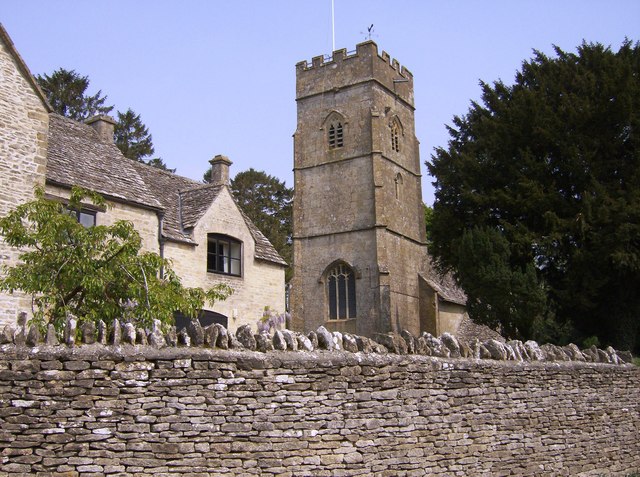
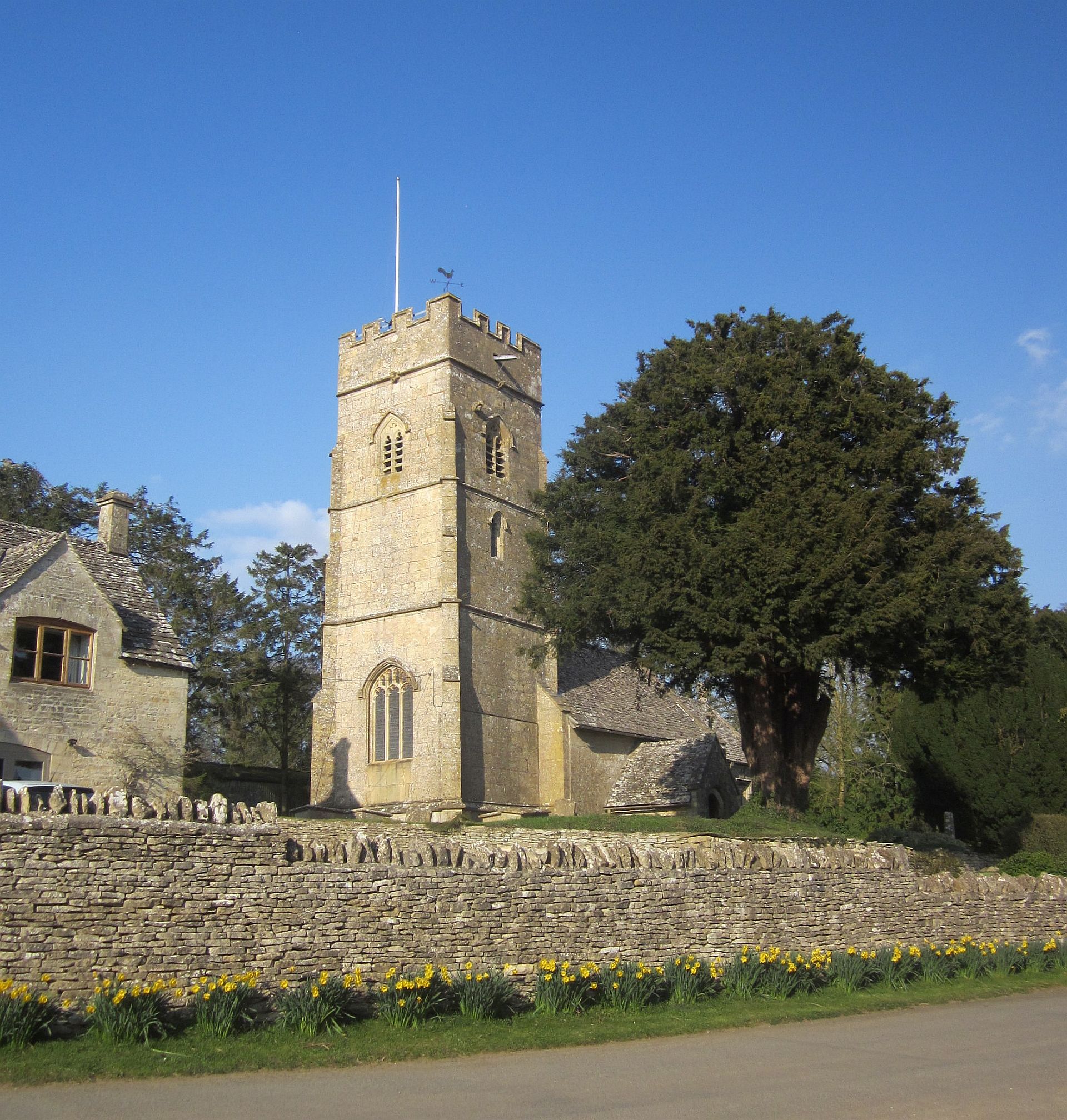
Despite its small size, Turkdean boasts a close-knit community and a thriving village spirit. It has a local church, St. Nicholas, which is a Grade II listed building and a prominent landmark in the area. The church, with its beautiful stained glass windows and ancient bell tower, is a testament to the village's historical significance.

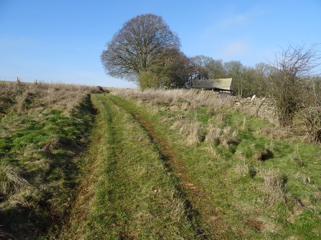
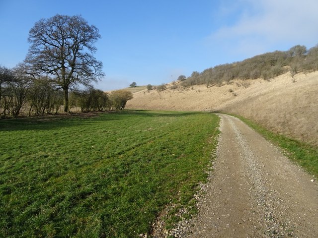
The surrounding countryside offers an abundance of outdoor activities, making Turkdean an attractive destination for nature lovers and hikers. The village is located near several walking trails, including the popular Cotswold Way, which offers stunning views of the rolling hills and valleys.

Overall, Turkdean is a tranquil and picturesque village that offers a peaceful retreat for those seeking a quintessential English countryside experience. Its historical charm, natural beauty, and sense of community make it a hidden gem within the Cotswolds.

If you have any feedback on the listing, please let us know in the comments section below.

Turkdean Images

Images are sourced within 2km of 51.857123/-1.845066 or Grid Reference SP1017. Thanks to Geograph Open Source API. All images are credited.

Lane north of Hampnett Followed by the Diamond Way and the Macmillan Way. Ahead are trees along the A40.
Lane north of Hampnett
Followed by the Diamond Way and the Macmillan Way. Ahead are trees along the A40.
Crop, Hampnett A brassica crop by the lane shown in <a href="https://www.geograph.org.uk/photo/4662695">SP0916 : Lane north of Hampnett</a>. Across the field are trees along the A40; you can make out a roadsign and a lorry (right).
Crop, Hampnett
A brassica crop by the lane shown in SP0916 : Lane north of Hampnett. Across the field are trees along the A40; you can make out a roadsign and a lorry (right).
Track, Hampnett Along the north edge of the village - not a public right of way although seen from the road carrying the Diamond Way and the Macmillan Way.
Track, Hampnett
Along the north edge of the village - not a public right of way although seen from the road carrying the Diamond Way and the Macmillan Way.
Hampnett From the lane entering the village from the north, looking down the green.
Hampnett
From the lane entering the village from the north, looking down the green.
Hampnett Taken a little further down the lane shown in <a href="https://www.geograph.org.uk/photo/4662743">SP0915 : Hampnett</a>, showing The Crooked House, which bears the date 1799 <span class="nowrap"><a title="http://www.britishlistedbuildings.co.uk/en-130036-the-crooked-house-hampnett-gloucestershi" rel="nofollow ugc noopener" href="http://www.britishlistedbuildings.co.uk/en-130036-the-crooked-house-hampnett-gloucestershi">Link</a><img style="margin-left:2px;" alt="External link" title="External link - shift click to open in new window" src="https://s1.geograph.org.uk/img/external.png" width="10" height="10"/></span> , on the left.
Hampnett
Taken a little further down the lane shown in SP0915 : Hampnett, showing The Crooked House, which bears the date 1799 LinkExternal link , on the left.
Downs Barn 13 years after my first visit I first photographed this barn in December 2005 <a href="https://www.geograph.org.uk/photo/92993">SP0918 : Downs Barn</a>, returning again eight years later in December 2013 <a href="https://www.geograph.org.uk/photo/3793483">SP0918 : Downs Barn</a>.  Here is the same scene again just over five years later in February 2019, recording further dilapidation with the roof in a greater state of collapse.  The beech trees are still there however a pile of local stone has appeared since my last visit.  I commented in December 2013 I was surprised that one else had visited this grid square, I am even more so now, almost fourteen years since the founding of the Geograph website and still no one else other than me has recorded this square.
Downs Barn 13 years after my first visit
I first photographed this barn in December 2005 SP0918 : Downs Barn, returning again eight years later in December 2013 SP0918 : Downs Barn. Here is the same scene again just over five years later in February 2019, recording further dilapidation with the roof in a greater state of collapse. The beech trees are still there however a pile of local stone has appeared since my last visit. I commented in December 2013 I was surprised that one else had visited this grid square, I am even more so now, almost fourteen years since the founding of the Geograph website and still no one else other than me has recorded this square.
Downs Barn I first photographed this barn in December 2005 <a href="https://www.geograph.org.uk/photo/92993">SP0918 : Downs Barn</a>, returning again eight years later in December 2013.  Here is the same scene again just over five years later in February 2019, recording further dilapidation with the roof in a greater state of collapse.
Downs Barn
I first photographed this barn in December 2005 SP0918 : Downs Barn, returning again eight years later in December 2013. Here is the same scene again just over five years later in February 2019, recording further dilapidation with the roof in a greater state of collapse.
Downs Barn Downs Barn viewed from the south, I have photographed these barns for the last fourteen years, they appear neglected and deteriorating.
Downs Barn
Downs Barn viewed from the south, I have photographed these barns for the last fourteen years, they appear neglected and deteriorating.
Footpath passing Downs Barn Footpath and track passing Downs Barn in a Cotswold valley.
Footpath passing Downs Barn
Footpath and track passing Downs Barn in a Cotswold valley.
Track approaching Downs Barn A track climbing out of a Cotswold valley and approaching Downs Barn which is just visible on the right.
Track approaching Downs Barn
A track climbing out of a Cotswold valley and approaching Downs Barn which is just visible on the right.
Game cover This field headland strip in a Cotswold valley is probably planted to provide cover for game birds.
Game cover
This field headland strip in a Cotswold valley is probably planted to provide cover for game birds.
Valley bottom track Track in a valley near Turkdean.  This track has been laid since I last walked this valley just over five years ago.
Valley bottom track
Track in a valley near Turkdean. This track has been laid since I last walked this valley just over five years ago.
Track in a valley bottom Track in a valley bottom near the village of Turkdean.  This track has been laid since I last walked this valley just over five years ago.
Track in a valley bottom
Track in a valley bottom near the village of Turkdean. This track has been laid since I last walked this valley just over five years ago.
Track and horse jump Track and horse jump in a valley near Turkdean.
Track and horse jump
Track and horse jump in a valley near Turkdean.
Track and footpath Track and footpath through a valley near Turkdean.  Stone has been laid on this track since I last walked it just over five years ago <a href="https://www.geograph.org.uk/photo/3793523">SP0917 : Track in a Cotswold valley</a>.
Track and footpath
Track and footpath through a valley near Turkdean. Stone has been laid on this track since I last walked it just over five years ago SP0917 : Track in a Cotswold valley.
Track and a footpath Track and a footpath in a Cotswold valley near Turkdean.  The same view as December 2013 <a href="https://www.geograph.org.uk/photo/3816246">SP0917 : Cotswold valley</a> when I last walked this valley, since then the track has been relaid.
Track and a footpath
Track and a footpath in a Cotswold valley near Turkdean. The same view as December 2013 SP0917 : Cotswold valley when I last walked this valley, since then the track has been relaid.
Cotswold : The A40 Looking along the A40.
Cotswold : The A40
Looking along the A40.
Cotswold : Road Looking along a road off the A40.
Cotswold : Road
Looking along a road off the A40.
Show me another place!

Turkdean is located at Grid Ref: SP1017 (Lat: 51.857123, Lng: -1.845066)

Administrative County: Gloucestershire

District: Cotswold

Police Authority: Gloucestershire

What 3 Words

///skyrocket.hardens.seats. Near Northleach, Gloucestershire

Related Wikis

Turkdean

Turkdean is a village and civil parish in Gloucestershire, England, approximately 30 km (19 mi) to the east of Gloucester. It lies in the Cotswolds, an...

Church of All Saints, Turkdean

The Anglican Church of All Saints at Turkdean in the Cotswold District of Gloucestershire, England was built in the 12th century. It is a grade I listed...

Hampnett

Hampnett is a small village and civil parish in Gloucestershire, England, just west of the Fosse Way. It is situated west of the junction of the A40 and...

Church of St George, Hampnett

The Anglican Church of St George at Hampnett in the Cotswold District of Gloucestershire, England was built in 12th century. It is a grade I listed building...

Nearby Amenities

Located within 500m of 51.857123,-1.845066
Turkdean
Is In: Gloucestershire, England, UK
Place: village
Lat/Long: 51.856573/-1.8458473
Bus Stop
All Saints' Church
Bus: yes
Naptan AtcoCode: 1600GL4908
Naptan Bearing: SW
Naptan CommonName: All Saints' Church
Naptan NaptanCode: glogdgwa
Naptan Street: Main Street
Naptan Verified: no
Public Transport: platform
Source: naptan_import
Lat/Long: 51.8557286/-1.8454213
Bus Stop
Manor House
Bus: yes
Naptan AtcoCode: 1600GLC450
Naptan Bearing: SE
Naptan CommonName: Manor House
Naptan NaptanCode: glogdgwd
Naptan Street: Notgrove Ln
Naptan Verified: no
Public Transport: platform
Source: naptan_import
Lat/Long: 51.8572926/-1.845082
Bus Stop
Bus: yes
Public Transport: platform
Source: survey
Lat/Long: 51.8577302/-1.8457416
Ford: yes
Lat/Long: 51.8543414/-1.8486387
Ford: yes
Lat/Long: 51.8542199/-1.8484877
HE Ref: 1089821
Description: UNIDENTIFIED MONUMENT
Historic: tomb
Listed Status: Grade II
Lat/Long: 51.8553976/-1.8453944
HE Ref: 1341093
Description: UNIDENTIFIED MONUMENT IN THE CHURCHYARD OF CHURCH OF ALL SAINTS CIRCA 9 METRES NORTH OF NORTH PORCH
Historic: tomb
Listed Status: Grade II
Lat/Long: 51.8553077/-1.8454093
HE Ref: 1039573
Description: UNIDENTIFIED MONUMENT IN THE CHURCHYARD OF CHURCH OF ALL SAINTS, CIRCA 1 METRE WEST OF SOUTH AISLE
Historic: tomb
Listed Status: Grade II
Lat/Long: 51.8550911/-1.8454777
Telephone
HE Ref: 1409334
Booth: K6
Covered: booth
Description: K6 Telephone Kiosk
Historic: yes
Listed Status: Grade II
Man Made: telephone_box
Operator: BT
Operator Wikidata: Q593786
Phone: +44 1451 860301
Lat/Long: 51.8557756/-1.8452547
Post Box
Post Box Type: wall
Lat/Long: 51.8553202/-1.8460836
The data included in this document is from www.openstreetmap.org. The data is made available under ODbL.

Have you been to Turkdean?

Leave your review of Turkdean below (or comments, questions and feedback).