Bottisham

Settlement in Cambridgeshire East Cambridgeshire

England

Bottisham

On Little Wilbraham Road in November The long narrow plantation marks the line of part of the main runway of Bottisham Airfield (1940-6), which at first had a grass runway. According to the American Air Museum in Britain website “The P-47 Thunderbolts of the 361st Fighter Group damaged the surfaces of the airfield so much in the first months of flying from Bottisham that American engineers were called in to lay a new runway. In January 1944 they constructed a 1,470-yard-long runway with pierced-steel planking in just three days”.

These images may be of interest: <a href="https://www.geograph.org.uk/photo/5991392">TL5458 : Little Wilbraham: a farm track with a history</a>, <a href="https://www.geograph.org.uk/photo/5610857">TL5460 : Restored buildings at Bottisham Airfield Museum</a> and <a href="https://www.geograph.org.uk/photo/5610851">TL5460 : The Stars and Stripes at Bottisham Airfield Museum</a>.
On Little Wilbraham Road in November Credit: John Sutton

Bottisham is a charming village located in Cambridgeshire, England. Situated approximately 8 miles east of Cambridge, it is nestled in the picturesque countryside of the county. With a population of around 2,500 residents, Bottisham retains a close-knit community feel.

The village is renowned for its historical significance, dating back to the Roman times. Evidence of this can be seen through the discovery of Roman pottery and coins in the area. Bottisham also played a key role during the medieval period, with the village being mentioned in the Domesday Book of 1086.

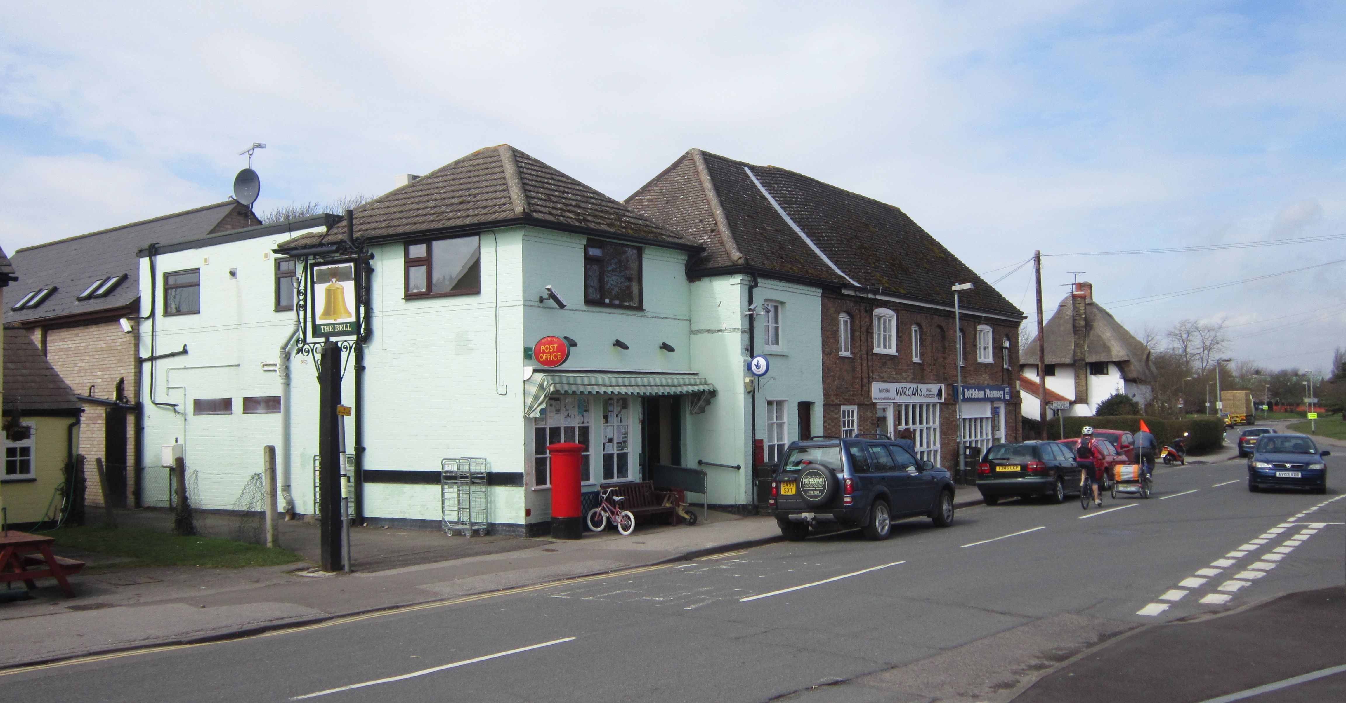
Today, Bottisham offers a range of amenities and services for its residents. The village has a primary school, which has received positive recognition for its academic achievements. Additionally, there are several local businesses, including a convenience store, a post office, and a pub, providing essential services and a sense of community.

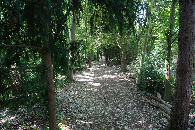
Nature lovers are drawn to Bottisham due to its proximity to beautiful green spaces. The village is surrounded by fields and farmland, making it an ideal location for peaceful walks and cycling. The nearby Lode Watermill and Nature Reserve is a popular spot for wildlife enthusiasts and offers stunning views of the local flora and fauna.

Overall, Bottisham provides a tranquil and idyllic setting for residents and visitors alike, with its rich history, close community, and beautiful natural surroundings.

If you have any feedback on the listing, please let us know in the comments section below.

Bottisham Images

Images are sourced within 2km of 52.223393/0.258185 or Grid Reference TL5460. Thanks to Geograph Open Source API. All images are credited.

On Little Wilbraham Road in November The long narrow plantation marks the line of part of the main runway of Bottisham Airfield (1940-6), which at first had a grass runway. According to the American Air Museum in Britain website “The P-47 Thunderbolts of the 361st Fighter Group damaged the surfaces of the airfield so much in the first months of flying from Bottisham that American engineers were called in to lay a new runway. In January 1944 they constructed a 1,470-yard-long runway with pierced-steel planking in just three days”.

These images may be of interest: <a href="https://www.geograph.org.uk/photo/5991392">TL5458 : Little Wilbraham: a farm track with a history</a>, <a href="https://www.geograph.org.uk/photo/5610857">TL5460 : Restored buildings at Bottisham Airfield Museum</a> and <a href="https://www.geograph.org.uk/photo/5610851">TL5460 : The Stars and Stripes at Bottisham Airfield Museum</a>.
On Little Wilbraham Road in November
The long narrow plantation marks the line of part of the main runway of Bottisham Airfield (1940-6), which at first had a grass runway. According to the American Air Museum in Britain website “The P-47 Thunderbolts of the 361st Fighter Group damaged the surfaces of the airfield so much in the first months of flying from Bottisham that American engineers were called in to lay a new runway. In January 1944 they constructed a 1,470-yard-long runway with pierced-steel planking in just three days”. These images may be of interest: TL5458 : Little Wilbraham: a farm track with a history, TL5460 : Restored buildings at Bottisham Airfield Museum and TL5460 : The Stars and Stripes at Bottisham Airfield Museum.
Jubilee Avenue, Anglesey Abbey Garden A tree lined walk, part of the National Trust garden at Anglesey Abbey.
Jubilee Avenue, Anglesey Abbey Garden
A tree lined walk, part of the National Trust garden at Anglesey Abbey.
Long Meadow: Haynes' Yard Haynes' Yard is the base for a number of businesses, including the Cambridge Tours coach-hire company.
Long Meadow: Haynes' Yard
Haynes' Yard is the base for a number of businesses, including the Cambridge Tours coach-hire company.
On the way to Lode This is the excellent cycle path beside Quy Road, photographed on a bright and blustery February morning. The concrete posts are boundary markers, which show where the local authority's obligations cease and the landowner's begin.
On the way to Lode
This is the excellent cycle path beside Quy Road, photographed on a bright and blustery February morning. The concrete posts are boundary markers, which show where the local authority's obligations cease and the landowner's begin.
Bottisham: a Mustang at the Airfield Museum The museum's website explains that it "was opened in 2009 to commemorate the sometimes forgotten role of the airfield at Bottisham in World War Two. It is the only UK museum dedicated to the Royal Air Force, United States 8th Army Air Force and Belgian Air Forces.  We are now operating out of the last remaining airfield buildings to exist within the airfield’s original perimeter."

For more about the restored P51 Mustang fighter, see <span class="nowrap"><a title="https://www.bottishamairfieldmuseum.org.uk/general/progress-on-the-bottisham-p51-mustang/" rel="nofollow ugc noopener" href="https://www.bottishamairfieldmuseum.org.uk/general/progress-on-the-bottisham-p51-mustang/">Link</a><img style="margin-left:2px;" alt="External link" title="External link - shift click to open in new window" src="https://s1.geograph.org.uk/img/external.png" width="10" height="10"/></span> .
Bottisham: a Mustang at the Airfield Museum
The museum's website explains that it "was opened in 2009 to commemorate the sometimes forgotten role of the airfield at Bottisham in World War Two. It is the only UK museum dedicated to the Royal Air Force, United States 8th Army Air Force and Belgian Air Forces. We are now operating out of the last remaining airfield buildings to exist within the airfield’s original perimeter." For more about the restored P51 Mustang fighter, see LinkExternal link .
Beech avenue, Anglesey Abbey
Swaffham Bulbeck: St Mary - chancel and chancel arch The church is "mostly C14" according to Nikolaus Pevsner. "The chancel E window of five lights [has] the flowing tracery of the second quarter of the century." Cool winter sunlight flooded the building late on a January morning.
Swaffham Bulbeck: St Mary - chancel and chancel arch
The church is "mostly C14" according to Nikolaus Pevsner. "The chancel E window of five lights [has] the flowing tracery of the second quarter of the century." Cool winter sunlight flooded the building late on a January morning.
Bottisham: Holy Trinity Winter, when most of the churchyard trees are bare, is the best time to try to photograph all of this uncommonly interesting church, much admired by Nikolaus Pevsner. For comparison, see <a href="https://www.geograph.org.uk/photo/4112448">TL5460 : Bottisham: Holy Trinity - north side</a> (August 2014).
Bottisham: Holy Trinity
Winter, when most of the churchyard trees are bare, is the best time to try to photograph all of this uncommonly interesting church, much admired by Nikolaus Pevsner. For comparison, see TL5460 : Bottisham: Holy Trinity - north side (August 2014).
Bottisham: Holy Trinity - from the east A view over the wall from the footpath which skirts the churchyard. The church is mediaeval and extremely interesting. The three lancet windows at the east end of the chancel date from 1875, however, and their glass honours Captain (later Colonel) Soame Gambier Jenyns of Bottisham Hall (1826-73), a survivor of the Charge of the Light Brigade at Balaclava, who had received a hero's welcome in the village on his return from Crimea.
Bottisham: Holy Trinity - from the east
A view over the wall from the footpath which skirts the churchyard. The church is mediaeval and extremely interesting. The three lancet windows at the east end of the chancel date from 1875, however, and their glass honours Captain (later Colonel) Soame Gambier Jenyns of Bottisham Hall (1826-73), a survivor of the Charge of the Light Brigade at Balaclava, who had received a hero's welcome in the village on his return from Crimea.
Bottisham: Holy Trinity - south side Winter, when the churchyard's deciduous trees are bare, is the best time to try to photograph all of a mediaeval church which Nikolaus Pevsner thought "one of the most interesting churches of Cambridgeshire, and in addition an architecturally very satisfactory building".
Bottisham: Holy Trinity - south side
Winter, when the churchyard's deciduous trees are bare, is the best time to try to photograph all of a mediaeval church which Nikolaus Pevsner thought "one of the most interesting churches of Cambridgeshire, and in addition an architecturally very satisfactory building".
The walk to the Woodland play area Looking into a meadow by the walk to the woodland play area.
The walk to the Woodland play area
Looking into a meadow by the walk to the woodland play area.
A shady path As the temperature in the sun is well over 30 degrees C it was good to walk this shaded path to the play area.
A shady path
As the temperature in the sun is well over 30 degrees C it was good to walk this shaded path to the play area.
Jubilee Avenue A fairly new avenue of trees.
Jubilee Avenue
A fairly new avenue of trees.
A large urn In the woods are various impressive sculptures and urns.
A large urn
In the woods are various impressive sculptures and urns.
Walking back to the abbey Having had a grand time in the woodland play area we are now walking back to the Anglesey Abbey café for lunch.
Walking back to the abbey
Having had a grand time in the woodland play area we are now walking back to the Anglesey Abbey café for lunch.
Statue at Anglesey Abbey
Anglesey Abbey View from east. <span class="nowrap"><a title="https://historicengland.org.uk/listing/the-list/list-entry/1331433?section=official-list-entry" rel="nofollow ugc noopener" href="https://historicengland.org.uk/listing/the-list/list-entry/1331433?section=official-list-entry">Link</a><img style="margin-left:2px;" alt="External link" title="External link - shift click to open in new window" src="https://s1.geograph.org.uk/img/external.png" width="10" height="10"/></span>
Anglesey Abbey
View from east. LinkExternal link
Anglesey Abbey <span class="nowrap"><a title="https://historicengland.org.uk/listing/the-list/list-entry/1331433?section=official-list-entry" rel="nofollow ugc noopener" href="https://historicengland.org.uk/listing/the-list/list-entry/1331433?section=official-list-entry">Link</a><img style="margin-left:2px;" alt="External link" title="External link - shift click to open in new window" src="https://s1.geograph.org.uk/img/external.png" width="10" height="10"/></span>
Anglesey Abbey
Show me another place!

Bottisham is located at Grid Ref: TL5460 (Lat: 52.223393, Lng: 0.258185)

Administrative County: Cambridgeshire

District: East Cambridgeshire

Police Authority: Cambridgeshire

What 3 Words

///hoping.grandest.deny. Near Bottisham, Cambridgeshire

Nearby Locations

Bottisham

Related Wikis

Bottisham

Bottisham is a village and civil parish in the East Cambridgeshire district of Cambridgeshire, England, about 6 miles (10 km) east of Cambridge, halfway...

Bottisham Hall

Bottisham Hall is a country house in Bottisham, Cambridgeshire, England. Built in 1797 for the Reverend George Leonard Jenyns to replace the family's previous...

RAF Bottisham

Royal Air Force Bottisham or more simply RAF Bottisham is a former Royal Air Force station located 5 miles (8 km) east of Cambridge, Cambridgeshire, England...

Swaffham Bulbeck

Swaffham Bulbeck is a small village in East Cambridgeshire, England. Swaffham Bulbeck is located about 8 miles (13 km) from the city of Cambridge, and...

Nearby Amenities

Located within 500m of 52.223393,0.258185
Post Office
Bottisham Post Office
Addr Housenumber: 12
Addr Postcode: CB25 9DA
Addr Street: High Street
Brand: Post Office
Brand Wikidata: Q1783168
Ref Pol Id: 364
Website: https://www.postoffice.co.uk/branch-finder/0631132/bottisham
Lat/Long: 52.2233592/0.25803
Fast Food
Bottisham Brasserie
Addr Postcode: CB25 9DQ
Cuisine: indian
Lat/Long: 52.2235641/0.2577681
Fast Food
Jasmine (Chinese & Thai)
Addr Postcode: CB25 9DQ
Cuisine: chinese
Lat/Long: 52.2236019/0.2577063
Restaurant
Il Piccolo Mondo
Addr Housenumber: 85
Addr Postcode: CB25 9BA
Addr Street: High Street
Cuisine: italian
Website: http://www.ilpiccolomondo.co.uk/
Lat/Long: 52.2207357/0.2608696
Leisure: swimming_pool
Sport: swimming
Lat/Long: 52.2256361/0.2530552
Bottisham
Place: village
Source Name: local knowledge
Wikidata: Q4949032
Lat/Long: 52.2241867/0.2607341
Post Box
Collection Times: Mo-Fr 17:00; Sa 11:30
Operator: Royal Mail
Post Box Design: type_a
Post Box Type: pillar
Ref: CB25 231
Royal Cypher: EIIR
Royal Cypher Wikidata: Q33102113
Lat/Long: 52.2233894/0.2581445
Bus Stop
Bottisham Village College
Naptan AtcoCode: 0500EBOTT006
Naptan Bearing: SE
Naptan CommonName: Bottisham Village College
Naptan Indicator: opp
Naptan Landmark: Lode Road
Naptan NaptanCode: cmbdgjaw
Naptan ShortCommonName: Bottisham Vill Col
Naptan Street: Lode Road
Naptan Verified: no
Public Transport: platform
Source: naptan_import
Lat/Long: 52.2263147/0.2545841
Bus Stop
Stocks Close
Naptan AtcoCode: 0500EBOTT007
Naptan Bearing: NW
Naptan CommonName: Stocks Close
Naptan Indicator: near
Naptan Landmark: Stocks Close
Naptan NaptanCode: cmbdgjda
Naptan ShortCommonName: Stocks Close
Naptan Street: High Street
Naptan Verified: no
Public Transport: platform
Source: naptan_import
Lat/Long: 52.2208101/0.2602936
Bus Stop
Bell Road
Naptan AtcoCode: 0500EBOTT009
Naptan Bearing: NW
Naptan BusStopType: CUS
Naptan CommonName: Bell Road
Naptan Indicator: near
Naptan Landmark: Bell Road
Naptan NaptanCode: cmbdgjdj
Naptan ShortCommonName: Bell Road
Naptan Street: High Street
Naptan Verified: no
Public Transport: platform
Source: naptan_import
Lat/Long: 52.2227645/0.2587237
Bus Stop
Howlett Way
Naptan AtcoCode: 0500EBOTT012
Naptan Bearing: NE
Naptan BusStopType: CUS
Naptan CommonName: Howlett Way
Naptan Indicator: opp
Naptan Landmark: Howlett Way
Naptan NaptanCode: cmbdgjdt
Naptan ShortCommonName: Howlett Way
Naptan Street: Bell Road
Naptan Verified: no
Public Transport: platform
Source: naptan_import
Lat/Long: 52.2221366/0.255822
Bus Stop
Bottisham Village College
Naptan AtcoCode: 0500EBOTT013
Naptan Bearing: NW
Naptan CommonName: Bottisham Village College
Naptan Indicator: o/s
Naptan Landmark: Lode Road
Naptan NaptanCode: cmbdgjdw
Naptan ShortCommonName: Bottisham Vill Col
Naptan Street: Lode Road
Naptan Verified: no
Public Transport: platform
Source: naptan_import
Lat/Long: 52.2262715/0.2544941
Bus Stop
Bell Road
Naptan AtcoCode: 0500EBOTT014
Naptan Bearing: SE
Naptan CommonName: Bell Road
Naptan Indicator: opp
Naptan Landmark: Bell Road
Naptan NaptanCode: cmbdgjga
Naptan ShortCommonName: Bell Road
Naptan Street: High Street
Naptan Verified: no
Public Transport: platform
Source: naptan_import
Lat/Long: 52.2228165/0.2588288
Bus Stop
Howlett Way
Naptan AtcoCode: 0500EBOTT016
Naptan Bearing: SW
Naptan BusStopType: CUS
Naptan CommonName: Howlett Way
Naptan Indicator: o/s
Naptan Landmark: Howlett Way
Naptan NaptanCode: cmbdgjgj
Naptan ShortCommonName: Howlett Way
Naptan Street: Bell Road
Naptan Verified: no
Public Transport: platform
Source: naptan_import
Lat/Long: 52.2220805/0.2559363
Bus Stop
Stocks Close
Naptan AtcoCode: 0500EBOTT017
Naptan Bearing: SE
Naptan BusStopType: CUS
Naptan CommonName: Stocks Close
Naptan Indicator: opp
Naptan Landmark: Stocks Close
Naptan NaptanCode: cmbdgjgm
Naptan ShortCommonName: Stocks Close
Naptan Street: High Street
Naptan Verified: no
Public Transport: platform
Source: naptan_import
Lat/Long: 52.2208528/0.2604129
Bus Stop
The Pightle
Naptan AtcoCode: 0500EBOTT020
Naptan Bearing: SW
Naptan CommonName: The Pightle
Naptan Indicator: opp
Naptan Landmark: The Pightle
Naptan NaptanCode: cmbgjamg
Naptan ShortCommonName: The Pightle
Naptan Street: Tunbridge Lane
Naptan Verified: no
Source: naptan_import
Lat/Long: 52.2242513/0.2590272
Bus Stop
The Pightle
Naptan AtcoCode: 0500EBOTT021
Naptan Bearing: NE
Naptan BusStopType: CUS
Naptan CommonName: The Pightle
Naptan Indicator: o/s
Naptan Landmark: The Pightle
Naptan NaptanCode: cmbgjata
Naptan ShortCommonName: The Pightle
Naptan Street: Tunbridge Lane
Naptan Verified: no
Source: naptan_import
Lat/Long: 52.2243032/0.2589941
Waste Basket
Lat/Long: 52.2236567/0.2577602
Waste Basket
Lat/Long: 52.2237017/0.2580237
Bench
Backrest: yes
Inscription: THE MILLENNIUM SEAT DONATED BY BOTTISHAM W.I.
Mapillary: 374713140589300
Material: plastic
Survey Date: 2017-05-01
Lat/Long: 52.2237371/0.2580906
Waste Basket
Lat/Long: 52.2235485/0.257874
Fast Food
Elite
Addr Postcode: CB25 9DQ
Cuisine: fish_and_chips
Lat/Long: 52.2235255/0.2578163
Waste Basket
Lat/Long: 52.2234579/0.2580499
Barrier: kissing_gate
Kissing Gate: circular_profile
Lat/Long: 52.2194492/0.2604836
Morgan's
Addr Postcode: CB25 9DQ
Shop: hairdresser
Lat/Long: 52.2234597/0.2580136
Pharmacy
Bottisham Pharmacy
Addr Postcode: CB25 9DQ
Lat/Long: 52.2234976/0.2579586
Addr Postcode: CB25 9DQ
Shop: convenience
Lat/Long: 52.2233838/0.2580924
Frequency: 50
Power: transformer
Rating: 500 kVA
Transformer: distribution
Voltage: 11000;415
Lat/Long: 52.224124/0.2585372
Memorial to Bottisham Commanding Officer Thomas Christian
Historic: memorial
Lat/Long: 52.2258977/0.261296
Elston Interiors
Addr Housenumber: 76-78
Addr Postcode: CB25 9BA
Addr Street: High Street
Shop: curtain
Website: https://www.elstoninteriors.co.uk/
Lat/Long: 52.2209478/0.2598988
Board Title: Bottisham
Board Type: map
Information: board
Tourism: information
Lat/Long: 52.2236241/0.2580631
Bench
Backrest: yes
Inscription: IN MEMORY OF DON BEDFORD 1915―1997 A GENTLEMAN OF THIS PARISH
Material: wood
Openbenches Id: 21403
Lat/Long: 52.2208411/0.2602074
Bottisham
Man Made: village_sign
Source: survey
Tourism: artwork
Lat/Long: 52.2206759/0.2603632
Barrier: stile
Lat/Long: 52.2207148/0.2617951
Advertising: board
Lat/Long: 52.223755/0.2579533
Give Way
Direction: backward
Lat/Long: 52.2234917/0.2582159
The data included in this document is from www.openstreetmap.org. The data is made available under ODbL.

Have you been to Bottisham?

Leave your review of Bottisham below (or comments, questions and feedback).