Bostock Green

Settlement in Cheshire

England

Bostock Green

Trent & Mersey canal towards bridge #178
Trent & Mersey canal towards bridge #178 Credit: Ian S

Bostock Green is a small village located in the county of Cheshire, England. Situated approximately 3 miles southeast of the town of Middlewich, it is part of the civil parish of Bostock. The village is surrounded by picturesque countryside and enjoys a peaceful and rural setting.

The history of Bostock Green can be traced back to medieval times, as evidenced by the presence of a Grade II listed timber-framed farmhouse, Bostock Hall, which dates back to the 16th century. This historic building adds charm and character to the village, serving as a reminder of its rich heritage.

Although small in size, Bostock Green offers a range of amenities to its residents. The village has a local pub, The Fox and Hounds, which provides a warm and welcoming atmosphere and serves traditional pub fare. Additionally, there is a village hall that hosts various community events and activities throughout the year.

Nature enthusiasts will appreciate the tranquil surroundings of Bostock Green. The village is located close to Bostock Reservoir, a popular spot for fishing and birdwatching. The reservoir attracts a variety of bird species, including great crested grebes, tufted ducks, and herons, making it a haven for bird lovers.

Bostock Green benefits from its proximity to Middlewich, which offers a wider range of amenities including shops, supermarkets, schools, and healthcare facilities. The village is well-connected to the surrounding areas via road links, with easy access to major cities such as Manchester and Liverpool.

Overall, Bostock Green offers a peaceful and idyllic setting for those seeking a rural lifestyle while still being within reach of essential amenities and nearby towns.

If you have any feedback on the listing, please let us know in the comments section below.

Bostock Green Images

Images are sourced within 2km of 53.220611/-2.494215 or Grid Reference SJ6769. Thanks to Geograph Open Source API. All images are credited.

Trent & Mersey canal towards bridge #178
Trent & Mersey canal at bridge #178
Trent & Mersey canal towards bridge #177
Trent & Mersey canal at bridge #177
Trent & Mersey canal towards bridge #176
Canal boat Phoenix, Trent & Mersey canal
River Dane Looking across the River Dane from the Trent & Mersey Canal.
River Dane
Looking across the River Dane from the Trent & Mersey Canal.
Trent & Mersey Canal The Trent and Mersey Canal is 93·5 miles in length from Derwent Mouth to Preston Brook. The first cut was made by Josiah Wedgwood in July 1766 at Middleport (Stoke-on-Trent). The eastern section between Derwent Mouth and Shugborough (the junction with the Staffordshire and Worcestershire Canal) was already operational by 1770 and the whole canal through to Preston Brook, where it linked with the Bridgewater Canal was open for business by 1777. James Brindley was the engineer until his death in 1772. There are seventy-six locks en route to raise and lower the water level where hills impede the course. There are four tunnels, including the famous Harecastle Tunnel near Stoke-on-Trent.
Trent & Mersey Canal
The Trent and Mersey Canal is 93·5 miles in length from Derwent Mouth to Preston Brook. The first cut was made by Josiah Wedgwood in July 1766 at Middleport (Stoke-on-Trent). The eastern section between Derwent Mouth and Shugborough (the junction with the Staffordshire and Worcestershire Canal) was already operational by 1770 and the whole canal through to Preston Brook, where it linked with the Bridgewater Canal was open for business by 1777. James Brindley was the engineer until his death in 1772. There are seventy-six locks en route to raise and lower the water level where hills impede the course. There are four tunnels, including the famous Harecastle Tunnel near Stoke-on-Trent.
Trent & Mersey Canal Winding gear for sluice gate on the Trent & Mersey Canal.
Trent & Mersey Canal
Winding gear for sluice gate on the Trent & Mersey Canal.
Trent & Mersey Canal The Trent and Mersey Canal is 93·5 miles in length from Derwent Mouth to Preston Brook. The first cut was made by Josiah Wedgwood in July 1766 at Middleport (Stoke-on-Trent). The eastern section between Derwent Mouth and Shugborough (the junction with the Staffordshire and Worcestershire Canal) was already operational by 1770 and the whole canal through to Preston Brook, where it linked with the Bridgewater Canal was open for business by 1777. James Brindley was the engineer until his death in 1772. There are seventy-six locks en route to raise and lower the water level where hills impede the course. There are four tunnels, including the famous Harecastle Tunnel near Stoke-on-Trent.
Trent & Mersey Canal
The Trent and Mersey Canal is 93·5 miles in length from Derwent Mouth to Preston Brook. The first cut was made by Josiah Wedgwood in July 1766 at Middleport (Stoke-on-Trent). The eastern section between Derwent Mouth and Shugborough (the junction with the Staffordshire and Worcestershire Canal) was already operational by 1770 and the whole canal through to Preston Brook, where it linked with the Bridgewater Canal was open for business by 1777. James Brindley was the engineer until his death in 1772. There are seventy-six locks en route to raise and lower the water level where hills impede the course. There are four tunnels, including the famous Harecastle Tunnel near Stoke-on-Trent.
Trent & Mersey Canal Lack of maintenance on the Trent & Mersey Canal towpath making passage very difficult.
Trent & Mersey Canal
Lack of maintenance on the Trent & Mersey Canal towpath making passage very difficult.
Show me another place!

Bostock Green is located at Grid Ref: SJ6769 (Lat: 53.220611, Lng: -2.494215)

Unitary Authority: Cheshire West and Chester

Police Authority: Cheshire

What 3 Words

///drilling.concluded.giggled. Near Winsford, Cheshire

Related Wikis

Bostock

Bostock is a village and civil parish in the unitary authority of Cheshire West and Chester and the ceremonial county of Cheshire, England. According to...

Whatcroft Hall

Whatcroft Hall is a country house situated 1.5 miles (2.4 km) to the southeast of the village of Davenham, Cheshire, England. It stands to the east of...

Northwich Rural District

Northwich Rural District was a rural district surrounding, but not including the towns of Northwich and Winsford in Cheshire, which were separate urban...
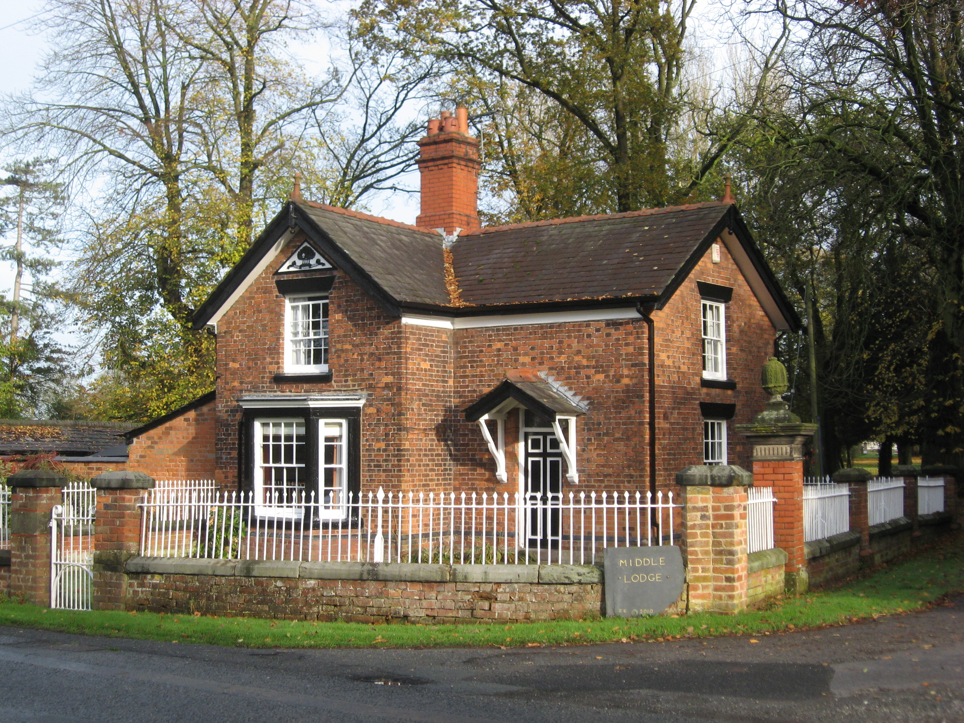
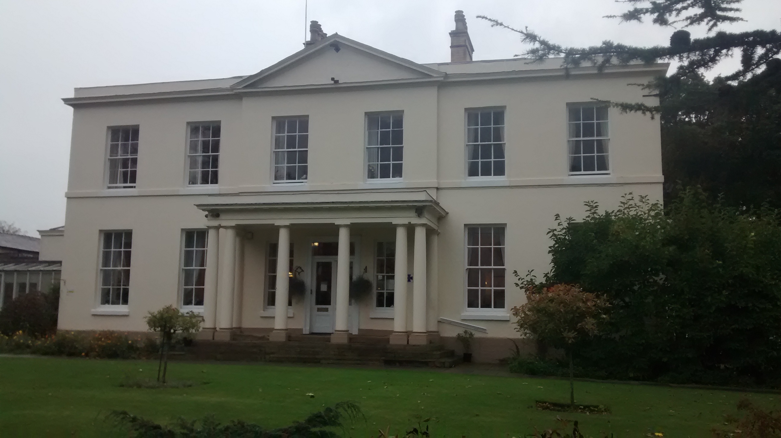
Bostock Hall

Bostock Hall is a country house to the northeast of Winsford, Cheshire, England. A former Georgian house, it was rebuilt in 1775 for Edward Tomkinson...

Moulton, Cheshire

Moulton is a civil parish and village in Cheshire, England, 3 miles (4.8 km) south of Northwich and 3 miles (4.8 km) north of Winsford. == History == The...

Moulton War Memorial

Moulton War Memorial stands in Main Road, Moulton, Cheshire, England. It consists of a marble statue of a soldier standing on a sandstone pedestal, and...

St Stephen's Church, Moulton

St Stephen's Church is in the village of Moulton, Cheshire, England. The church is recorded in the National Heritage List for England as a designated Grade...

Davenham Hall

Davenham Hall is a former country house to the southeast of the village of Davenham, Cheshire, England. It was built for Thomas Ravenscroft to replace...

Nearby Amenities

Located within 500m of 53.220611,-2.494215
Bus Stop
Bostock Green, London Road / Brick Kiln Lane
Bus: yes
Naptan AtcoCode: 0610VR024
Naptan Bearing: NW
Naptan CommonName: Brick Kiln Lane
Naptan Crossing: Brick Kiln Lane
Naptan Indicator: cnr
Naptan Landmark: 9 Bostock Road
Naptan LocalityName: Bostock Green
Naptan NaptanCode: chwgpaj
Naptan ShortCommonName: Brick Kiln Lane
Naptan Street: London Road
Naptan Verified: no
Public Transport: platform
Shelter: yes
Source: naptan_import
Lat/Long: 53.2192511/-2.4940918
Bus Stop
Bostock Green, London Road / Brick Kiln Lane
Bus: yes
Naptan AtcoCode: 0610VR072
Naptan Bearing: SE
Naptan BusStopType: CUS
Naptan CommonName: Brick Kiln Lane
Naptan Crossing: Brick Kiln Lane
Naptan Indicator: opp
Naptan Landmark: Bostock Black Smiths
Naptan LocalityName: Bostock Green
Naptan NaptanCode: chwgpjm
Naptan ShortCommonName: Brick Kiln Lane
Naptan Street: London Road
Naptan Verified: no
Public Transport: platform
Source: naptan_import
Lat/Long: 53.2194178/-2.4939531
Power: pole
Lat/Long: 53.2188416/-2.5010458
Power: pole
Lat/Long: 53.2196417/-2.5001774
Power: pole
Lat/Long: 53.2204769/-2.4997186
Power: pole
Lat/Long: 53.2212814/-2.4992963
Power: pole
Lat/Long: 53.2216633/-2.4978777
Power: pole
Lat/Long: 53.2220694/-2.496386
Power: pole
Lat/Long: 53.2228563/-2.4953056
Power: pole
Lat/Long: 53.2235557/-2.4945287
Power: pole
Lat/Long: 53.2176867/-2.4996018
Power: pole
Lat/Long: 53.2186717/-2.4999276
Power: pole
Lat/Long: 53.2204781/-2.5005395
Power: pole
Lat/Long: 53.2213503/-2.5008229
Power: pole
Lat/Long: 53.2222678/-2.5011403
Power: pole
Lat/Long: 53.2229307/-2.5002317
Power: pole
Lat/Long: 53.2235793/-2.4993391
Post Box
Collection Times: Mo-Fr 16:30; Sa 08:00
Ref: CW10 153
Lat/Long: 53.2193374/-2.4938831
Historic: monument
Inscription: This oak tree was planted by Revnd Canon Col and Cap E Hayhurstin the Jubilee Year of H M Queen Victoria 1887
Lat/Long: 53.2198982/-2.4944383
Defibrillator
Emergency: defibrillator
Lat/Long: 53.2191294/-2.4941359
Power: pole
Lat/Long: 53.2173632/-2.4894762
Power: pole
Lat/Long: 53.2175599/-2.4905558
Power: pole
Lat/Long: 53.2177566/-2.4916179
Power: pole
Lat/Long: 53.2179454/-2.4926949
Power: pole
Lat/Long: 53.2178249/-2.4929389
Power: pole
Lat/Long: 53.2176346/-2.4943672
Power: pole
Lat/Long: 53.2174419/-2.4958451
Power: pole
Lat/Long: 53.2173005/-2.4968737
Power: pole
Lat/Long: 53.2170853/-2.4985756
Man Made: tractor
Note: this is a disused tractor made available to the public
Lat/Long: 53.2193209/-2.4950431
The data included in this document is from www.openstreetmap.org. The data is made available under ODbL.

Have you been to Bostock Green?

Leave your review of Bostock Green below (or comments, questions and feedback).