Toberonochy

Settlement in Argyllshire

Scotland

Toberonochy

Luing - Kilchatton - Ruined church and associated graveyard This ruined church stands in its graveyard near to a road junction in the midst of the Isle of Luing just northwest of the village of Toberonochy.
The ruins of the church are a Designated Ancient Monument <span class="nowrap"><a title="http://portal.historicenvironment.scot/designation/SM3808" rel="nofollow ugc noopener" href="http://portal.historicenvironment.scot/designation/SM3808">Link</a><img style="margin-left:2px;" alt="External link" title="External link - shift click to open in new window" src="https://s1.geograph.org.uk/img/external.png" width="10" height="10"/></span> while the graveyard is Category 'B' listed <span class="nowrap"><a title="http://portal.historicenvironment.scot/designation/LB12196" rel="nofollow ugc noopener" href="http://portal.historicenvironment.scot/designation/LB12196">Link</a><img style="margin-left:2px;" alt="External link" title="External link - shift click to open in new window" src="https://s1.geograph.org.uk/img/external.png" width="10" height="10"/></span>
Canmore website information: <span class="nowrap"><a title="https://canmore.org.uk/site/22552/luing-kilchattan-old-parish-church" rel="nofollow ugc noopener" href="https://canmore.org.uk/site/22552/luing-kilchattan-old-parish-church">Link</a><img style="margin-left:2px;" alt="External link" title="External link - shift click to open in new window" src="https://s1.geograph.org.uk/img/external.png" width="10" height="10"/></span>
See also:
<a href="https://www.geograph.org.uk/photo/7258575">NM7409 : Luing - Kilchatton - Ruined church from its graveyard</a>
<a href="https://www.geograph.org.uk/photo/7258583">NM7409 : Luing - Kilchatton ruined church - grave slabs</a>
<a href="https://www.geograph.org.uk/photo/7258588">NM7409 : Luing - Kilchatton - Interior of ruined church</a>
<a href="https://www.geograph.org.uk/photo/7258592">NM7409 : Luing - Kilchatton - Graveyard to the west of ruined church</a>
Luing - Kilchatton - Ruined church and associated graveyard Credit: Rob Farrow

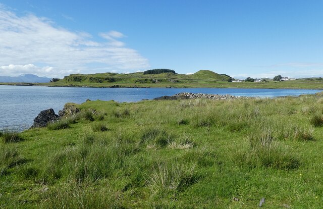
Toberonochy is a charming coastal village located in the historic county of Argyllshire, Scotland. Situated on the eastern shore of the Isle of Luing, it is surrounded by breathtaking natural beauty and offers a peaceful retreat for residents and visitors alike.

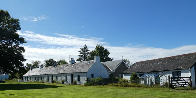
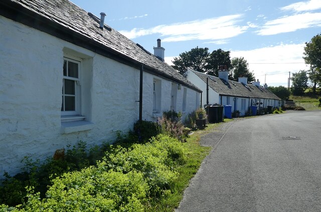
With a population of approximately 50 people, Toberonochy is a close-knit community that thrives on its strong sense of community spirit. The village is known for its picturesque white-washed cottages, traditional stone buildings, and stunning views across the Firth of Lorn.

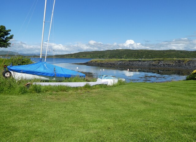
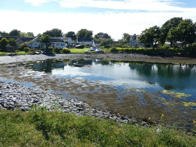
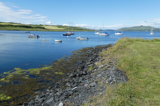
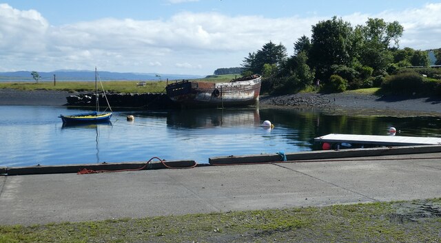
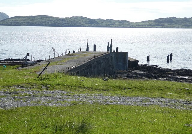
The village's main focal point is its small harbor, which provides a safe anchorage for local fishermen and boating enthusiasts. This picturesque harbor is often dotted with colorful fishing boats and yachts, giving it a postcard-perfect look.

Toberonochy is an ideal destination for those seeking tranquility and outdoor pursuits. The surrounding area offers opportunities for scenic walks along the coast, with magnificent views of the nearby islands and rugged cliffs. The village also benefits from being part of the Argyll Sea Kayak Trail, attracting kayakers who wish to explore the coastline.

Although Toberonochy is a small village, it is not lacking in amenities. There is a community hall that serves as a hub for various social activities and events, as well as a small shop where basic supplies can be purchased. Additionally, visitors can find accommodation options in nearby bed and breakfasts or self-catering cottages.

Toberonochy epitomizes the beauty and tranquility of the Scottish countryside, making it a hidden gem for those seeking a peaceful escape in Argyllshire.

If you have any feedback on the listing, please let us know in the comments section below.
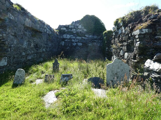
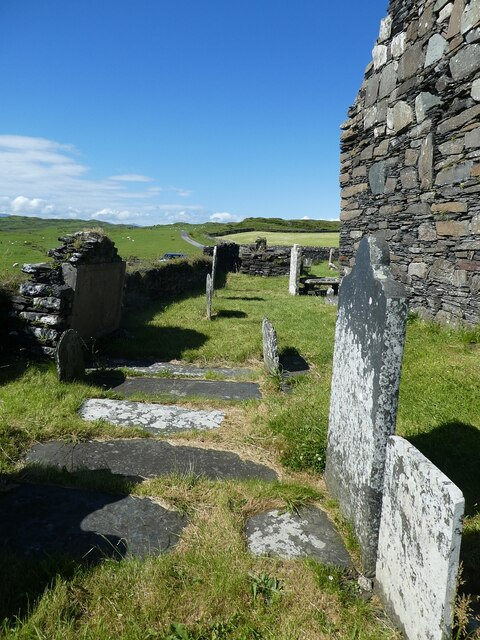
Toberonochy Images

Images are sourced within 2km of 56.217652/-5.6323911 or Grid Reference NM7408. Thanks to Geograph Open Source API. All images are credited.

Luing - Kilchatton - Ruined church and associated graveyard This ruined church stands in its graveyard near to a road junction in the midst of the Isle of Luing just northwest of the village of Toberonochy.
The ruins of the church are a Designated Ancient Monument <span class="nowrap"><a title="http://portal.historicenvironment.scot/designation/SM3808" rel="nofollow ugc noopener" href="http://portal.historicenvironment.scot/designation/SM3808">Link</a><img style="margin-left:2px;" alt="External link" title="External link - shift click to open in new window" src="https://s1.geograph.org.uk/img/external.png" width="10" height="10"/></span> while the graveyard is Category 'B' listed <span class="nowrap"><a title="http://portal.historicenvironment.scot/designation/LB12196" rel="nofollow ugc noopener" href="http://portal.historicenvironment.scot/designation/LB12196">Link</a><img style="margin-left:2px;" alt="External link" title="External link - shift click to open in new window" src="https://s1.geograph.org.uk/img/external.png" width="10" height="10"/></span>
Canmore website information: <span class="nowrap"><a title="https://canmore.org.uk/site/22552/luing-kilchattan-old-parish-church" rel="nofollow ugc noopener" href="https://canmore.org.uk/site/22552/luing-kilchattan-old-parish-church">Link</a><img style="margin-left:2px;" alt="External link" title="External link - shift click to open in new window" src="https://s1.geograph.org.uk/img/external.png" width="10" height="10"/></span>
See also:
<a href="https://www.geograph.org.uk/photo/7258575">NM7409 : Luing - Kilchatton - Ruined church from its graveyard</a>
<a href="https://www.geograph.org.uk/photo/7258583">NM7409 : Luing - Kilchatton ruined church - grave slabs</a>
<a href="https://www.geograph.org.uk/photo/7258588">NM7409 : Luing - Kilchatton - Interior of ruined church</a>
<a href="https://www.geograph.org.uk/photo/7258592">NM7409 : Luing - Kilchatton - Graveyard to the west of ruined church</a>
Luing - Kilchatton - Ruined church and associated graveyard
This ruined church stands in its graveyard near to a road junction in the midst of the Isle of Luing just northwest of the village of Toberonochy. The ruins of the church are a Designated Ancient Monument LinkExternal link while the graveyard is Category 'B' listed LinkExternal link Canmore website information: LinkExternal link See also: NM7409 : Luing - Kilchatton - Ruined church from its graveyard NM7409 : Luing - Kilchatton ruined church - grave slabs NM7409 : Luing - Kilchatton - Interior of ruined church NM7409 : Luing - Kilchatton - Graveyard to the west of ruined church
Luing - Boat in Black Mill Bay This striking little red boat moored in Black Mill Bay on the west coast of the Isle of Luing caught my attention with its almost perfect reflection in the water.
The hill in the background is Cnoc Mòr which rises to 184' (56m).
Luing - Boat in Black Mill Bay
This striking little red boat moored in Black Mill Bay on the west coast of the Isle of Luing caught my attention with its almost perfect reflection in the water. The hill in the background is Cnoc Mòr which rises to 184' (56m).
Luing - Kilchatton - Ruined church from its graveyard Looking at the ruined church at Kilchatton near Toberonochy from the north.
The ruins of the church are a Designated Ancient Monument <span class="nowrap"><a title="http://portal.historicenvironment.scot/designation/SM3808" rel="nofollow ugc noopener" href="http://portal.historicenvironment.scot/designation/SM3808">Link</a><img style="margin-left:2px;" alt="External link" title="External link - shift click to open in new window" src="https://s1.geograph.org.uk/img/external.png" width="10" height="10"/></span> while the graveyard is Category 'B' listed <span class="nowrap"><a title="http://portal.historicenvironment.scot/designation/LB12196" rel="nofollow ugc noopener" href="http://portal.historicenvironment.scot/designation/LB12196">Link</a><img style="margin-left:2px;" alt="External link" title="External link - shift click to open in new window" src="https://s1.geograph.org.uk/img/external.png" width="10" height="10"/></span>
Canmore website information: <span class="nowrap"><a title="https://canmore.org.uk/site/22552/luing-kilchattan-old-parish-church" rel="nofollow ugc noopener" href="https://canmore.org.uk/site/22552/luing-kilchattan-old-parish-church">Link</a><img style="margin-left:2px;" alt="External link" title="External link - shift click to open in new window" src="https://s1.geograph.org.uk/img/external.png" width="10" height="10"/></span>
See also:
<a href="https://www.geograph.org.uk/photo/7218376">NM7409 : Luing - Kilchatton - Ruined church and associated graveyard</a>
<a href="https://www.geograph.org.uk/photo/7258583">NM7409 : Luing - Kilchatton ruined church - grave slabs</a>
<a href="https://www.geograph.org.uk/photo/7258588">NM7409 : Luing - Kilchatton - Interior of ruined church</a>
<a href="https://www.geograph.org.uk/photo/7258592">NM7409 : Luing - Kilchatton - Graveyard to the west of ruined church</a>
Luing - Kilchatton - Ruined church from its graveyard
Looking at the ruined church at Kilchatton near Toberonochy from the north. The ruins of the church are a Designated Ancient Monument LinkExternal link while the graveyard is Category 'B' listed LinkExternal link Canmore website information: LinkExternal link See also: NM7409 : Luing - Kilchatton - Ruined church and associated graveyard NM7409 : Luing - Kilchatton ruined church - grave slabs NM7409 : Luing - Kilchatton - Interior of ruined church NM7409 : Luing - Kilchatton - Graveyard to the west of ruined church
Luing - Kilchatton - Interior of ruined church Looking from the open eastern end of the ruined church at Kilchatton near Toberonochy on the Isle of Luing. The gravestones must post-date the ruination of the church.
See also:
<a href="https://www.geograph.org.uk/photo/7218376">NM7409 : Luing - Kilchatton - Ruined church and associated graveyard</a>
<a href="https://www.geograph.org.uk/photo/7258575">NM7409 : Luing - Kilchatton - Ruined church from its graveyard</a>
<a href="https://www.geograph.org.uk/photo/7258583">NM7409 : Luing - Kilchatton ruined church - grave slabs</a>
<a href="https://www.geograph.org.uk/photo/7258592">NM7409 : Luing - Kilchatton - Graveyard to the west of ruined church</a>
Luing - Kilchatton - Interior of ruined church
Looking from the open eastern end of the ruined church at Kilchatton near Toberonochy on the Isle of Luing. The gravestones must post-date the ruination of the church. See also: NM7409 : Luing - Kilchatton - Ruined church and associated graveyard NM7409 : Luing - Kilchatton - Ruined church from its graveyard NM7409 : Luing - Kilchatton ruined church - grave slabs NM7409 : Luing - Kilchatton - Graveyard to the west of ruined church
Luing - Kilchatton - Graveyard to the west of ruined church Looking along the western end of the ruined church at Kilchatton near Toberonochy on the Isle of Luing, with numerous gravestones between the church and the graveyard wall.
See also:
<a href="https://www.geograph.org.uk/photo/7218376">NM7409 : Luing - Kilchatton - Ruined church and associated graveyard</a>
<a href="https://www.geograph.org.uk/photo/7258575">NM7409 : Luing - Kilchatton - Ruined church from its graveyard</a>
<a href="https://www.geograph.org.uk/photo/7258583">NM7409 : Luing - Kilchatton ruined church - grave slabs</a>
<a href="https://www.geograph.org.uk/photo/7258588">NM7409 : Luing - Kilchatton - Interior of ruined church</a>
Luing - Kilchatton - Graveyard to the west of ruined church
Looking along the western end of the ruined church at Kilchatton near Toberonochy on the Isle of Luing, with numerous gravestones between the church and the graveyard wall. See also: NM7409 : Luing - Kilchatton - Ruined church and associated graveyard NM7409 : Luing - Kilchatton - Ruined church from its graveyard NM7409 : Luing - Kilchatton ruined church - grave slabs NM7409 : Luing - Kilchatton - Interior of ruined church
Luing - Toberonochy - Cottages Most of the older cottages in Toberonochy are Category 'B' listed, including this row of rubble-built cottages.
See listing here: <span class="nowrap"><a title="http://portal.historicenvironment.scot/designation/LB12198" rel="nofollow ugc noopener" href="http://portal.historicenvironment.scot/designation/LB12198">Link</a><img style="margin-left:2px;" alt="External link" title="External link - shift click to open in new window" src="https://s1.geograph.org.uk/img/external.png" width="10" height="10"/></span>
Pretty-much the whole of Toberonochy is a conservation area - see <span class="nowrap"><a title="https://www.argyll-bute.gov.uk/sites/default/files/planning-and-environment/Toberonochy%20Conservation%20Area.pdf" rel="nofollow ugc noopener" href="https://www.argyll-bute.gov.uk/sites/default/files/planning-and-environment/Toberonochy%20Conservation%20Area.pdf">Link</a><img style="margin-left:2px;" alt="External link" title="External link - shift click to open in new window" src="https://s1.geograph.org.uk/img/external.png" width="10" height="10"/></span>
Luing - Toberonochy - Cottages
Most of the older cottages in Toberonochy are Category 'B' listed, including this row of rubble-built cottages. See listing here: LinkExternal link Pretty-much the whole of Toberonochy is a conservation area - see LinkExternal link
Luing - Toberonochy - Beached dinghies A couple of dinghies hauled up beside one of several inlets or quays on the coast by the village of Toberonochy, Luing's second largest settlement after Cullipool.
Luing - Toberonochy - Beached dinghies
A couple of dinghies hauled up beside one of several inlets or quays on the coast by the village of Toberonochy, Luing's second largest settlement after Cullipool.
Luing - Toberonochy - Northern harbour There is quite a large parking area with inlets on either side of it which form Toberonochy Harbour. Houses on the end of this northern inlet have a very pleasant outlook.
Cf. <a href="https://www.geograph.org.uk/photo/7259159">NM7508 : Luing - Toberonochy - Southern harbour</a>
Luing - Toberonochy - Northern harbour
There is quite a large parking area with inlets on either side of it which form Toberonochy Harbour. Houses on the end of this northern inlet have a very pleasant outlook. Cf. NM7508 : Luing - Toberonochy - Southern harbour
Luing - Looking up Shuna Sound from Toberonochy This is a view along the northern section of Shuna Sound from beside Toberonochy Harbour. The land on the left is part of the Isle of Luing, while that on the right is the very lightly populated Isle of Shuna. Although Shuna has just three permanent residents (or some references say one!), there are several holiday properties that can be hired there - see <span class="nowrap"><a title="http://www.islandofshuna.co.uk/Cottages.html" rel="nofollow ugc noopener" href="http://www.islandofshuna.co.uk/Cottages.html">Link</a><img style="margin-left:2px;" alt="External link" title="External link - shift click to open in new window" src="https://s1.geograph.org.uk/img/external.png" width="10" height="10"/></span>
Shuna has an area of 451ha (1,114 acres), taking its population as 3, it has a population density of just 0.7/km2 (1.8/sq mi). Its highest point is Druim na Dubh Ghlaic at 90m (295')
Luing - Looking up Shuna Sound from Toberonochy
This is a view along the northern section of Shuna Sound from beside Toberonochy Harbour. The land on the left is part of the Isle of Luing, while that on the right is the very lightly populated Isle of Shuna. Although Shuna has just three permanent residents (or some references say one!), there are several holiday properties that can be hired there - see LinkExternal link Shuna has an area of 451ha (1,114 acres), taking its population as 3, it has a population density of just 0.7/km2 (1.8/sq mi). Its highest point is Druim na Dubh Ghlaic at 90m (295')
Luing - Toberonochy - Southern harbour The hull of an old boat leans against the western bank of the southern harbour at Toberonochy. Cf. <a href="https://www.geograph.org.uk/photo/7259140">NM7408 : Luing - Toberonochy - Northern harbour</a>
Luing - Toberonochy - Southern harbour
The hull of an old boat leans against the western bank of the southern harbour at Toberonochy. Cf. NM7408 : Luing - Toberonochy - Northern harbour
Luing - Toberonochy - The road out of the village Looking along the street that leads out of the picturesque little village of Toberonochy on the Isle of Luing. Almost the entire village is HES Category 'B' listed - see <span class="nowrap"><a title="http://portal.historicenvironment.scot/designation/LB12198" rel="nofollow ugc noopener" href="http://portal.historicenvironment.scot/designation/LB12198">Link</a><img style="margin-left:2px;" alt="External link" title="External link - shift click to open in new window" src="https://s1.geograph.org.uk/img/external.png" width="10" height="10"/></span>
Luing - Toberonochy - The road out of the village
Looking along the street that leads out of the picturesque little village of Toberonochy on the Isle of Luing. Almost the entire village is HES Category 'B' listed - see LinkExternal link
Luing - Looking across Black Mill Bay to Ardlarach A view across the semicircular Black Mill Bay from the eponymous settlement of Blackmillbay to the land around Ardlarach with Cnoc Mòr rising behind it to the left (west).
Luing - Looking across Black Mill Bay to Ardlarach
A view across the semicircular Black Mill Bay from the eponymous settlement of Blackmillbay to the land around Ardlarach with Cnoc Mòr rising behind it to the left (west).
Luing - Blackmillbay - Jetty The concrete section of this jetty at Blackmillbay on Luing still stands but what looks as though was a wooden continuation of it looks to be long gone. The jetty juts out to the west into the Sound of Luing. The island seen in the distance is Lunga (Population: 0, Area: 250ha (1 mile²), Highest point: Bidean na h-Iolaire 98m (322'))
Luing - Blackmillbay - Jetty
The concrete section of this jetty at Blackmillbay on Luing still stands but what looks as though was a wooden continuation of it looks to be long gone. The jetty juts out to the west into the Sound of Luing. The island seen in the distance is Lunga (Population: 0, Area: 250ha (1 mile²), Highest point: Bidean na h-Iolaire 98m (322'))
Luing - Luing Cattle - a small herd A little group of the good-looking Luing Cattle a breed named after the island. The breed is three quarters Beef Shorthorn and one quarter Highland. They are a very hardy beef cow that can raise their calves in harsh conditions.
See Wikipedia article here: <span class="nowrap"><a title="https://en.wikipedia.org/wiki/Luing_cattle" rel="nofollow ugc noopener" href="https://en.wikipedia.org/wiki/Luing_cattle">Link</a><img style="margin-left:2px;" alt="External link" title="External link - shift click to open in new window" src="https://s1.geograph.org.uk/img/external.png" width="10" height="10"/></span>
Luing Cattle Society webpage here: <span class="nowrap"><a title="https://luingcattlesociety.co.uk" rel="nofollow ugc noopener" href="https://luingcattlesociety.co.uk">Link</a><img style="margin-left:2px;" alt="External link" title="External link - shift click to open in new window" src="https://s1.geograph.org.uk/img/external.png" width="10" height="10"/></span>
See also:
<a href="https://www.geograph.org.uk/photo/7259236">NM7409 : Luing - A small herd of Luing cattle on a ridge</a>
<a href="https://www.geograph.org.uk/photo/7259238">NM7409 : Luing - A Luing cow</a>
Luing - Luing Cattle - a small herd
A little group of the good-looking Luing Cattle a breed named after the island. The breed is three quarters Beef Shorthorn and one quarter Highland. They are a very hardy beef cow that can raise their calves in harsh conditions. See Wikipedia article here: LinkExternal link Luing Cattle Society webpage here: LinkExternal link See also: NM7409 : Luing - A small herd of Luing cattle on a ridge NM7409 : Luing - A Luing cow
Luing - A small herd of Luing cattle on a ridge This little group of the Luing Cattle were moving slowly across the ridge north of the lane from Blackmillbay to Toberonochy on the island from which they get their name.
The breed is three quarters Beef Shorthorn and one quarter Highland. They are a very hardy beef cow that can raise their calves in harsh conditions.
See Wikipedia article here: <span class="nowrap"><a title="https://en.wikipedia.org/wiki/Luing_cattle" rel="nofollow ugc noopener" href="https://en.wikipedia.org/wiki/Luing_cattle">Link</a><img style="margin-left:2px;" alt="External link" title="External link - shift click to open in new window" src="https://s1.geograph.org.uk/img/external.png" width="10" height="10"/></span>
Luing Cattle Society webpage here: <span class="nowrap"><a title="https://luingcattlesociety.co.uk" rel="nofollow ugc noopener" href="https://luingcattlesociety.co.uk">Link</a><img style="margin-left:2px;" alt="External link" title="External link - shift click to open in new window" src="https://s1.geograph.org.uk/img/external.png" width="10" height="10"/></span>
See also:
<a href="https://www.geograph.org.uk/photo/7259232">NM7409 : Luing - Luing Cattle - a small herd</a>
<a href="https://www.geograph.org.uk/photo/7259238">NM7409 : Luing - A Luing cow</a>
Luing - A small herd of Luing cattle on a ridge
This little group of the Luing Cattle were moving slowly across the ridge north of the lane from Blackmillbay to Toberonochy on the island from which they get their name. The breed is three quarters Beef Shorthorn and one quarter Highland. They are a very hardy beef cow that can raise their calves in harsh conditions. See Wikipedia article here: LinkExternal link Luing Cattle Society webpage here: LinkExternal link See also: NM7409 : Luing - Luing Cattle - a small herd NM7409 : Luing - A Luing cow
Luing - A Luing cow This fine beast was munching on the grassland of the Isle of Luing from which the breed gets its name.
The breed is three quarters Beef Shorthorn and one quarter Highland. They are a very hardy beef cow that can raise their calves in harsh conditions.
See Wikipedia article here: <span class="nowrap"><a title="https://en.wikipedia.org/wiki/Luing_cattle" rel="nofollow ugc noopener" href="https://en.wikipedia.org/wiki/Luing_cattle">Link</a><img style="margin-left:2px;" alt="External link" title="External link - shift click to open in new window" src="https://s1.geograph.org.uk/img/external.png" width="10" height="10"/></span>
Luing Cattle Society webpage here: <span class="nowrap"><a title="https://luingcattlesociety.co.uk" rel="nofollow ugc noopener" href="https://luingcattlesociety.co.uk">Link</a><img style="margin-left:2px;" alt="External link" title="External link - shift click to open in new window" src="https://s1.geograph.org.uk/img/external.png" width="10" height="10"/></span>
See also:
<a href="https://www.geograph.org.uk/photo/7259232">NM7409 : Luing - Luing Cattle - a small herd</a>
<a href="https://www.geograph.org.uk/photo/7259236">NM7409 : Luing - A small herd of Luing cattle on a ridge</a>
Luing - A Luing cow
This fine beast was munching on the grassland of the Isle of Luing from which the breed gets its name. The breed is three quarters Beef Shorthorn and one quarter Highland. They are a very hardy beef cow that can raise their calves in harsh conditions. See Wikipedia article here: LinkExternal link Luing Cattle Society webpage here: LinkExternal link See also: NM7409 : Luing - Luing Cattle - a small herd NM7409 : Luing - A small herd of Luing cattle on a ridge
Blackmill Bay, Luing
Show me another place!

Toberonochy is located at Grid Ref: NM7408 (Lat: 56.217652, Lng: -5.6323911)

Unitary Authority: Argyll and Bute

Police Authority: Argyll and West Dunbartonshire

What 3 Words

///feeds.inhaled.cluttered. Near Lochbuie, Argyll & Bute

Nearby Locations

Toberonochy

Related Wikis

Ardinamir

Ardinamir is an anchorage and small settlement on the island of Luing in Argyll and Bute, Scotland. == References ==

Shuna, Slate Islands

Shuna (Scottish Gaelic: Siuna) is one of the Slate Islands lying east of Luing on the west coast of Scotland. == History == In 1815, James Yates, a Glasgow...

Luing

Luing ( LING; Scottish Gaelic: Luinn) is one of the Slate Islands, Firth of Lorn, in the west of Argyll in Scotland, about 16 miles (26 km) south of Oban...

Slate Islands

The Slate Islands are an island group in the Inner Hebrides, lying immediately off the west coast of Scotland, north of Jura and southwest of Oban. The...

Lunga, Firth of Lorn

Lunga is one of the Slate Islands in the Firth of Lorn in Argyll and Bute, Scotland. The "Grey Dog" tidal race, which runs in the sea channel to the south...

Scarba, Lunga and the Garvellachs National Scenic Area

Scarba, Lunga and the Garvellachs is the name of one of the 40 national scenic areas of Scotland. The designated area covers the islands of Scarba, Lunga...

Torsa

Torsa (occasionally Torsay) is one of the Slate Islands in Argyll and Bute, Scotland. Lying east of Luing and south of Seil, this tidal island was inhabited...

Fladda, Slate Islands

Fladda is one of the Slate Islands, off the west coast of Argyll and Bute, Scotland. Fladda is an islet in the Sound of Luing, between Luing and Belnahua...

Nearby Amenities

Located within 500m of 56.217652,-5.6323911
Source: PGS
Lat/Long: 56.2215242/-5.6302063
Source: PGS
Lat/Long: 56.2207638/-5.6305474
Source: PGS
Lat/Long: 56.2206221/-5.630652
Source: PGS
Lat/Long: 56.2206063/-5.6317646
Source: PGS
Lat/Long: 56.2202192/-5.6323332
Source: PGS
Lat/Long: 56.2201451/-5.6322176
Source: PGS
Lat/Long: 56.2197624/-5.6329292
Source: PGS
Lat/Long: 56.2197496/-5.6331371
Source: PGS
Lat/Long: 56.2196938/-5.6334641
Source: PGS
Lat/Long: 56.2194327/-5.6341083
Source: PGS
Lat/Long: 56.2189691/-5.6343943
Created By: dmgroom_coastlines
Source: PGS
Lat/Long: 56.21863/-5.634052
Source: PGS
Lat/Long: 56.2182961/-5.633441
Source: PGS
Lat/Long: 56.2179385/-5.6323896
Source: PGS
Lat/Long: 56.2181056/-5.6318751
Source: PGS
Lat/Long: 56.2176791/-5.6309506
Source: PGS
Lat/Long: 56.2174415/-5.6309256
Source: PGS
Lat/Long: 56.2169751/-5.6305406
Source: PGS
Lat/Long: 56.2174801/-5.6298953
Source: PGS
Lat/Long: 56.2167568/-5.6296672
Source: PGS
Lat/Long: 56.2165983/-5.6302704
Source: PGS
Lat/Long: 56.2165486/-5.6303811
Source: PGS
Lat/Long: 56.216452/-5.6305967
Source: PGS
Lat/Long: 56.2161127/-5.6297118
Source: PGS
Lat/Long: 56.2155389/-5.6301011
Source: PGS
Lat/Long: 56.2153084/-5.6303028
Source: PGS
Lat/Long: 56.2148377/-5.6302594
Source: PGS
Lat/Long: 56.2143236/-5.6301962
Source: PGS
Lat/Long: 56.2136118/-5.6304755
Slate Quarry
Landuse: quarry
Status: abandoned
Lat/Long: 56.215887/-5.6320819
Toberonochy
Name En: Toberonochy
Name Gd: Tobar Dhonnchaidh
Place: village
Lat/Long: 56.2174826/-5.6312801
Power: pole
Lat/Long: 56.2188644/-5.6393273
Power: pole
Lat/Long: 56.2184889/-5.6380572
Power: pole
Lat/Long: 56.2189153/-5.6393164
Power: pole
Lat/Long: 56.2191236/-5.6396061
Power: pole
Lat/Long: 56.2181231/-5.636859
Power: pole
Lat/Long: 56.2178227/-5.6358134
Power: pole
Lat/Long: 56.2174738/-5.63465
Power: pole
Lat/Long: 56.2176252/-5.6335314
Power: pole
Lat/Long: 56.2176464/-5.6331283
Power: pole
Lat/Long: 56.217922/-5.6340204
Power: pole
Lat/Long: 56.2163672/-5.6308758
Power: pole
Lat/Long: 56.2165301/-5.6319389
Power: pole
Lat/Long: 56.2167421/-5.6331218
Power: pole
Lat/Long: 56.2171225/-5.6333418
Telephone
Booth: K6
Covered: booth
Man Made: telephone_box
Phone: +44 1852 4285
Lat/Long: 56.2177278/-5.6331114
Post Box
Collection Times: Mo-Fr 09:00; Sa 07:00
Operator: Royal Mail
Post Box Type: lamp
Ref: PA34 15D
Royal Cypher: scottish_crown
Lat/Long: 56.2177112/-5.6330993
The data included in this document is from www.openstreetmap.org. The data is made available under ODbL.

Have you been to Toberonochy?

Leave your review of Toberonochy below (or comments, questions and feedback).