Bosherston

Settlement in Pembrokeshire

Wales

Bosherston

Bullslaughter Bay Looking South towards Mewsford Point.
Bullslaughter Bay Credit: Paul Allison

Bosherston is a small village located in the Pembrokeshire Coast National Park in Wales, United Kingdom. Situated near the town of Pembroke, it is known for its picturesque natural beauty and historic landmarks.

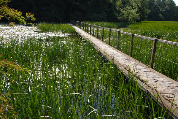
The village is nestled between the imposing limestone cliffs of the Stackpole Estate and the tranquil Bosherston Lakes, which are a series of man-made freshwater ponds. These lakes are teeming with diverse wildlife, including rare birds, otters, and dragonflies, making them a popular destination for nature enthusiasts and birdwatchers.

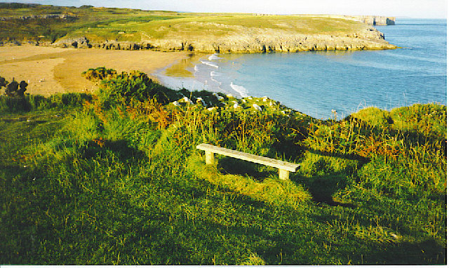
One of the main attractions in Bosherston is the stunning Broad Haven South Beach, which lies just a short distance from the village. This sandy beach is backed by towering cliffs and offers breathtaking views of the Atlantic Ocean. It is an ideal spot for swimming, sunbathing, and picnicking.

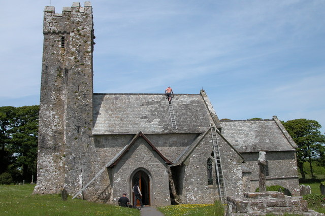
Bosherston is also home to the enchanting St. Govan's Chapel, a 13th-century hermit's cell built into the cliffs. Legend has it that St. Govan, a hermit who lived here, was saved from pirates by the cliffs opening up and sheltering him. The chapel is a popular pilgrimage site and a fascinating historical landmark.

Visitors to Bosherston can enjoy a variety of outdoor activities, such as hiking along the Pembrokeshire Coast Path, exploring the nearby Stackpole Estate with its walled gardens and ancient woodlands, or taking a boat trip to the nearby islands of Skomer and Skokholm to observe the abundant wildlife.

In summary, Bosherston is a charming village in Pembrokeshire that offers a combination of natural beauty, stunning coastline, and rich history, making it an ideal destination for outdoor enthusiasts and those seeking a peaceful retreat.

If you have any feedback on the listing, please let us know in the comments section below.

Bosherston Images

Images are sourced within 2km of 51.614196/-4.941205 or Grid Reference SR9694. Thanks to Geograph Open Source API. All images are credited.

Bullslaughter Bay Looking South towards Mewsford Point.
Bullslaughter Bay
Looking South towards Mewsford Point.
Bosherton Lily Ponds In June this three mile stretch of water is covered with white lilies.
Bosherton Lily Ponds
In June this three mile stretch of water is covered with white lilies.
Bosherston Lakes The lakes, or lily ponds, are part of the National Trust's Stackpole Estate.
Bosherston Lakes
The lakes, or lily ponds, are part of the National Trust's Stackpole Estate.
The bridge at Stackpole Centre The eight arch bridge heading back through Stackpole Park
The bridge at Stackpole Centre
The eight arch bridge heading back through Stackpole Park
Broad Haven, Pembrokeshire Rough seas at Broad Haven, the blocked entrance to Bosherston Lily Ponds
Broad Haven, Pembrokeshire
Rough seas at Broad Haven, the blocked entrance to Bosherston Lily Ponds
Huntsmans Leap Massive chasm cut into the limestone by the sea. It extends well into the square to the south, but the climbers are in SR9693. The routes out of here tend to be hard.
Huntsmans Leap
Massive chasm cut into the limestone by the sea. It extends well into the square to the south, but the climbers are in SR9693. The routes out of here tend to be hard.
Church at Bosherton The church is dedicated to St Michael and All Angels.
Church at Bosherton
The church is dedicated to St Michael and All Angels.
Broad Haven beach Looking NE from the car park walk down to the beach.
Broad Haven beach
Looking NE from the car park walk down to the beach.
Bridge by Lily Ponds On the way to the "Water Lilies" GeoCache. A beautiful walk in the woods.
Bridge by Lily Ponds
On the way to the "Water Lilies" GeoCache. A beautiful walk in the woods.
Lilies on the Bosherston Ponds. Dammed for Fishing Ponds.
Lilies on the Bosherston Ponds.
Dammed for Fishing Ponds.
The upper bridge at Bosherston Ponds.
Broad Haven. Evening on the Pembroke Coastal Path.
Broad Haven.
Evening on the Pembroke Coastal Path.
Sea Caves by Stackpole Warren. On the Pembrokeshire Coastal Path.
Sea Caves by Stackpole Warren.
On the Pembrokeshire Coastal Path.
Bridge 8 arch bridge on the Stackpole Estate.
Bridge
8 arch bridge on the Stackpole Estate.
Wall Clump A walled clump of trees named on the OS map as 'Wall Clump'.
Wall Clump
A walled clump of trees named on the OS map as 'Wall Clump'.
Eight arch bridge at Stackpole
St. Govan's Chapel
St. Govan's Chapel
Bosherston Lily Ponds
Show me another place!

Bosherston is located at Grid Ref: SR9694 (Lat: 51.614196, Lng: -4.941205)

Unitary Authority: Pembrokeshire

Police Authority: Dyfed Powys

Also known as: Llanfihangel-clogwyn-gofan

What 3 Words

///timeless.detective.composer. Near Bosherston, Pembrokeshire

Related Wikis

Bosherston

Bosherston (Welsh: Llanfihangel-clogwyn-gofan, translates to "St Michaels above the cliffs of St Gofan") is a village and parish in Pembrokeshire, Wales...

Bosherston Lakes

Bosherston Lakes or Bosherston Lily Ponds is a lake system with three principal arms. The lakes were created by damming a small river on the Stackpole...

Broad Haven South

Broad Haven South is a beach located 1 mile (1.6 km) southeast of Bosherston on the edge of the Stackpole Estate in Pembrokeshire, Wales. Broad Haven...
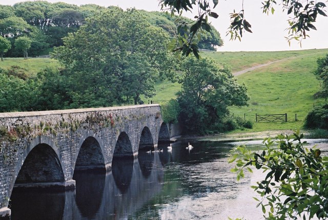
Eight-Arch Bridge

The Eight Arch Bridge on the Stackpole Estate is a grade II* listed construction, in Pembrokeshire, Wales. It is owned and maintained by the National...

Nearby Amenities

Located within 500m of 51.614196,-4.941205
Bosherston
Is In: Pembrokeshire, Wales, UK
Name Cy: Llanfihangel-clogwyn-gofan
Place: village
Wikidata: Q4947259
Wikipedia: en:Bosherston
Lat/Long: 51.6153072/-4.9395899
Waste Basket
Lat/Long: 51.6155066/-4.9366251
Bench
Backrest: no
Lat/Long: 51.6153275/-4.9365124
Give Way
Direction: backward
Lat/Long: 51.6131485/-4.9394811
Dragons Rest
Addr City: Pembroke
Addr Housename: Dragons Rrest
Addr Postcode: SA71 5DN
Addr Street: Bosherston
Guest House: bed_and_breakfast
Tourism: guest_house
Lat/Long: 51.6157126/-4.9430804
Direction: 150
Generator Method: photovoltaic
Generator Output Electricity: yes
Generator Solar Modules: 14
Generator Source: solar
Generator Type: solar_photovoltaic_panel
Location: roof
Power: generator
Lat/Long: 51.6135847/-4.9389821
Direction: 150
Generator Method: photovoltaic
Generator Output Electricity: yes
Generator Solar Modules: 16
Generator Source: solar
Generator Type: solar_photovoltaic_panel
Location: roof
Power: generator
Lat/Long: 51.6134648/-4.9392799
Direction: 150
Generator Method: photovoltaic
Generator Output Electricity: yes
Generator Solar Modules: 14
Generator Source: solar
Generator Type: solar_photovoltaic_panel
Location: roof
Power: generator
Lat/Long: 51.6132477/-4.9386874
Direction: SSW
Generator Method: photovoltaic
Generator Output Electricity: yes
Generator Solar Modules: 8
Generator Source: solar
Generator Type: solar_photovoltaic_panel
Location: roof
Power: generator
Lat/Long: 51.6126628/-4.9390693
Shelter
Shelter Type: public_transport
Lat/Long: 51.6132731/-4.9393237
Post Box
Post Box Type: lamp
Royal Cypher: EIIR
Royal Cypher Wikidata: Q33102113
Lat/Long: 51.6129467/-4.9396778
The data included in this document is from www.openstreetmap.org. The data is made available under ODbL.

Have you been to Bosherston?

Leave your review of Bosherston below (or comments, questions and feedback).