Borden

Settlement in Kent Swale

England

Borden

Woodgate Oast, Woodgate Lane, Oad Street Two round kiln oast house. Partially converted to accommodation in early 2000s. Has permission to convert to a ten bedroom hotel.
Woodgate Oast, Woodgate Lane, Oad Street Credit: Oast House Archive

Borden is a small village located in the county of Kent, England. Situated approximately 6 miles south-east of the town of Sittingbourne, Borden is nestled within a rural landscape characterized by rolling hills and picturesque countryside.

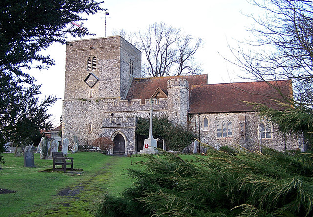
The village is home to a population of around 1,500 residents, creating a close-knit community atmosphere. Borden boasts a range of amenities, including a primary school, a church, a local pub, and a small selection of shops catering to everyday needs. The village is well-connected to surrounding areas, with good transport links to nearby towns and cities.

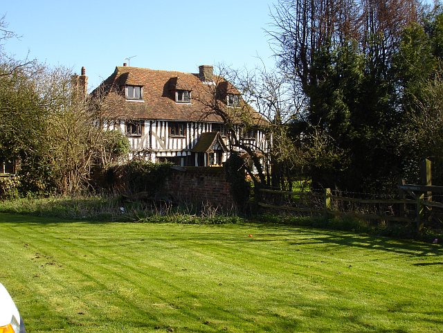
Borden is steeped in history, with evidence of its existence dating back to the Roman period. The village's name originates from the Old English word "bord," meaning a table or plank, referring to the flat, open landscape that once characterized the area. Today, Borden maintains its rural charm, with a mix of traditional and modern architecture dotted throughout the village.

The surrounding countryside offers opportunities for outdoor activities such as walking, cycling, and horse riding. Borden is also conveniently located near several notable attractions, including the historic Leeds Castle, which is just a short drive away.

Overall, Borden provides a peaceful and idyllic setting for residents and visitors alike, combining a sense of community with easy access to amenities and the natural beauty of the Kent countryside.

If you have any feedback on the listing, please let us know in the comments section below.

Borden Images

Images are sourced within 2km of 51.330289/0.704395 or Grid Reference TQ8862. Thanks to Geograph Open Source API. All images are credited.

Woodgate Oast, Woodgate Lane, Oad Street Two round kiln oast house. Partially converted to accommodation in early 2000s. Has permission to convert to a ten bedroom hotel.
Woodgate Oast, Woodgate Lane, Oad Street
Two round kiln oast house. Partially converted to accommodation in early 2000s. Has permission to convert to a ten bedroom hotel.
The Oast House, Wrens Road, Borden Single square kiln oast house. Black weatherboard stowage and slate roofs.
The Oast House, Wrens Road, Borden
Single square kiln oast house. Black weatherboard stowage and slate roofs.
The Oast House, Wrens Road, Borden Single square kiln oast house. Black weatherboard stowage and slate roofs.
The Oast House, Wrens Road, Borden
Single square kiln oast house. Black weatherboard stowage and slate roofs.
Wrens Road Looking towards The Oast House.
Wrens Road
Looking towards The Oast House.
The Oast, Hengist House, Borden Triple square kiln fake oast house. The building was built around 1990.
The Oast, Hengist House, Borden
Triple square kiln fake oast house. The building was built around 1990.
The Oast, Pond Farm Road, Borden Single square kiln oast house.
The Oast, Pond Farm Road, Borden
Single square kiln oast house.
The Oast, Pond Farm Road, Borden Single square kiln oast house.
The Oast, Pond Farm Road, Borden
Single square kiln oast house.
Field by Sutton Baron Road
243-247 Borden Lane Grade II listed <span class="nowrap"><a title="https://www.historicengland.org.uk/listing/the-list/list-entry/1069423" rel="nofollow ugc noopener" href="https://www.historicengland.org.uk/listing/the-list/list-entry/1069423">Link</a><img style="margin-left:2px;" alt="External link" title="External link - shift click to open in new window" src="https://s1.geograph.org.uk/img/external.png" width="10" height="10"/></span> Wealden hall house.
243-247 Borden Lane
Grade II listed LinkExternal link Wealden hall house.
College Road
College Road
Riddles Road
Riddles Road
Wises Oast, Wises Lane, Borden
Wises Oast, Wises Lane, Borden 20th century, internal kiln oast house, built 1950's. One cowl to roof. Converted to offices known as Wises Oast Business Centre.
Wises Oast, Wises Lane, Borden
20th century, internal kiln oast house, built 1950's. One cowl to roof. Converted to offices known as Wises Oast Business Centre.
Large barn at Vinson Farm
St Peter and St Paul Church, Borden The notable tower at Borden is Norman. The church was remodelled with aisles to the nave and chancel in the 13th century. The nave is short which reflects its Norman ancestry.
St Peter and St Paul Church, Borden
The notable tower at Borden is Norman. The church was remodelled with aisles to the nave and chancel in the 13th century. The nave is short which reflects its Norman ancestry.
Footpath near Borden Blossom brightens up this footpath just to the north of Borden.
Footpath near Borden
Blossom brightens up this footpath just to the north of Borden.
School Lane School Lane leads to Chestnut Street in the distance.
School Lane
School Lane leads to Chestnut Street in the distance.
Show me another place!

Borden is located at Grid Ref: TQ8862 (Lat: 51.330289, Lng: 0.704395)

Administrative County: Kent

District: Swale

Police Authority: Kent

What 3 Words

///headlines.cafe.confined. Near Sittingbourne, Kent

Related Wikis

Heart's Delight, Swale

Heart's Delight is a settlement located to the south of Sittingbourne in Kent, England. Heart's Delight Road, leading to it, has the postal address of...

Tunstall, Kent

Tunstall is a linear village and civil parish in Swale in Kent, England. It is about 2 km to the south-west of the centre of Sittingbourne, on a road towards...

Westlands School, Sittingbourne

Westlands School is a coeducational secondary school and sixth form with academy status, located in Sittingbourne in the English county of Kent.Previously...

Borden, Kent

Borden is a village and electoral ward situated immediately south west of Sittingbourne, Kent, from which it is separated by a small area of rural land...

Oad Street

Oad Street is a small hamlet in the English county of Kent.Oad Street forms part of the civil parish of Borden which, in turn, is part of Swale district...

Stiff Street

Stiff Street is a hamlet almost on the M2 motorway, near the village of Bredgar, in the Swale District, in the English county of Kent. The nearest town...

Chestnut Street, Kent

Chestnut Street is a settlement to the west of Sittingbourne in the Borough of Swale, Kent, England. It is located on the former A249 road alignment, between...

A249 road

The A249 is a road in Kent, England, running from Maidstone to Sheerness on the Isle of Sheppey. It mainly functions as a link between the M2 and M20 motorways...

Nearby Amenities

Located within 500m of 51.330289,0.704395
Curve Geometry: yes
Lat/Long: 51.3262408/0.7058463
Curve Geometry: yes
Lat/Long: 51.3265635/0.7054073
Curve Geometry: yes
Lat/Long: 51.3275059/0.7054474
Curve Geometry: yes
Lat/Long: 51.3316801/0.7077074
Curve Geometry: yes
Lat/Long: 51.3332663/0.7097154
Bus Stop
Harman's Corner
Bus: yes
Fixme: Can someone confirm whether or not busses stop here?
Flag: no
Naptan AtcoCode: 2400A010370A
Naptan Bearing: SW
Naptan BusStopType: CUS
Naptan CommonName: Harman's Corner
Naptan Indicator: adj
Naptan Landmark: Harman's Corner
Naptan NaptanCode: kntamgma
Naptan Street: Borden Lane
Naptan Verified: no
Public Transport: platform
Ref: kntamgma
Source: naptan_import
Source Date: 2008-03-26T11:08:00
Lat/Long: 51.3324396/0.7085323
Bus Stop
Harman's Corner
Bus: yes
Fixme: Can someone confirm whether or not busses stop here?
Flag: no
Naptan AtcoCode: 2400A010380A
Naptan Bearing: NE
Naptan BusStopType: CUS
Naptan CommonName: Harman's Corner
Naptan Indicator: opp
Naptan Landmark: Harman's Corner
Naptan NaptanCode: kntamgmd
Naptan Street: Borden Lane
Naptan Verified: no
Public Transport: platform
Ref: kntamgmd
Source: naptan_import
Source Date: 2018-08-20T14:42:00
Lat/Long: 51.3325164/0.7083215
Bus Stop
Mountview
Bus: yes
Fixme: Can someone confirm whether or not busses stop here?
Flag: no
Naptan AtcoCode: 2400A010390A
Naptan Bearing: NW
Naptan BusStopType: CUS
Naptan CommonName: Mountview
Naptan Indicator: opp
Naptan Landmark: Mountview
Naptan NaptanCode: kntamgmg
Naptan Street: The Street
Naptan Verified: no
Public Transport: platform
Ref: kntamgmg
Source: naptan_import
Source Date: 2018-08-20T14:44:00
Lat/Long: 51.3326314/0.7060742
Bus Stop
Mountview
Bus: yes
Naptan AtcoCode: 2400A010490A
Naptan Bearing: SE
Naptan CommonName: Mountview
Naptan Indicator: adj
Naptan Landmark: Mountview
Naptan NaptanCode: kntamgpt
Naptan Street: The Street
Naptan Verified: no
Public Transport: platform
Ref: kntamgpt
Source: naptan_import
Source Date: 2018-08-20T14:45:00
Lat/Long: 51.3327741/0.7061257
Turning Circle
Lat/Long: 51.3341079/0.7053439
Source: local_knowledge
Lat/Long: 51.3343422/0.7021821
Source: local_knowledge
Lat/Long: 51.3336851/0.707995
Source: local_knowledge
Lat/Long: 51.3346672/0.7051367
Source: local_knowledge
Lat/Long: 51.3342468/0.704526
Source: local_knowledge
Lat/Long: 51.3339198/0.7033464
Source: local_knowledge
Lat/Long: 51.334229/0.7059482
Curve Geometry: yes
Lat/Long: 51.3292375/0.7072258
Curve Geometry: yes
Lat/Long: 51.3306521/0.7085909
Curve Geometry: yes
Lat/Long: 51.3298339/0.7077262
Curve Geometry: yes
Lat/Long: 51.3314591/0.7077557
Curve Geometry: yes
Lat/Long: 51.330972/0.7084576
Wilbridge House
Building: yes
Lat/Long: 51.328824/0.7080911
Filmer House
Building: yes
Wikidata: Q26322344
Lat/Long: 51.3277878/0.7050735
Lenwood
Building: yes
Lat/Long: 51.3278518/0.7064191
Hearts Delight House
Building: yes
Wikidata: Q26627654
Lat/Long: 51.3267214/0.70579
Sharp's House
Building: yes
Wikidata: Q26627653
Lat/Long: 51.3283665/0.7068195
Curve Geometry: yes
Lat/Long: 51.3321963/0.7080604
Curve Geometry: yes
Lat/Long: 51.3323531/0.7082562
Curve Geometry: yes
Lat/Long: 51.3315221/0.7077146
Borden
Place: village
Lat/Long: 51.3339492/0.7024809
Post Box
Brand: Royal Mail
Brand Wikidata: Q638098
Brand Wikipedia: en:Royal Mail
Collection Times: Mo-Fr 16:15; Sa 09:45; Su off
Operator: Royal Mail
Operator Wikidata: Q638098
Post Box Mounting: pier
Post Box Type: lamp
Ref: ME10 47
Royal Cypher: EIIR
Royal Cypher Wikidata: Q33102113
Source: survey;streetlevel imagery;aerial imagery
Lat/Long: 51.3327433/0.7061446
Post Box
Addr Street: Tunstall Road
Brand: Royal Mail
Brand Wikidata: Q638098
Brand Wikipedia: en:Royal Mail
Collection Times: Mo-Fr 09:00; Sa 07:00; Su off
Drive Through: no
Operator: Royal Mail
Operator Wikidata: Q638098
Post Box Mounting: building
Post Box Type: lamp
Ref: ME10 64D
Royal Cypher: EIIR
Royal Cypher Wikidata: Q33102113
Source: survey;streetlevel imagery;aerial imagery
Lat/Long: 51.334159/0.7023469
Generator Method: photovoltaic
Generator Output Electricity: yes
Generator Source: solar
Generator Type: solar_photovoltaic_panel
Location: roof
Power: generator
Lat/Long: 51.3336215/0.703471
Generator Method: photovoltaic
Generator Output Electricity: yes
Generator Source: solar
Generator Type: solar_photovoltaic_panel
Location: roof
Power: generator
Lat/Long: 51.3260563/0.7058099
Generator Method: photovoltaic
Generator Output Electricity: yes
Generator Source: solar
Generator Type: solar_photovoltaic_panel
Location: roof
Power: generator
Lat/Long: 51.3260563/0.7049274
Generator Method: photovoltaic
Generator Output Electricity: yes
Generator Source: solar
Generator Type: solar_photovoltaic_panel
Location: roof
Power: generator
Lat/Long: 51.3299748/0.7075775
Generator Method: photovoltaic
Generator Output Electricity: yes
Generator Source: solar
Generator Type: solar_photovoltaic_panel
Location: roof
Power: generator
Lat/Long: 51.3325221/0.7072824
Generator Method: photovoltaic
Generator Output Electricity: yes
Generator Source: solar
Generator Type: solar_photovoltaic_panel
Location: roof
Power: generator
Lat/Long: 51.33152/0.7063436
Generator Method: photovoltaic
Generator Output Electricity: yes
Generator Source: solar
Generator Type: solar_photovoltaic_panel
Location: roof
Power: generator
Lat/Long: 51.3319306/0.7066226
The data included in this document is from www.openstreetmap.org. The data is made available under ODbL.

Have you been to Borden?

Leave your review of Borden below (or comments, questions and feedback).