The Mythe

Settlement in Gloucestershire Tewkesbury

England

The Mythe

Knights Way, Newton Knights Way in Newton, a late 1950s/earlier 1960s housing development beside the Ashchurch Road in Tewkesbury.
Knights Way, Newton Credit: Philip Halling

The Mythe is a small village located in the county of Gloucestershire, England. Situated on the banks of the River Severn, it is nestled within the beautiful countryside of the Cotswolds. The village is known for its picturesque landscapes, charming cottages, and rich history.

One of the key features of The Mythe is its close proximity to the River Severn. This has not only shaped the village's landscape but also played a significant role in its development over the years. The river has provided a source of livelihood for the residents, with fishing and boating being popular activities in the area.

The Mythe is also home to a number of historic landmarks. The most notable of these is The Mythe House, an elegant Georgian mansion that dates back to the 18th century. Surrounded by extensive gardens and parkland, it is a popular venue for weddings and events.

In addition to its natural and architectural beauty, The Mythe offers a range of recreational activities for residents and visitors alike. The village is surrounded by walking trails, providing ample opportunities for exploring the countryside and enjoying the fresh air. The nearby River Severn also offers opportunities for water sports such as kayaking and canoeing.

Despite its small size, The Mythe has a close-knit community and a strong sense of community spirit. The village is home to a local pub, where residents often gather for socializing and enjoying traditional English cuisine.

Overall, The Mythe is a quaint and idyllic village that offers a peaceful retreat for those seeking a break from the hustle and bustle of city life. With its natural beauty, historic landmarks, and friendly community, it is a place that truly captures the essence of rural England.

If you have any feedback on the listing, please let us know in the comments section below.

The Mythe Images

Images are sourced within 2km of 52.005279/-2.159489 or Grid Reference SO8934. Thanks to Geograph Open Source API. All images are credited.

Knights Way, Newton Knights Way in Newton, a late 1950s/earlier 1960s housing development beside the Ashchurch Road in Tewkesbury.
Knights Way, Newton
Knights Way in Newton, a late 1950s/earlier 1960s housing development beside the Ashchurch Road in Tewkesbury.
Ashchurch Road A438, a suburban main road east of Tewkesbury.
Ashchurch Road
A438, a suburban main road east of Tewkesbury.
A glimpse of Tewkesbury A glimpse of Tewkesbury from the footpath following the riverbank from the Fleet at Twyning.  There is a foot bridge between the trees.
A glimpse of Tewkesbury
A glimpse of Tewkesbury from the footpath following the riverbank from the Fleet at Twyning. There is a foot bridge between the trees.
Ram and ewes Ram and ewes in Cowham meadow beside the River Avon.  The ram is wearing a raddle which has its crayon colour changed so the farmer will know when the ewes are due to lamb.
Ram and ewes
Ram and ewes in Cowham meadow beside the River Avon. The ram is wearing a raddle which has its crayon colour changed so the farmer will know when the ewes are due to lamb.
Lodge, Ashchurch Road, Tewkesbury Formerly serving Walton House (<a href="https://www.geograph.org.uk/photo/7479718">SO9032 : Walton House, Churchill Grove, Tewkesbury</a>) and probably dating from c1880 when a lot of work was going on at the house.
Lodge, Ashchurch Road, Tewkesbury
Formerly serving Walton House (SO9032 : Walton House, Churchill Grove, Tewkesbury) and probably dating from c1880 when a lot of work was going on at the house.
Sheep in Cowham Meadow Sheep have been turned into Cowham Meadow before all of the grass has been cut for hay.  Normally the grass has been cut for hay in late May or early July, but this year the summer has been unsettled which has delayed the harvest.
Sheep in Cowham Meadow
Sheep have been turned into Cowham Meadow before all of the grass has been cut for hay. Normally the grass has been cut for hay in late May or early July, but this year the summer has been unsettled which has delayed the harvest.
Two Old Boundary Markers beside the A438 Ashchurch Road in Tewkesbury Two Parish Boundary Markers standing against the parapet of an old bridge over Tirle Brook on the south side of the A438 Ashchurch Road. Until a boundary change in 1935 this was the boundary of Tewkesbury and Ashchurch parishes. Now entirely in Tewkesbury. 

On the left is Milestone Society National ID: GL_TEWKES07pb which has no inscription.

On the right is Milestone Society National ID: GL_TEWKES06pb inscribed Tewk.
Two Old Boundary Markers beside the A438 Ashchurch Road in Tewkesbury
Two Parish Boundary Markers standing against the parapet of an old bridge over Tirle Brook on the south side of the A438 Ashchurch Road. Until a boundary change in 1935 this was the boundary of Tewkesbury and Ashchurch parishes. Now entirely in Tewkesbury. On the left is Milestone Society National ID: GL_TEWKES07pb which has no inscription. On the right is Milestone Society National ID: GL_TEWKES06pb inscribed Tewk.
Long straight at Mitton Lodge The road has just passed into Worcestershire.
Long straight at Mitton Lodge
The road has just passed into Worcestershire.
Tractor trying to access the B4080 Road scene near Bredon's Hardwick as 2011's harvest is brought in.
Tractor trying to access the B4080
Road scene near Bredon's Hardwick as 2011's harvest is brought in.
Restored Quarry The unlovely aspect of the water park at Bredon's Hardwick, not enhanced by scruffy signs or the displeasing sight of a caravan park.
Restored Quarry
The unlovely aspect of the water park at Bredon's Hardwick, not enhanced by scruffy signs or the displeasing sight of a caravan park.
Morrisons Supermarket, Tewkesbury
A438, Ashchurch Road Ashchurch Road, just to the east of Tewkesbury town centre.
A438, Ashchurch Road
Ashchurch Road, just to the east of Tewkesbury town centre.
View over the Avon valley In square is a flooded gravel pit, part of the Croft Farm Leisure and Water Park.
The Malvern Hills on the skyline.
View over the Avon valley
In square is a flooded gravel pit, part of the Croft Farm Leisure and Water Park. The Malvern Hills on the skyline.
Old railway line from Tewkesbury's first station Now a footpath, this was the course of the railway from Ashchurch to Tewkesbury's first railway station on a cramped site between Oldbury Road and High Street. 
It was replaced in 1864 by a later station, with the two lines joining in the middle distance of this image.
Old railway line from Tewkesbury's first station
Now a footpath, this was the course of the railway from Ashchurch to Tewkesbury's first railway station on a cramped site between Oldbury Road and High Street. It was replaced in 1864 by a later station, with the two lines joining in the middle distance of this image.
Housing developments on Bredon Road In recent years the land between Bredon Road and the River Avon has been built on, here the houses are viewed from the Mitton side of the Bredon Road.
Housing developments on Bredon Road
In recent years the land between Bredon Road and the River Avon has been built on, here the houses are viewed from the Mitton side of the Bredon Road.
Trafalgar Road, Tewkesbury Trafalgar Road is part of a recent housing development off Bredon Road, Tewkesbury.
Trafalgar Road, Tewkesbury
Trafalgar Road is part of a recent housing development off Bredon Road, Tewkesbury.
Digby Drive, Tewkesbury Looking NE from the corner of Mitton Way.
Digby Drive, Tewkesbury
Looking NE from the corner of Mitton Way.
Mitton Farm Shop and Dores Mitton News, Tewkesbury Two of several shops in a row alongside Mitton Way, Tewkesbury.
Mitton Farm Shop and Dores Mitton News, Tewkesbury
Two of several shops in a row alongside Mitton Way, Tewkesbury.
Show me another place!

The Mythe is located at Grid Ref: SO8934 (Lat: 52.005279, Lng: -2.159489)

Administrative County: Gloucestershire

District: Tewkesbury

Police Authority: Gloucestershire

What 3 Words

///essential.remedy.reset. Near Tewkesbury, Gloucestershire

Nearby Locations

The Mythe Mythe, The

Related Wikis

The Mythe

The Mythe is a house built on the top of a hill overlooking the town of Tewkesbury, England. There has been a house on the site for nearly a thousand years...
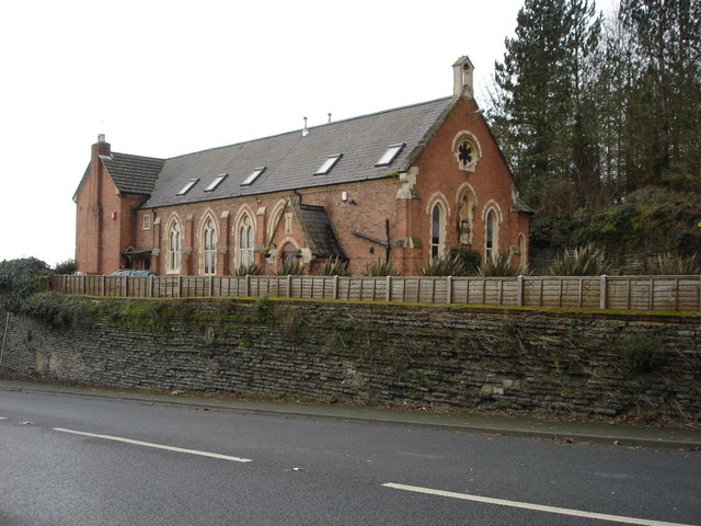
Mythe Chapel

The Mythe Chapel is located at Tewkesbury on the Mythe (off the A38 overlooking Mythe Bridge, between Severn Trent Water and the Tewkesbury Garden Centre...

Mythe Railway Nature Reserve

Mythe Railway Nature Reserve (grid reference SO887341) is a 2.8-hectare (6.9-acre) nature reserve in Gloucestershire. The site is listed in the ‘Tewkesbury...
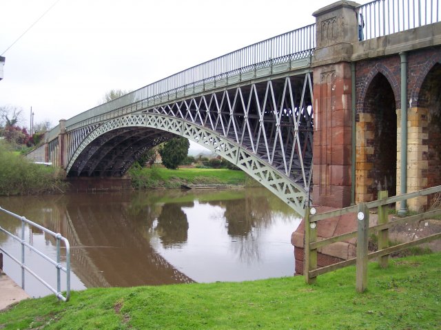
Mythe Bridge

Mythe Bridge carries the A438 road across the River Severn at Tewkesbury. It is a cast-iron arch bridge spanning 170 feet (52 m) and 24 feet (7.3 m) wide...

Nearby Amenities

Located within 500m of 52.005279,-2.159489
Source: Landsat photo
Lat/Long: 52.0049312/-2.165734
Source: Landsat photo
Lat/Long: 52.0041915/-2.164704
Source: Landsat photo
Lat/Long: 52.0033962/-2.1640722
Source: Landsat photo
Lat/Long: 52.0016282/-2.1634373
Source: Landsat photo
Lat/Long: 52.0022135/-2.1636038
Traffic Signals
Lat/Long: 52.0020164/-2.1625423
Mythe
Created By: Potlatch 0.10f
Is In: Tewkesbury
Place: suburb
Lat/Long: 52.0025262/-2.1589879
Bus Stop
Mythe Bridge Turn
Bus: yes
Naptan AtcoCode: 1600GLT005
Naptan Bearing: NW
Naptan CommonName: Mythe Bridge Turn
Naptan NaptanCode: glodmdgt
Naptan Street: Mythe Road
Naptan Verified: no
Public Transport: platform
Source: naptan_import
Lat/Long: 52.0015373/-2.1609072
Bus Stop
Mythe Bridge Turn
Bus: yes
Naptan AtcoCode: 1600GLT006
Naptan Bearing: SE
Naptan CommonName: Mythe Bridge Turn
Naptan Indicator: Opp
Naptan NaptanCode: glodmdja
Naptan Street: Mythe Road
Naptan Verified: no
Public Transport: platform
Source: naptan_import
Lat/Long: 52.0015645/-2.1607325
Bus Stop
Water Tower
Bus: yes
Naptan AtcoCode: 1600GLT071
Naptan Bearing: N
Naptan CommonName: Water Tower
Naptan NaptanCode: glodmawt
Naptan Street: Mythe Road
Naptan Verified: no
Public Transport: platform
Source: naptan_import
Lat/Long: 52.0079465/-2.1618626
Bus Stop
Water Tower
Bus: yes
Naptan AtcoCode: 1600GLT072
Naptan Bearing: S
Naptan CommonName: Water Tower
Naptan Indicator: Opp
Naptan NaptanCode: glodmdaj
Naptan Street: Mythe Road
Naptan Verified: no
Public Transport: platform
Source: naptan_import
Lat/Long: 52.0079108/-2.1616877
Historic: yes
Man Made: water_tower
Lat/Long: 52.0080624/-2.1619698
Tewkesbury Garden Centre
Addr Postcode: GL20 6EB
Addr Street: Worcester Road
Fhrs Id: 107549
Shop: garden_centre
Url: http://www.tewkesburygardencentre.com/
Lat/Long: 52.0053016/-2.1625364
Post Box
Collection Times: Mo-Fr 17:00; Sa 10:00
Operator: Royal Mail
Post Box Mounting: brick_pillar
Post Box Type: wall
Ref: GL20 42
Royal Cypher: EIIR
Royal Cypher Wikidata: Q33102113
Lat/Long: 52.0069889/-2.1617274
Marker: aerial
Operator: CLH
Operator Old: GPSS
Ref: MP 4128
Ref GPSS: 19416
Utility: oil
Lat/Long: 52.0022856/-2.1581704
Marker: pedestal
Operator: CLH
Operator Old: GPSS
Ref: MP 2491
Utility: oil
Lat/Long: 52.0055792/-2.1618739
Marker: aerial
Operator: CLH
Operator Old: GPSS
Ref GPSS: 19417
Utility: oil
Lat/Long: 52.0057095/-2.1620204
Marker: pedestal
Operator: CLH
Operator Old: GPSS
Ref: CP 2276
Utility: oil
Lat/Long: 52.0057163/-2.1620236
Marker: aerial
Operator: CLH
Operator Old: GPSS
Utility: oil
Lat/Long: 52.008424/-2.1641141
Marker: aerial
Operator: CLH
Operator Old: GPSS
Ref GPSS: 19509
Utility: oil
Lat/Long: 52.0068175/-2.1630431
Mythe North
Power: pole
Transformer: distribution
Voltage Primary: 11000
Lat/Long: 52.0081789/-2.1607178
Power: pole
Lat/Long: 52.0077489/-2.1600476
Power: pole
Lat/Long: 52.0073683/-2.1594666
Power: pole
Lat/Long: 52.006655/-2.159299
Power: pole
Lat/Long: 52.0059706/-2.1591152
Power: pole
Lat/Long: 52.0053407/-2.1589395
Mythe Church
Location Transition: yes
Power: pole
Transformer: distribution
Voltage Primary: 11000
Lat/Long: 52.0042939/-2.1616727
Power: pole
Lat/Long: 52.0046836/-2.1587518
The Mythe
Power: pole
Transformer: distribution
Voltage Primary: 11000
Lat/Long: 52.0040999/-2.1585815
Power: pole
Lat/Long: 52.0033948/-2.1575528
Power: pole
Lat/Long: 52.0029069/-2.1568085
Power: pole
Lat/Long: 52.0022447/-2.1558295
Power: pole
Lat/Long: 52.0017345/-2.1550664
The data included in this document is from www.openstreetmap.org. The data is made available under ODbL.

Have you been to The Mythe?

Leave your review of The Mythe below (or comments, questions and feedback).