An Sruthan

Settlement in Inverness-shire

Scotland

An Sruthan

A863 near Coillore
A863 near Coillore Credit: Steven Brown

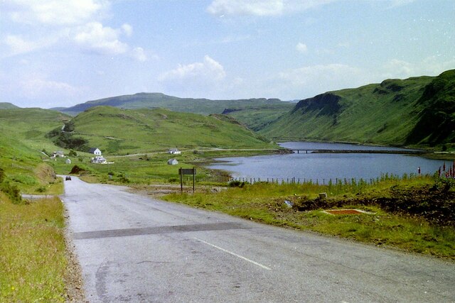
An Sruthan is a small village located in the region of Inverness-shire, Scotland. Situated on the banks of the River Beauly, it is surrounded by picturesque landscapes and offers a serene and tranquil environment for residents and visitors alike.

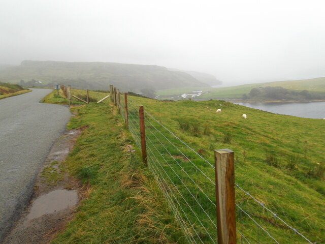
The village is known for its charming rural character, with traditional Scottish houses and stunning views of the nearby mountains and forests. The River Beauly, which runs through the village, is a popular spot for fishing enthusiasts, attracting anglers from all over the country. The river is also a great place for leisurely walks and picnics by the water's edge.

An Sruthan is well-connected to the nearby towns and cities, with Inverness, the capital of the Highlands, just a short drive away. This makes it an ideal location for those seeking a peaceful retreat while still having access to urban amenities.

The village has a strong sense of community, with a friendly and welcoming atmosphere. It boasts a local pub, where residents and visitors can socialize and enjoy traditional Scottish hospitality. There are also a few small shops and amenities within the village, ensuring that daily necessities are easily accessible.

For outdoor enthusiasts, An Sruthan offers numerous opportunities for hiking, cycling, and exploring the beautiful Scottish countryside. The surrounding area is home to several nature reserves and wildlife sanctuaries, making it a haven for nature lovers.

In summary, An Sruthan is a delightful village in Inverness-shire, Scotland, offering a peaceful and scenic setting. With its close proximity to Inverness and its abundance of outdoor activities, it is a destination that appeals to both residents and tourists seeking a taste of rural Scottish charm.

If you have any feedback on the listing, please let us know in the comments section below.

An Sruthan Images

Images are sourced within 2km of 57.356096/-6.420078 or Grid Reference NG3438. Thanks to Geograph Open Source API. All images are credited.

A863 near Coillore
A863 near Coillore
Road junction near Bracadale
Bracadale, Skye, 1988
Dun Beag Broch
Dun Beag Broch
Looking south over Gesto Bay
Mud exposures at Loch Beag Loch Beag is a minor sea loch which is effectively an arm north of the complex island and sea area at the meeting of Lochs Harport and Bracadale. The view is from a bridge carrying the A863 at the loch's north end.
Mud exposures at Loch Beag
Loch Beag is a minor sea loch which is effectively an arm north of the complex island and sea area at the meeting of Lochs Harport and Bracadale. The view is from a bridge carrying the A863 at the loch's north end.
Struan Jetty, Skye Small fishing jetty, viewed from the eastern shore of Loch Beag.
Struan Jetty, Skye
Small fishing jetty, viewed from the eastern shore of Loch Beag.
Dun Beag broch Looking across Loch Bracadale from the remains of the Dun Beag broch
Dun Beag broch
Looking across Loch Bracadale from the remains of the Dun Beag broch
Ullinish , Skye Looking north toward Ullinish Lodge Hotel
Ullinish , Skye
Looking north toward Ullinish Lodge Hotel
Ullinish Lodge Hotel, Isle of Skye
Dunbeg (or Dun Beag) Broch, Isle of Skye
Graves of Collie and MacKenzie at Struan churchyard Should be visited by all lovers of the Cuillin.
Graves of Collie and MacKenzie at Struan churchyard
Should be visited by all lovers of the Cuillin.
Gesto Bay, Loch Harport and the Cuillin Hills
Towards Macleod's Tables, Skye,  from the A863 Macleod's Tables of Healabhal Mhor (<a href="https://www.geograph.org.uk/gridref/NG2244">NG2244</a>) and Healabhal Bheag (<a href="https://www.geograph.org.uk/gridref/NG2242">NG2242</a>) as seen from the A863
Towards Macleod's Tables, Skye, from the A863
Macleod's Tables of Healabhal Mhor (NG2244) and Healabhal Bheag (NG2242) as seen from the A863
Dun Struan Beag
Dun Struan Beag
Former manse - Balgown The former manse of Balgown Parish Church <a href="https://www.geograph.org.uk/photo/1191836">NG3538 : Bracadale church</a>. The manse dates from c1790.
Former manse - Balgown
The former manse of Balgown Parish Church NG3538 : Bracadale church. The manse dates from c1790.
Dun Garsin A basalt knoll forming a good defensive site for a fort above Glen Bracadale.
Dun Garsin
A basalt knoll forming a good defensive site for a fort above Glen Bracadale.
Sheep Loading Ramp Near Ullinish. A steep drop onto the lorry!
Sheep Loading Ramp
Near Ullinish. A steep drop onto the lorry!
Show me another place!

An Sruthan is located at Grid Ref: NG3438 (Lat: 57.356096, Lng: -6.420078)

Unitary Authority: Highland

Police Authority: Highlands and Islands

Also known as: Struan

What 3 Words

///rots.tentacles.adopting. Near Carbost, Highland

Related Wikis

Dun Beag

Dun Beag is an iron-age broch located about 1 kilometre northwest of the village of Struan on the west coast of the island of Skye, in Scotland. ��2�...

Bracadale

Bracadale (Scottish Gaelic: Bracadal) is a settlement and parish on the Isle of Skye in Scotland. It lies on the west coast of the island, west-south-west...

Struan, Skye

Struan (Scottish Gaelic: An Sruthan) is a small village on the west coast of the island of Skye, on the shores of Loch Beag, itself an inlet of Loch Bracadale...

Ullinish

Ullinish (Gaelic: Uilfhinis) is a crofting township on Loch Bracadale, on the southwest coast of Skye, Scotland. The only promontory fort on Skye is located...

Nearby Amenities

Located within 500m of 57.356096,-6.420078
Struan
Name En: Struan
Name Gd: An Sruthan
Place: village
Wikidata: Q975495
Wikipedia: en:Struan, Skye
Lat/Long: 57.3566389/-6.4161359
Bus Stop
Post Office
Naptan AtcoCode: 670030023
Naptan Bearing: NW
Naptan CommonName: Post Office
Naptan Indicator: o/s
Naptan Landmark: Post Office
Naptan NaptanCode: 45326435
Naptan Street: A863
Naptan Verified: no
Source: naptan_import
Lat/Long: 57.3564055/-6.4209723
Bus Stop
Struan
Bus: yes
Departures Board: no
Naptan AtcoCode: 670030024
Naptan Bearing: E
Naptan CommonName: Church
Naptan Indicator: o/s
Naptan Landmark: Bus Shelter
Naptan NaptanCode: 45326437
Naptan Street: A863
Naptan Verified: no
Operator: None
Public Transport: platform
Shelter: yes
Source: naptan_import
Lat/Long: 57.3561082/-6.4174085
Bus Stop
Struan
Bus: yes
Departures Board: no
Naptan AtcoCode: 670030024A
Naptan Bearing: W
Naptan CommonName: Church
Naptan Indicator: opp
Naptan Landmark: Struan Church
Naptan NaptanCode: 45326438
Naptan Street: A863
Naptan Verified: no
Operator: None
Public Transport: platform
Shelter: no
Source: naptan_import
Lat/Long: 57.3560258/-6.4174024
Bus Stop
Post Office
Naptan AtcoCode: 6700713160A
Naptan Bearing: SE
Naptan CommonName: Post Office
Naptan Indicator: opp
Naptan Landmark: Post Office
Naptan NaptanCode: 45326436
Naptan Street: A863
Naptan Verified: no
Source: naptan_import
Lat/Long: 57.3565821/-6.4208105
Post Box
Ref: IV56 85
Source: survey
Lat/Long: 57.3562394/-6.4177108
Struanmore
Name En: Struanmor
Name Gd: Struthan Mòr
Place: hamlet
Source: survey
Lat/Long: 57.3546761/-6.4225368
Barrier: cattle_grid
Source: survey
Lat/Long: 57.3558683/-6.4197996
Entrance: main
Lat/Long: 57.3569216/-6.4217894
Entrance: main
Lat/Long: 57.3569856/-6.4215167
Power: pole
Lat/Long: 57.3589066/-6.4136222
Power: pole
Lat/Long: 57.3582378/-6.4139382
Power: pole
Lat/Long: 57.3577916/-6.4141556
Power: pole
Lat/Long: 57.357456/-6.4143147
Power: pole
Lat/Long: 57.3573931/-6.4158324
Power: pole
Lat/Long: 57.357354/-6.4168731
Power: pole
Lat/Long: 57.3572997/-6.4181091
Power: pole
Lat/Long: 57.3572747/-6.4189103
Power: pole
Lat/Long: 57.3572367/-6.4197175
Power: pole
Lat/Long: 57.3574343/-6.4204341
Power: pole
Lat/Long: 57.3577242/-6.4214647
Power: pole
Lat/Long: 57.3580521/-6.4226464
Power: pole
Lat/Long: 57.3583768/-6.423832
Power: pole
Lat/Long: 57.358759/-6.4253578
Power: pole
Lat/Long: 57.3570749/-6.4182128
Power: pole
Lat/Long: 57.3568762/-6.4183154
Power: pole
Lat/Long: 57.3570098/-6.4209162
Power: pole
Lat/Long: 57.354015/-6.4242014
Power: pole
Lat/Long: 57.354571/-6.4228929
Power: pole
Lat/Long: 57.3548837/-6.4222025
Power: pole
Lat/Long: 57.3551943/-6.4215805
Power: pole
Lat/Long: 57.3554505/-6.421045
Power: pole
Lat/Long: 57.3557166/-6.4204935
Power: pole
Lat/Long: 57.3560619/-6.4193461
Power: pole
Lat/Long: 57.3550694/-6.4254112
Power: pole
Lat/Long: 57.3547751/-6.4247851
Power: pole
Lat/Long: 57.3544787/-6.424141
Power: pole
Lat/Long: 57.3541459/-6.4234596
Power: pole
Lat/Long: 57.3568176/-6.4164112
The data included in this document is from www.openstreetmap.org. The data is made available under ODbL.

Have you been to An Sruthan?

Leave your review of An Sruthan below (or comments, questions and feedback).