Stockport Great Moor

Settlement in Cheshire

England

Stockport Great Moor

Cale Green Park toilets Toilet block in Cale Green Park.
Cale Green Park toilets Credit: Gerald England

Stockport Great Moor is a suburban area located in the county of Cheshire, in the North West of England. It is part of the larger town of Stockport and is situated approximately 7 miles southeast of Manchester city center. Great Moor is a predominantly residential area, offering a peaceful and family-friendly environment.

The area is known for its well-maintained streets, lined with rows of attractive Victorian and Edwardian houses. The architecture reflects the charm and character of the area, with many properties boasting original features. Great Moor is popular among families and professionals who appreciate the quiet and green surroundings, while still being within easy reach of urban amenities.

Great Moor benefits from excellent transport links, making it a convenient place to live. The area is served by several bus routes, providing connections to Stockport town center and surrounding areas. Additionally, Stockport train station is nearby, offering frequent services to Manchester and other major cities.

Residents of Great Moor enjoy a range of amenities in the vicinity. There are several local shops, supermarkets, and convenience stores, providing easy access to daily necessities. The area also benefits from a selection of schools, including primary and secondary options, ensuring good educational facilities for families.

For recreational activities, Great Moor Park is a popular spot among locals, offering green spaces for walking, jogging, and picnicking. The park also hosts community events and has a children's play area. Overall, Great Moor offers a pleasant and convenient living environment, combining the tranquility of suburban life with easy access to nearby urban centers.

If you have any feedback on the listing, please let us know in the comments section below.

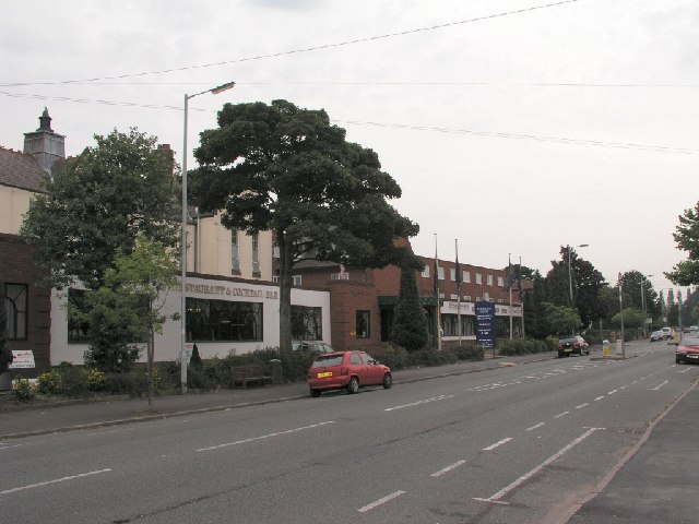
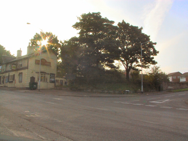
Stockport Great Moor Images

Images are sourced within 2km of 53.392979/-2.133802 or Grid Reference SJ9188. Thanks to Geograph Open Source API. All images are credited.

Cale Green Park toilets Toilet block in Cale Green Park.
Cale Green Park toilets
Toilet block in Cale Green Park.
Resilience Frog Located in Cale Green Park, Resilience Frog represents Davenport and Cale Green Ward. Sponsored by Stephensons it   is one of 17 frogs taking up residence in wards across Stockport Borough in addition to the 21 frogs across the town centre. as part of Stockport's Gigantic Leap Frog Art Trail.
Resilience Frog
Located in Cale Green Park, Resilience Frog represents Davenport and Cale Green Ward. Sponsored by Stephensons it is one of 17 frogs taking up residence in wards across Stockport Borough in addition to the 21 frogs across the town centre. as part of Stockport's Gigantic Leap Frog Art Trail.
Cale Green Post Office 
On the A5102, Bramhall Lane, between Direct Dry Cleaners and Caldwell's butchers.
Cale Green Post Office
On the A5102, Bramhall Lane, between Direct Dry Cleaners and Caldwell's butchers.
The Adswood Hotel Demolition of the Adswood Hotel, Adswood Lane, Stockport
The Adswood Hotel
Demolition of the Adswood Hotel, Adswood Lane, Stockport
Stepping Hill Hospital The Poplar Grove main entrance to Stepping Hill Hospital in South Stockport, at SJ912875.
Stepping Hill Hospital
The Poplar Grove main entrance to Stepping Hill Hospital in South Stockport, at SJ912875.
Stockport Grammar School New entrance and new buildings at Stockport Grammar School as seen from the A6 Buxton Road at SJ906882. The Davenport Theatre once stood near this spot, and was a famous landmark on the A6 until 1997 when it was demolished.
Stockport Grammar School
New entrance and new buildings at Stockport Grammar School as seen from the A6 Buxton Road at SJ906882. The Davenport Theatre once stood near this spot, and was a famous landmark on the A6 until 1997 when it was demolished.
Britannia Hotel The Britannia Hotel and Conference Centre on Dialstone Lane, Offerton, Stockport SJ911891
Britannia Hotel
The Britannia Hotel and Conference Centre on Dialstone Lane, Offerton, Stockport SJ911891
Cherry Tree Hospital The Cherry Tree Hospital at the junction of Cherry Tree Lane and Dialstone Lane, Stockport Great Moor at SJ913884
Cherry Tree Hospital
The Cherry Tree Hospital at the junction of Cherry Tree Lane and Dialstone Lane, Stockport Great Moor at SJ913884
Cemetery at Heaviley In the SW corner of the square
Cemetery at Heaviley
In the SW corner of the square
Cale Green Park Near the centre of the square
Cale Green Park
Near the centre of the square
Queens Road, Hazel Grove Red brick suburban semis near Stockport, Greater Manchester. Queens Drive is a cul-de-sac just south of the school grounds.
Queens Road, Hazel Grove
Red brick suburban semis near Stockport, Greater Manchester. Queens Drive is a cul-de-sac just south of the school grounds.
Sunup at Offerton Green Early morning sun through the trees dazzles those waiting at the bus-stop at the end of Bean Leach Lane.
Sunup at Offerton Green
Early morning sun through the trees dazzles those waiting at the bus-stop at the end of Bean Leach Lane.
Stockport railway station
Stockport viaduct View along Stockport viaduct from the end of Stockport railway station
Stockport viaduct
View along Stockport viaduct from the end of Stockport railway station
Yew Tree Allotments Neat allotments off Bramhall Lane near Davenport Playing Fields
Yew Tree Allotments
Neat allotments off Bramhall Lane near Davenport Playing Fields
Woodsmoor Level Crossing Crossing the tracks here is restricted to one direction only. The row of bells is set to warn any overheight vehicle drivers of the danger, but restrictive access down this narrow street would probably deter the driver of any large vehicle from entering.
Woodsmoor Level Crossing
Crossing the tracks here is restricted to one direction only. The row of bells is set to warn any overheight vehicle drivers of the danger, but restrictive access down this narrow street would probably deter the driver of any large vehicle from entering.
Show me another place!

Stockport Great Moor is located at Grid Ref: SJ9188 (Lat: 53.392979, Lng: -2.133802)

Unitary Authority: Stockport

Police Authority: Greater Manchester

What 3 Words

///storms.nerve.sheet. Near Hazel Grove, Manchester

Related Wikis

Stockport School

Stockport School is a mixed 11–16 secondary school in Stockport, Greater Manchester, England. == History == The school was established in 1888 and moved...

Offerton, Greater Manchester

Offerton is a suburb of Stockport, Greater Manchester, England. Historically in Cheshire, it includes Bosden Farm, Foggbrook and the Offerton Estate. Offerton...

Offerton Park

Offerton Park is an estate and former civil parish in the Metropolitan Borough of Stockport, Greater Manchester, England, south-east of Stockport town...

Stockport Grammar School

Stockport Grammar School is a co-educational private day school in Stockport, England. Founded in 1487 by former Lord Mayor of London Sir Edmund Shaa,...

Nearby Amenities

Located within 500m of 53.392979,-2.133802
Bus Stop
Mile End, Nangreave Road / near Dialstone Road
Bus: yes
Naptan AtcoCode: 1800SG16061
Naptan Bearing: E
Naptan CommonName: Nangreave Road/Dialstone Road
Naptan Indicator: O/s House 195
Naptan Landmark: HOUSE 195
Naptan NaptanCode: manjdwdp
Naptan PlusbusZoneRef: MNCRPIC
Naptan ShortCommonName: Dialstone Road
Naptan Street: NANGREAVE ROAD
Naptan Verified: no
Network: TfGM
Operator: TfGM
Public Transport: platform
Source: naptan_import
Lat/Long: 53.3972311/-2.1354882
Bus Stop
Mile End, Nangreave Road / adjacent Dialstone Lane
Bus: yes
Naptan AtcoCode: 1800SG16071
Naptan Bearing: W
Naptan CommonName: Nangreave Road/Dialstone Lane
Naptan Indicator: Opp Chemist
Naptan Landmark: HOUSE 178
Naptan NaptanCode: manjdwdt
Naptan PlusbusZoneRef: MNCRPIC
Naptan ShortCommonName: Dialstone Lane
Naptan Street: NANGREAVE ROAD
Naptan Verified: no
Network: TfGM
Operator: TfGM
Public Transport: platform
Source: naptan_import
Lat/Long: 53.3971866/-2.135082
Bus Stop
Offerton, Dialstone Lane / near Mile End Lane
Bus: yes
Naptan AtcoCode: 1800SG16091
Naptan Bearing: N
Naptan CommonName: Dialstone Lane/Mile End Lane
Naptan Indicator: O/s House 144
Naptan Landmark: HOUSE 144
Naptan NaptanCode: manjdwga
Naptan PlusbusZoneRef: MNCRPIC
Naptan ShortCommonName: Mile End Lane
Naptan Street: DIALSTONE LANE
Naptan Verified: no
Network: TfGM
Operator: TfGM
Public Transport: platform
Source: naptan_import
Lat/Long: 53.3963338/-2.1340867
Bus Stop
Offerton, Dialstone Lane / opposite Mile End Lane
Bus: yes
Naptan AtcoCode: 1800SG16101
Naptan Bearing: S
Naptan CommonName: Dialstone Lane/Mile End Lane
Naptan Indicator: O/s House 131
Naptan Landmark: HOUSE 131
Naptan NaptanCode: manjdwgd
Naptan PlusbusZoneRef: MNCRPIC
Naptan ShortCommonName: Mile End Lane
Naptan Street: DIALSTONE LANE
Naptan Verified: no
Network: TfGM
Operator: TfGM
Public Transport: platform
Source: naptan_import
Lat/Long: 53.395894/-2.1335139
Bus Stop
Great Moor, Dialstone Lane / outside Cherry Tree Hospital
Bus: yes
Naptan AtcoCode: 1800SG16111
Naptan Bearing: N
Naptan CommonName: Dialstone Lane/Cherry Tree Hospital
Naptan Indicator: Op house 169
Naptan Landmark: PAVILION
Naptan NaptanCode: manjdwgj
Naptan Notes: INDICATOR AMENDED
Naptan PlusbusZoneRef: MNCRPIC
Naptan ShortCommonName: Cherry Tree Hos
Naptan Street: DIALSTONE LANE
Naptan Verified: no
Network: TfGM
Operator: TfGM
Public Transport: platform
Source: naptan_import
Lat/Long: 53.3929477/-2.1316099
Bus Stop
Great Moor, Dialstone Lane / near Lisburne Lane
Bus: yes
Naptan AtcoCode: 1800SG16121
Naptan Bearing: S
Naptan CommonName: Dialstone Lane/Lisburne Lane
Naptan Indicator: O/s House 193
Naptan Landmark: HOUSE 193
Naptan NaptanCode: manjdwgm
Naptan PlusbusZoneRef: MNCRPIC
Naptan ShortCommonName: Lisburne Lane
Naptan Street: DIALSTONE LANE
Naptan Verified: no
Network: TfGM
Operator: TfGM
Public Transport: platform
Source: naptan_import
Lat/Long: 53.3919687/-2.1309152
Bus Stop
Great Moor, Dialstone Lane / near Dial Road
Bus: yes
Naptan AtcoCode: 1800SG16131
Naptan Bearing: S
Naptan CommonName: Dialstone Lane/Dial Road
Naptan Indicator: O/s House 235
Naptan Landmark: HOUSE 235
Naptan NaptanCode: manjdwgp
Naptan PlusbusZoneRef: MNCRPIC
Naptan ShortCommonName: Dial Road
Naptan Street: DIALSTONE LANE
Naptan Verified: no
Network: TfGM
Operator: TfGM
Public Transport: platform
Source: naptan_import
Lat/Long: 53.3898122/-2.1301567
Bus Stop
Great Moor, Dialstone Lane / near Dial Road
Bus: yes
Naptan AtcoCode: 1800SG16141
Naptan Bearing: N
Naptan CommonName: Dialstone Lane/Dial Road
Naptan Indicator: O/s House 266
Naptan Landmark: HOUSE 266
Naptan NaptanCode: manjdwgt
Naptan PlusbusZoneRef: MNCRPIC
Naptan ShortCommonName: Dial Road
Naptan Street: DIALSTONE LANE
Naptan Verified: no
Network: TfGM
Operator: TfGM
Public Transport: platform
Source: naptan_import
Lat/Long: 53.3896233/-2.1303366
Bus Stop
Offerton, Blackstone Road / near Lisburne Lane
Bus: yes
Naptan AtcoCode: 1800SG16211
Naptan Bearing: SE
Naptan CommonName: Blackstone Road/Lisburne Lane
Naptan Indicator: Nr House 2
Naptan Landmark: HOUSE 2
Naptan NaptanCode: manjdwjt
Naptan PlusbusZoneRef: MNCRPIC
Naptan ShortCommonName: Lisburne Lane
Naptan Street: BLACKSTONE ROAD
Naptan Verified: no
Network: TfGM
Operator: TfGM
Public Transport: platform
Source: naptan_import
Lat/Long: 53.3928363/-2.1266171
Bus Stop
Great Moor, Lisburne Lane / near Dialstone Lane
Bus: yes
Naptan AtcoCode: 1800SG16261
Naptan Bearing: E
Naptan CommonName: Lisburne Lane/Dialstone Lane
Naptan Indicator: Opp House 2b
Naptan Landmark: HOUSE 1
Naptan NaptanCode: manjdwmj
Naptan PlusbusZoneRef: MNCRPIC
Naptan ShortCommonName: Dialstone Lane
Naptan Street: LISBURNE LANE
Naptan Verified: no
Network: TfGM
Operator: TfGM
Public Transport: platform
Source: naptan_import
Lat/Long: 53.3923555/-2.1306908
Turning Circle
Source: bing
Lat/Long: 53.3938939/-2.1286051
Turning Circle
Source: bing
Lat/Long: 53.3948008/-2.1292985
Turning Circle
Source: bing
Lat/Long: 53.3902556/-2.1348293
Turning Circle
Source: bing
Lat/Long: 53.3958508/-2.1364693
Turning Circle
Source: bing
Lat/Long: 53.3962842/-2.1369387
Turning Circle
Source: bing
Lat/Long: 53.3966928/-2.1354997
Generator Method: photovoltaic
Generator Output Electricity: yes
Generator Source: solar
Generator Type: solar_photovoltaic_panel
Location: roof
Power: generator
Lat/Long: 53.396325/-2.1292555
Generator Method: photovoltaic
Generator Output Electricity: yes
Generator Source: solar
Generator Type: solar_photovoltaic_panel
Location: roof
Power: generator
Lat/Long: 53.394281/-2.1299368
Generator Method: photovoltaic
Generator Output Electricity: yes
Generator Source: solar
Generator Type: solar_photovoltaic_panel
Location: roof
Power: generator
Lat/Long: 53.3936508/-2.1281853
Generator Method: photovoltaic
Generator Output Electricity: yes
Generator Source: solar
Generator Type: solar_photovoltaic_panel
Location: roof
Power: generator
Lat/Long: 53.3936124/-2.128129
Generator Method: photovoltaic
Generator Output Electricity: yes
Generator Source: solar
Generator Type: solar_photovoltaic_panel
Location: roof
Power: generator
Lat/Long: 53.3935932/-2.1280968
Generator Method: photovoltaic
Generator Output Electricity: yes
Generator Source: solar
Generator Type: solar_photovoltaic_panel
Location: roof
Power: generator
Lat/Long: 53.3935532/-2.1280459
Generator Method: photovoltaic
Generator Output Electricity: yes
Generator Source: solar
Generator Type: solar_photovoltaic_panel
Location: roof
Power: generator
Lat/Long: 53.393534/-2.1280164
Generator Method: photovoltaic
Generator Output Electricity: yes
Generator Source: solar
Generator Type: solar_photovoltaic_panel
Location: roof
Power: generator
Lat/Long: 53.393502/-2.1279654
Generator Method: photovoltaic
Generator Output Electricity: yes
Generator Source: solar
Generator Type: solar_photovoltaic_panel
Location: roof
Power: generator
Lat/Long: 53.3934781/-2.1279144
Generator Method: photovoltaic
Generator Output Electricity: yes
Generator Source: solar
Generator Type: solar_photovoltaic_panel
Location: roof
Power: generator
Lat/Long: 53.3938651/-2.1280834
Generator Method: photovoltaic
Generator Output Electricity: yes
Generator Source: solar
Generator Type: solar_photovoltaic_panel
Location: roof
Power: generator
Lat/Long: 53.3938939/-2.1280164
Generator Method: photovoltaic
Generator Output Electricity: yes
Generator Source: solar
Generator Type: solar_photovoltaic_panel
Location: roof
Power: generator
Lat/Long: 53.3939227/-2.1279734
Generator Method: photovoltaic
Generator Output Electricity: yes
Generator Source: solar
Generator Type: solar_photovoltaic_panel
Location: roof
Power: generator
Lat/Long: 53.3939483/-2.1279278
Generator Method: photovoltaic
Generator Output Electricity: yes
Generator Source: solar
Generator Type: solar_photovoltaic_panel
Location: roof
Power: generator
Lat/Long: 53.3937452/-2.1276274
Generator Method: photovoltaic
Generator Output Electricity: yes
Generator Source: solar
Generator Type: solar_photovoltaic_panel
Location: roof
Power: generator
Lat/Long: 53.3936716/-2.1275121
Generator Method: photovoltaic
Generator Output Electricity: yes
Generator Source: solar
Generator Type: solar_photovoltaic_panel
Location: roof
Power: generator
Lat/Long: 53.394137/-2.1268281
Generator Method: photovoltaic
Generator Output Electricity: yes
Generator Source: solar
Generator Type: solar_photovoltaic_panel
Location: roof
Power: generator
Lat/Long: 53.3931326/-2.1263292
Generator Method: photovoltaic
Generator Output Electricity: yes
Generator Source: solar
Generator Type: solar_photovoltaic_panel
Location: roof
Power: generator
Lat/Long: 53.3921793/-2.1267101
Generator Method: photovoltaic
Generator Output Electricity: yes
Generator Source: solar
Generator Type: solar_photovoltaic_panel
Location: roof
Power: generator
Lat/Long: 53.3921313/-2.1266913
Generator Method: photovoltaic
Generator Output Electricity: yes
Generator Source: solar
Generator Type: solar_photovoltaic_panel
Location: roof
Power: generator
Lat/Long: 53.3920673/-2.1266323
Generator Method: photovoltaic
Generator Output Electricity: yes
Generator Source: solar
Generator Type: solar_photovoltaic_panel
Location: roof
Power: generator
Lat/Long: 53.3921649/-2.1270427
Generator Method: photovoltaic
Generator Output Electricity: yes
Generator Source: solar
Generator Type: solar_photovoltaic_panel
Location: roof
Power: generator
Lat/Long: 53.3920113/-2.127201
Generator Method: photovoltaic
Generator Output Electricity: yes
Generator Source: solar
Generator Type: solar_photovoltaic_panel
Location: roof
Power: generator
Lat/Long: 53.3917794/-2.1271768
Generator Method: photovoltaic
Generator Output Electricity: yes
Generator Source: solar
Generator Type: solar_photovoltaic_panel
Location: roof
Power: generator
Lat/Long: 53.3917426/-2.1271259
Generator Method: photovoltaic
Generator Output Electricity: yes
Generator Source: solar
Generator Type: solar_photovoltaic_panel
Location: roof
Power: generator
Lat/Long: 53.3916483/-2.1270669
Generator Method: photovoltaic
Generator Output Electricity: yes
Generator Source: solar
Generator Type: solar_photovoltaic_panel
Location: roof
Power: generator
Lat/Long: 53.3916083/-2.1270105
Generator Method: photovoltaic
Generator Output Electricity: yes
Generator Source: solar
Generator Type: solar_photovoltaic_panel
Location: roof
Power: generator
Lat/Long: 53.3914963/-2.127032
Generator Method: photovoltaic
Generator Output Electricity: yes
Generator Source: solar
Generator Type: solar_photovoltaic_panel
Location: roof
Power: generator
Lat/Long: 53.3917762/-2.126627
Barrier: wicket_gate
Lat/Long: 53.3887758/-2.1323293
Barrier: wicket_gate
Lat/Long: 53.388727/-2.1320649
Mile End
Place: neighbourhood
Lat/Long: 53.3941032/-2.1385599
Great Moor
Place: neighbourhood
Lat/Long: 53.3907398/-2.1296132
Asda Express
Addr City: Stockport
Addr Country: GB
Addr Housenumber: 297-309
Addr Postcode: SK2 7NR
Addr Street: Buxton Road
Branch: Stockport
Brand: Asda Express
Brand Wikidata: Q114826023
Fhrs Id: 953807
Shop: convenience
Website: https://storelocator.asda.com/north-west/stockport/297-309-buxton-road
Lat/Long: 53.3892715/-2.1380149
The data included in this document is from www.openstreetmap.org. The data is made available under ODbL.

Have you been to Stockport Great Moor?

Leave your review of Stockport Great Moor below (or comments, questions and feedback).