St Blazey Gate
Settlement in Cornwall
England
St Blazey Gate

The requested URL returned error: 429 Too Many Requests
If you have any feedback on the listing, please let us know in the comments section below.
St Blazey Gate Images
Images are sourced within 2km of 50.344886/-4.7279782 or Grid Reference SX0653. Thanks to Geograph Open Source API. All images are credited.

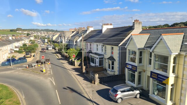


![Rose Hill, St Blazey St Blazey (Cornish: Lanndreth) is a small town in Cornwall, 3 miles (4.8 km) east of St Austell. The town takes its name from the Armenian Saint Blaise who, in Christian tradition, is believed to have "cure[d] toothache, sore throats and cattle diseases".
The local mining industries once dominated the town; historically copper and tin were mined in and around the parish, whilst more recently china clay has been the principal commodity mined. <a href="https://www.geograph.org.uk/photo/1701065">SX0554 : The Eden Project</a> is located about a mile and a half (2 km) from the centre of the town and the large number of visitors this attracts has led to the development of tourism in the town.
St Blazey. (2022, April 23). In Wikipedia. <span class="nowrap"><a title="https://en.wikipedia.org/wiki/St_Blazey" rel="nofollow ugc noopener" href="https://en.wikipedia.org/wiki/St_Blazey">Link</a><img style="margin-left:2px;" alt="External link" title="External link - shift click to open in new window" src="https://s1.geograph.org.uk/img/external.png" width="10" height="10"/></span>](https://s1.geograph.org.uk/geophotos/07/34/75/7347541_fcb16d1e.jpg)
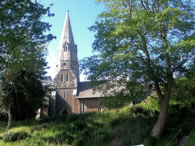
![Church Hill, St Blazey St Blazey (Cornish: Lanndreth) is a small town in Cornwall, 3 miles (4.8 km) east of St Austell. The town takes its name from the Armenian Saint Blaise who, in Christian tradition, is believed to have &quot;cure[d] toothache, sore throats and cattle diseases&quot;. The church, which was built between 1440 and 1445, is dedicated to Saint Blaise. It is a Grade II* listed building (List Entry Number:
1289700 <span class="nowrap"><a title="https://historicengland.org.uk/listing/the-list/list-entry/1289700" rel="nofollow ugc noopener" href="https://historicengland.org.uk/listing/the-list/list-entry/1289700">Link</a><img style="margin-left:2px;" alt="External link" title="External link - shift click to open in new window" src="https://s1.geograph.org.uk/img/external.png" width="10" height="10"/></span> Historic England).
The local mining industries once dominated the town; historically copper and tin were mined in and around the parish, whilst more recently china clay has been the principal commodity mined. <a href="https://www.geograph.org.uk/photo/1701065">SX0554 : The Eden Project</a> is located about a mile and a half (2 km) from the centre of the town and the large number of visitors this attracts has led to the development of tourism in the town.
St Blazey. (2022, April 23). In Wikipedia. <span class="nowrap"><a title="https://en.wikipedia.org/wiki/St_Blazey" rel="nofollow ugc noopener" href="https://en.wikipedia.org/wiki/St_Blazey">Link</a><img style="margin-left:2px;" alt="External link" title="External link - shift click to open in new window" src="https://s1.geograph.org.uk/img/external.png" width="10" height="10"/></span>](https://s3.geograph.org.uk/geophotos/07/34/75/7347543_38528efc.jpg)


St Blazey Gate is located at Grid Ref: SX0653 (Lat: 50.344886, Lng: -4.7279782)
Unitary Authority: Cornwall
Police Authority: Devon and Cornwall
What 3 Words
///accent.bypassed.props. Near Par, Cornwall
Nearby Locations
Related Wikis

St Blazey Gate
St Blazey Gate (Cornish: Yet Lanndreth) is a settlement in south Cornwall, England, United Kingdom in the civil parish of St Blaise. It is situated between...
Cornwall Coliseum
Cornwall Coliseum was a sport and entertainment venue located at Carlyon Bay near St Austell, Cornwall, England. It hosted exhibitions, tennis tournaments...

Carlyon Bay
Carlyon Bay (Cornish: Caryones, meaning forts) is a bay and a set of three beaches (Crinnis, Shorthorn and Polgaver) near St Austell on the south coast...

Carlyon
Carlyon (Cornish: Karleghyon, meaning fort of rock-slabs) is one of four new civil parishes created on 1 April 2009 for the St Austell area of south Cornwall...
Nearby Amenities
Located within 500m of 50.344886,-4.7279782Have you been to St Blazey Gate?
Leave your review of St Blazey Gate below (or comments, questions and feedback).