South End

Settlement in Lincolnshire

England

South End

Footpath to Goxhill
Footpath to Goxhill Credit: David Brown

South End is a quaint village located in Lincolnshire, England. Situated near the coast, this small community offers stunning views of the North Sea and is a popular destination for visitors looking to enjoy the seaside. The village is known for its charming cottages, traditional pubs, and picturesque beaches.

South End is a peaceful and tranquil place, making it an ideal spot for those seeking a relaxing getaway. The village is also home to a variety of shops, restaurants, and cafes, providing visitors with plenty of options for dining and shopping. Additionally, South End is surrounded by beautiful countryside, perfect for those who enjoy outdoor activities such as hiking, cycling, or simply taking leisurely strolls.

Overall, South End is a hidden gem in Lincolnshire, offering visitors a taste of traditional English village life with the added bonus of stunning coastal views. Whether you're looking to relax on the beach, explore the countryside, or simply enjoy the charm of a small village, South End has something to offer everyone.

If you have any feedback on the listing, please let us know in the comments section below.

South End Images

Images are sourced within 2km of 53.670026/-0.316766 or Grid Reference TA1120. Thanks to Geograph Open Source API. All images are credited.

Footpath to Goxhill
Footpath to Goxhill
Former RAF Goxhill: aerial 2024
Flooded East Halton Beck alongside Thornton Abbey: aerial 2024 (2)
Butterswood Level Crossing
Thornton Abbey: aerial 2022 (1)
Thornton Abbey: aerial 2022 (2)
Thornton Abbey: aerial, March 2022 (1)
Thornton Abbey: aerial, March 2022 (2)
Thornton Abbey: aerial, March 2022 (3)
Thornton Abbey: aerial, March 2022 (4)
Thornton Abbey: aerial, March 2022 (5)
Thornton Abbey: aerial, March 2022 (6)
Thornton Abbey: aerial, March 2022 (7)
Thornton Abbey: aerial, March 2022 (9)
Soilmark on field SW of Thornton Abbey: aerial 2022
Thornton Abbey: aerial, February 2022 (1)
Thornton Abbey Gatehouse
Show me another place!

South End is located at Grid Ref: TA1120 (Lat: 53.670026, Lng: -0.316766)

Division: Parts of Lindsey

Unitary Authority: North Lincolnshire

Police Authority: Humberside

What 3 Words

///editor.rank.opera. Near Goxhill, Lincolnshire

Nearby Locations

South End End, South

Related Wikis

Goxhill Hall

Goxhill Hall is a late 17th-century residence and a Grade II* Listed building in Goxhill, North Lincolnshire. A 14th to 15th-century Medieval hall joins...
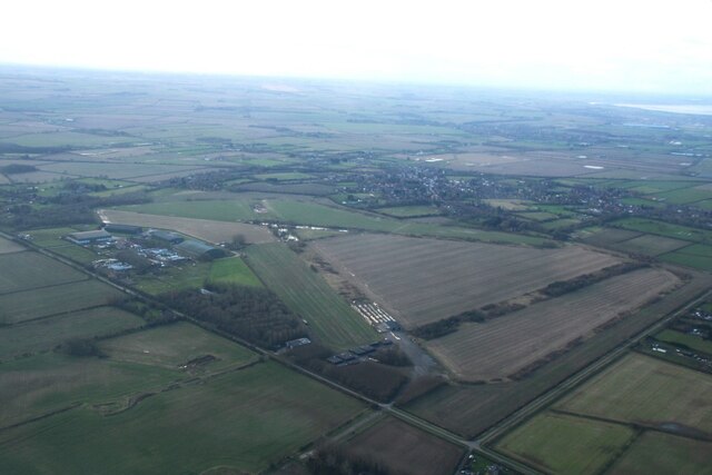
RAF Goxhill

Royal Air Force Goxhill or RAF Goxhill is a former Royal Air Force station located east of Goxhill, on the south bank of the Humber Estuary, opposite the...

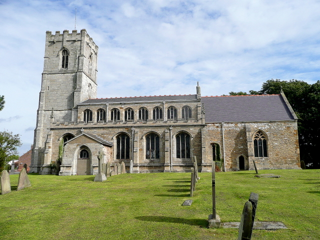
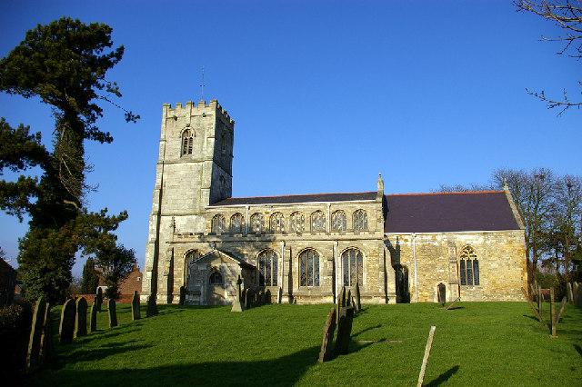
All Saints Church, Goxhill

All Saints Church is an Anglican church and Grade I Listed building in Goxhill, North Lincolnshire, England. == Architecture == The chancel dates to the...

Goxhill

Goxhill is a village and civil parish in North Lincolnshire, England. The population of the civil parish taken at the 2011 census was 2,290. It is situated...

Nearby Amenities

Located within 500m of 53.670026,-0.316766
Goxhill Hall
Archaeological Site: fortification
Historic: archaeological_site
Source: OS_OpenData_StreetView
Lat/Long: 53.6690914/-0.3224226
Telephone
Booth: K6
Covered: booth
Lat/Long: 53.6693455/-0.3181869
Post Box
Post Box Type: lamp
Lat/Long: 53.6693483/-0.3182367
Littlewick Farm
Place: farm
Source: Bing
Lat/Long: 53.6690636/-0.3168052
Pine Tree Farm
Place: farm
Source: Bing
Lat/Long: 53.6698582/-0.3160722
Priory Farm
Place: farm
Source: Bing
Lat/Long: 53.6692853/-0.3202208
South End Farm
Place: farm
Source: Bing
Lat/Long: 53.6687864/-0.3126097
South End
Place: village
Source: Bing
Lat/Long: 53.6694265/-0.3179565
Goxhill Priory
Historic: monastery
Lat/Long: 53.6680376/-0.3214073
Material: wood
Power: pole
Lat/Long: 53.6709567/-0.3227314
Material: wood
Power: pole
Lat/Long: 53.6706715/-0.3156316
Material: wood
Power: pole
Lat/Long: 53.6706055/-0.3140236
Material: wood
Power: pole
Lat/Long: 53.6705586/-0.3125431
Material: wood
Power: pole
Lat/Long: 53.6705054/-0.3110772
Material: wood
Power: pole
Lat/Long: 53.6704371/-0.3095269
Material: wood
Power: pole
Lat/Long: 53.6704379/-0.3094143
Generator Method: photovoltaic
Generator Output Electricity: yes
Generator Source: solar
Generator Type: solar_photovoltaic_panel
Location: roof
Power: generator
Lat/Long: 53.6697053/-0.3162579
Generator Method: photovoltaic
Generator Output Electricity: yes
Generator Source: solar
Generator Type: solar_photovoltaic_panel
Location: roof
Power: generator
Lat/Long: 53.6697029/-0.3162244
The data included in this document is from www.openstreetmap.org. The data is made available under ODbL.

Have you been to South End?

Leave your review of South End below (or comments, questions and feedback).