South Bramwith

Settlement in Yorkshire

England

South Bramwith

Recycled fencing This fence running across the River Don flood bank is largely constructed from old narrow-gauge rail lines, doubtless salvaged from the colliery nearby at Thorne.
Recycled fencing Credit: Lee Davidson

South Bramwith is a small village located in the county of Yorkshire, England. Situated in the Doncaster district, it is nestled between the towns of Barnby Dun and Sprotbrough. The village is positioned on the banks of the River Don, offering picturesque views and a tranquil atmosphere.

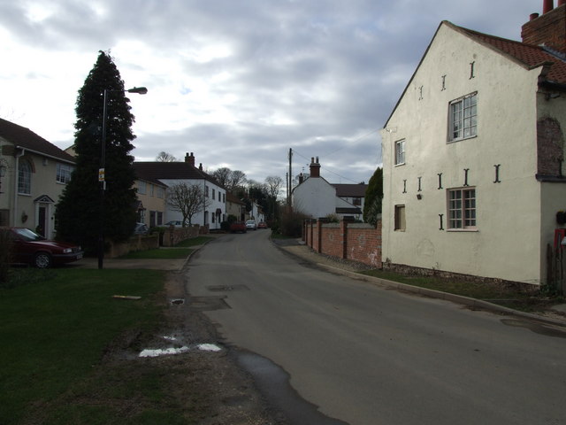
South Bramwith is known for its rural charm and close-knit community. The village is made up of a collection of traditional stone cottages, some of which date back several centuries. The architecture reflects the area's rich history and agricultural heritage.

The village is home to a population of around 300 residents, creating a tight-knit community where neighbors often know each other by name. The village center is characterized by a quaint church, St. Mary's, which serves as a gathering place for the locals.

The surrounding countryside provides ample opportunities for outdoor activities and exploration. The River Don is a popular spot for fishing, boating, and nature walks. The nearby Bramwith Locks, part of the Sheffield and South Yorkshire Navigation, offer a glimpse into the area's historic canal system.

Despite its peaceful setting, South Bramwith benefits from convenient transportation links. The village is located just a short drive away from the A1(M) motorway, providing easy access to larger towns and cities in the region.

Overall, South Bramwith offers a charming escape from the hustle and bustle of urban life, with its idyllic countryside, historic architecture, and close community ties.

If you have any feedback on the listing, please let us know in the comments section below.

South Bramwith Images

Images are sourced within 2km of 53.594494/-1.061532 or Grid Reference SE6211. Thanks to Geograph Open Source API. All images are credited.

Recycled fencing This fence running across the River Don flood bank is largely constructed from old narrow-gauge rail lines, doubtless salvaged from the colliery nearby at Thorne.
Recycled fencing
This fence running across the River Don flood bank is largely constructed from old narrow-gauge rail lines, doubtless salvaged from the colliery nearby at Thorne.
Oldfield Lane Flats, Staniforth
Track through the allotments Pictured from Oldfield Lane, Staniforth - through a locked security gate.
Track through the allotments
Pictured from Oldfield Lane, Staniforth - through a locked security gate.
Path to Staniforth crossing Old Field
Trees at the junction of Hall Lane and Doncaster Road
A view of Bramwith Hall, South Bramwith Grade II listed grand country house built in the eighteenth century and upgraded at various times throughout the nineteenth and twentieth centuries.
A view of Bramwith Hall, South Bramwith
Grade II listed grand country house built in the eighteenth century and upgraded at various times throughout the nineteenth and twentieth centuries.
A view of St Mary's Church, Kirk Bramwith It has a fine carved Norman doorway. This photo was taken from the gateway of The Old Rectory and  from the same spot as another Geograph visitor, even though the two pictures look very different: <a title="https://www.geograph.org.uk/photo/6830121" href="https://www.geograph.org.uk/photo/6830121">Link</a>
A view of St Mary's Church, Kirk Bramwith
It has a fine carved Norman doorway. This photo was taken from the gateway of The Old Rectory and from the same spot as another Geograph visitor, even though the two pictures look very different: Link
View across The River Don To Pump House Cottages, Kirk Bramwith.
View across The River Don
To Pump House Cottages, Kirk Bramwith.
On Bramwith Lane, west of South Bramwith
On Bramwith Lane near Tranmoor
Stubble I was walking into the sun. The church at Barnby Dun was but a silhouette then I turned to see the brightly illuminated stubble - like a vast army waiting in lines.
Stubble
I was walking into the sun. The church at Barnby Dun was but a silhouette then I turned to see the brightly illuminated stubble - like a vast army waiting in lines.
Start of the track to Lock House Farm You can see the farm through the trees.
Start of the track to Lock House Farm
You can see the farm through the trees.
The Norman doorway of Kirk Bramwith church. The church is dedicated to St Mary and is Grade II listed.
The Norman doorway of Kirk Bramwith church.
The church is dedicated to St Mary and is Grade II listed.
Disused  farm machinery In a neglected corner of South Farm, South Bramwith
Disused farm machinery
In a neglected corner of South Farm, South Bramwith
The River Don at South Bramwith
Disused doors at a disused farm At South Farm in the village of South Bramwith
Disused doors at a disused farm
At South Farm in the village of South Bramwith
Another view of St Mary's Church In Kirk Bramwith north of Doncaster
Another view of St Mary's Church
In Kirk Bramwith north of Doncaster
St Mary's church, Kirk Bramwith Although the main church is mostly from the 14th and 15th century the south doorway is Norman. It has wonderful arches with beakheads and chevrons
St Mary's church, Kirk Bramwith
Although the main church is mostly from the 14th and 15th century the south doorway is Norman. It has wonderful arches with beakheads and chevrons
Show me another place!

South Bramwith is located at Grid Ref: SE6211 (Lat: 53.594494, Lng: -1.061532)

Division: West Riding

Unitary Authority: Doncaster

Police Authority: South Yorkshire

What 3 Words

///faced.prance.newer. Near Stainforth, South Yorkshire

Related Wikis

Bramwith railway station

Bramwith railway station was a small station on the South Yorkshire Railway's line between Doncaster and Thorne. It served the village of Kirk Bramwith...

Kirk Bramwith

Kirk Bramwith is a village and civil parish in the Metropolitan Borough of Doncaster in South Yorkshire, England. It had a population of 200 in 2001,...

Bramwith railway station (West Riding and Grimsby Railway)

Bramwith (WR&G) railway station, which was named Barnby Dun on opening, believed to be 1872, due to its close proximity to the village of that name, took...

Ea Beck

The Ea Beck, also spelled Eaubeck or Eau Beck, is a small river in South Yorkshire, England, that flows eastwards into the River Don at Thorpe-in-Balne...

Nearby Amenities

Located within 500m of 53.594494,-1.061532
South Bramwith
Is In: South Yorkshire, England, UK
Place: village
Lat/Long: 53.5951474/-1.0617057
Bus Stop
Bramwith Lane/Fox Farm
Alt Name: Bramwith Lane/Fox Farm
Naptan AltCommonName: Bramwith Lane/Fox Farm
Naptan AtcoCode: 370040524
Naptan Bearing: NE
Naptan CommonName: Bramwith Lane/Fox Farm
Naptan Indicator: 40524
Naptan Landmark: Fox Farm
Naptan PlusbusZoneRef: ROTHCEN
Naptan Street: Bramwith Lane
Naptan Verified: no
Source: naptan_import
Lat/Long: 53.5952585/-1.0622811
Bus Stop
Bramwith Lane/Fox Farm
Alt Name: Bramwith Lane/Fox Farm
Naptan AltCommonName: Bramwith Lane/Fox Farm
Naptan AtcoCode: 370040525
Naptan Bearing: SW
Naptan CommonName: Bramwith Lane/Fox Farm
Naptan Indicator: 40525
Naptan Landmark: FOX FARM
Naptan PlusbusZoneRef: ROTHCEN
Naptan Street: Bramwith Lane
Naptan Verified: no
Source: naptan_import
Lat/Long: 53.5950874/-1.0622396
The data included in this document is from www.openstreetmap.org. The data is made available under ODbL.

Have you been to South Bramwith?

Leave your review of South Bramwith below (or comments, questions and feedback).