Bleasby
Settlement in Lincolnshire West Lindsey
England
Bleasby

Bleasby is a small village located in Lincolnshire, England. It is situated approximately 7 miles east of the city of Lincoln and is part of the West Lindsey district. The village is surrounded by picturesque countryside, with rolling hills and farmland making up the majority of the landscape.
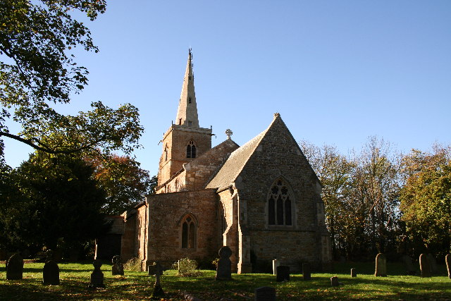
Bleasby is a historic village, with evidence of settlement dating back to Roman times. The village is home to a mix of traditional stone cottages, modern houses, and historic buildings, including the Grade II listed St. Lawrence's Church.
The village has a primary school, a village hall, and a pub, providing essential amenities for its residents. Bleasby also has a strong sense of community, with various events and activities organized throughout the year.
The village is well-connected by road, with easy access to the A57 and A46, making it convenient for residents to travel to nearby towns and cities. Overall, Bleasby is a charming and peaceful village, offering a tranquil setting for those looking to escape the hustle and bustle of city life.
If you have any feedback on the listing, please let us know in the comments section below.
Bleasby Images
Images are sourced within 2km of 53.346468/-0.302799 or Grid Reference TF1384. Thanks to Geograph Open Source API. All images are credited.

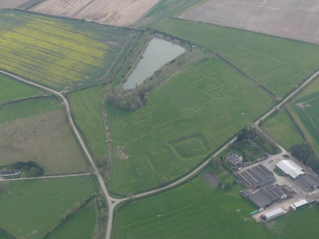


![Linwood Moats: aerial 2023 (1) See: <span class="nowrap"><a title="https://www.heritagegateway.org.uk/Gateway/Results_Single.aspx?uid=MLI50300&amp;resourceID=1006" rel="nofollow ugc noopener" href="https://www.heritagegateway.org.uk/Gateway/Results_Single.aspx?uid=MLI50300&amp;resourceID=1006">Link</a><img style="margin-left:2px;" alt="External link" title="External link - shift click to open in new window" src="https://s1.geograph.org.uk/img/external.png" width="10" height="10"/></span>
Probably the remains of the larger of two manors, recorded in the Domesday Book, and held by Alfred of Lincoln... there was a sharp decline [in population] on the 17th century... In 1607 the manor house was &#039;decayed&#039;... The earthworks used to be scheduled, but have been ploughed out, and so are no longer scheduled.&quot;
See also <a href="https://www.geograph.org.uk/photo/6340097">TF1185 : Moated site, Linwood: aerial 2019 (1)</a>],
<a href="https://www.geograph.org.uk/photo/6340104">TF1185 : Moated site to the south of Linwood: aerial 2019 (2)</a> and
<a href="https://www.geograph.org.uk/photo/6340108">TF1185 : Moated site to the south of Linwood: aerial 2019 (3)</a>.](https://s0.geograph.org.uk/geophotos/07/42/72/7427216_cfb4e0f1.jpg)
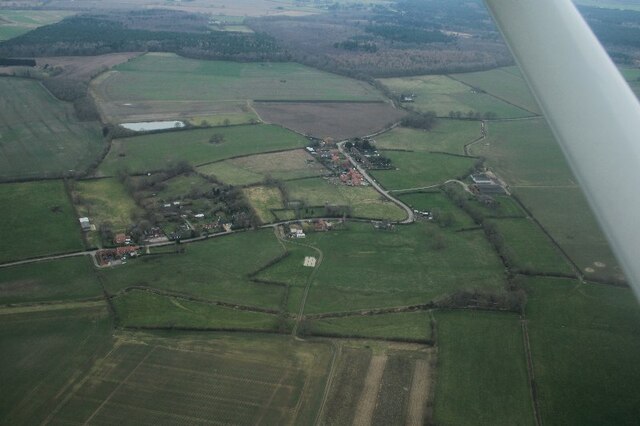
![Linwood Moats: aerial 2023 (2) See: <span class="nowrap"><a title="https://www.heritagegateway.org.uk/Gateway/Results_Single.aspx?uid=MLI50300&amp;resourceID=1006" rel="nofollow ugc noopener" href="https://www.heritagegateway.org.uk/Gateway/Results_Single.aspx?uid=MLI50300&amp;resourceID=1006">Link</a><img style="margin-left:2px;" alt="External link" title="External link - shift click to open in new window" src="https://s1.geograph.org.uk/img/external.png" width="10" height="10"/></span>
&quot;Probably the remains of the larger of two manors, recorded in the Domesday Book, and held by Alfred of Lincoln... there was a sharp decline [in population] on the 17th century... In 1607 the manor house was &#039;decayed&#039;... The earthworks used to be scheduled, but have been ploughed out, and so are no longer scheduled.&quot;
See also <a href="https://www.geograph.org.uk/photo/6340097">TF1185 : Moated site, Linwood: aerial 2019 (1)</a>],
<a href="https://www.geograph.org.uk/photo/7427216">TF1185 : Linwood Moats: aerial 2023 (1)</a>,
<a href="https://www.geograph.org.uk/photo/6340104">TF1185 : Moated site to the south of Linwood: aerial 2019 (2)</a> and
<a href="https://www.geograph.org.uk/photo/6340108">TF1185 : Moated site to the south of Linwood: aerial 2019 (3)</a>.](https://s3.geograph.org.uk/geophotos/07/42/72/7427231_3738b5c2.jpg)


Bleasby is located at Grid Ref: TF1384 (Lat: 53.346468, Lng: -0.302799)
Division: Parts of Lindsey
Administrative County: Lincolnshire
District: West Lindsey
Police Authority: Lincolnshire
What 3 Words
///appealing.spring.coarser. Near Market Rasen, Lincolnshire
Nearby Locations
Related Wikis

Legsby
Legsby (otherwise Legesby) is a small village and civil parish in the West Lindsey district of Lincolnshire, England. The population of the civil parish...

Lissington
Lissington is a village and civil parish in the West Lindsey district of Lincolnshire, England. The population of the civil parish at the 2011 census was...

West Torrington
West Torrington is a small hamlet in the East Lindsey district of Lincolnshire, England. It is situated on the edge of Bleasby Moor and 3 miles (4.8 km...
Linwood, Lincolnshire
Linwood is a small village and civil parish in the West Lindsey district of Lincolnshire, England, on the minor B1202 road about 2 miles (3 km) south from...
Nearby Amenities
Located within 500m of 53.346468,-0.302799Have you been to Bleasby?
Leave your review of Bleasby below (or comments, questions and feedback).