Shoreditch

Settlement in Somerset Somerset West and Taunton

England

Shoreditch

Kibbear Massive tractor activity in this view looking east by north from a footpath. The M5, which cuts diagonally right across this square, can be seen on the right about 700m from the camera. in the distance, Stoke Wood.
Kibbear Credit: Derek Harper

Shoreditch is a small village located in the county of Somerset, in southwestern England. Situated approximately 10 miles north of Taunton, it lies within the district of West Somerset. With a population of around 1,000 residents, Shoreditch is known for its picturesque countryside and charming rural atmosphere.

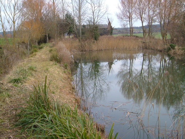
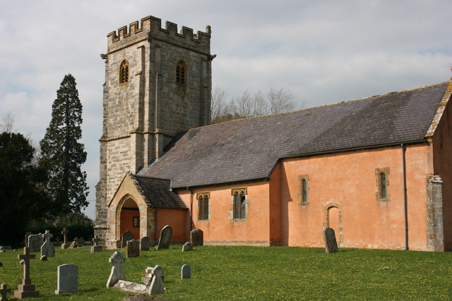
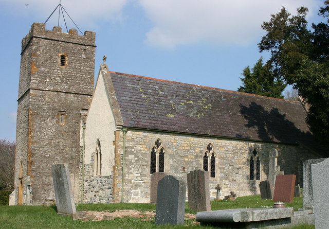
The village is surrounded by rolling hills and green fields, creating a beautiful backdrop for outdoor activities such as hiking and cycling. It is also home to several historic buildings, including the Grade II listed St. Mary's Church, which dates back to the 13th century and showcases stunning architectural features.

Shoreditch offers a range of amenities for its residents and visitors. The village has a primary school, a village hall, and a local pub, providing a sense of community and social gathering spaces. The nearby town of Taunton offers additional services and facilities, including shops, supermarkets, and healthcare facilities.

For nature enthusiasts, Shoreditch is located close to the Quantock Hills Area of Outstanding Natural Beauty, where visitors can explore miles of scenic trails, ancient woodlands, and enjoy breathtaking views. The village is also within easy reach of the stunning coastline of the Bristol Channel, offering opportunities for seaside walks and water sports activities.

Overall, Shoreditch in Somerset is a tranquil and picturesque village that offers a peaceful countryside escape, while still providing access to modern amenities and nearby natural attractions.

If you have any feedback on the listing, please let us know in the comments section below.

Shoreditch Images

Images are sourced within 2km of 50.993596/-3.080491 or Grid Reference ST2422. Thanks to Geograph Open Source API. All images are credited.

Kibbear Massive tractor activity in this view looking east by north from a footpath. The M5, which cuts diagonally right across this square, can be seen on the right about 700m from the camera. in the distance, Stoke Wood.
Kibbear
Massive tractor activity in this view looking east by north from a footpath. The M5, which cuts diagonally right across this square, can be seen on the right about 700m from the camera. in the distance, Stoke Wood.
King's College, Taunton This square contains three sizeable academic institutions, and King's College's main building, mid-Victorian Gothic, is certainly the most impressive. Architectural details at <span class="nowrap"><a title="http://www.tauntondeane.gov.uk/tdbcsites/HER/her_lb/lbdets.asp?id=002028" rel="nofollow ugc noopener" href="http://www.tauntondeane.gov.uk/tdbcsites/HER/her_lb/lbdets.asp?id=002028">Link</a><img style="margin-left:2px;" alt="External link" title="External link - shift click to open in new window" src="https://s1.geograph.org.uk/img/external.png" width="10" height="10"/></span> . Viewed from the SW.
King's College, Taunton
This square contains three sizeable academic institutions, and King's College's main building, mid-Victorian Gothic, is certainly the most impressive. Architectural details at LinkExternal link . Viewed from the SW.
Higher Holway, Taunton A couple take their dog for a walk in this little area of green space between the residential suburb of Holway and the M5, foreground. View looking NNW from the Haydon Road bridge over the motorway. 2:36 pm.
Higher Holway, Taunton
A couple take their dog for a walk in this little area of green space between the residential suburb of Holway and the M5, foreground. View looking NNW from the Haydon Road bridge over the motorway. 2:36 pm.
Haydon House, near Taunton Seventeenth century house and brick outbuilding ("a rare early example of high quality brick building in Somerset" according to <span class="nowrap"><a title="http://www.britishlistedbuildings.co.uk/en-270907-outbuilding-with-wall-adjoining-south-ea" rel="nofollow ugc noopener" href="http://www.britishlistedbuildings.co.uk/en-270907-outbuilding-with-wall-adjoining-south-ea">Link</a><img style="margin-left:2px;" alt="External link" title="External link - shift click to open in new window" src="https://s1.geograph.org.uk/img/external.png" width="10" height="10"/></span> ). See <span class="nowrap"><a title="http://www.britishlistedbuildings.co.uk/en-270906-haydon-house-stoke-st-mary-somerset" rel="nofollow ugc noopener" href="http://www.britishlistedbuildings.co.uk/en-270906-haydon-house-stoke-st-mary-somerset">Link</a><img style="margin-left:2px;" alt="External link" title="External link - shift click to open in new window" src="https://s1.geograph.org.uk/img/external.png" width="10" height="10"/></span> for details of the house. View from the NW at 2:40 pm.
Haydon House, near Taunton
Seventeenth century house and brick outbuilding ("a rare early example of high quality brick building in Somerset" according to LinkExternal link ). See LinkExternal link for details of the house. View from the NW at 2:40 pm.
Pond near Netherclay This artificial pond (the little stream that feeds it runs along the ditch to left) is in the midst of almost level large open fields that dominate the square. Looking ESE. 3:21 pm
Pond near Netherclay
This artificial pond (the little stream that feeds it runs along the ditch to left) is in the midst of almost level large open fields that dominate the square. Looking ESE. 3:21 pm
Taunton racecourse The National Hunt course is on level ground about 2 miles outside the town at Orchard Portman. The racetrack is crossed by three separate footpaths. This view looks SW at hurdles and fences.
Taunton racecourse
The National Hunt course is on level ground about 2 miles outside the town at Orchard Portman. The racetrack is crossed by three separate footpaths. This view looks SW at hurdles and fences.
Orchard Wood from lane near Orchard Portman A ditched lane approaches outlying spurs of the Blackdown Hills. View to SE.
Orchard Wood from lane near Orchard Portman
A ditched lane approaches outlying spurs of the Blackdown Hills. View to SE.
Corfe Barton House seen from lane to Heale. Looking SW.
Corfe Barton
House seen from lane to Heale. Looking SW.
Stoke Road The junction of Broughton Lane with Stoke Road, in the flat land between Taunton and the Blackdown Hills (from which Stoke Wood, in the background, juts out). Unfortunately, the trimmer used to top the hedge on the left, which will have been raised to avoid the signpost, must have also missed a stem nearby, so that the sign is mostly obscured: it points to Shoreditch, and Orchard Portman. The buildings visible further along the lane are the beginnings of Stoke St Mary.
Stoke Road
The junction of Broughton Lane with Stoke Road, in the flat land between Taunton and the Blackdown Hills (from which Stoke Wood, in the background, juts out). Unfortunately, the trimmer used to top the hedge on the left, which will have been raised to avoid the signpost, must have also missed a stem nearby, so that the sign is mostly obscured: it points to Shoreditch, and Orchard Portman. The buildings visible further along the lane are the beginnings of Stoke St Mary.
Shoreditch Shoreditch Farm and an outhouse in the process of renovation are at the junction of Broughton Lane with the road over the Blackdown Hills from Staple Fitzpaine to Taunton.
Shoreditch
Shoreditch Farm and an outhouse in the process of renovation are at the junction of Broughton Lane with the road over the Blackdown Hills from Staple Fitzpaine to Taunton.
Cider orchard at Haygrass There are several large orchards in this area, reflecting a history of cider-making. This apple orchard is alongside Killams Avenue near Haygrass House.
Cider orchard at Haygrass
There are several large orchards in this area, reflecting a history of cider-making. This apple orchard is alongside Killams Avenue near Haygrass House.
Paths at Killams Combined foot- and cyclepaths have been built around the edge of the estate on the southern edge of Taunton's suburbs. This photo is taken from Killams Avenue, and there is modern housing to the right and left. The parapets just beyond the waste bin indicate the crossing of the Black Brook, which flows to the right. Ahead is farmland in the direction of Cutliff Farm.
Paths at Killams
Combined foot- and cyclepaths have been built around the edge of the estate on the southern edge of Taunton's suburbs. This photo is taken from Killams Avenue, and there is modern housing to the right and left. The parapets just beyond the waste bin indicate the crossing of the Black Brook, which flows to the right. Ahead is farmland in the direction of Cutliff Farm.
Fosgrove A hamlet in Taunton Deane centred around a farm and small country house, and on a particularly circuitous lane. The view here is from the same lane after it has performed two right-angled bends. In the background is Orchard Wood, an outlier of the Blackdown Hills.
Fosgrove
A hamlet in Taunton Deane centred around a farm and small country house, and on a particularly circuitous lane. The view here is from the same lane after it has performed two right-angled bends. In the background is Orchard Wood, an outlier of the Blackdown Hills.
Path to Cotlake Hill The footpath from Kibbear follows the hedge around this ploughed field on its way to the modest eminence of Cotlake Hill.
Path to Cotlake Hill
The footpath from Kibbear follows the hedge around this ploughed field on its way to the modest eminence of Cotlake Hill.
Martin Pipe in parade ring Martin Pipe in his final year as a trainer at Taunton Racecourse.
Martin Pipe in parade ring
Martin Pipe in his final year as a trainer at Taunton Racecourse.
Stoke St. Mary telephone box This is No 1 of 42 images of BT telephone boxes in Taunton Deane which BT is trying to cull due to their claimed 'lack of use'.  If you would like to see this phone box stay in situ, please email savethispayphone@ukpayphone.com
Stoke St. Mary telephone box
This is No 1 of 42 images of BT telephone boxes in Taunton Deane which BT is trying to cull due to their claimed 'lack of use'. If you would like to see this phone box stay in situ, please email savethispayphone@ukpayphone.com
Apples, Haygrass See <a href="https://www.geograph.org.uk/photo/241362">ST2321 : Cider orchard at Haygrass</a>. These apples are in the northeast corner of the orchard to the north, beside the footpath from the racecourse to Killam's Lane.
Apples, Haygrass
See ST2321 : Cider orchard at Haygrass. These apples are in the northeast corner of the orchard to the north, beside the footpath from the racecourse to Killam's Lane.
New gate to footpath The footpath west from Killam's Lane at Haygrass has been slightly diverted around the edge of the orchard on the left, alongside a tiny tributary of the Black Brook, and this modern kissing gate shows the way.
New gate to footpath
The footpath west from Killam's Lane at Haygrass has been slightly diverted around the edge of the orchard on the left, alongside a tiny tributary of the Black Brook, and this modern kissing gate shows the way.
Show me another place!

Shoreditch is located at Grid Ref: ST2422 (Lat: 50.993596, Lng: -3.080491)

Administrative County: Somerset

District: Somerset West and Taunton

Police Authority: Avon and Somerset

What 3 Words

///vibrates.distract.installs. Near Taunton, Somerset

Nearby Locations

Shoreditch

Related Wikis

Heart Somerset

Heart Somerset (formerly Somerset's Orchard FM) was an Independent Local Radio station serving Somerset, England. Originally owned by (and officially remains...

St Michael's Church, Orchard Portman

The Anglican Church of St Michael in Orchard Portman, Somerset, England, dates from the Norman period. It is a Grade II* listed building. == History... ==

Church of St Thomas, Thurlbear

The Church of St Thomas in the village of Thurlbear, which is in the parish of Orchard Portman, Somerset, England, dates from the 12th century. It has...

Taunton Racecourse

Taunton Racecourse is a thoroughbred horse racing venue located in Orchard Portman, two miles south of Taunton, Somerset, England. Opened in 1927, Taunton...

Orchard Portman

Orchard Portman is a village and civil parish in Somerset, England, situated 2 miles (3.2 km) south of Taunton. The village has a population of 150.The...

Bishop Fox's School

Bishop Fox's School is a mixed secondary school located in Taunton, Somerset, England. == History == The school traces its history back to the Taunton...

Taunton Flower Show

Taunton Flower Show is an annual flower show held in Vivary Park, Taunton, Somerset, England. It has been described as "The Chelsea of the West", and attracts...

Stoke St Mary

Stoke St Mary is a village and civil parish in Somerset, England, situated 2 miles (3.2 km) south east of Taunton. == History == The earliest recorded...

Nearby Amenities

Located within 500m of 50.993596,-3.080491
Power: pole
Lat/Long: 50.9919299/-3.0868224
Power: pole
Lat/Long: 50.9926992/-3.0849306
Power: pole
Lat/Long: 50.9927228/-3.0859495
Give Way
Direction: backward
Lat/Long: 50.9940806/-3.0788919
Post Box
Operator: Royal Mail
Operator Wikidata: Q638098
Post Box Type: wall
Lat/Long: 50.9900509/-3.0769155
Shoreditch
Is In: Somerset, England, United Kingdom
Place: hamlet
Source: Bing
Lat/Long: 50.9946766/-3.081449
Crossing
Crossing Island: yes
Lat/Long: 50.9945413/-3.0817041
Give Way
Direction: backward
Lat/Long: 50.9945599/-3.0817748
Give Way
Direction: backward
Lat/Long: 50.9928553/-3.0770136
Historic: milepost
Inscription: Taunton 2 Miles
Lat/Long: 50.993102/-3.0825071
Post Box
Operator: Royal Mail
Operator Wikidata: Q638098
Post Box Type: lamp
Ref: TA3 284
Royal Cypher: EIIR
Royal Cypher Wikidata: Q33102113
Lat/Long: 50.9941349/-3.0821056
Historic: milestone
Inscription: 2 Miles to Taunton
Lat/Long: 50.9941588/-3.0790922
Power: pole
Lat/Long: 50.9950353/-3.0863619
Power: pole
Lat/Long: 50.9944394/-3.0853684
Power: pole
Lat/Long: 50.9935179/-3.0842043
NHS Covid19 Mass Vaccination Centre
Healthcare: vaccination_centre
Note: precise location in building required
Start Date: 18/01/2021
Vaccination: covid19
Lat/Long: 50.9906171/-3.08413
The data included in this document is from www.openstreetmap.org. The data is made available under ODbL.

Have you been to Shoreditch?

Leave your review of Shoreditch below (or comments, questions and feedback).