Blaen-pant

Settlement in Cardiganshire

Wales

Blaen-pant

Scotland Hill Trig has been uprooted and relocated to the SSE gate corner. Up track from SE and cattle pasture gates.to find trig on way to TUMP summit. It doesn't get much better than bagging Scotland Hill in Wales.
Name: Scotland Hill
Hill number: 15420
Height:185m / 607ft
Parent (Ma/M): 2221  Rhos Ymryson
Section:31C: South-West Wales
County/UA: Cardiganshire [Ceredigion] (CoU)
Class: Tump (100-199m)
Grid ref:SN248453 (est)
Drop: 48m
Col:137m  SN270486
Scotland Hill Credit: Rude Health

Blaen-pant is a small village located in the county of Cardiganshire, Wales. Situated in the picturesque countryside, it is surrounded by rolling hills and lush green meadows. The village is nestled in the upper Teifi Valley, near the banks of the River Teifi.

The settlement dates back centuries and has a rich history. It was primarily an agricultural community, with farming being the main occupation of the villagers. The landscape is dotted with traditional Welsh farms and a few quaint cottages, giving it a charming and rustic ambiance.

Blaen-pant offers a peaceful and tranquil environment, away from the hustle and bustle of city life. The stunning natural beauty of the area attracts visitors who come to enjoy the breathtaking scenery and explore the nearby walking trails and hiking routes.

Despite its small size, the village has a sense of community, with a few local amenities serving the residents. These include a small village shop, a pub, and a community hall where various events and gatherings take place throughout the year.

The village is also in close proximity to other attractions in Cardiganshire. The nearby town of Cardigan offers a wider range of amenities, including shops, restaurants, and historical landmarks. Additionally, the stunning coastline of Cardigan Bay is just a short drive away, providing opportunities for beach walks, water sports, and wildlife spotting.

Overall, Blaen-pant is a hidden gem in the heart of Cardiganshire, offering a peaceful retreat in a beautiful natural setting.

If you have any feedback on the listing, please let us know in the comments section below.

Blaen-pant Images

Images are sourced within 2km of 52.069937/-4.550794 or Grid Reference SN2544. Thanks to Geograph Open Source API. All images are credited.

Scotland Hill Trig has been uprooted and relocated to the SSE gate corner. Up track from SE and cattle pasture gates.to find trig on way to TUMP summit. It doesn't get much better than bagging Scotland Hill in Wales.
Name: Scotland Hill
Hill number: 15420
Height:185m / 607ft
Parent (Ma/M): 2221  Rhos Ymryson
Section:31C: South-West Wales
County/UA: Cardiganshire [Ceredigion] (CoU)
Class: Tump (100-199m)
Grid ref:SN248453 (est)
Drop: 48m
Col:137m  SN270486
Scotland Hill
Trig has been uprooted and relocated to the SSE gate corner. Up track from SE and cattle pasture gates.to find trig on way to TUMP summit. It doesn't get much better than bagging Scotland Hill in Wales. Name: Scotland Hill Hill number: 15420 Height:185m / 607ft Parent (Ma/M): 2221 Rhos Ymryson Section:31C: South-West Wales County/UA: Cardiganshire [Ceredigion] (CoU) Class: Tump (100-199m) Grid ref:SN248453 (est) Drop: 48m Col:137m SN270486
Pen Bryn-Bwa Trig Point Trig has been uprooted from the summit of Scotland Hill and relocated to the SSE gate corner. Up track from SE + cattle pasture gates.to find trig on way to TUMP summit. It doesn't get much better than bagging Scotland Hill in Wales.
Pen Bryn-Bwa Trig Point
Trig has been uprooted from the summit of Scotland Hill and relocated to the SSE gate corner. Up track from SE + cattle pasture gates.to find trig on way to TUMP summit. It doesn't get much better than bagging Scotland Hill in Wales.
Ordnance Survey Cut Mark This OS cut mark can be found at the entrance through the wall to Noyadd Trefawr. It marks a point 136.005m above mean sea level. <a title="https://www.geograph.org.uk/photo/4668540" href="https://www.geograph.org.uk/photo/4668540">Link</a>
Ordnance Survey Cut Mark
This OS cut mark can be found at the entrance through the wall to Noyadd Trefawr. It marks a point 136.005m above mean sea level. Link
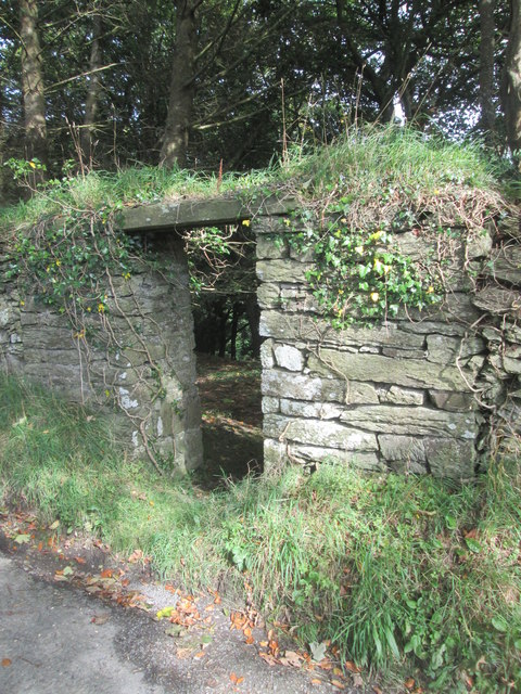
Entrance in Wall There is an OS cut mark to the right of the entrance. <a title="https://www.geograph.org.uk/photo/4668534" href="https://www.geograph.org.uk/photo/4668534">Link</a>
Entrance in Wall
There is an OS cut mark to the right of the entrance. Link
The uprooted and moved Pen Bryn-Bwa Triangulation Pillar This pillar used to stand on the Tumuli at SN 2487 4537 but now stands abandoned in a nearby gateway.
Looking westward.
The uprooted and moved Pen Bryn-Bwa Triangulation Pillar
This pillar used to stand on the Tumuli at SN 2487 4537 but now stands abandoned in a nearby gateway. Looking westward.
War memorial,  Neuadd Cross Memorial on B4570 (foreground) at crossroads; The 'one way' sign detracts from the setting and seems superfluous for a short stretch of road.
War memorial, Neuadd Cross
Memorial on B4570 (foreground) at crossroads; The 'one way' sign detracts from the setting and seems superfluous for a short stretch of road.
Road to Beulah Minor road (direction sign obscured) from Neuadd Cross.
Road to Beulah
Minor road (direction sign obscured) from Neuadd Cross.
Old Milestone by the B4570, Neuadd Cross, Beulah parish Cardigan tombstone by the B4570, in parish of Beulah (Ceredigion District), West of Neuadd Cross, opposite Ffynnoncripil, on verge under bracken.

Inscription reads:-
TO
CARDIGAN
5 MILES
{arrow->}
Carved bench mark on centre face.

Grade II listed by Cadw.
Reference Number: 17966 <span class="nowrap"><a title="https://cadwpublic-api.azurewebsites.net/reports/listedbuilding/FullReport?lang=&id=17966" rel="nofollow ugc noopener" href="https://cadwpublic-api.azurewebsites.net/reports/listedbuilding/FullReport?lang=&id=17966">Link</a><img style="margin-left:2px;" alt="External link" title="External link - shift click to open in new window" src="https://s1.geograph.org.uk/img/external.png" width="10" height="10"/></span>

Surveyed

Milestone Society National ID: CRD_CALA05
Old Milestone by the B4570, Neuadd Cross, Beulah parish
Cardigan tombstone by the B4570, in parish of Beulah (Ceredigion District), West of Neuadd Cross, opposite Ffynnoncripil, on verge under bracken. Inscription reads:- TO CARDIGAN 5 MILES {arrow->} Carved bench mark on centre face. Grade II listed by Cadw. Reference Number: 17966 LinkExternal link Surveyed Milestone Society National ID: CRD_CALA05
Old Milestone by the B4570, Nantgwgan, Beulah parish Cardigan tombstone by the B4570, in parish of Beulah (Ceredigion District), Nantgwgan, South of Ponthirwaun, on verge.

Inscription reads:-
TO
CARDIGAN
6 MILES
Carved bench mark middle face.

Grade II listed by Cadw.
Reference Number: 17974 <span class="nowrap"><a title="https://cadwpublic-api.azurewebsites.net/reports/listedbuilding/FullReport?lang=&id=17974" rel="nofollow ugc noopener" href="https://cadwpublic-api.azurewebsites.net/reports/listedbuilding/FullReport?lang=&id=17974">Link</a><img style="margin-left:2px;" alt="External link" title="External link - shift click to open in new window" src="https://s1.geograph.org.uk/img/external.png" width="10" height="10"/></span>

Surveyed

Milestone Society National ID: CRD_CALA06
Old Milestone by the B4570, Nantgwgan, Beulah parish
Cardigan tombstone by the B4570, in parish of Beulah (Ceredigion District), Nantgwgan, South of Ponthirwaun, on verge. Inscription reads:- TO CARDIGAN 6 MILES Carved bench mark middle face. Grade II listed by Cadw. Reference Number: 17974 LinkExternal link Surveyed Milestone Society National ID: CRD_CALA06
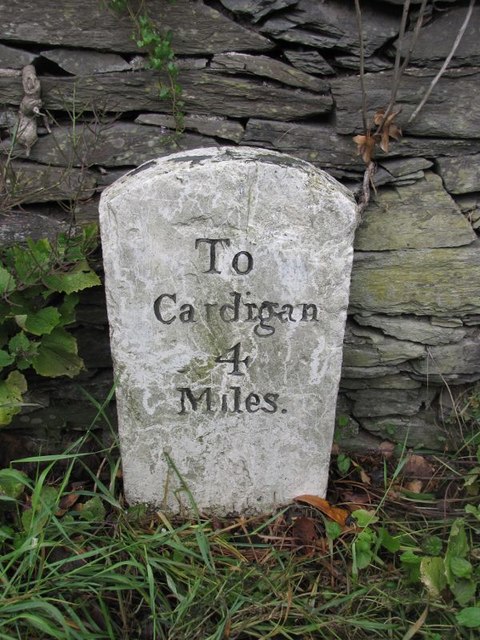
Old Milestone by the A484, Llwynduris Farm, Beulah parish Cardigan tombstone by the A484, in parish of Beulah (Ceredigion District), Llwynduris Farm, Southwest of Llandygwydd, on verge against wall, East side of road.

Inscription reads:-
To
Cardigan
4
Miles

Grade II listed by Cadw.
Reference Number: 17960 <span class="nowrap"><a title="https://cadwpublic-api.azurewebsites.net/reports/listedbuilding/FullReport?lang=&id=17960" rel="nofollow ugc noopener" href="https://cadwpublic-api.azurewebsites.net/reports/listedbuilding/FullReport?lang=&id=17960">Link</a><img style="margin-left:2px;" alt="External link" title="External link - shift click to open in new window" src="https://s1.geograph.org.uk/img/external.png" width="10" height="10"/></span>

Surveyed

Milestone Society National ID: CRD_CACM04
Old Milestone by the A484, Llwynduris Farm, Beulah parish
Cardigan tombstone by the A484, in parish of Beulah (Ceredigion District), Llwynduris Farm, Southwest of Llandygwydd, on verge against wall, East side of road. Inscription reads:- To Cardigan 4 Miles Grade II listed by Cadw. Reference Number: 17960 LinkExternal link Surveyed Milestone Society National ID: CRD_CACM04
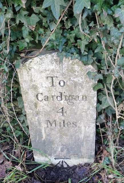
Old Milestone by the B4570, Llangoedmor parish Cardigan tombstone by the B4570, in parish of Llangoedmor (Ceredigion District), West of Penllwyndu Inn, on verge under hedge, Southeast side of road.

Inscription reads:-
TO
CARDIGAN
4 MILES
Carved benchmark on lower face. 

Grade II listed by Cadw.
Reference Number: 14792 <span class="nowrap"><a title="https://cadwpublic-api.azurewebsites.net/reports/listedbuilding/FullReport?lang=&id=14792" rel="nofollow ugc noopener" href="https://cadwpublic-api.azurewebsites.net/reports/listedbuilding/FullReport?lang=&id=14792">Link</a><img style="margin-left:2px;" alt="External link" title="External link - shift click to open in new window" src="https://s1.geograph.org.uk/img/external.png" width="10" height="10"/></span>

Surveyed

Milestone Society National ID: CRD_CALA04
Old Milestone by the B4570, Llangoedmor parish
Cardigan tombstone by the B4570, in parish of Llangoedmor (Ceredigion District), West of Penllwyndu Inn, on verge under hedge, Southeast side of road. Inscription reads:- TO CARDIGAN 4 MILES Carved benchmark on lower face. Grade II listed by Cadw. Reference Number: 14792 LinkExternal link Surveyed Milestone Society National ID: CRD_CALA04
Ordnance Survey Cut Mark This OS cut mark can be found on the water tap at the road junction. It marks a point 118.909m above mean sea level.
Ordnance Survey Cut Mark
This OS cut mark can be found on the water tap at the road junction. It marks a point 118.909m above mean sea level.
Ordnance Survey Cut Mark This hidden and damaged OS cut mark can be found on the gatepost east side of the road. It marks a point 101.517m above mean sea level.
Ordnance Survey Cut Mark
This hidden and damaged OS cut mark can be found on the gatepost east side of the road. It marks a point 101.517m above mean sea level.
Ordnance Survey Cut Mark This OS cut mark can be found on the gatepost NW side of the road. It marks a point 133.698m above mean sea level.
Ordnance Survey Cut Mark
This OS cut mark can be found on the gatepost NW side of the road. It marks a point 133.698m above mean sea level.
Milestone - Cardigan 4 The OS cut mark on the stone marks a point 19.198m above mean sea level.
Milestone - Cardigan 4
The OS cut mark on the stone marks a point 19.198m above mean sea level.
Ordnance Survey Cut Mark This OS cut mark can be found on Pant-y-Llys. It marks a point 113.016m above mean sea level.
Ordnance Survey Cut Mark
This OS cut mark can be found on Pant-y-Llys. It marks a point 113.016m above mean sea level.
Ordnance Survey Cut Mark This OS cut mark can be found on the remains of the porch of the ruin of St Tygwydd's Church. It marks a point 44.720m above mean sea level.
Ordnance Survey Cut Mark
This OS cut mark can be found on the remains of the porch of the ruin of St Tygwydd's Church. It marks a point 44.720m above mean sea level.
Ordnance Survey Cut Mark This OS cut mark can be found on Pant Glas Cottage. It marks a point 68.753m above mean sea level.
Ordnance Survey Cut Mark
This OS cut mark can be found on Pant Glas Cottage. It marks a point 68.753m above mean sea level.
Show me another place!

Blaen-pant is located at Grid Ref: SN2544 (Lat: 52.069937, Lng: -4.550794)

Unitary Authority: Ceredigion

Police Authority: Dyfed Powys

What 3 Words

///teaching.ringers.anthems. Near Newcastle Emlyn, Ceredigion

Nearby Locations

Long Wood Blaen-pant

Related Wikis

Blaen-pant

Blaen-pant is a small village in the community of Beulah, Ceredigion, Wales, which is 71.5 miles (115 km) from Cardiff and 192.8 miles (310.3 km) from...

Llandygwydd

Llandygwydd is a small settlement in Ceredigion, west Wales, between Newcastle Emlyn and the town of Cardigan. == Amenities & History == A small stream...

Ponthirwaun

Ponthirwaun is a hamlet in the community of Beulah, Ceredigion, Wales, which is 71.3 miles (114.8 km) from Cardiff and 192.5 miles (309.7 km) from London...

Rhyd, Ceredigion

Rhyd, Ceredigion is a hamlet in the community of Beulah, Ceredigion, Wales, which is 71.1 miles (114.4 km) from Cardiff and 192.9 miles (310.4 km) from...

Nearby Amenities

Located within 500m of 52.069937,-4.550794
Place: farm
Lat/Long: 52.0729107/-4.5457991
Place: farm
Lat/Long: 52.0705894/-4.5482452
The data included in this document is from www.openstreetmap.org. The data is made available under ODbL.

Have you been to Blaen-pant?

Leave your review of Blaen-pant below (or comments, questions and feedback).