Blackpole

Settlement in Worcestershire Worcester

England

Blackpole

Ronkswood An open green space in Worcester.
Ronkswood Credit: Bob Embleton

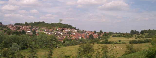
Blackpole is a small village located in the county of Worcestershire, England. Situated on the outskirts of Worcester, it is a predominantly residential area with a population of approximately 2,000 residents.

The village is known for its charming and picturesque surroundings, with lush green fields and rolling hills. It is bordered by the River Severn to the north, providing a scenic backdrop for the community. The area offers a peaceful and rural atmosphere, attracting those seeking a tranquil living environment away from the hustle and bustle of city life.

Despite its rural setting, Blackpole benefits from excellent transport links. The A449 road runs through the village, connecting it to Worcester city center and the nearby towns of Kidderminster and Wolverhampton. The M5 motorway is also easily accessible, offering convenient connections to larger cities such as Birmingham and Bristol.

Blackpole is home to a range of amenities to cater to the needs of its residents. The village has a primary school, providing education for local children, as well as a medical center and a small convenience store. For further shopping and entertainment options, residents can easily access Worcester city center, which is just a short drive away.

Overall, Blackpole offers a peaceful and idyllic setting with convenient access to nearby urban areas. It provides a close-knit community atmosphere, making it an attractive place to live for those seeking a quieter lifestyle within reach of essential amenities.

If you have any feedback on the listing, please let us know in the comments section below.

Blackpole Images

Images are sourced within 2km of 52.213714/-2.19902 or Grid Reference SO8657. Thanks to Geograph Open Source API. All images are credited.

Ronkswood An open green space in Worcester.
Ronkswood
An open green space in Worcester.
Worcester City Football Ground The Worcester and Birmingham canal passes alongside the Worcester City football ground.  On the left is the Cavalier public house.
Worcester City Football Ground
The Worcester and Birmingham canal passes alongside the Worcester City football ground. On the left is the Cavalier public house.
Cummins Farm, Hindlip Cummins Farm lies just beyond the northern edge of the city of Worcester and near Hindlip Hall, headquarters of West Mercia Constabulary.
Cummins Farm, Hindlip
Cummins Farm lies just beyond the northern edge of the city of Worcester and near Hindlip Hall, headquarters of West Mercia Constabulary.
Fernhill Heath The Bull Inn and the White Hart on the A38 as it passes through Fernhill Heath.
Fernhill Heath
The Bull Inn and the White Hart on the A38 as it passes through Fernhill Heath.
Railway at Fernhill Heath Site of the old station at Fernhill Heath on the Worcester to Droitwich line.
Railway at Fernhill Heath
Site of the old station at Fernhill Heath on the Worcester to Droitwich line.
The Mug House at Claines Attractive traditional pub near Claines church.
The Mug House at Claines
Attractive traditional pub near Claines church.
Worcester and Birmingham Canal Here the canal passes Flag Meadow, the Royal Grammar School playing field.
Worcester and Birmingham Canal
Here the canal passes Flag Meadow, the Royal Grammar School playing field.
Entrance to Worcester City Football Ground Worcester City FC play at St George's Lane.

Worcester City FC played their last game here in April 2013, since then the site has been redeveloped with housing built on the ground's former site.  As for Worcester City, they remain a homeless team, their plans for a new stadium in Worcester haven't come to fruition for various reasons.  The original plan being to build a new stadium on Nunnery Way on the east side of the city, however, this plan was shelved.  In 2017, a plan to build a stadium and sporting complex at Perdiswell was rejected by Worcester City Council.  After leaving St George's Lane, Worcester City FC played their home games at Kidderminster Harrier's Aggborough stadium for a time and now play their games at The Victoria Ground, home of Bromsgrove Sporting. Extra information added January 2019.
Entrance to Worcester City Football Ground
Worcester City FC play at St George's Lane. Worcester City FC played their last game here in April 2013, since then the site has been redeveloped with housing built on the ground's former site. As for Worcester City, they remain a homeless team, their plans for a new stadium in Worcester haven't come to fruition for various reasons. The original plan being to build a new stadium on Nunnery Way on the east side of the city, however, this plan was shelved. In 2017, a plan to build a stadium and sporting complex at Perdiswell was rejected by Worcester City Council. After leaving St George's Lane, Worcester City FC played their home games at Kidderminster Harrier's Aggborough stadium for a time and now play their games at The Victoria Ground, home of Bromsgrove Sporting. Extra information added January 2019.
Blackpole East Industrial Estate north of Blackpole
Blackpole East
Industrial Estate north of Blackpole
Worcester Bosch Factory Units north of the B4639
Worcester Bosch
Factory Units north of the B4639
Woodgreen Evangelical Church A modern church for a modern housing estate crisscrossed with roads intersecting with roundabouts in the infill between the old city and the M5.
Woodgreen Evangelical Church
A modern church for a modern housing estate crisscrossed with roads intersecting with roundabouts in the infill between the old city and the M5.
Entrance to King George's Fields The gates are dated 1937 with Worcester's coat of arms complete with the three Black Pears. The left hand pillar is inscribed "George V AD 1910-1936" and the right hand pillar "King George's Fields". It is interesting to note that there is a similar entrance located at Campsie Crescent, Omagh with plaques on either side <a href="https://www.geograph.org.uk/photo/608540">H4572 : Entrance, King George V Field, Omagh</a>.
Entrance to King George's Fields
The gates are dated 1937 with Worcester's coat of arms complete with the three Black Pears. The left hand pillar is inscribed "George V AD 1910-1936" and the right hand pillar "King George's Fields". It is interesting to note that there is a similar entrance located at Campsie Crescent, Omagh with plaques on either side H4572 : Entrance, King George V Field, Omagh.
Perdiswell Lock The Worcester to Birmingham Canal passes by the Perdiswell sports ground and golf course. this lock No 8. Looking north towards Birmingham.
Perdiswell Lock
The Worcester to Birmingham Canal passes by the Perdiswell sports ground and golf course. this lock No 8. Looking north towards Birmingham.
Court Farm,  Hindlip Part of the complex of farm buildings all currently empty.
For more on Hindlip see <span class="nowrap"><a title="http://www.users.totalise.co.uk/~fortroyal/WorcestershirePast/villages/hindlip.html" rel="nofollow ugc noopener" href="http://www.users.totalise.co.uk/~fortroyal/WorcestershirePast/villages/hindlip.html">Link</a><img style="margin-left:2px;" alt="External link" title="External link - shift click to open in new window" src="https://s1.geograph.org.uk/img/external.png" width="10" height="10"/></span>
Court Farm, Hindlip
Part of the complex of farm buildings all currently empty. For more on Hindlip see LinkExternal link
Site of Fernhill Heath Station Now all that remains is the footbridge over the Worcester to Birmingham line. A prime candidate for renewal as this village continues to expand to become a dormer town and eventually a suburb of Worcester.
Site of Fernhill Heath Station
Now all that remains is the footbridge over the Worcester to Birmingham line. A prime candidate for renewal as this village continues to expand to become a dormer town and eventually a suburb of Worcester.
The Northwick The last of Worcester's cinemas to be built, the Northwick was built in 1938 to designs by John Alexander. Behind this plain facade is an extraordinary art deco interior which has recently been restored.
The Northwick
The last of Worcester's cinemas to be built, the Northwick was built in 1938 to designs by John Alexander. Behind this plain facade is an extraordinary art deco interior which has recently been restored.
The Bull Inn, Fernhill Heath Situated on the A38 at the junction of the A4536 which provides access to the M5
The Bull Inn, Fernhill Heath
Situated on the A38 at the junction of the A4536 which provides access to the M5
Park & Ride Site, Droitwich Road, Worcester This was opened approximately two years ago to ease congestion in the centre of Worcester.  Three Express routes work from this site.
Park & Ride Site, Droitwich Road, Worcester
This was opened approximately two years ago to ease congestion in the centre of Worcester. Three Express routes work from this site.
Show me another place!

Blackpole is located at Grid Ref: SO8657 (Lat: 52.213714, Lng: -2.19902)

Administrative County: Worcestershire

District: Worcester

Police Authority: West Mercia

What 3 Words

///tape.youth.firmly. Near Fernhill Heath, Worcestershire

Nearby Locations

Blackpole

Related Wikis

RAF Worcester

Royal Air Force Worcester, or more simply RAF Worcester, is a former Royal Air Force relief landing ground (RLG) which was located 1.7 miles (2.7 km) north...

Blackpole Halt railway station

Blackpole Halt railway station was a station to the north of Worcester, Worcestershire, England. The station was opened during World War I to serve a nearby...

Astwood Halt railway station

Astwood Halt railway station was a station in Worcester, Worcestershire, England. The station was opened in 1936 and closed in 1940. == References ==

Tudor Grange Academy, Worcester

Tudor Grange Academy Worcester is a mixed secondary school in Worcester, Worcestershire, England. It occupies the site of the former Elgar Technology College...

Nearby Amenities

Located within 500m of 52.213714,-2.19902
Bus Stop
Blackpole Retail Park
Bench: no
Bin: no
Bus: yes
Lit: yes
Naptan AtcoCode: 2000G006394
Naptan Bearing: E
Naptan CommonName: Blackpole Retail Park
Naptan Indicator: East Bound
Naptan Landmark: Blackpole Retail Park
Naptan NaptanCode: wocgdwap
Naptan PlusbusZoneRef: WORCSFS
Naptan Street: Bilford Road
Naptan Verified: no
Public Transport: platform
Shelter: no
Source: naptan_import
Tactile Paving: no
Lat/Long: 52.2120685/-2.2001881
Bus Stop
Blackpole Retail Park
Bench: yes
Bin: yes
Bus: yes
Lit: yes
Naptan AtcoCode: 2000G006395
Naptan Bearing: W
Naptan CommonName: Blackpole Retail Park
Naptan Indicator: West Bound
Naptan Landmark: Elgar Retail Park
Naptan NaptanCode: wocgdwat
Naptan PlusbusZoneRef: WORCSFS
Naptan Street: Bilford Road
Naptan Verified: no
Public Transport: platform
Shelter: yes
Source: naptan_import
Tactile Paving: no
Lat/Long: 52.2119697/-2.2001438
Bus Stop
Blackpole Inn
Bench: yes
Bin: yes
Bus: yes
Naptan AtcoCode: 2000G006396
Naptan Bearing: S
Naptan CommonName: Blackpole Inn
Naptan Indicator: Adj
Naptan Landmark: Blackpole Inn
Naptan NaptanCode: wocgawdm
Naptan PlusbusZoneRef: WORCSFS
Naptan Street: Blackpole Road
Naptan Verified: no
Public Transport: platform
Shelter: yes
Source: naptan_import
Tactile Paving: no
Lat/Long: 52.2124696/-2.1985863
Bus Stop
Blackpole Inn
Bus: yes
Naptan AtcoCode: 2000G006397
Naptan Bearing: N
Naptan CommonName: Blackpole Inn
Naptan Indicator: Opp
Naptan Landmark: Blackpole Inn
Naptan NaptanCode: wocgawdp
Naptan PlusbusZoneRef: WORCSFS
Naptan Street: Blackpole Road
Naptan Verified: no
Public Transport: platform
Source: naptan_import
Lat/Long: 52.2136994/-2.1980586
Bus Stop
Elgar Retail Park
Bench: yes
Bin: yes
Bus: yes
Naptan AtcoCode: 2000G006398
Naptan Bearing: N
Naptan CommonName: Elgar Retail Park
Naptan Crossing: Masons Drive
Naptan Indicator: Adj
Naptan NaptanCode: wocgawdt
Naptan PlusbusZoneRef: WORCSFS
Naptan Street: Blackpole Road
Naptan Verified: no
Public Transport: platform
Shelter: yes
Source: naptan_import
Tactile Paving: no
Lat/Long: 52.2113061/-2.1991456
Bus Stop
Winchcombe Drive
Bus: yes
Naptan AtcoCode: 2000G007000
Naptan Bearing: NE
Naptan CommonName: Winchcombe Drive
Naptan Crossing: Winchcombe Drive
Naptan Indicator: Opp
Naptan NaptanCode: wocgatwm
Naptan PlusbusZoneRef: WORCSFS
Naptan Street: Blackpole Road
Naptan Verified: no
Public Transport: platform
Source: naptan_import
Lat/Long: 52.2152389/-2.1968067
Bus Stop
Winchcombe Drive
Bus: yes
Naptan AtcoCode: 2000G007001
Naptan Bearing: N
Naptan CommonName: Winchcombe Drive
Naptan Indicator: Adj
Naptan Landmark: Winchcombe Drive
Naptan NaptanCode: wocgatwp
Naptan PlusbusZoneRef: WORCSFS
Naptan Street: Blackpole Road
Naptan Verified: no
Public Transport: platform
Source: naptan_import
Lat/Long: 52.2153927/-2.1962219
Bus Stop
Sainsburys
Bus: yes
Naptan AtcoCode: 2000G007500
Naptan Bearing: NW
Naptan CommonName: Sainsburys
Naptan Indicator: opp
Naptan Landmark: Sainsburys
Naptan NaptanCode: wocgdtga
Naptan PlusbusZoneRef: WORCSFS
Naptan Street: Windermere Drive
Naptan Verified: no
Public Transport: platform
Source: naptan_import
Lat/Long: 52.211051/-2.1964912
Bus Stop
Sainsburys Blackpole
Bus: yes
Naptan AtcoCode: 2000G007502
Naptan Bearing: E
Naptan CommonName: Sainsburys Blackpole
Naptan Indicator: adj
Naptan Landmark: Sainsburys
Naptan NaptanCode: wocgdtgj
Naptan PlusbusZoneRef: WORCSFS
Naptan Street: Windermere Drive
Naptan Verified: no
Public Transport: platform
Source: naptan_import
Lat/Long: 52.2109285/-2.1959477
Bus Stop
Bilford Road Post Office
Bench: no
Bin: no
Bus: yes
Lit: yes
Naptan AtcoCode: 2000G123115
Naptan Bearing: NE
Naptan CommonName: Bilford Road Post Office
Naptan Indicator: opp
Naptan Landmark: Post Office
Naptan NaptanCode: wocdgjmt
Naptan PlusbusZoneRef: WORCSFS
Naptan Street: Bilford Road
Naptan Verified: no
Public Transport: platform
Shelter: no
Source: naptan_import
Tactile Paving: no
Lat/Long: 52.2118973/-2.2056611
Bus Stop
Elgar Retail Park
Bench: yes
Bin: yes
Bus: yes
Naptan AtcoCode: 2000G501891
Naptan Bearing: S
Naptan CommonName: Elgar Retail Park
Naptan Crossing: Masons DRive
Naptan Indicator: Opp
Naptan NaptanCode: wocgdjgj
Naptan PlusbusZoneRef: WORCSFS
Naptan Street: Blackpole Road
Naptan Verified: no
Public Transport: platform
Shelter: yes
Source: naptan_import
Tactile Paving: no
Lat/Long: 52.2112436/-2.1988526
Bus Stop
Cranham Trading Estate
Bus: yes
Naptan AtcoCode: 2000G501909
Naptan Bearing: E
Naptan CommonName: Cranham Trading Estate
Naptan Indicator: adj
Naptan Landmark: Cranham Trading Estate
Naptan NaptanCode: wocgjadw
Naptan PlusbusZoneRef: WORCSFS
Naptan Street: Cotswold Way
Naptan Verified: no
Public Transport: platform
Source: naptan_import
Lat/Long: 52.215955/-2.1933116
Bus Stop
Cranham Trading Estate
Bus: yes
Naptan AtcoCode: 2000G501910
Naptan Bearing: W
Naptan CommonName: Cranham Trading Estate
Naptan Indicator: Opp
Naptan Landmark: Cranham Trading Estate
Naptan NaptanCode: wocgjaga
Naptan PlusbusZoneRef: WORCSFS
Naptan Street: Cotswold Way
Naptan Verified: no
Public Transport: platform
Source: naptan_import
Lat/Long: 52.2158645/-2.1936625
Post Box
Collection Plate: CP7
Collection Times: Mo-Fr 17:30; Sa 11:30
Historic Operator: Royal Mail
Post Box Type: lamp
Ref: WR3 434
Royal Cypher: EIIR
Royal Cypher Wikidata: Q33102113
Lat/Long: 52.2119078/-2.2052154
Post Box
Post Box Type: pillar
Ref: WR4 6
Lat/Long: 52.2151391/-2.1966192
Barrier: bollard
Bicycle: yes
Bollard: fixed
Foot: yes
Lat/Long: 52.2102956/-2.202798
Barrier: bollard
Bicycle: yes
Bollard: fixed
Foot: yes
Lat/Long: 52.2102087/-2.2024196
Crossing
Lat/Long: 52.2110854/-2.194781
Crossing
Lat/Long: 52.2109486/-2.1953123
Mini Roundabout
Junction: roundabout
Lanes: 1
Lat/Long: 52.2127767/-2.1985305
Crossing
Lat/Long: 52.2111017/-2.1945567
Crossing
Lat/Long: 52.2108388/-2.1954586
Turning Circle
Lat/Long: 52.2098843/-2.2014809
Crossing
Crossing: marked
Crossing Markings: yes
Tactile Paving: yes
Lat/Long: 52.2106576/-2.2005797
Crossing
Lat/Long: 52.2110961/-2.1950498
Crossing
Lat/Long: 52.2110435/-2.1952967
Crossing
Crossing: marked
Crossing Markings: yes
Lat/Long: 52.2106393/-2.1998185
Crossing
Crossing: marked
Crossing Markings: yes
Tactile Paving: yes
Lat/Long: 52.2108598/-2.2004925
Traffic Signals
Traffic Signals Direction: forward
Lat/Long: 52.2122023/-2.2022371
Crossing
Crossing: uncontrolled
Crossing Island: no
Crossing Ref: zebra
Tactile Paving: yes
Traffic Calming: table
Lat/Long: 52.2123718/-2.2042434
Auto K
Shop: car_repair
Lat/Long: 52.2163941/-2.1940371
Blackpole Powder Coating & Shot Blasting
Industry: powder_coating
Lat/Long: 52.2148386/-2.2000262
Bodycraft 2004
Shop: car_repair
Lat/Long: 52.214092/-2.1988626
Brandon Hire Station
Brand: Brandon Hire Station
Brand Wikidata: Q111578673
Shop: tool_hire
Lat/Long: 52.2137718/-2.1987165
Collishine
Shop: car_repair
Lat/Long: 52.2149755/-2.1999597
Comcount
Industry: packaging
Lat/Long: 52.2164698/-2.1945259
Crowndell
Industry: logistics
Lat/Long: 52.2144278/-2.2002259
DNA
Industry: car_parts
Lat/Long: 52.2145647/-2.2001593
Domestic & General Insulation
Industry: insulation
Lat/Long: 52.2161255/-2.1931942
Fletcher Access
Industry: access_services
Lat/Long: 52.2143895/-2.1989954
HND Marble & Granite
Shop: building_materials
Lat/Long: 52.2140403/-2.1985761
HSS Hire
Brand: HSS Hire
Brand Wikidata: Q5636000
Brand Wikipedia: en:HSS Hire
Shop: tool_hire
Lat/Long: 52.2141505/-2.1992784
Interlink Express
Industry: logistics
Lat/Long: 52.2163269/-2.1945259
M.R. Site Services
Industry: site_services
Lat/Long: 52.2142228/-2.1996662
National Windscreens
Industry: car_parts
Lat/Long: 52.2161841/-2.1945259
Sheds Are Us
Shop: sheds
Lat/Long: 52.2142406/-2.1980097
Car Rental
SIXT
Branch: Green line Vehicle Rental
Brand: SIXT
Brand Wikidata: Q705664
Brand Wikipedia: en:Sixt
Lat/Long: 52.2139439/-2.1986154
Skyparts
Industry: car_parts
Lat/Long: 52.2143481/-2.1987332
Torque Motors
Industry: car_parts
Lat/Long: 52.2147016/-2.2000928
Vauxhall Baylis
Brand: Vauxhall
Brand Wikidata: Q59187
Brand Wikipedia: en:Vauxhall Motors
Shop: car
Lat/Long: 52.2163545/-2.1931886
WS Distributors
Fixme: What is this?
Lat/Long: 52.2162133/-2.1940371
Traffic Signals
Lat/Long: 52.2161259/-2.1958325
Entrance: main
Lat/Long: 52.2115006/-2.1993039
Crossing
Crossing: zebra
Lat/Long: 52.2114575/-2.1992336
Generator Method: photovoltaic
Generator Output Electricity: yes
Generator Source: solar
Generator Type: solar_photovoltaic_panel
Location: roof
Power: generator
Lat/Long: 52.2143616/-2.2044727
Generator Method: photovoltaic
Generator Output Electricity: yes
Generator Source: solar
Generator Type: solar_photovoltaic_panel
Location: roof
Power: generator
Lat/Long: 52.2143255/-2.204521
Generator Method: photovoltaic
Generator Output Electricity: yes
Generator Source: solar
Generator Type: solar_photovoltaic_panel
Location: roof
Power: generator
Lat/Long: 52.2146821/-2.2043762
Generator Method: photovoltaic
Generator Output Electricity: yes
Generator Source: solar
Generator Type: solar_photovoltaic_panel
Location: roof
Power: generator
Lat/Long: 52.214996/-2.2042474
Generator Method: photovoltaic
Generator Output Electricity: yes
Generator Source: solar
Generator Type: solar_photovoltaic_panel
Location: roof
Power: generator
Lat/Long: 52.2149417/-2.2013372
Generator Method: photovoltaic
Generator Output Electricity: yes
Generator Source: solar
Generator Type: solar_photovoltaic_panel
Location: roof
Power: generator
Lat/Long: 52.2149302/-2.2012433
Generator Method: photovoltaic
Generator Output Electricity: yes
Generator Source: solar
Generator Type: solar_photovoltaic_panel
Location: roof
Power: generator
Lat/Long: 52.2158234/-2.2012474
Generator Method: photovoltaic
Generator Output Electricity: yes
Generator Source: solar
Generator Type: solar_photovoltaic_panel
Location: roof
Power: generator
Lat/Long: 52.2142729/-2.1964502
Generator Method: photovoltaic
Generator Output Electricity: yes
Generator Source: solar
Generator Type: solar_photovoltaic_panel
Location: roof
Power: generator
Lat/Long: 52.2133936/-2.194275
Generator Method: photovoltaic
Generator Output Electricity: yes
Generator Source: solar
Generator Type: solar_photovoltaic_panel
Location: roof
Power: generator
Lat/Long: 52.2130912/-2.1942347
Crossing
Crossing: zebra
Crossing Island: no
Lat/Long: 52.2105336/-2.1952375
Waste: dog_excrement
Lat/Long: 52.2093087/-2.1987677
Traffic Signals
Traffic Signals Direction: backward
Lat/Long: 52.212258/-2.2013077
Traffic Signals
Traffic Signals Direction: backward
Lat/Long: 52.2121019/-2.2008759
Addr Housenumber: 2
Addr Postcode: WR4 9LH
Addr Street: Avening Close
Survey Date: 2020-06-26
Lat/Long: 52.2116929/-2.1930655
Addr Housenumber: 90
Addr Street: Randwick Drive
Survey Date: 2020-06-26
Lat/Long: 52.2116905/-2.1931383
Generator Method: photovoltaic
Generator Output Electricity: yes
Generator Source: solar
Generator Type: solar_photovoltaic_panel
Location: roof
Power: generator
Lat/Long: 52.210626/-2.1985397
Generator Method: photovoltaic
Generator Output Electricity: yes
Generator Source: solar
Generator Type: solar_photovoltaic_panel
Location: roof
Power: generator
Lat/Long: 52.210787/-2.1965119
Generator Method: photovoltaic
Generator Output Electricity: yes
Generator Source: solar
Generator Type: solar_photovoltaic_panel
Location: roof
Power: generator
Lat/Long: 52.2123813/-2.1920702
Generator Method: photovoltaic
Generator Output Electricity: yes
Generator Source: solar
Generator Type: solar_photovoltaic_panel
Location: roof
Power: generator
Lat/Long: 52.2123648/-2.1954525
Generator Method: photovoltaic
Generator Output Electricity: yes
Generator Source: solar
Generator Type: solar_photovoltaic_panel
Location: roof
Power: generator
Lat/Long: 52.2123813/-2.1955678
Generator Method: photovoltaic
Generator Output Electricity: yes
Generator Source: solar
Generator Type: solar_photovoltaic_panel
Location: roof
Power: generator
Lat/Long: 52.2123944/-2.1956912
Generator Method: photovoltaic
Generator Output Electricity: yes
Generator Source: solar
Generator Type: solar_photovoltaic_panel
Location: roof
Power: generator
Lat/Long: 52.2124585/-2.1961311
Generator Method: photovoltaic
Generator Output Electricity: yes
Generator Source: solar
Generator Type: solar_photovoltaic_panel
Location: roof
Power: generator
Lat/Long: 52.2126541/-2.1952835
Generator Method: photovoltaic
Generator Output Electricity: yes
Generator Source: solar
Generator Type: solar_photovoltaic_panel
Location: roof
Power: generator
Lat/Long: 52.2138785/-2.1941194
Generator Method: photovoltaic
Generator Output Electricity: yes
Generator Source: solar
Generator Type: solar_photovoltaic_panel
Location: roof
Power: generator
Lat/Long: 52.2143074/-2.1966165
Generator Method: photovoltaic
Generator Output Electricity: yes
Generator Source: solar
Generator Type: solar_photovoltaic_panel
Location: roof
Power: generator
Lat/Long: 52.2153838/-2.1936741
Marker: aerial
Operator: CLH
Operator Old: GPSS
Ref GPSS: 19730
Utility: oil
Lat/Long: 52.2135469/-2.1971865
Marker: pedestal
Operator: CLH
Operator Old: GPSS
Ref: MP 4093
Utility: oil
Lat/Long: 52.2114092/-2.1973993
Marker: aerial
Operator: CLH
Operator Old: GPSS
Ref: MP 4081
Utility: oil
Lat/Long: 52.2115838/-2.1973757
Marker: post
Operator: CLH
Operator Old: GPSS
Ref GPSS: 17253
Utility: oil
Lat/Long: 52.2164158/-2.2012541
Marker: post
Operator: CLH
Operator Old: GPSS
Ref GPSS: 15295
Utility: oil
Lat/Long: 52.2161513/-2.2007458
Marker: pedestal
Operator: CLH
Operator Old: GPSS
Ref: MP 2433
Utility: oil
Lat/Long: 52.2159146/-2.2004735
Marker: post
Operator: CLH
Operator Old: GPSS
Ref GPSS: 15293
Utility: oil
Lat/Long: 52.21577/-2.1998003
Marker: pedestal
Operator: CLH
Operator Old: GPSS
Ref: MP 1730
Ref GPSS: 18254
Utility: oil
Lat/Long: 52.2146583/-2.1975419
Marker: pedestal
Operator: CLH
Operator Old: GPSS
Ref: MP 1817
Utility: oil
Lat/Long: 52.2145547/-2.1973836
Marker: aerial
Operator: CLH
Operator Old: GPSS
Ref: MP 2843
Utility: oil
Lat/Long: 52.2140962/-2.1973072
Marker: pedestal
Operator: CLH
Operator Old: GPSS
Ref: MP 1959
Utility: oil
Lat/Long: 52.2118512/-2.1973394
Marker: pedestal
Operator: CLH
Operator Old: GPSS
Ref: MP 1958
Utility: oil
Lat/Long: 52.2117773/-2.1973494
Marker: pedestal
Operator: CLH
Operator Old: GPSS
Ref: MP 1801
Utility: oil
Lat/Long: 52.2115802/-2.1973761
Marker: post
Operator: CLH
Operator Old: GPSS
Ref: MP 4092
Utility: oil
Lat/Long: 52.2114111/-2.1973991
Marker: pedestal
Operator: CLH
Operator Old: GPSS
Ref: MP 1800
Utility: oil
Lat/Long: 52.2106568/-2.1956187
Marker: aerial
Operator: CLH
Operator Old: GPSS
Utility: oil
Lat/Long: 52.2162466/-2.2009289
Traffic Calming: cushion
Lat/Long: 52.2122262/-2.2025851
Crossing
Crossing: unmarked
Crossing Island: no
Crossing Markings: no
Tactile Paving: yes
Traffic Calming: table
Lat/Long: 52.2122945/-2.2033177
Traffic Calming: cushion
Lat/Long: 52.212175/-2.2048856
Traffic Calming: cushion
Lat/Long: 52.2118968/-2.2054752
Crossing
Crossing: marked
Crossing Markings: yes
Tactile Paving: yes
Lat/Long: 52.2099011/-2.2007502
Crossing
Button Operated: yes
Crossing: traffic_signals
Crossing Island: no
Tactile Paving: yes
Traffic Signals Sound: yes
Lat/Long: 52.2119448/-2.199653
Astwood Road
Power: transformer
Transformer: distribution
Voltage Primary: 11000
Lat/Long: 52.2141595/-2.2032423
Tudor Grange Academy RMU
Power: transformer
Transformer: distribution
Voltage Primary: 11000
Lat/Long: 52.2135765/-2.2041904
The data included in this document is from www.openstreetmap.org. The data is made available under ODbL.

Have you been to Blackpole?

Leave your review of Blackpole below (or comments, questions and feedback).