Rosemergy

Settlement in Cornwall

England

Rosemergy

'Wild' ponies at Bosigran The tenant at Bosigran farm has left and taken his Belted Galloway cattle with him. The National Trust have replaced them with ponies from a pony sanctuary. They roam freely, but they don't graze as efficiently as the cattle.  The fields are reverting to long grass and bracken.
'Wild' ponies at Bosigran Credit: David Medcalf

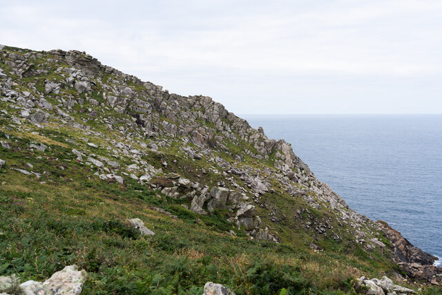
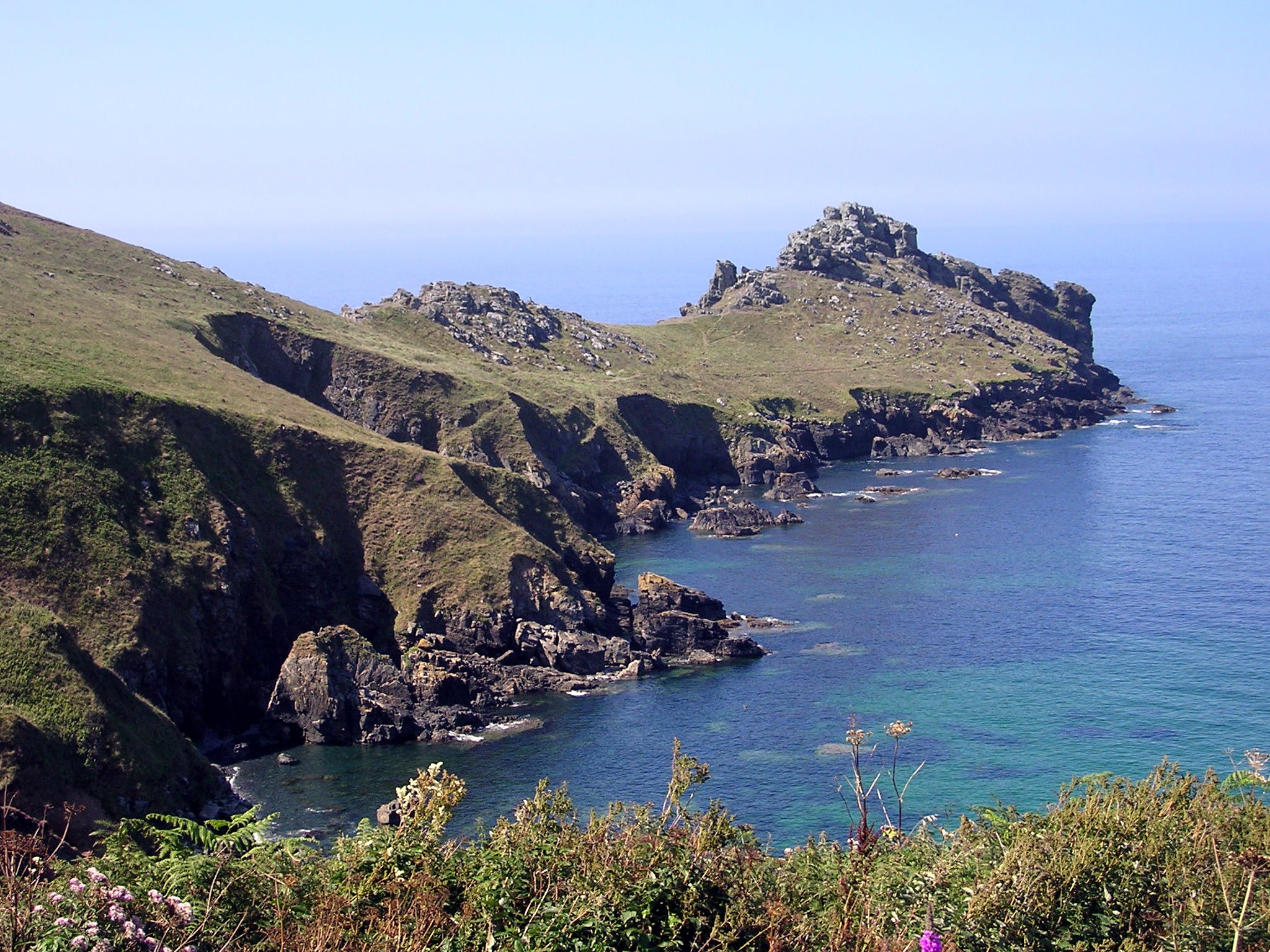
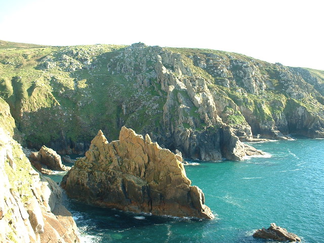
Rosemergy is a small hamlet located in the parish of St. Just in Cornwall, England. Situated on the rugged and picturesque coastline of the county, Rosemergy is known for its stunning views of the Atlantic Ocean and its proximity to popular tourist destinations such as Land's End and the Minack Theatre.

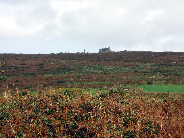
The hamlet itself is characterized by its traditional Cornish architecture, with charming stone cottages and narrow winding lanes. Rosemergy is a peaceful and secluded spot, making it an ideal destination for those seeking a quiet retreat away from the hustle and bustle of city life.

Despite its small size, Rosemergy has a rich history dating back to the 18th century, when it was a thriving mining community. Today, the hamlet is primarily residential, with a small number of farms and businesses scattered throughout the area.

Visitors to Rosemergy can enjoy leisurely walks along the coastal path, explore the nearby beaches, or visit the historic sites in the surrounding area. Whether you're looking for a relaxing getaway or a base for exploring the stunning Cornish countryside, Rosemergy offers a tranquil and picturesque setting for visitors to enjoy.

If you have any feedback on the listing, please let us know in the comments section below.

Rosemergy Images

Images are sourced within 2km of 50.170774/-5.615962 or Grid Reference SW4136. Thanks to Geograph Open Source API. All images are credited.

'Wild' ponies at Bosigran The tenant at Bosigran farm has left and taken his Belted Galloway cattle with him. The National Trust have replaced them with ponies from a pony sanctuary. They roam freely, but they don't graze as efficiently as the cattle.  The fields are reverting to long grass and bracken.
'Wild' ponies at Bosigran
The tenant at Bosigran farm has left and taken his Belted Galloway cattle with him. The National Trust have replaced them with ponies from a pony sanctuary. They roam freely, but they don't graze as efficiently as the cattle. The fields are reverting to long grass and bracken.
The buildings at Bosporthennis These are no longer completely abandoned (see: <a title="https://www.geograph.org.uk/photo/71726)," href="https://www.geograph.org.uk/photo/71726),">Link</a> but have been restored as a holiday home. So just abandoned for the majority of the year.
The buildings at Bosporthennis
These are no longer completely abandoned (see: Link but have been restored as a holiday home. So just abandoned for the majority of the year.
Path near Bosigran, with Can Galver Engine House in the distance
Porthmoina Cove
Porthmoina Cove
Porthmeor Cove from the South West Coast Path
Stone Stile SW4236a Cattle stile with granite block balanced on two blocks and one granite step each side; next to gate, probably originally a field stile. Footpath on National Trust land from B3306 to Bosigran cliff castle and SW coast path. On open land. First stile on this footpath north of the B3306 and Carn Galver 
Within farmland from the Porthmeor Stream to Porthmoina Stream.
Photo by Dr Charlotte MacKenzie
Stone Stile SW4236a
Cattle stile with granite block balanced on two blocks and one granite step each side; next to gate, probably originally a field stile. Footpath on National Trust land from B3306 to Bosigran cliff castle and SW coast path. On open land. First stile on this footpath north of the B3306 and Carn Galver Within farmland from the Porthmeor Stream to Porthmoina Stream. Photo by Dr Charlotte MacKenzie
Stone Stile SW4236a Cattle stile with granite block balanced on two blocks and one granite step each side; next to gate, probably originally a field stile. Footpath on National Trust land from B3306 to Bosigran cliff castle and SW coast path.  On open land. First stile on this footpath north of the B3306 and Carn Galver. Within farmland from the Porthmeor Stream to Porthmoina Stream.
Stone Stile SW4236a
Cattle stile with granite block balanced on two blocks and one granite step each side; next to gate, probably originally a field stile. Footpath on National Trust land from B3306 to Bosigran cliff castle and SW coast path. On open land. First stile on this footpath north of the B3306 and Carn Galver. Within farmland from the Porthmeor Stream to Porthmoina Stream.
Stone Stile SW4236b On farm land north of B3306 and west of Bosigran farm buildings, next to farm gate on track between late prehistoric and medieval field boundaries at Bosigran. On public footpath 120/15/2 Gold. Cattle stile with granite block balanced on two blocks and one granite step each side; next to gate. Looking west.
Stone Stile SW4236b
On farm land north of B3306 and west of Bosigran farm buildings, next to farm gate on track between late prehistoric and medieval field boundaries at Bosigran. On public footpath 120/15/2 Gold. Cattle stile with granite block balanced on two blocks and one granite step each side; next to gate. Looking west.
Stone Stile SW4236b On farm land north of B3306 and west of Bosigran farm buildings, next to farm gate on track between late prehistoric and medieval field boundaries at Bosigran. On public footpath 120/15/2 Gold. Cattle stile with granite block balanced on two blocks and one granite step each side; next to gate. Looking east to Bosigran farmstead
Stone Stile SW4236b
On farm land north of B3306 and west of Bosigran farm buildings, next to farm gate on track between late prehistoric and medieval field boundaries at Bosigran. On public footpath 120/15/2 Gold. Cattle stile with granite block balanced on two blocks and one granite step each side; next to gate. Looking east to Bosigran farmstead
Stone Stile SW4237a Boundary from field into Bosigran farm buildings, on Bosigran farm land north of B3306, west of Porthmeor stream. Public footpath 120/15/1 and 120/14/3 Gold. Circa early C19. Dressed granite moorstone and granite rubble. Stepped cattle stile adjoining rubble-faced hedge. Parish: Zennor
HER Number: DCO11754  Grade II listed No. 1144347
Stone Stile SW4237a
Boundary from field into Bosigran farm buildings, on Bosigran farm land north of B3306, west of Porthmeor stream. Public footpath 120/15/1 and 120/14/3 Gold. Circa early C19. Dressed granite moorstone and granite rubble. Stepped cattle stile adjoining rubble-faced hedge. Parish: Zennor HER Number: DCO11754 Grade II listed No. 1144347
Stone Stile SW4237a Boundary from field into Bosigran farm buildings, on Bosigran farm land north of B3306, west of Porthmeor stream. Public footpath 120/15/1 and 120/14/3 Gold. Dressed granite moorstone and granite rubble. Stepped cattle stile adjoining rubble-faced hedge.
Parish: Zennor
HER Number: DCO11754  Grade II listed No. 1144347
Stone Stile SW4237a
Boundary from field into Bosigran farm buildings, on Bosigran farm land north of B3306, west of Porthmeor stream. Public footpath 120/15/1 and 120/14/3 Gold. Dressed granite moorstone and granite rubble. Stepped cattle stile adjoining rubble-faced hedge. Parish: Zennor HER Number: DCO11754 Grade II listed No. 1144347
Stone Stile SW4237b Three stone steps. At eastern end of enclosed track at Bosigran/Lower Porthmeor tin working site. The stile leads south from the enclosed lane, at right angles to a second stile which is on the main path running east. Path number 120/14 gold.
Parish: Zennor
HER Number: DCO11914  Grade II listed 1137458 ‘Aqueduct and Stiles’
Stone Stile SW4237b
Three stone steps. At eastern end of enclosed track at Bosigran/Lower Porthmeor tin working site. The stile leads south from the enclosed lane, at right angles to a second stile which is on the main path running east. Path number 120/14 gold. Parish: Zennor HER Number: DCO11914 Grade II listed 1137458 ‘Aqueduct and Stiles’
Stone Stile SW4237c Cattle stile with three large steps. Public footpath 120/14/3 gold & 120/14/2 silver from: Bosigran to: Lower Porthmeor. 
Parish: Zennor
HER Number: DCO11914  Grade II listed 1137458 ‘Aqueduct and Stiles’
Stone Stile SW4237c
Cattle stile with three large steps. Public footpath 120/14/3 gold & 120/14/2 silver from: Bosigran to: Lower Porthmeor. Parish: Zennor HER Number: DCO11914 Grade II listed 1137458 ‘Aqueduct and Stiles’
Stone Stile SW4237c Cattle stile with three large steps. Public footpath 120/14/3 gold & 120/14/2 silver from Bosigran to Lower Porthmeor. 
Parish: Zennor
HER Number: DCO11914  Grade II listed 1137458 ‘Aqueduct and Stiles’
Stone Stile SW4237c
Cattle stile with three large steps. Public footpath 120/14/3 gold & 120/14/2 silver from Bosigran to Lower Porthmeor. Parish: Zennor HER Number: DCO11914 Grade II listed 1137458 ‘Aqueduct and Stiles’
Stone Stile SW4237d Cattle stile with three large steps each side. At western end of enclosed track at Bosigran/Lower Porthmeor tin working site. Public footpath 120/14/3 gold 
Parish: Zennor
HER Number: DCO11914  Grade II listed 1137458 ‘Aqueduct and Stiles’
Stone Stile SW4237d
Cattle stile with three large steps each side. At western end of enclosed track at Bosigran/Lower Porthmeor tin working site. Public footpath 120/14/3 gold Parish: Zennor HER Number: DCO11914 Grade II listed 1137458 ‘Aqueduct and Stiles’
Cliffs down to Halldrine Cove from South West Coastal Path
Footpath looking west near Captain's House in Portmeor
Show me another place!

Rosemergy is located at Grid Ref: SW4136 (Lat: 50.170774, Lng: -5.615962)

Unitary Authority: Cornwall

Police Authority: Devon and Cornwall

What 3 Words

///natively.reinvest.sounds. Near St Just, Cornwall

Related Wikis

Rosemergy

Rosemergy is a hamlet near Morvah in Cornwall, England, United Kingdom on the B3306 road between St Ives and St Just. == References ==

Aire Point to Carrick Du SSSI

Aire Point to Carrick Du SSSI is a Site of Special Scientific Interest on the Penwith Peninsula, Cornwall, England. It is 5.98 square kilometres in extent...

A. W. Andrews

Arthur Westlake Andrews (12 December 1868 – 22 November 1959) was a British geographer, poet, rock-climber, mountaineer and amateur tennis and badminton...

Watch Croft

Watch Croft (Cornish: Carnonbigh) is a prominent hill, 252 metres (827 ft) high overlooking the north coast of the Cornwall, UK. Its prominence of 225...

Related Videos

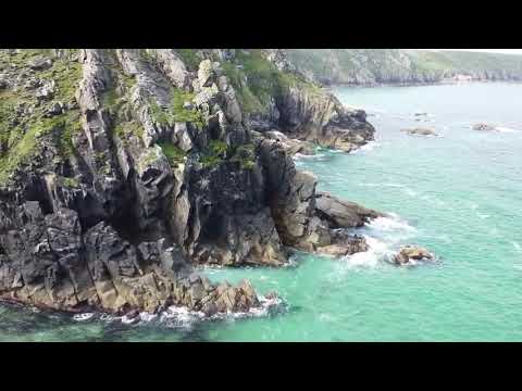
Travel & Walking Cornwall Part 10 Porthmeor Cove

Stunning cliff top walk to find Porthmeor Cove in Cornwall on a beautiful crisp and sunny September morning.

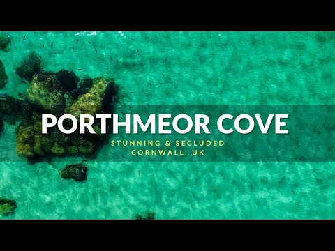
Porthmeor Cove, Relaxing, Stunning & Secluded, Cornwall, UK

Porthmeor Cove was an unexpected and very pleasant surprise. I'd heard of Porthmeor Cove but hadn't had a chance to go and ...

Climbing Commando Ridge

Great 9 pitch climb in the sunshine in Cornwall. A classic route. Drone footage courtesy of ...

The Tinners Way, West Cornwall

Scruffy & Gypsie Alan along walk the Tinners Way in West Cornwall from start to finish. From Trendrine Hill nr St Ives to Botallack ...

Nearby Amenities

Located within 500m of 50.170774,-5.615962
Source: Bing
Lat/Long: 50.1743758/-5.61986
Carn Galver Mine
Historic: yes
Tourism: attraction
Wikidata: Q97311167
Lat/Long: 50.1717389/-5.6128967
Rosemergy
Is In: Cornwall, England, UK
Place: hamlet
Wikidata: Q7368459
Wikipedia: en:Rosemergy
Lat/Long: 50.1702849/-5.6174544
Source: Bing
Lat/Long: 50.174349/-5.619951
Commando Ridge
Place: locality
Lat/Long: 50.1735695/-5.621279
Source: Bing
Lat/Long: 50.1738293/-5.6202672
Source: Bing
Lat/Long: 50.1738241/-5.6199628
Source: Bing
Lat/Long: 50.1739169/-5.6205408
Source: Bing
Lat/Long: 50.1742803/-5.6199778
Source: Bing
Lat/Long: 50.1740824/-5.6197315
Source: Bing
Lat/Long: 50.1743772/-5.6199244
Source: Bing
Lat/Long: 50.1743146/-5.6200851
Barrier: cattle_grid
Bicycle: yes
Foot: yes
Motorcar: yes
Motorcycle: yes
Lat/Long: 50.1707959/-5.613843
Cam Galver
Board Type: history
Information: board
Tourism: information
Lat/Long: 50.1718726/-5.612543
Noexit: yes
Lat/Long: 50.1742132/-5.6190562
Toilets
Lat/Long: 50.1705618/-5.6161004
Source: Bing
Lat/Long: 50.1730094/-5.6219367
Source: Bing
Lat/Long: 50.1730441/-5.6219361
Source: Bing
Lat/Long: 50.1730577/-5.621892
Great Zawn
Place: locality
Lat/Long: 50.1729558/-5.621725
Source: Bing
Lat/Long: 50.1739733/-5.6198511
Source: Bing
Lat/Long: 50.1739588/-5.6207008
Source: Bing
Lat/Long: 50.174458/-5.6198606
Source: Bing
Lat/Long: 50.1741592/-5.6196975
Source: Bing
Lat/Long: 50.1740401/-5.6196766
Source: Bing
Lat/Long: 50.1742588/-5.6196899
Source: Bing
Lat/Long: 50.1740061/-5.6197032
Source: Bing
Lat/Long: 50.1739448/-5.6197601
Source: Bing
Lat/Long: 50.1741719/-5.6202048
Source: Bing
Lat/Long: 50.1741531/-5.6202702
Source: Bing
Lat/Long: 50.174124/-5.6202608
Source: Bing
Lat/Long: 50.1740274/-5.62
Barrier: stile
Lat/Long: 50.1734041/-5.6160314
Barrier: stile
Lat/Long: 50.1728261/-5.6150813
Source: Bing
Lat/Long: 50.1739812/-5.6199478
Source: Bing
Lat/Long: 50.1741288/-5.6197838
Source: Bing
Lat/Long: 50.174144/-5.619889
Source: Bing
Lat/Long: 50.1742308/-5.6201289
Source: Bing
Lat/Long: 50.1741683/-5.6197288
Source: Bing
Lat/Long: 50.1742485/-5.6198729
Source: Bing
Lat/Long: 50.1742703/-5.6200597
Source: Bing
Lat/Long: 50.1742655/-5.6201119
Source: Bing
Lat/Long: 50.1740286/-5.6198966
Source: Bing
Lat/Long: 50.1740735/-5.6199744
Source: Bing
Lat/Long: 50.1740037/-5.6199554
Source: Bing
Lat/Long: 50.1739454/-5.6199232
Source: Bing
Lat/Long: 50.1738986/-5.6199715
Source: Bing
Lat/Long: 50.1737683/-5.6201559
Source: Bing
Lat/Long: 50.1739066/-5.6206508
Cafe
Rosemergy Tea Rooms
Cuisine: cream_tea
Lat/Long: 50.1704931/-5.6166382
Heritage: yes
Historic: archaeological_site
Wikidata: Q26612664
Lat/Long: 50.1703643/-5.6165859
Barrier: stile
Lat/Long: 50.1728261/-5.6150813
Barrier: stile
Lat/Long: 50.1728261/-5.6150813
Ford: yes
Lat/Long: 50.1726954/-5.6156808
Rosemergy
Power: substation
Voltage: 11000
Lat/Long: 50.1706763/-5.6174503
Power: substation
Voltage: 11000
Lat/Long: 50.1726049/-5.6125887
The data included in this document is from www.openstreetmap.org. The data is made available under ODbL.

Have you been to Rosemergy?

Leave your review of Rosemergy below (or comments, questions and feedback).