Bishop's Cleeve

Settlement in Gloucestershire Tewkesbury

England

Bishop's Cleeve

Bishop's Cleeve Church - St Michael's & All Angels
Bishop's Cleeve Church - St Michael's & All Angels Credit: William J Bagshaw

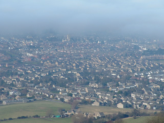
Bishop's Cleeve is a charming village located in the Tewkesbury borough of Gloucestershire, England. Situated at the foot of the picturesque Cotswold Hills, it lies approximately three miles northeast of Cheltenham. With a population of around 10,000 residents, it offers a peaceful and close-knit community atmosphere.

The village is steeped in history, with evidence of human habitation dating back to the Iron Age. Its name derives from the Old English word "cleof" meaning "cliff," referring to the nearby hills. The area has seen various influences over the years, including Roman occupation and medieval settlements.

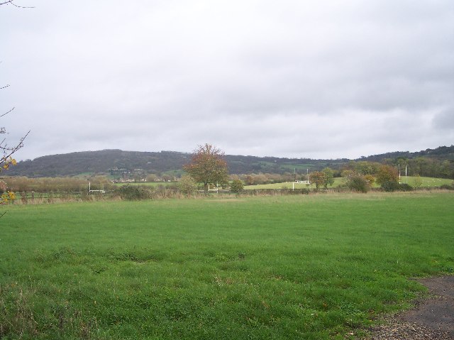
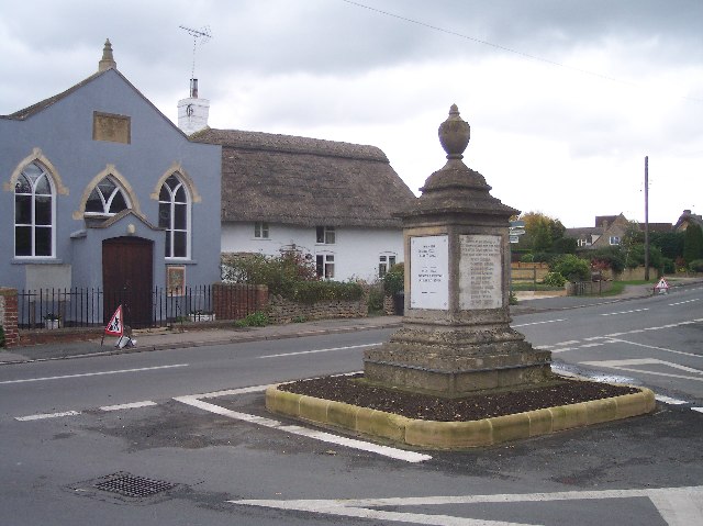
Bishop's Cleeve offers a range of amenities and services to its residents. The village's high street is home to an array of independent shops, supermarkets, pubs, and restaurants, catering to the needs of locals and visitors alike. The nearby Cleeve Hill provides stunning views of the surrounding countryside, and its expansive open spaces are ideal for outdoor activities such as walking, hiking, and horse riding.

Education is well-served in Bishop's Cleeve, with several primary schools, secondary schools, and a sixth form college within easy reach. The village also benefits from excellent transport links, with regular bus services connecting it to nearby towns and cities. The nearby M5 motorway provides convenient access for commuters, with Cheltenham and Gloucester just a short drive away.

Overall, Bishop's Cleeve offers a delightful blend of historical charm, natural beauty, and modern amenities. Its idyllic location, strong community spirit, and range of facilities make it a desirable place to live, visit, and explore.

If you have any feedback on the listing, please let us know in the comments section below.

Bishop's Cleeve Images

Images are sourced within 2km of 51.947048/-2.058951 or Grid Reference SO9627. Thanks to Geograph Open Source API. All images are credited.

Bishop's Cleeve Church - St Michael's & All Angels
Rugby Pitches, Bishop's Cleeve Looking north east with Nottingham Hill in the background.
Rugby Pitches, Bishop's Cleeve
Looking north east with Nottingham Hill in the background.
Tithe Barn Village Hall, Bishop's Cleeve In the centre of this ever expanding village opposite Cleeve Hall.
Tithe Barn Village Hall, Bishop's Cleeve
In the centre of this ever expanding village opposite Cleeve Hall.
Bishop's Cleeve Business Park Off the road from Bishop's Cleeve to Stoke Orchard.
Bishop's Cleeve Business Park
Off the road from Bishop's Cleeve to Stoke Orchard.
West End of Gotherington Village Once just a scattering of farm buildings and the pub some way from the village this area is now a fully populated linear extension along the road out to Treddington.
West End of Gotherington Village
Once just a scattering of farm buildings and the pub some way from the village this area is now a fully populated linear extension along the road out to Treddington.
Gotherington War Memorial In the centre of the village close to the Post Office. The date on the church and sabbath school is 1833
Gotherington War Memorial
In the centre of the village close to the Post Office. The date on the church and sabbath school is 1833
Gloucestershire & Warwickshire Railway Embankment Looking south eastover the fields to the stretch of the railway between Bishop's Cleeve and Gotherington. In the distance is Cleeve Hill.
Gloucestershire & Warwickshire Railway Embankment
Looking south eastover the fields to the stretch of the railway between Bishop's Cleeve and Gotherington. In the distance is Cleeve Hill.
Nortenham Allotments, Bishop's Cleeve On the outside of the new by-pass close to Dean Farm. The original allotment site is ready for infill development.
Nortenham Allotments, Bishop's Cleeve
On the outside of the new by-pass close to Dean Farm. The original allotment site is ready for infill development.
Foothills of the Cotswolds, Woodmancote Looking east with Cleeve Hill in the background.
Foothills of the Cotswolds, Woodmancote
Looking east with Cleeve Hill in the background.
Kings Farm, Woodmancote One of the older buildings in what is now a crowded urban environment.
Kings Farm, Woodmancote
One of the older buildings in what is now a crowded urban environment.
"The Nurseries", bishop's Cleeve Modern infill between the old village centre and the by-pass. Bishop's Cleeve must have increased its size tenfold in a few decades with many estates similar to this one.
"The Nurseries", bishop's Cleeve
Modern infill between the old village centre and the by-pass. Bishop's Cleeve must have increased its size tenfold in a few decades with many estates similar to this one.
A Field Full of Sheep, Bishop's Cleeve Looking west north west over rough pasture land very close to one of the many housing estates in this ever expanding "village". How soon before all this is under tarmac, lawns and double glazing? A wonderful view of the complete range of the Malvern Hills.
A Field Full of Sheep, Bishop's Cleeve
Looking west north west over rough pasture land very close to one of the many housing estates in this ever expanding "village". How soon before all this is under tarmac, lawns and double glazing? A wonderful view of the complete range of the Malvern Hills.
Bushcomb Wood, Nottingham Hill On the side of Nottingham Hill just below the Iron Age Hill Fort
Bushcomb Wood, Nottingham Hill
On the side of Nottingham Hill just below the Iron Age Hill Fort
Gotherington With (from L-R) the war memorial, Gotherington Free Church and Woodbine Cottage.
Gotherington
With (from L-R) the war memorial, Gotherington Free Church and Woodbine Cottage.
Bushcomb Wood Footpath through Bushcomb Wood on Nottingham Hill.
Bushcomb Wood
Footpath through Bushcomb Wood on Nottingham Hill.
St. Michael & All Angel's Church, Bishop's Cleeve
Leisure garden in centre of Bishop's Cleeve
Gotherington Lane, Bishop's Cleeve Looking south to the start of the village with the church tower in the background
Gotherington Lane, Bishop's Cleeve
Looking south to the start of the village with the church tower in the background
Show me another place!

Bishop's Cleeve is located at Grid Ref: SO9627 (Lat: 51.947048, Lng: -2.058951)

Administrative County: Gloucestershire

District: Tewkesbury

Police Authority: Gloucestershire

What 3 Words

///wipe.hype.note. Near Bishops Cleeve, Gloucestershire

Nearby Locations

Bishop's Cleeve

Related Wikis

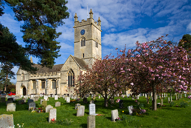
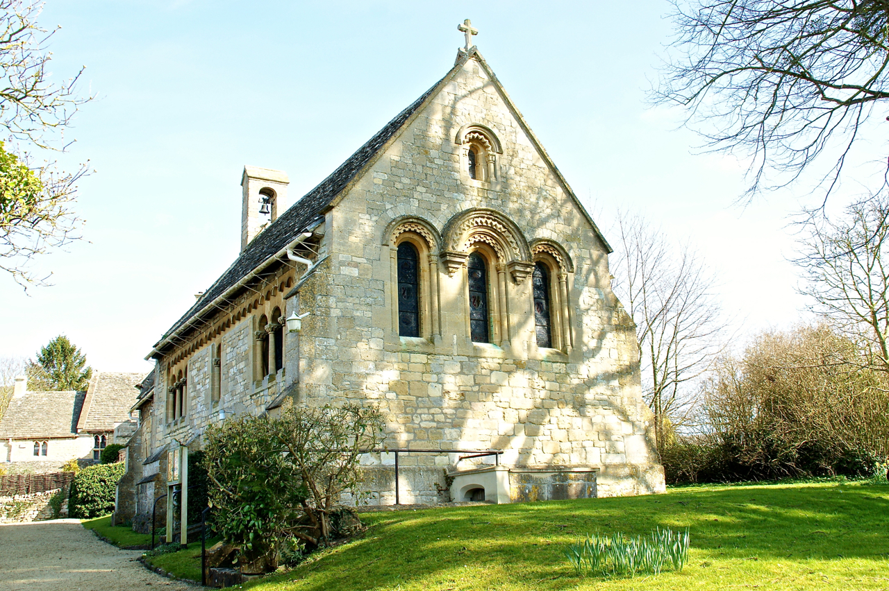
St Michael & All Angels Church, Bishop's Cleeve

St Michael & All Angels is the Anglican church in the village of Bishop's Cleeve, just north of Cheltenham in Gloucestershire. Informally the church is...

Bishop's Cleeve

Bishop's Cleeve is a large village and civil parish in the Borough of Tewkesbury in the ceremonial county of Gloucestershire, England. The village lies...

Bishops Cleeve railway station

Bishop's Cleeve railway station was a railway station that served the village of Bishop's Cleeve in Gloucestershire, England. It was opened by the Great...

Cleeve School

Cleeve School is an academy school and Leadership Partner School. It was formerly a comprehensive school and is located in the village of Bishop's Cleeve...

Bishop's Cleeve F.C.

Bishop's Cleeve Football Club is a semi-professional football club based in Bishop's Cleeve, near Cheltenham, Gloucestershire, England. They are currently...

Woodmancote, Tewkesbury Borough

Woodmancote is a village and civil parish in Gloucestershire, England. The parish lies immediately east of Bishop's Cleeve; the village is about 3+1⁄2...

Gotherington

Gotherington is a small village north of Bishops Cleeve in Gloucestershire, England. It is surrounded on the north by the villages of Woolstone and Oxenton...

Southam, Gloucestershire

Southam is a village in Gloucestershire, England, located on the outskirts of Cheltenham. Its main features are a Manor House, which has now been converted...

Nearby Amenities

Located within 500m of 51.947048,-2.058951
Mini Roundabout
Direction: clockwise
Lat/Long: 51.9466104/-2.0639323
Traffic Signals
Crossing: traffic_signals
Crossing Ref: pelican
Lat/Long: 51.9472522/-2.0632143
Crossing
Crossing: marked
Lat/Long: 51.9478351/-2.0622855
Mini Roundabout
Direction: clockwise
Lat/Long: 51.9487004/-2.0617266
Crossing
Crossing: marked
Lat/Long: 51.947359/-2.0608958
Mini Roundabout
Direction: clockwise
Lat/Long: 51.9475247/-2.0623171
Post Box
Brand: Royal Mail
Brand Wikidata: Q638098
Operator: Royal Mail
Operator Wikidata: Q638098
Post Box Type: lamp
Postal Code: GL52
Ref: GL52 330
Lat/Long: 51.94466/-2.0531842
Post Box
Brand: Royal Mail
Brand Wikidata: Q638098
Operator: Royal Mail
Operator Wikidata: Q638098
Postal Code: GL52
Ref: GL52 305
Lat/Long: 51.9431065/-2.0587132
Post Box
Brand: Royal Mail
Brand Wikidata: Q638098
Operator: Royal Mail
Operator Wikidata: Q638098
Postal Code: GL52
Ref: GL52 146
Lat/Long: 51.9507172/-2.061565
Recycling
Recycling Glass: yes
Lat/Long: 51.9503628/-2.0554267
Barrier: bollard
Lat/Long: 51.9442853/-2.0640772
Crossing
Crossing: marked
Source: Bing
Lat/Long: 51.9466759/-2.0603803
Historic: memorial
Lat/Long: 51.9472038/-2.0587033
Pub
The Swallow
Addr City: Cheltenham
Addr Postcode: GL52 8DR
Addr Street: Bishops Drive
Addr Village: Bishops Cleeve
Fhrs Id: 31866
Source Addr: FHRS Open Data
Lat/Long: 51.9443968/-2.0604254
Place Of Worship
Bishops Cleeve Methodist Church
Denomination: methodist
Religion: christian
Lat/Long: 51.9445409/-2.0578469
Post Box
Bishops Cleeve Post Office
Brand: Royal Mail
Brand Wikidata: Q638098
Operator: Royal Mail
Operator Wikidata: Q638098
Ref: GL52 329
Lat/Long: 51.9472506/-2.059592
Post Office
Bishop's Cleve Post Office
Addr City: Cheltenham
Addr Housenumber: 37
Addr Postcode: GL52 8LP
Addr Street: Church Road
Addr Town: Bishop's Cleve
Brand: Post Office
Brand Wikidata: Q1783168
Fhrs Id: 27399
Opening Hours: Mo-Fr 07:30-17:00; Sa 07:30-13:00
Operator: Post Office
Operator Wikidata: Q1783168
Ref Pol Id: 13029
Source Addr: FHRS Open Data
Website: https://www.postoffice.co.uk/branch-finder/3305236/bishops-cleeve
Lat/Long: 51.94733/-2.0595764
Bus Stop
Cleevecroft Ave
Bus: yes
Naptan AtcoCode: 1600GL3765
Naptan Bearing: NW
Naptan CommonName: Cleevecroft Ave
Naptan NaptanCode: glodtwjm
Naptan PlusbusZoneRef: CHLTNHM
Naptan Street: Pecked Lane
Naptan Verified: no
Public Transport: platform
Source: naptan_import
Lat/Long: 51.945512/-2.0561731
Bus Stop
Cleevecroft Ave
Bus: yes
Naptan AtcoCode: 1600GL3766
Naptan Bearing: SE
Naptan CommonName: Cleevecroft Ave
Naptan Indicator: Opp
Naptan NaptanCode: glodtwmj
Naptan PlusbusZoneRef: CHLTNHM
Naptan Street: Pecked Lane
Naptan Verified: no
Public Transport: platform
Source: naptan_import
Lat/Long: 51.9453594/-2.0556928
Bus Stop
Hardy Road
Bench: no
Bin: no
Bus: yes
Lit: yes
Naptan AtcoCode: 1600GL423
Naptan Bearing: N
Naptan CommonName: Hardy Road
Naptan Indicator: corner of
Naptan NaptanCode: glodtwgj
Naptan PlusbusZoneRef: CHLTNHM
Naptan Street: Gotherington Lane
Naptan Verified: no
Public Transport: platform
Shelter: no
Source: naptan_import
Tactile Paving: no
Lat/Long: 51.9501871/-2.0566591
Bus Stop
Hardy Rd
Bench: yes
Bin: yes
Bus: yes
Naptan AtcoCode: 1600GL424
Naptan Bearing: S
Naptan CommonName: Hardy Rd
Naptan Indicator: Opp
Naptan NaptanCode: glodtwgt
Naptan PlusbusZoneRef: CHLTNHM
Naptan Street: Gotherington Ln
Naptan Verified: no
Public Transport: platform
Shelter: no
Source: naptan_import
Tactile Paving: no
Lat/Long: 51.9504147/-2.0564686
Bus Stop
War Memorial
Bus: yes
Naptan AtcoCode: 1600GL425
Naptan Bearing: NW
Naptan CommonName: War Memorial
Naptan Indicator: Opp
Naptan NaptanCode: glodtpwg
Naptan PlusbusZoneRef: CHLTNHM
Naptan Street: Pecked Lane
Naptan Verified: no
Public Transport: platform
Source: naptan_import
Lat/Long: 51.9469316/-2.0582118
Bus Stop
War Memorial
Bench: yes
Bin: no
Bus: yes
Naptan AtcoCode: 1600GL426
Naptan Bearing: SE
Naptan CommonName: War Memorial
Naptan NaptanCode: glodtpwd
Naptan PlusbusZoneRef: CHLTNHM
Naptan Street: Pecked Lane
Naptan Verified: no
Public Transport: platform
Shelter: yes
Source: naptan_import
Tactile Paving: no
Lat/Long: 51.9470125/-2.0581828
Bus Stop
Mill Parade
Bench: no
Bin: no
Bus: yes
Naptan AtcoCode: 1600GL427
Naptan Bearing: NW
Naptan CommonName: Mill Parade
Naptan NaptanCode: glodtpdj
Naptan PlusbusZoneRef: CHLTNHM
Naptan Street: Church Rd
Naptan Verified: no
Public Transport: platform
Shelter: no
Source: naptan_import
Tactile Paving: no
Lat/Long: 51.9473973/-2.0617916
Bus Stop
Mill Parade
Bus: yes
Naptan AtcoCode: 1600GL428
Naptan Bearing: SE
Naptan CommonName: Mill Parade
Naptan Indicator: opp
Naptan NaptanCode: glodtpdg
Naptan PlusbusZoneRef: CHLTNHM
Naptan Street: Church Road
Naptan Verified: no
Public Transport: platform
Source: naptan_import
Lat/Long: 51.9474245/-2.0611343
Bus Stop
St Michael & All Angels Church
Bus: yes
Naptan AtcoCode: 1600GL429
Naptan Bearing: SW
Naptan CommonName: St Michael & All Angels Church
Naptan Indicator: Opp
Naptan NaptanCode: glodtpwt
Naptan PlusbusZoneRef: CHLTNHM
Naptan Street: School Rd
Naptan Verified: no
Public Transport: platform
Source: naptan_import
Lat/Long: 51.9479567/-2.0578785
Bus Stop
Tobyfield Close
Bus: yes
Naptan AtcoCode: 1600GL431
Naptan Bearing: N
Naptan CommonName: Tobyfield Close
Naptan NaptanCode: glodtptg
Naptan PlusbusZoneRef: CHLTNHM
Naptan Street: Tobyfield Rd
Naptan Verified: no
Public Transport: platform
Source: naptan_import
Lat/Long: 51.9453487/-2.0591118
Bus Stop
Tobyfield Close
Bus: yes
Naptan AtcoCode: 1600GL432
Naptan Bearing: S
Naptan CommonName: Tobyfield Close
Naptan NaptanCode: glodtptj
Naptan PlusbusZoneRef: CHLTNHM
Naptan Street: Tobyfield Rd
Naptan Verified: no
Public Transport: platform
Source: naptan_import
Lat/Long: 51.9454926/-2.0589956
Bus Stop
The Swallow
Bus: yes
Naptan AtcoCode: 1600GL455
Naptan Bearing: E
Naptan CommonName: The Swallow
Naptan NaptanCode: glodtpja
Naptan PlusbusZoneRef: CHLTNHM
Naptan Street: Bishops Drive
Naptan Verified: no
Public Transport: platform
Source: naptan_import
Lat/Long: 51.9442602/-2.0603033
Bus Stop
The Swallow
Bus: yes
Naptan AtcoCode: 1600GL456
Naptan Bearing: W
Naptan CommonName: The Swallow
Naptan NaptanCode: glodtpmd
Naptan PlusbusZoneRef: CHLTNHM
Naptan Street: Bishops Drive
Naptan Verified: no
Public Transport: platform
Source: naptan_import
Lat/Long: 51.9442245/-2.0598814
Bus Stop
Gilders Paddock
Bus: yes
Naptan AtcoCode: 1600GL5517
Naptan Bearing: NE
Naptan CommonName: Gilders Paddock
Naptan Indicator: Opp
Naptan NaptanCode: glodtpat
Naptan PlusbusZoneRef: CHLTNHM
Naptan Street: Cheltenham Rd
Naptan Verified: no
Public Transport: platform
Source: naptan_import
Lat/Long: 51.9482963/-2.0620838
Bus Stop
Gilders Paddock
Bus: yes
Naptan AtcoCode: 1600GL5518
Naptan Bearing: SW
Naptan CommonName: Gilders Paddock
Naptan Indicator: nr
Naptan NaptanCode: glodtpda
Naptan PlusbusZoneRef: CHLTNHM
Naptan Street: Cheltenham Road
Naptan Verified: no
Public Transport: platform
Source: naptan_import
Lat/Long: 51.9483413/-2.0619238
Bus Stop
Woodmans Way
Bus: yes
Naptan AtcoCode: 1600GLA311
Naptan Bearing: N
Naptan CommonName: Two Hedges Rd
Naptan NaptanCode: glodtmwm
Naptan PlusbusZoneRef: CHLTNHM
Naptan Street: Bishops Drive
Naptan Verified: no
Public Transport: platform
Source: naptan_import
Lat/Long: 51.9436924/-2.062863
Bus Stop
Woodmans Way
Bus: yes
Naptan AtcoCode: 1600GLA312
Naptan Bearing: S
Naptan CommonName: Two Hedges Rd
Naptan NaptanCode: glodtmwp
Naptan PlusbusZoneRef: CHLTNHM
Naptan Street: Bishops Drive
Naptan Verified: no
Public Transport: platform
Source: naptan_import
Lat/Long: 51.9435396/-2.0627901
Bus Stop
Shipway Court
Bench: no
Bin: no
Bus: yes
Lit: yes
Naptan AtcoCode: 1600GLA36665
Naptan Bearing: E
Naptan CommonName: Shipway Court
Naptan NaptanCode: glogmgwt
Naptan PlusbusZoneRef: CHLTNHM
Naptan Street: Station Rd
Public Transport: platform
Shelter: yes
Source: naptan_import;survey
Tactile Paving: no
Lat/Long: 51.9489022/-2.0603858
Bus Stop
Shipway Court
Bus: yes
Naptan AtcoCode: 1600GLA36666
Naptan Bearing: W
Naptan CommonName: Shipway Court
Naptan Indicator: Opp
Naptan NaptanCode: glogmjad
Naptan PlusbusZoneRef: CHLTNHM
Naptan Street: Station Rd
Naptan Verified: no
Public Transport: platform
Source: naptan_import
Lat/Long: 51.9487319/-2.0608793
Bus Stop
Lidl Store
Bus: yes
Naptan AtcoCode: 1600GLA605
Naptan Bearing: E
Naptan CommonName: Lidl Store
Naptan Indicator: opp
Naptan NaptanCode: glodtmwg
Naptan PlusbusZoneRef: CHLTNHM
Naptan Street: Evesham Road
Public Transport: platform
Shelter: yes
Source: naptan_import;yes
Lat/Long: 51.948884/-2.0626442
Bus Stop
Lidl Store
Bus: yes
Naptan AtcoCode: 1600GLA606
Naptan Bearing: W
Naptan CommonName: Lidl Store
Naptan NaptanCode: glodtmtw
Naptan PlusbusZoneRef: CHLTNHM
Naptan Street: Evesham Rd
Public Transport: platform
Shelter: no
Source: naptan_import;survey
Lat/Long: 51.9487997/-2.0631458
Bus Stop
Churchfields
Bus: yes
Naptan AtcoCode: 1600GLA607
Naptan Bearing: SE
Naptan CommonName: Churchfields
Naptan NaptanCode: glodtwag
Naptan PlusbusZoneRef: CHLTNHM
Naptan Street: Pecked Lane
Naptan Verified: no
Public Transport: platform
Source: naptan_import
Lat/Long: 51.9467341/-2.0576732
Bus Stop
Millham Rd
Bench: no
Bin: no
Bus: yes
Naptan AtcoCode: 1600GLA774
Naptan Bearing: E
Naptan CommonName: Millham Rd
Naptan NaptanCode: glodwatp
Naptan PlusbusZoneRef: CHLTNHM
Naptan Street: Station Rd
Naptan Verified: no
Public Transport: platform
Shelter: no
Source: naptan_import
Tactile Paving: no
Lat/Long: 51.9484538/-2.0524084
Bus Stop
Tesco Superstore Forecourt
Bus: yes
Naptan AtcoCode: 1600GLA796
Naptan Bearing: W
Naptan CommonName: Tesco Superstore Forecourt
Naptan NaptanCode: glodtpdm
Naptan PlusbusZoneRef: CHLTNHM
Naptan Street: Off Church Rd
Naptan Verified: no
Public Transport: platform
Source: naptan_import
Lat/Long: 51.9467174/-2.0615326
Atm
RBS
Brand: RBS
Brand Wikidata: Q160126
Official Name: Royal Bank of Scotland
Operator: RBS
Operator Wikidata: Q160126
Lat/Long: 51.9466947/-2.0613477
Atm
RBS
Brand: RBS
Brand Wikidata: Q160126
Official Name: Royal Bank of Scotland
Operator: RBS
Operator Wikidata: Q160126
Lat/Long: 51.946698/-2.061431
Post Box
Note: Inside Tesco store. May be a private box run by Tesco, rather than one collected by Royal Mail
Lat/Long: 51.9466512/-2.0619558
Bishop's Cleeve
Alt Name: Bishop's Cleeve
Is In: Gloucestershire, England, UK
Place: town
Wikidata: Q4917406
Wikipedia: cy:Bishop's Cleeve
Lat/Long: 51.9468176/-2.0564818
Co-op Food
Addr City: Cheltenham
Addr Housenumber: 3-5
Addr Postcode: GL52 8DH
Addr Street: The Green
Brand: Co-op Food
Brand Wikidata: Q3277439
Brand Wikipedia: en:Co-op Food
Fhrs Id: 134584
Opening Hours: Mo-Su 07:00-22:00
Operator: Midcounties Co-operative
Operator Wikidata: Q6841138
Shop: convenience
Wheelchair: yes
Lat/Long: 51.9446785/-2.0597544
Disused Amenity: bank
Lat/Long: 51.9446818/-2.0595238
NatWest
Brand: NatWest
Brand Wikidata: Q2740021
Brand Wikipedia: en:NatWest
Disused Amenity: bank
Note: Building remains, but is unused. All bank signs and features (e.g. ATM) removed.
Lat/Long: 51.9474164/-2.0596632
Addr City: Cheltenham
Addr Housenumber: 38
Addr Postcode: GL52 8LR
Addr Street: Church Road
Disused Amenity: bank
Old Name: TSB
Lat/Long: 51.9470339/-2.0593441
Atm
Fixme: Probably not still there as bank closed
Lat/Long: 51.9470494/-2.0593682
Cat's Whiskers
Addr Postcode: GL52 8RL
Shop: gift
Website: https://www.catswhiskersuk.com/
Lat/Long: 51.947228/-2.061117
Kindergarten
Cleeve Playgroup
Lat/Long: 51.945039/-2.0601407
A. R. Hill & Sons
Shop: butcher
Lat/Long: 51.944685/-2.059969
Fast Food
Cleeve Fish Bar
Addr City: Cheltenham
Addr Housenumber: 1
Addr Postcode: GL52 8LR
Addr Street: Church Road
Addr Village: Bishops Cleeve
Cuisine: fish_and_chips
Fhrs Id: 27393
Opening Hours: Mo-Th,Sa 11:30-14:00, Mo-Th 16:30-21:30; Fr 11:30-14:00,16:30-22:00
Source Addr: FHRS Open Data
Wheelchair: no
Lat/Long: 51.9477039/-2.0621309
Note: Was removed when the bank closed
Removed Amenity: atm
Lat/Long: 51.9473644/-2.0597496
Fast Food
Pan Pizza
Addr City: Cheltenham
Addr Housenumber: 17
Addr Postcode: GL52 8LR
Addr Street: Church Road
Addr Village: Bishops Cleeve
Cuisine: pizza
Fhrs Id: 428803
Source Addr: FHRS Open Data
Lat/Long: 51.9475421/-2.0616052
Townhall
Cleeve Council
Lat/Long: 51.9471122/-2.0604518
Disused Amenity: atm
Lat/Long: 51.944685/-2.0594594
Barrier: bollard
Lat/Long: 51.9446155/-2.0591268
Barrier: bollard
Lat/Long: 51.9444866/-2.0591107
Barrier: bollard
Lat/Long: 51.9444173/-2.0591107
Lowry's
Addr City: Cheltenham
Addr Housenumber: 3
Addr Parentstreet: Church Road
Addr Postcode: GL52 8RN
Addr Street: Tarlings Yard
Addr Village: Bishops Cleeve
Fhrs Id: 666975
Shop: bakery
Source Addr: FHRS Open Data
Lat/Long: 51.9477658/-2.0604149
Eden of Cleeve
Shop: florist
Lat/Long: 51.9475322/-2.0610955
Charity Shop
Shop: clothes
Lat/Long: 51.9474495/-2.0604679
Laundry
Shop: laundry
Lat/Long: 51.9473072/-2.0590034
Pub
The Kings Head
Addr City: Cheltenham
Addr Housenumber: 19
Addr Postcode: GL52 8LU
Addr Street: Cheltenham Road
Addr Village: Bishop's Cleeve
Fhrs Id: 505487
Wikidata: Q26446792
Lat/Long: 51.9473568/-2.06256
Cleeve outdoors
Shop: clothes
Lat/Long: 51.9472349/-2.0591434
Barrier: bollard
Lat/Long: 51.9459351/-2.0590249
ak hair
Shop: hairdresser
Lat/Long: 51.9476743/-2.0618948
Pharmacy
Badham Pharmacy
Addr Housenumber: 23
Addr Postcode: GL52 8LR
Addr Street: Church Road
Healthcare: pharmacy
Lat/Long: 51.9474659/-2.0610794
Cleeve hardware and garden supplies
Shop: doityourself
Lat/Long: 51.9468051/-2.0592829
Joyce Arnold
Addr City: Cheltenham
Addr Housenumber: 38A
Addr Postcode: GL52 8LP
Addr Street: Church Road
Addr Village: Bishops Cleeve
Fhrs Id: 27400
Shop: greengrocer
Source Addr: FHRS Open Data
Lat/Long: 51.9470162/-2.0592682
Barrier: bollard
Lat/Long: 51.9459351/-2.0590973
Barrier: bollard
Lat/Long: 51.9445527/-2.0591268
Danny's cafe and bakery
Addr City: Cheltenham
Addr Housenumber: 21
Addr Postcode: GL52 8LR
Addr Street: Church Road
Addr Village: Bishops Cleeve
Fhrs Id: 716339
Shop: bakery
Source Addr: FHRS Open Data
Lat/Long: 51.947509/-2.0613745
Community building
Leisure: sports_centre
Lat/Long: 51.946421/-2.0604197
Bus Stop
St Michael & All Angels Church
Bus: yes
Naptan AtcoCode: 1600GL430
Naptan Bearing: NE
Naptan CommonName: St Michael & All Angels Church
Naptan Indicator: o/s
Naptan NaptanCode: glodtpwp
Naptan PlusbusZoneRef: CHLTNHM
Naptan Street: School Road
Naptan Verified: no
Public Transport: platform
Source: naptan_import
Lat/Long: 51.9481362/-2.0578906
Crossing
Crossing: marked
Source: Bing
Lat/Long: 51.9470962/-2.0619959
Crossing
Crossing: marked
Source: Bing
Lat/Long: 51.9470495/-2.0611126
Crossing
Crossing: marked
Source: Bing
Lat/Long: 51.9470758/-2.0601005
Crossing
Crossing: marked
Source: Bing
Lat/Long: 51.9471714/-2.0620515
Crossing
Crossing: marked
Source: Bing
Lat/Long: 51.9466911/-2.0607074
Cafe
Costa
Addr City: Cheltenham
Addr Postcode: GL52 8LR
Addr Street: Church Road
Addr Village: Bishop's Cleeve
Brand: Costa
Brand Wikidata: Q608845
Brand Wikipedia: en:Costa Coffee
Cuisine: coffee_shop
Fhrs Id: 27404
Not Addr Postcode: GL52 4LR
Note: Inferred from previous tagging of supermarkey polygon. Exact posisiont in store unknown.
Source Addr: FHRS Open Data
Takeaway: yes
Lat/Long: 51.9466366/-2.062021
Crossing
Crossing: marked
Source: Bing
Lat/Long: 51.9467757/-2.061168
Check Date: 2022-05-21
Traffic Calming: choker
Lat/Long: 51.9459368/-2.0590654
Entrance: yes
Lat/Long: 51.9465748/-2.0632547
Manor Cottage B&B
Addr City: Cheltenham
Addr Housenumber: 41
Addr Postcode: GL52 8HH
Addr Street: Station Road
Fhrs Id: 27471
Tourism: guest_house
Url: http://www.manorcottagebishopscleeve.co.uk/
Lat/Long: 51.9491354/-2.0580524
Leisure: picnic_table
Lat/Long: 51.9446383/-2.0552131
Fast Food
Subway
Addr City: Cheltenham
Addr Housenumber: 4
Addr Parentstreet: Church Road
Addr Postcode: GL52 8RL
Addr Street: Mill Parade
Addr Unit: Unit A
Addr Village: Bishops Cleeve
Brand: Subway
Brand Wikidata: Q244457
Brand Wikipedia: en:Subway (restaurant)
Contact Website: https://restaurants.subway.com/united-kingdom/en/bishops-cleeve-cheltenham/unit-a-rear-of-4-mill-parade-church-road
Cuisine: sandwich
Fhrs Id: 984825
Source Addr: FHRS Open Data
Takeaway: yes
Lat/Long: 51.9471793/-2.0616927
George Lewis Footwear
Addr City: Cheltenham
Addr Postcode: GL52 8LP
Addr Street: Church Road
Opening Hours: Mo-Sa 09:00-17:00
Shop: shoes
Website: https://www.glfootwear.co.uk/
Lat/Long: 51.9471978/-2.0592118
Dentist
Greyholme Dental Suite
Addr Postcode: GL52 8LT
Addr Street: Church Road
Healthcare: dentist
Phone: +441242673448
Lat/Long: 51.947454/-2.0608424
Defibrillator
Access: emergency
Defibrillator Location: Locked box by steps
Emergency: defibrillator
Indoor: no
Lat/Long: 51.94743/-2.0608196
Defibrillator
Description: Located behind the Customer Services Desk
Emergency: defibrillator
Indoor: yes
Lat/Long: 51.946638/-2.0619608
Addr City: Cheltenham
Addr Postcode: GL52 8DJ
Lat/Long: 51.9446874/-2.0598048
Direction: 215
Generator Method: photovoltaic
Generator Output Electricity: yes
Generator Solar Modules: 9
Generator Source: solar
Generator Type: solar_photovoltaic_panel
Location: roof
Power: generator
Lat/Long: 51.9509904/-2.0589213
Direction: 185
Generator Method: photovoltaic
Generator Output Electricity: yes
Generator Solar Modules: 16
Generator Source: solar
Generator Type: solar_photovoltaic_panel
Location: roof
Power: generator
Lat/Long: 51.9505608/-2.0580905
Generator Method: photovoltaic
Generator Output Electricity: yes
Generator Solar Modules: 16
Generator Source: solar
Generator Type: solar_photovoltaic_panel
Location: roof
Power: generator
Lat/Long: 51.9498794/-2.057654
Generator Method: photovoltaic
Generator Output Electricity: yes
Generator Solar Modules: 20
Generator Source: solar
Generator Type: solar_photovoltaic_panel
Location: roof
Power: generator
Lat/Long: 51.94945/-2.0577452
Generator Method: photovoltaic
Generator Output Electricity: yes
Generator Source: solar
Generator Type: solar_photovoltaic_panel
Location: roof
Power: generator
Lat/Long: 51.9469764/-2.0654807
Generator Method: photovoltaic
Generator Output Electricity: yes
Generator Source: solar
Generator Type: solar_photovoltaic_panel
Location: roof
Power: generator
Lat/Long: 51.9469458/-2.0654136
Generator Method: photovoltaic
Generator Output Electricity: yes
Generator Source: solar
Generator Type: solar_photovoltaic_panel
Location: roof
Power: generator
Lat/Long: 51.948218/-2.0643085
Generator Method: photovoltaic
Generator Output Electricity: yes
Generator Source: solar
Generator Type: solar_photovoltaic_panel
Location: roof
Power: generator
Lat/Long: 51.947922/-2.0643112
Generator Method: photovoltaic
Generator Output Electricity: yes
Generator Source: solar
Generator Type: solar_photovoltaic_panel
Location: roof
Power: generator
Lat/Long: 51.9482262/-2.0648557
Kindergarten
Cleeve Day Nursery
Addr City: Cheltenham
Addr Housenumber: 2
Addr Postcode: GL52 8NF
Addr Street: Cheltenham Road
Lat/Long: 51.9486412/-2.0619361
Fast Food
Sing's Kitchen
Addr Postcode: GL52 8LR
Addr Street: Church Road
Cuisine: chinese
Lat/Long: 51.9476889/-2.0620541
The Village Clinic
Addr City: Cheltenham
Addr Housenumber: 11
Addr Parentstreet: Church Road
Addr Postcode: GL52 8RN
Addr Street: Tarlings Yard
Healthcare: physiotherapist;podiatrist
Website: https://www.villageclinic.co.uk/
Lat/Long: 51.9476662/-2.0603103
Macdonald Cobblers
Shop: shoe_repair
Lat/Long: 51.947658/-2.0606059
SJ Beauty
Shop: beauty
Lat/Long: 51.9477568/-2.0603316
UK People Finder
Office: yes
Lat/Long: 51.9477204/-2.0605873
Billy Sheers
Addr Housenumber: 6
Addr Parentstreet: Church Road
Addr Street: Tarlings Yard
Shop: hairdresser
Lat/Long: 51.9477824/-2.0605544
Parking
Lat/Long: 51.9477527/-2.060866
Post Box
Brand: Royal Mail
Brand Wikidata: Q638098
Operator: Royal Mail
Operator Wikidata: Q638098
Post Box Mounting: pier
Post Box Type: lamp
Ref: GL52 191
Lat/Long: 51.9488226/-2.0545656
Telephone
Booth: K6
Covered: booth
Operator: BT
Operator Wikidata: Q593786
Phone: +44 1424 672021
Lat/Long: 51.9474111/-2.062112
Neu Kithens
Addr Street: Church Road
Addr Substreet: Mill Parade
Addr Unit: A
Shop: kitchen
Lat/Long: 51.9470975/-2.0611784
Bar
Bar no. 9
Lat/Long: 51.9476249/-2.0618275
Pet Grooming
Shop: pet_grooming
Lat/Long: 51.9473443/-2.0617082
Veterinary
Folly Gardens Veterinary Clinic
Addr City: Cheltenham
Addr Housenumber: 2
Addr Postcode: GL52 8LR
Addr Street: Church Road
Not Addr Postcode: GL52 8RL
Lat/Long: 51.9473377/-2.0617721
Andrews
Addr Street: Church Road
Addr Substreet: Mill Parade
Office: estate_agent
Lat/Long: 51.9473383/-2.0615783
Guildford and Carter
Addr Postcode: GL52 8LR
Addr Street: Church Road
Note: In two parts either side of Badhams
Shop: optician
Website: https://www.guilfordandcarter.com/
Lat/Long: 51.947459/-2.0611676
Bishops Cleeve Barber Shop
Addr Housenumber: 21A
Addr Street: Church Road
Shop: hairdresser
Lat/Long: 51.9474625/-2.0612818
Longfield
Addr Street: Church Road
Addr Substreet: Mill Parade
Addr Unit: 5-6
Shop: charity
Website: https://www.longfield.org.uk/store/bishops-cleeve/
Lat/Long: 51.9472417/-2.0612964
Ladbrokes
Brand: Ladbrokes
Brand Wikidata: Q1799875
Shop: bookmaker
Lat/Long: 51.9472317/-2.061196
Guildford and Carter
Addr Housenumber: 23a
Addr Street: Church Road
Note: In two parts either side of Badhams
Shop: optician
Website: https://www.guilfordandcarter.com/
Lat/Long: 51.9474605/-2.0610176
Bus Stop
Newdawn Close School stop
Bus: yes
Naptan AtcoCode: 160000592
Naptan Bearing: N
Naptan CommonName: Newdawn Close School stop
Naptan Indicator: opp
Naptan NaptanCode: glojadwm
Naptan Verified: no
Public Transport: platform
Lat/Long: 51.9452232/-2.0641429
Bus Stop
Newdawn Close School stop
Bus: yes
Naptan AtcoCode: 160000593
Naptan Bearing: S
Naptan CommonName: Newdawn Close School stop
Naptan Indicator: nr
Naptan NaptanCode: glojadwp
Naptan Verified: no
Public Transport: platform
Lat/Long: 51.9449549/-2.0640386
Entrance: main
Lat/Long: 51.9480223/-2.0626317
The data included in this document is from www.openstreetmap.org. The data is made available under ODbL.

Have you been to Bishop's Cleeve?

Leave your review of Bishop's Cleeve below (or comments, questions and feedback).