Birtsmorton

Settlement in Worcestershire Malvern Hills

England

Birtsmorton

Rye Street Well-kept council cottages in a small cul-de-sac to the left.
A nice willow in the front garden.
Rye Street Credit: Jonathan Billinger

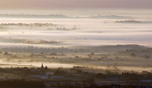
Birtsmorton is a picturesque village located in the county of Worcestershire, England. It is situated approximately 6 miles south-east of the city of Malvern and 10 miles south-west of the historic town of Tewkesbury. Birtsmorton is nestled within a rural setting, surrounded by rolling countryside, charming farmland, and the Malvern Hills in the distance.

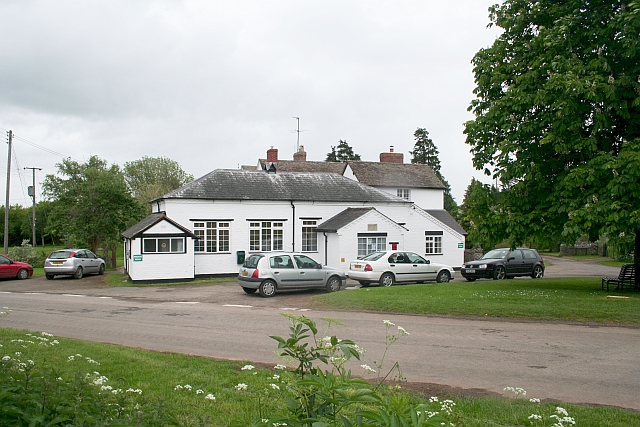
The village itself is small and intimate, with a population of around 500 residents. It is renowned for its quaint and well-preserved medieval architecture, with many of its buildings dating back several centuries. One of the most notable landmarks is Birtsmorton Court, a stunning moated manor house that dates back to the 14th century. The manor house is surrounded by beautiful gardens, including a historic moat, which is a popular attraction for visitors.

Birtsmorton offers a peaceful and tranquil atmosphere, making it a desirable place to live and visit. The community is tight-knit and friendly, with a strong sense of community spirit. The village also benefits from a local church, a primary school, and a village hall, which serves as a hub for various community activities and events.

For nature enthusiasts, Birtsmorton is an ideal location, with an abundance of walking paths and cycling routes in the surrounding countryside. The nearby Malvern Hills offer breathtaking views and opportunities for outdoor activities such as hiking, rock climbing, and paragliding.

Overall, Birtsmorton is a charming and idyllic village, offering a peaceful retreat from the hustle and bustle of city life. Its rich history, stunning surroundings, and welcoming community make it a hidden gem in Worcestershire.

If you have any feedback on the listing, please let us know in the comments section below.

Birtsmorton Images

Images are sourced within 2km of 52.017939/-2.290699 or Grid Reference SO8035. Thanks to Geograph Open Source API. All images are credited.

Rye Street Well-kept council cottages in a small cul-de-sac to the left.
A nice willow in the front garden.
Rye Street
Well-kept council cottages in a small cul-de-sac to the left. A nice willow in the front garden.
Smallholding in Rye Street Well a few ducks and two ponies in a field with a public path heading north to Birtsmorton.
The Malvern Hills discernible in the distance.
Smallholding in Rye Street
Well a few ducks and two ponies in a field with a public path heading north to Birtsmorton. The Malvern Hills discernible in the distance.
St. Faith's church, Berrow A scattered country parish in South Worcestershire.
The first rays of the day's sunlight are catching the east window.
St. Faith's church, Berrow
A scattered country parish in South Worcestershire. The first rays of the day's sunlight are catching the east window.
Village hall and tree The epicentre of the scattered parish of Berrow.
Village hall and tree
The epicentre of the scattered parish of Berrow.
Rape crop and a view to the Malvern Hills Pre-sunrise shot from Berrow.
Rape crop and a view to the Malvern Hills
Pre-sunrise shot from Berrow.
Track and footpath Leading from Berrow church towards Underhill Farm.
Sun is rising over to the left.
Track and footpath
Leading from Berrow church towards Underhill Farm. Sun is rising over to the left.
Footpath around a rape-field Heading towards Birts Street; Malvern Hills in the distance.
Footpath around a rape-field
Heading towards Birts Street; Malvern Hills in the distance.
Footpath into pasture This public path joins a network of rights-of-way between Birts Street and Rye Street.
Footpath into pasture
This public path joins a network of rights-of-way between Birts Street and Rye Street.
Miller's Court Road Miller's Court and its farm are to the right.
Ragged Stone Hill can be seen between the trees.
Miller's Court Road
Miller's Court and its farm are to the right. Ragged Stone Hill can be seen between the trees.
Red rambling rose Gracing the outer wall of buildings at Miller's Court; also seen in <a href="https://www.geograph.org.uk/photo/3107366">SO7936 : Miller's Court Road</a>.
Red rambling rose
Gracing the outer wall of buildings at Miller's Court; also seen in SO7936 : Miller's Court Road.
Footpath into maize A claustrophobic walk from Miller's Court Road to Castlemorton.
Footpath into maize
A claustrophobic walk from Miller's Court Road to Castlemorton.
Miller's Court Road Looking west towards Birts Street.
Miller's Court Road
Looking west towards Birts Street.
Castlemorton church and November mist Taken from Black Hill on the Malverns just after dawn.
Castlemorton church and November mist
Taken from Black Hill on the Malverns just after dawn.
Castlemorton church with mist over Longdon Marsh Viewed from Black Hill on the Malverns.  Mist follows the route of the River Severn and a large patch smothers the low land of Longdon Marsh.
Castlemorton church with mist over Longdon Marsh
Viewed from Black Hill on the Malverns. Mist follows the route of the River Severn and a large patch smothers the low land of Longdon Marsh.
Approaching Castlemorton Entering this straggling Worcestershire village from the east.
Approaching Castlemorton
Entering this straggling Worcestershire village from the east.
Castlemorton's old farm buildings, 1 Part of Castle Farm.
Castlemorton's old farm buildings, 1
Part of Castle Farm.
Castlemorton's old farm buildings, 2 Unusual brick and iron building by the main village street.
Castlemorton's old farm buildings, 2
Unusual brick and iron building by the main village street.
Castlemorton's cottages and houses, 1 Victorian house opposite the church.
Castlemorton's cottages and houses, 1
Victorian house opposite the church.
Show me another place!

Birtsmorton is located at Grid Ref: SO8035 (Lat: 52.017939, Lng: -2.290699)

Administrative County: Worcestershire

District: Malvern Hills

Police Authority: West Mercia

What 3 Words

///abundance.prospered.pine. Near Corse, Gloucestershire

Related Wikis

Birtsmorton

Birtsmorton is a village and civil parish in the Malvern Hills of Worcestershire, England, which at the 2021 census had a population of 257. It is in...

Birtsmorton Court

Birtsmorton Court is a Grade I listed fortified medieval moated manor house near Malvern in Worcestershire, in the former woodlands of Malvern Chase. It...

Berrow, Worcestershire

Berrow is a village and civil parish in the Malvern Hills district of Worcestershire, England, about seven miles east of Ledbury. According to the 2021...

RAF Berrow

Royal Air Force Berrow or more simply RAF Berrow is a former Royal Air Force Satellite Landing Ground located near Berrow, Worcestershire, England. �...

Nearby Amenities

Located within 500m of 52.017939,-2.290699
Birtsmorton
Place: village
Wikidata: Q2257219
Wikipedia: en:Birtsmorton
Lat/Long: 52.0169687/-2.2896506
Birtsmorton Court
Naptan AtcoCode: 2000G057700
Naptan Bearing: S
Naptan BusStopType: CUS
Naptan CommonName: Birtsmorton Court
Naptan Indicator: Adj
Naptan Landmark: Village Road
Naptan NaptanCode: wocdjgdm
Naptan Street: Village Road
Naptan Verified: no
Source: naptan_import
Lat/Long: 52.0177607/-2.290382
Post Box
Collection Plate: none
Fixme: Need to get PB, Court, road all GPS correct.
Fixme2: Need to visit to see if it's been nicked
Historic Operator: Post Office
Post Box Type: wall
Ref: WR13 108
Royal Cypher: VR
Royal Cypher Wikidata: Q33102356
Lat/Long: 52.018025/-2.290861
Power: pole
Lat/Long: 52.0211405/-2.2856444
Power: pole
Lat/Long: 52.0211845/-2.287295
Power: pole
Lat/Long: 52.0208952/-2.2885811
Power: pole
Lat/Long: 52.020613/-2.289845
Power: pole
Lat/Long: 52.0211977/-2.2913136
Power: pole
Lat/Long: 52.0213792/-2.2927211
Power: pole
Lat/Long: 52.021555/-2.2941306
Power: pole
Lat/Long: 52.0209169/-2.2904187
Power: pole
Lat/Long: 52.0209994/-2.2905783
Brake Lodge
Power: pole
Transformer: distribution
Voltage Primary: 11000
Lat/Long: 52.0152289/-2.290636
Power: pole
Lat/Long: 52.0160421/-2.2907755
Power: pole
Lat/Long: 52.0166975/-2.2899909
Power: pole
Lat/Long: 52.0172649/-2.2899534
Power: pole
Lat/Long: 52.0178216/-2.2899044
Power: pole
Lat/Long: 52.0183944/-2.2904452
Birtsmorton Court
Power: pole
Transformer: distribution
Voltage Primary: 11000
Lat/Long: 52.0189783/-2.2910008
Power: pole
Lat/Long: 52.0193352/-2.2910699
Power: pole
Lat/Long: 52.0200268/-2.2912093
Power: pole
Lat/Long: 52.0196794/-2.2911369
Power: pole
Lat/Long: 52.0203268/-2.2911168
Power: pole
Lat/Long: 52.0212854/-2.2867991
The data included in this document is from www.openstreetmap.org. The data is made available under ODbL.

Have you been to Birtsmorton?

Leave your review of Birtsmorton below (or comments, questions and feedback).