Birchfield

Settlement in Staffordshire

England

Birchfield

Tame Valley Canal goes under the M6 road
Tame Valley Canal goes under the M6 road Credit: Ian S

Birchfield is a small village located in the county of Staffordshire, England. Situated approximately 4 miles south of the town of Uttoxeter, Birchfield is surrounded by picturesque countryside and offers a quiet and serene living environment.

The village is known for its quaint and charming character, with a mix of traditional stone cottages and more modern houses. Birchfield is home to a close-knit community and offers a range of amenities for its residents. These include a local pub, a village hall, and a small convenience store, ensuring that basic needs are met without the need for extensive travel.

The village is well-connected to nearby towns and cities, with good transport links available. The A50 road runs close to Birchfield, providing easy access to Uttoxeter, Stoke-on-Trent, and Derby. Additionally, the village is served by several bus routes, allowing for convenient travel to surrounding areas.

Nature lovers will appreciate Birchfield's proximity to beautiful countryside and outdoor recreational opportunities. The nearby Peak District National Park offers stunning landscapes and a variety of activities such as hiking, cycling, and wildlife spotting. The village itself is surrounded by fields and farmland, providing a peaceful setting for outdoor walks and exploration.

Overall, Birchfield is a charming village in Staffordshire that offers a tranquil living environment, a close-knit community, and easy access to both rural and urban amenities.

If you have any feedback on the listing, please let us know in the comments section below.

Birchfield Images

Images are sourced within 2km of 52.509255/-1.892998 or Grid Reference SP0790. Thanks to Geograph Open Source API. All images are credited.

Tame Valley Canal goes under the M6 road
Tame Valley Canal towards Witton Turnover Bridge
Memorial to D. C. Michael Swindells On the Tame Valley Canal towpath.
Memorial to D. C. Michael Swindells
On the Tame Valley Canal towpath.
Memorial to D. C. Michael Swindells
Tame Valley Canal at Slip Road Bridge
Tame Valley Canal at Witton Turnover Bridge
Witton Turnover Bridge over the Tame Valley Canal
Tame Valley Canal at Witton Turnover Bridge
Tame Valley Canal towards Perry Barr Bottom Lock
Tame Valley Canal towards Perry Barr Bottom Lock Perry Bar Lock #13
Tame Valley Canal towards Perry Barr Bottom Lock
Perry Bar Lock #13
Tame Valley Canal at Perry Barr Bottom Lock, Lock #13
Tame Valley Canal towards Deykin Avenue Bridge
Tame Valley Canal at Deykin Avenue Bridge
Tame Valley Canal at Perry Barr Lock #12
Lockkeepers' cottages, Tame Valley Canal at Perry Barr Lock #12
Show me another place!

Birchfield is located at Grid Ref: SP0790 (Lat: 52.509255, Lng: -1.892998)

Unitary Authority: Birmingham

Police Authority: West Midlands

What 3 Words

///calls.joke.mops. Near Aston, West Midlands

Nearby Locations

Birchfield

Related Wikis

All Souls' Church, Witton

All Souls' Church is a former parish church in the Church of England in Witton, Birmingham, England which is now used by the Church of God. == History... ==
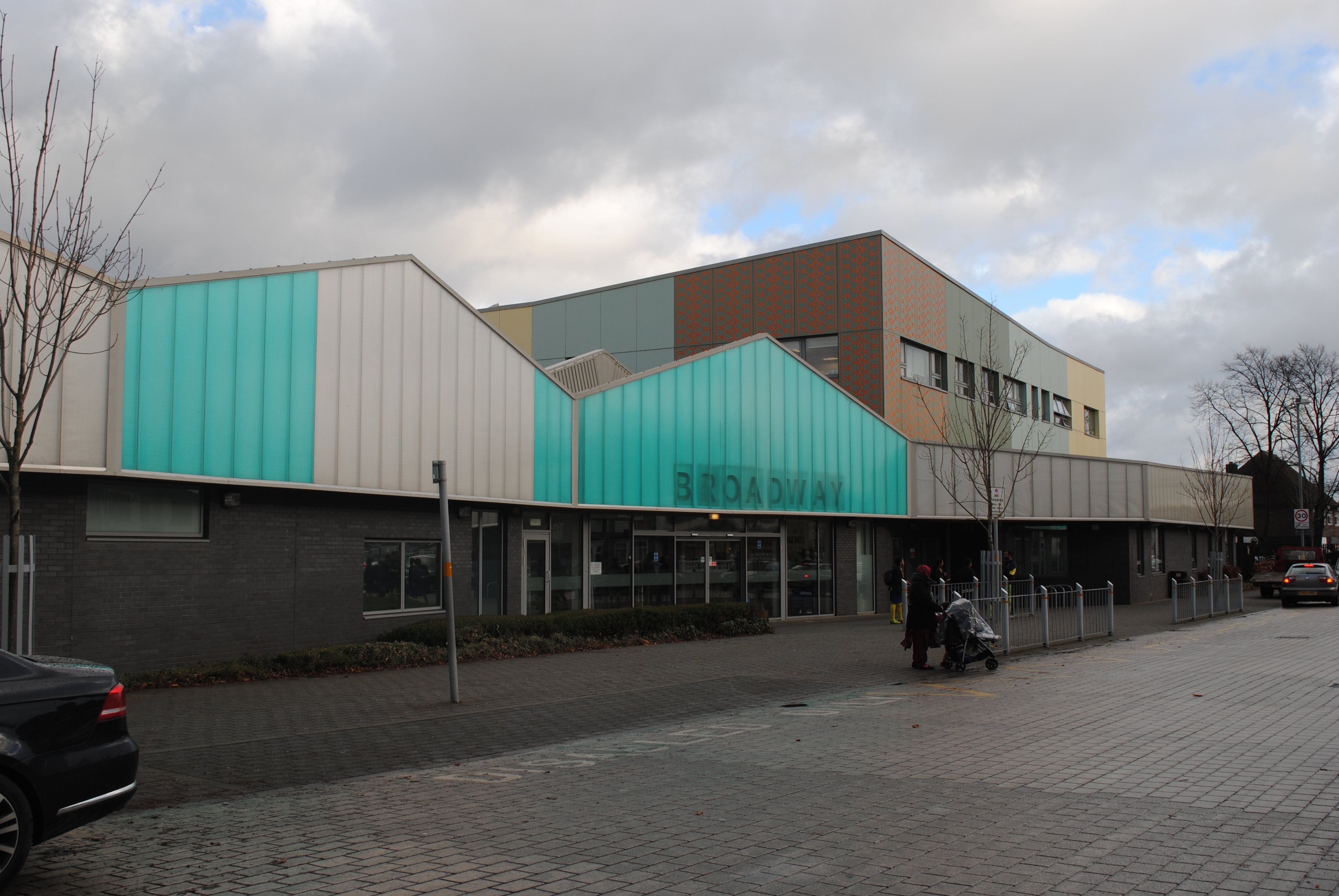
Broadway Academy

Broadway Academy (formerly Broadway School) is a coeducational secondary school and sixth form with academy status, located in the Perry Barr area of Birmingham...
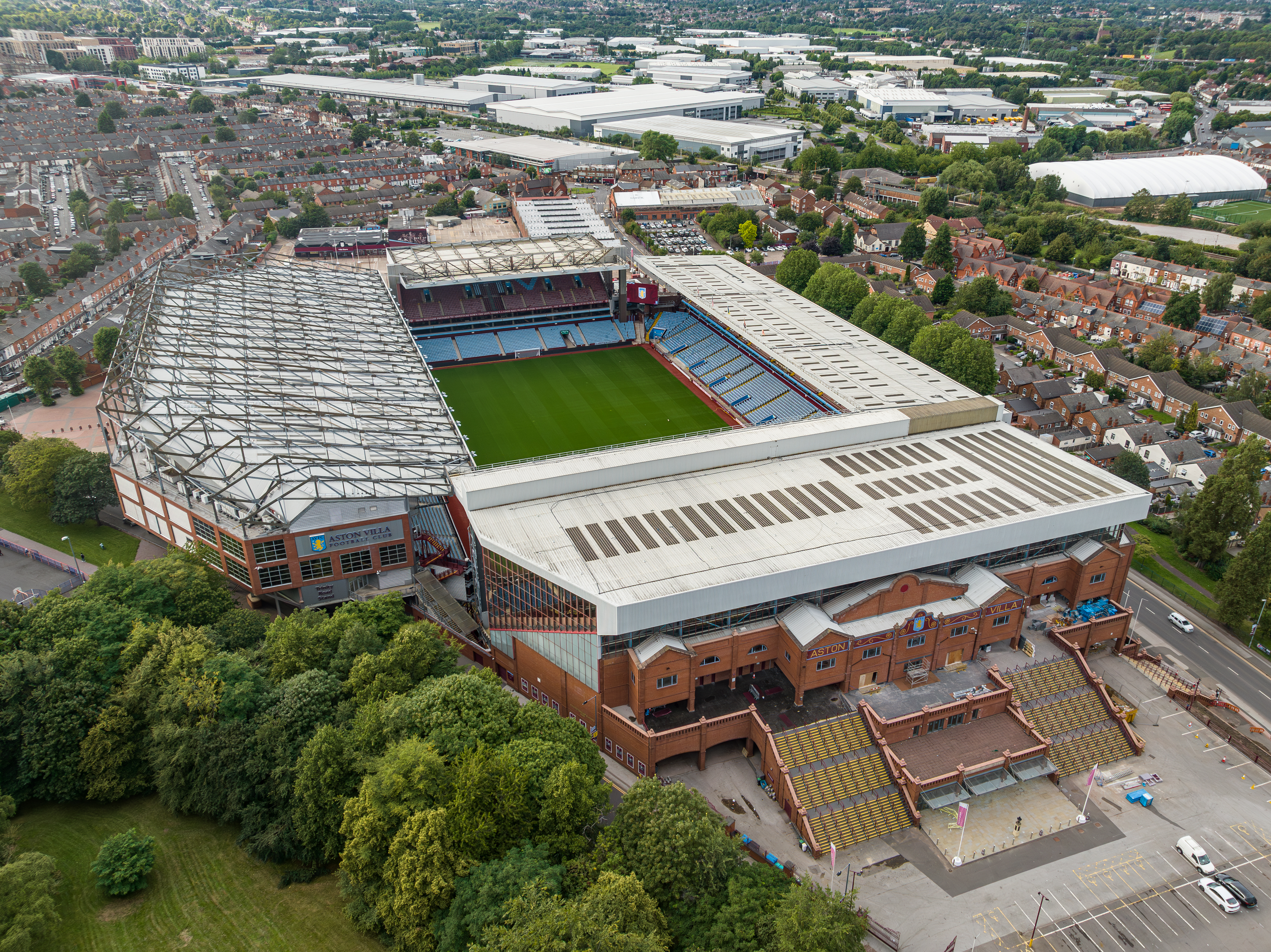
Villa Park

Villa Park is a football stadium in Aston, Birmingham, with a seating capacity of 42,657. It has been the home of Premier League club Aston Villa since...

List of EFL Championship stadiums

Since the inception of the EFL Championship, England's current second tier, in 2004, there have been 61 stadiums used in the League. Following the Hillsborough...

St James' Church, Aston

St James' Church is a parish church in the Church of England in Aston, Birmingham, England. == History == The church formed as a mission church from Church...
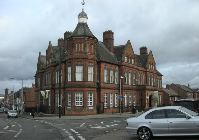
Aston Library

Aston Library is a public library in Aston, West Midlands, England, built in 1881. It is a Grade II listed building. == History and description == The...

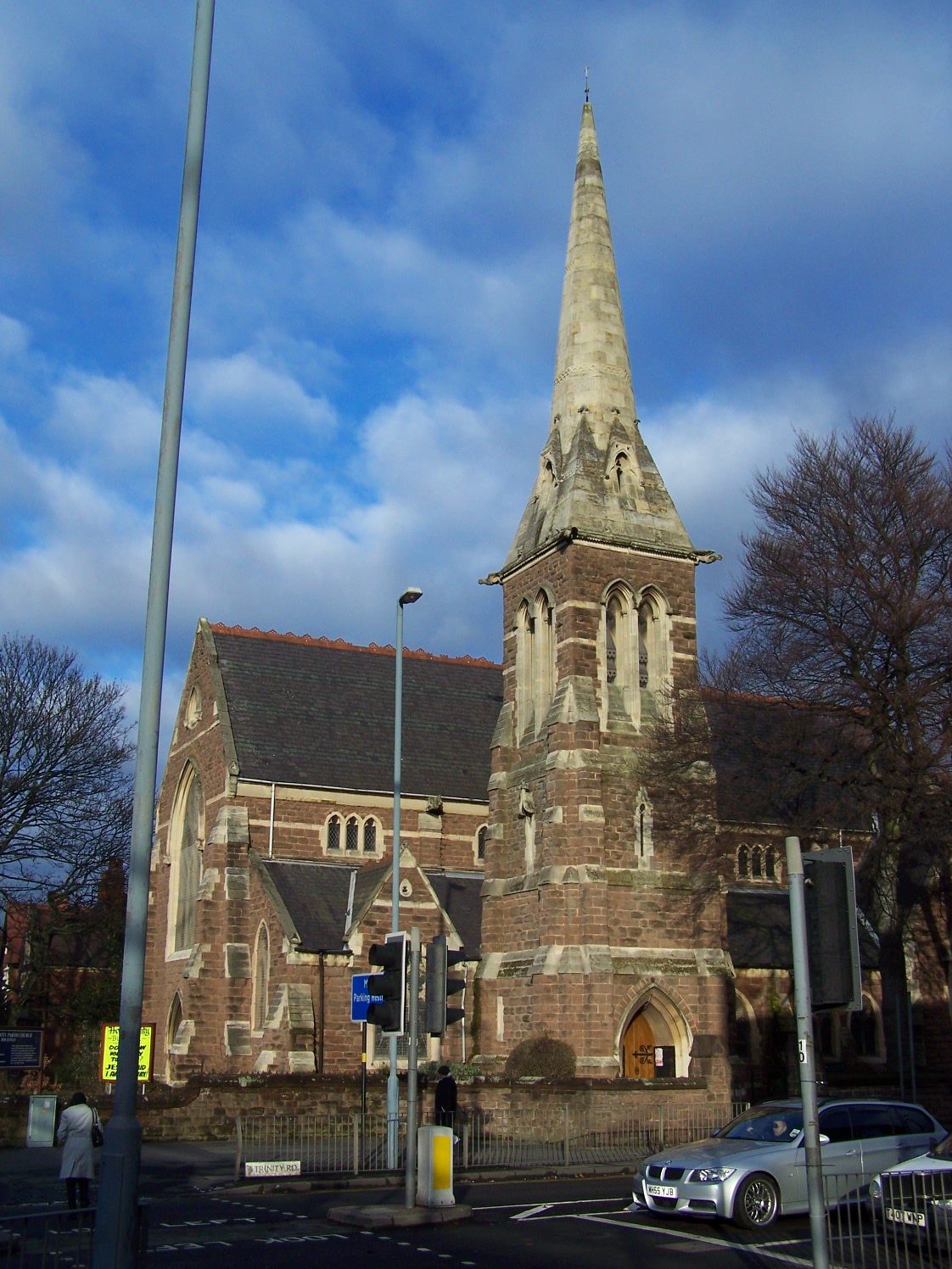
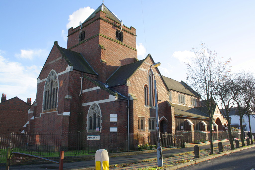
Holy Trinity Church, Birchfield

Holy Trinity Church is a Grade II* listed parish church in the Church of England in Birchfield, Birmingham. The church building was placed on a Heritage...

Murder of Charlene Ellis and Letisha Shakespeare

Two teenage girls, Charlene Ellis, 18, and Letisha Shakespeare, 17, were shot with a MAC-10 machine pistol, outside a hair salon in Birchfield Road, Aston...

Nearby Amenities

Located within 500m of 52.509255,-1.892998
Maxspeed Backward: 30 mph
Maxspeed Forward: 20 mph
Traffic Sign: maxspeed
Lat/Long: 52.5048485/-1.8943749
Noexit: yes
Source: bing
Lat/Long: 52.5059037/-1.8941499
Telephone
Booth: KX100
Covered: booth
Lat/Long: 52.5084273/-1.8894895
Post Box
Post Box Type: pillar
Postal Code: B6
Ref: B6 36
Royal Cypher: GR
Lat/Long: 52.5080455/-1.8917149
Telephone
Booth: KX100
Covered: booth
Lat/Long: 52.5116261/-1.8932554
Post Box
Post Box Type: pillar
Postal Code: B20
Ref: B20 321
Royal Cypher: EVIIR
Lat/Long: 52.5111525/-1.8922805
Post Box
Post Box Type: pillar
Ref: B6 199
Royal Cypher: EVIIR
Royal Cypher Wikidata: Q33102324
Lat/Long: 52.5065391/-1.8955543
Telephone
Booth: KX100
Covered: booth
Lat/Long: 52.5064529/-1.895923
Witton Rd / Prestbury Rd
Naptan AtcoCode: 43000264401
Naptan Bearing: NE
Naptan BusStopType: CUS
Naptan CommonName: Prestbury Rd
Naptan Indicator: opp
Naptan NaptanCode: nwmgjapg
Naptan PlusbusZoneRef: BHAMNWS
Naptan Status: ACT
Naptan StopType: BCT
Naptan Street: WITTON RD
Naptan Towards: Witton
Naptan Verified: no
Route Ref: 7;68C
Source: WMCA
Lat/Long: 52.5054491/-1.8945558
Bus Stop
Witton Rd / Prestbury Rd
Bus: yes
Naptan AtcoCode: 43000264402
Naptan Bearing: SW
Naptan BusStopType: MKD
Naptan CommonName: Prestbury Rd
Naptan Indicator: adj
Naptan NaptanCode: nwmgjapj
Naptan PlusbusZoneRef: BHAMNWS
Naptan Status: ACT
Naptan StopType: BCT
Naptan Street: WITTON RD
Naptan Towards: Birmingham
Naptan Verified: no
Public Transport: platform
Route Ref: 7;68A
Source: WMCA
Lat/Long: 52.5052328/-1.8946126
Bus Stop
Witton Rd / Trinity Rd
NaPTANAreaCode: 43000264501
Bus: yes
Naptan AtcoCode: 43000264501
Naptan Bearing: SW
Naptan BusStopType: MKD
Naptan CommonName: Trinity Rd
Naptan Indicator: before
Naptan NaptanCode: nwmgjapm
Naptan PlusbusZoneRef: BHAMNWS
Naptan Status: ACT
Naptan StopType: BCT
Naptan Street: WITTON RD
Naptan Towards: Birmingham
Naptan Verified: no
Public Transport: platform
Route Ref: 7;68A
Shelter: yes
Shelter Ref: 506010
Source: WMCA
Lat/Long: 52.508593/-1.891513
Bus Stop
Witton Rd / Trinity Rd
Bus: yes
Naptan AtcoCode: 43000264502
Naptan Bearing: NE
Naptan BusStopType: MKD
Naptan CommonName: Trinity Rd
Naptan Indicator: after
Naptan NaptanCode: nwmgjapt
Naptan PlusbusZoneRef: BHAMNWS
Naptan Status: ACT
Naptan StopType: BCT
Naptan Street: WITTON RD
Naptan Towards: Witton
Naptan Verified: no
Public Transport: platform
Route Ref: 7;68C
Source: WMCA
Lat/Long: 52.5086559/-1.8915276
Bus Stop
Witton Rd / Jardine Rd
NaPTANAreaCode: 43000265401
Bus: yes
Naptan AtcoCode: 43000265401
Naptan Bearing: SW
Naptan BusStopType: MKD
Naptan CommonName: Jardine Rd
Naptan Indicator: adj
Naptan NaptanCode: nwmgjatp
Naptan PlusbusZoneRef: BHAMNWS
Naptan Status: ACT
Naptan StopType: BCT
Naptan Street: WITTON RD
Naptan Towards: Birmingham
Naptan Verified: no
Public Transport: platform
Route Ref: 7;68A
Shelter: yes
Shelter Ref: 506009
Source: WMCA
Lat/Long: 52.5101437/-1.8887887
Bus Stop
Witton Rd / Jardine Rd
Bus: yes
Naptan AtcoCode: 43000265402
Naptan Bearing: NE
Naptan BusStopType: MKD
Naptan CommonName: Jardine Rd
Naptan Indicator: opp
Naptan NaptanCode: nwmgjatw
Naptan PlusbusZoneRef: BHAMNWS
Naptan Status: ACT
Naptan StopType: BCT
Naptan Street: WITTON RD
Naptan Towards: Witton
Naptan Verified: no
Public Transport: platform
Route Ref: 7;68C
Source: WMCA
Lat/Long: 52.5105679/-1.8883697
Bus Stop
Aston Lane / Witton Square
NaPTANAreaCode: 43000265502
Bus: yes
Fixme: Correct bus stop name?
Local Ref: WA
Naptan AtcoCode: 43000265502
Naptan Bearing: SE
Naptan BusStopType: MKD
Naptan CommonName: Witton Square
Naptan Indicator: before
Naptan NaptanCode: nwmgjawd
Naptan PlusbusZoneRef: BHAMNWS
Naptan Status: ACT
Naptan StopType: BCT
Naptan Street: ASTON LANE
Naptan Towards: Erdington
Naptan Verified: no
Public Transport: platform
Route Ref: 11C;68A;68C
Shelter: yes
Shelter Ref: 0265502
Source: WMCA
Towards: Stockland Green
Lat/Long: 52.512755/-1.8883664
Bus Stop
Witton Rd / Witton Square
NaPTANAreaCode: 43002600105
Bus: yes
Local Ref: WK
Naptan AtcoCode: 43002600105
Naptan Bearing: NE
Naptan BusStopType: MKD
Naptan CommonName: Witton Square
Naptan Indicator: before
Naptan NaptanCode: nwmpjpwg
Naptan PlusbusZoneRef: BHAMNWS
Naptan Status: ACT
Naptan StopType: BCT
Naptan Street: WITTON RD
Naptan Towards: Perry Common
Naptan Verified: no
Public Transport: platform
Route Ref: 7;68C
Shelter: yes
Shelter Ref: 506008
Source: WMCA
Lat/Long: 52.5114296/-1.8869971
Bus Stop
Witton Rd / Witton Square
NaPTANAreaCode: 43002600106
Bus: yes
Local Ref: WJ
Naptan AtcoCode: 43002600106
Naptan Bearing: SW
Naptan BusStopType: MKD
Naptan CommonName: Witton Square
Naptan Indicator: after
Naptan NaptanCode: nwmpjpwj
Naptan PlusbusZoneRef: BHAMNWS
Naptan Status: ACT
Naptan StopType: BCT
Naptan Street: WITTON RD
Naptan Towards: Birmingham
Naptan Verified: no
Public Transport: platform
Route Ref: 7;68A
Shelter: yes
Shelter Ref: 506007
Source: WMCA
Lat/Long: 52.5116041/-1.8868147
The Broadway / Witton Rd
Naptan AtcoCode: 43002602501
Naptan Bearing: SE
Naptan BusStopType: CUS
Naptan CommonName: Witton Rd
Naptan Indicator: before
Naptan NaptanCode: nwmpwjgt
Naptan PlusbusZoneRef: BHAMNWS
Naptan Status: ACT
Naptan StopType: BCT
Naptan Street: THE BROADWAY
Naptan Towards: Birmingham
Naptan Verified: no
Route Ref: 424;424E
Source: WMCA
Lat/Long: 52.5098593/-1.8901396
Bevington Rd / Broadway
Naptan AtcoCode: 43002604001
Naptan Bearing: N
Naptan BusStopType: CUS
Naptan CommonName: Broadway
Naptan Indicator: before
Naptan NaptanCode: nwmtadwm
Naptan PlusbusZoneRef: BHAMNWS
Naptan Status: ACT
Naptan StopType: BCT
Naptan Street: BEVINGTON RD
Naptan Towards: Perry Barr
Naptan Verified: no
Route Ref: 424;424E
Source: WMCA
Lat/Long: 52.5079637/-1.8893036
Bevington Rd / Broadway
Naptan AtcoCode: 43002604002
Naptan Bearing: S
Naptan BusStopType: CUS
Naptan CommonName: Broadway
Naptan Indicator: after
Naptan NaptanCode: nwmtadwp
Naptan PlusbusZoneRef: BHAMNWS
Naptan Status: ACT
Naptan StopType: BCT
Naptan Street: BEVINGTON RD
Naptan Towards: Birmingham
Naptan Verified: no
Route Ref: 424;424E
Source: WMCA
Lat/Long: 52.5079886/-1.8891837
Traffic Signals
Source: bing
Lat/Long: 52.5079913/-1.8918581
Traffic Signals
Source: bing
Lat/Long: 52.5081713/-1.8913451
Traffic Signals
Source: bing
Lat/Long: 52.5081735/-1.8919384
Traffic Signals
Source: bing
Lat/Long: 52.5083413/-1.8915057
Give Way
Direction: backward
Lat/Long: 52.5099304/-1.8904911
Surface: paving_stones
Traffic Calming: choker
Lat/Long: 52.5100015/-1.8906486
Give Way
Lat/Long: 52.5102214/-1.8886333
Ticket Office
Shop: ticket
Lat/Long: 52.5104642/-1.8866137
Man Made: surveillance
Source: survey
Lat/Long: 52.5050953/-1.8947148
Man Made: surveillance
Source: survey
Lat/Long: 52.5055256/-1.8930582
Ace
Office: estate_agent
Lat/Long: 52.5076826/-1.8919726
Aftab
Shop: hairdresser
Wheelchair: yes
Lat/Long: 52.5068281/-1.8932192
Al Baraka
Shop: clothes
Lat/Long: 52.507815/-1.8918526
Alpona
Shop: clothes
Lat/Long: 52.5079939/-1.8920598
As Saffar
Shop: travel_agency
Lat/Long: 52.5068029/-1.8932448
Asianaz Beauty Salon
Shop: beauty
Lat/Long: 52.5074762/-1.8921848
Place Of Worship
Birchfield Gospel Hall
Religion: christian
Lat/Long: 52.5079855/-1.8910018
Bismillah Hairdressers
Shop: hairdresser
Lat/Long: 52.5078858/-1.8917722
Hair Fusion
Shop: hairdresser
Lat/Long: 52.5076464/-1.8920099
Tuition
KS Tuition Centre
Lat/Long: 52.5068896/-1.8932493
Kandylicious
Shop: confectionery
Lat/Long: 52.5079152/-1.8917388
Khadim jew
Shop: jewelry
Lat/Long: 52.5075409/-1.8921183
Madani Memorials
Shop: funeral_directors
Lat/Long: 52.5075132/-1.8921467
Masum Travels & Money Transfer Services
Shop: travel_agency
Lat/Long: 52.5076321/-1.8924079
Miah Saab ta
Shop: travel_agency
Lat/Long: 52.5107201/-1.8877606
Oriental Car Spares
Shop: car_parts
Lat/Long: 52.5107437/-1.8877183
Pearl Properties
Office: estate_agent
Lat/Long: 52.5104595/-1.8882001
Fast Food
Pizza Shack
Lat/Long: 52.5075771/-1.8920811
RS
Office: accountant
Lat/Long: 52.5080496/-1.891634
Recycle Shop
Shop: clothes
Lat/Long: 52.507737/-1.8919254
Pharmacy
Roots Opticians
Healthcare: pharmacy
Shop: optician
Lat/Long: 52.507992/-1.8912522
Ruposhi Bangla (UK) Ltd
Shop: travel_agency
Lat/Long: 52.5069348/-1.8931062
Skyblue Connections
Shop: mobile_phone
Lat/Long: 52.5068956/-1.8931509
Stunfree
Shop: butcher
Lat/Long: 52.5077802/-1.8918911
Sylhet Bazaar
Shop: convenience
Lat/Long: 52.5078521/-1.8918105
Top Tailors
Shop: clothes
Lat/Long: 52.5079057/-1.8921349
UK Money
Shop: travel_agency
Lat/Long: 52.5068575/-1.8931831
Social Facility
Ummah Welfare Trust
Lat/Long: 52.5076124/-1.8920448
Witton PC Surgery
Shop: computer
Lat/Long: 52.510689/-1.8878082
Shop: furniture
Lat/Long: 52.507819/-1.8922245
Traffic Signals
Source: bing
Lat/Long: 52.5130689/-1.8893896
Traffic Signals
Source: bing
Lat/Long: 52.5132183/-1.8897866
Place Of Worship
Madrassa-tul-Madina Aston
Addr City: Birmingham
Addr Housenumber: 284
Addr Postcode: B6 6NU
Addr Street: Witton Road
Opening Hours: Mo-Fr 15:00-20:00
Religion: muslim
Website: https://www.dawateislami.net/
Lat/Long: 52.5090738/-1.890951
Give Way
Lat/Long: 52.5124282/-1.8878802
Give Way
Lat/Long: 52.5128363/-1.8889236
Give Way
Lat/Long: 52.5133336/-1.8899456
Traffic Calming: bump
Lat/Long: 52.5085275/-1.8894513
Traffic Calming: bump
Lat/Long: 52.5087487/-1.8887271
Give Way
Lat/Long: 52.5085242/-1.8886292
Give Way
Source: bing
Lat/Long: 52.5082802/-1.8893494
Give Way
Source: bing
Lat/Long: 52.5083434/-1.8893796
Give Way
Lat/Long: 52.509503/-1.8898295
Give Way
Lat/Long: 52.5095756/-1.88991
Give Way
Lat/Long: 52.5098604/-1.889238
Give Way
Lat/Long: 52.5105767/-1.8881323
Give Way
Lat/Long: 52.5106338/-1.8882221
Give Way
Lat/Long: 52.5102649/-1.8887774
Fire Hydrant
Emergency: fire_hydrant
Fire Hydrant Type: underground
Operator: WMFS
Source: survey
Lat/Long: 52.5098776/-1.8875952
Man Made: surveillance
Source: survey
Lat/Long: 52.5069538/-1.8889296
Post Box
Ref: B6 199
Lat/Long: 52.5084754/-1.8992427
Generator Method: photovoltaic
Generator Output Electricity: yes
Generator Source: solar
Generator Type: solar_photovoltaic_panel
Location: roof
Power: generator
Lat/Long: 52.5119279/-1.8877186
Generator Method: photovoltaic
Generator Output Electricity: yes
Generator Source: solar
Generator Type: solar_photovoltaic_panel
Location: roof
Power: generator
Lat/Long: 52.5104881/-1.8972659
Generator Method: photovoltaic
Generator Output Electricity: yes
Generator Source: solar
Generator Type: solar_photovoltaic_panel
Location: roof
Power: generator
Lat/Long: 52.5104783/-1.8971559
Generator Method: photovoltaic
Generator Output Electricity: yes
Generator Source: solar
Generator Type: solar_photovoltaic_panel
Location: roof
Power: generator
Lat/Long: 52.5091968/-1.8968233
Generator Method: photovoltaic
Generator Output Electricity: yes
Generator Source: solar
Generator Type: solar_photovoltaic_panel
Location: roof
Power: generator
Lat/Long: 52.5091838/-1.8970406
Generator Method: photovoltaic
Generator Output Electricity: yes
Generator Source: solar
Generator Type: solar_photovoltaic_panel
Location: roof
Power: generator
Lat/Long: 52.5096458/-1.8975127
Generator Method: photovoltaic
Generator Output Electricity: yes
Generator Source: solar
Generator Type: solar_photovoltaic_panel
Location: roof
Power: generator
Lat/Long: 52.5099282/-1.8976977
Generator Method: photovoltaic
Generator Output Electricity: yes
Generator Source: solar
Generator Type: solar_photovoltaic_panel
Location: roof
Power: generator
Lat/Long: 52.5098906/-1.896928
Generator Method: photovoltaic
Generator Output Electricity: yes
Generator Source: solar
Generator Type: solar_photovoltaic_panel
Location: roof
Power: generator
Lat/Long: 52.5094711/-1.8957317
Generator Method: photovoltaic
Generator Output Electricity: yes
Generator Source: solar
Generator Type: solar_photovoltaic_panel
Location: roof
Power: generator
Lat/Long: 52.5094515/-1.8955359
Generator Method: photovoltaic
Generator Output Electricity: yes
Generator Source: solar
Generator Type: solar_photovoltaic_panel
Location: roof
Power: generator
Lat/Long: 52.5090222/-1.8954769
Generator Method: photovoltaic
Generator Output Electricity: yes
Generator Source: solar
Generator Type: solar_photovoltaic_panel
Location: roof
Power: generator
Lat/Long: 52.5084435/-1.8951631
Generator Method: photovoltaic
Generator Output Electricity: yes
Generator Source: solar
Generator Type: solar_photovoltaic_panel
Location: roof
Power: generator
Lat/Long: 52.5084516/-1.8952489
Generator Method: photovoltaic
Generator Output Electricity: yes
Generator Source: solar
Generator Type: solar_photovoltaic_panel
Location: roof
Power: generator
Lat/Long: 52.5085039/-1.8958591
Generator Method: photovoltaic
Generator Output Electricity: yes
Generator Source: solar
Generator Type: solar_photovoltaic_panel
Location: roof
Power: generator
Lat/Long: 52.5087528/-1.8956687
Generator Method: photovoltaic
Generator Output Electricity: yes
Generator Source: solar
Generator Type: solar_photovoltaic_panel
Location: roof
Power: generator
Lat/Long: 52.5087561/-1.8957974
Generator Method: photovoltaic
Generator Output Electricity: yes
Generator Source: solar
Generator Type: solar_photovoltaic_panel
Location: roof
Power: generator
Lat/Long: 52.5089471/-1.8969427
Generator Method: photovoltaic
Generator Output Electricity: yes
Generator Source: solar
Generator Type: solar_photovoltaic_panel
Location: roof
Power: generator
Lat/Long: 52.5087912/-1.8961836
Generator Method: photovoltaic
Generator Output Electricity: yes
Generator Source: solar
Generator Type: solar_photovoltaic_panel
Location: roof
Power: generator
Lat/Long: 52.5087863/-1.8960589
Generator Method: photovoltaic
Generator Output Electricity: yes
Generator Source: solar
Generator Type: solar_photovoltaic_panel
Location: roof
Power: generator
Lat/Long: 52.5087732/-1.8959758
Generator Method: photovoltaic
Generator Output Electricity: yes
Generator Source: solar
Generator Type: solar_photovoltaic_panel
Location: roof
Power: generator
Lat/Long: 52.5085161/-1.8960066
Generator Method: photovoltaic
Generator Output Electricity: yes
Generator Source: solar
Generator Type: solar_photovoltaic_panel
Location: roof
Power: generator
Lat/Long: 52.5085226/-1.8960911
Generator Method: photovoltaic
Generator Output Electricity: yes
Generator Source: solar
Generator Type: solar_photovoltaic_panel
Location: roof
Power: generator
Lat/Long: 52.5085806/-1.8967228
Generator Method: photovoltaic
Generator Output Electricity: yes
Generator Source: solar
Generator Type: solar_photovoltaic_panel
Location: roof
Power: generator
Lat/Long: 52.5085765/-1.896653
Generator Method: photovoltaic
Generator Output Electricity: yes
Generator Source: solar
Generator Type: solar_photovoltaic_panel
Location: roof
Power: generator
Lat/Long: 52.5086124/-1.8970366
Generator Method: photovoltaic
Generator Output Electricity: yes
Generator Source: solar
Generator Type: solar_photovoltaic_panel
Location: roof
Power: generator
Lat/Long: 52.510049/-1.9002271
Generator Method: photovoltaic
Generator Output Electricity: yes
Generator Source: solar
Generator Type: solar_photovoltaic_panel
Location: roof
Power: generator
Lat/Long: 52.5095315/-1.8999025
Generator Method: photovoltaic
Generator Output Electricity: yes
Generator Source: solar
Generator Type: solar_photovoltaic_panel
Location: roof
Power: generator
Lat/Long: 52.5097894/-1.8998891
Generator Method: photovoltaic
Generator Output Electricity: yes
Generator Source: solar
Generator Type: solar_photovoltaic_panel
Location: roof
Power: generator
Lat/Long: 52.5101339/-1.8932748
Source: bing
Traffic Calming: bump
Lat/Long: 52.5103759/-1.8973759
Generator Method: photovoltaic
Generator Output Electricity: yes
Generator Source: solar
Generator Type: solar_photovoltaic_panel
Location: roof
Power: generator
Lat/Long: 52.5103326/-1.8876468
Addr City: Birmingham
Addr Postcode: B6 6HF
Addr Street: Trinity Road
Lat/Long: 52.5090058/-1.8863332
Give Way
Direction: forward
Lat/Long: 52.5100786/-1.890824
Give Way
Direction: backward
Lat/Long: 52.5101494/-1.8906966
Bicycle Parking
Bicycle Parking: stands
Capacity: 16
Covered: yes
Fee: no
Lat/Long: 52.5127044/-1.8955567
Give Way
Source: bing
Lat/Long: 52.5116153/-1.897691
Bicycle Parking
Bicycle Parking: stands
Capacity: 8
Covered: no
Lat/Long: 52.5084462/-1.8864884
Give Way
Source: bing
Lat/Long: 52.511448/-1.889348
Generator Method: photovoltaic
Generator Output Electricity: yes
Generator Source: solar
Generator Type: solar_photovoltaic_panel
Location: roof
Power: generator
Lat/Long: 52.5111688/-1.8979633
Generator Method: photovoltaic
Generator Output Electricity: yes
Generator Source: solar
Generator Type: solar_photovoltaic_panel
Location: roof
Power: generator
Lat/Long: 52.5124813/-1.8964157
Generator Method: photovoltaic
Generator Output Electricity: yes
Generator Source: solar
Generator Type: solar_photovoltaic_panel
Location: roof
Power: generator
Lat/Long: 52.5125352/-1.8964626
Generator Method: photovoltaic
Generator Output Electricity: yes
Generator Source: solar
Generator Type: solar_photovoltaic_panel
Location: roof
Power: generator
Lat/Long: 52.5126478/-1.8971264
Generator Method: photovoltaic
Generator Output Electricity: yes
Generator Source: solar
Generator Type: solar_photovoltaic_panel
Location: roof
Power: generator
Lat/Long: 52.5126404/-1.8970513
Fentham Store
Shop: convenience
Lat/Long: 52.5066824/-1.8950957
Parcel Locker
Brand: InPost
Brand Wikidata: Q3182097
Parcel Mail In: yes
Parcel Pickup: yes
Ref: UKBIR00018
Lat/Long: 52.5086385/-1.8977407
Recycling
Recycling Clothes: yes
Recycling Type: centre
Lat/Long: 52.5086195/-1.8977465
Parcel Locker
Brand: InPost
Brand Wikidata: Q3182097
Parcel Mail In: yes
Parcel Pickup: yes
Ref: UK00039441
Lat/Long: 52.5066526/-1.8950594
Recycling
Recycling Clothes: yes
Recycling Type: container
Lat/Long: 52.5066927/-1.8950101
The data included in this document is from www.openstreetmap.org. The data is made available under ODbL.

Have you been to Birchfield?

Leave your review of Birchfield below (or comments, questions and feedback).