Onecote

Settlement in Staffordshire Staffordshire Moorlands

England

Onecote

Holiday Let Property, Ford
Holiday Let Property, Ford Credit: Alex McGregor

Onecote is a small village located in the Staffordshire Moorlands district of Staffordshire, England. Situated in the heart of the Peak District National Park, it is surrounded by picturesque landscapes and stunning natural beauty. The village sits at an elevation of approximately 300 meters above sea level, offering breathtaking views of the surrounding countryside.

Onecote has a rich history dating back to medieval times, evidenced by its charming architecture and historic landmarks. The village is home to a quaint church, St. Luke's Church, which dates back to the 12th century and is known for its beautiful stained glass windows. The village also has a few traditional stone cottages that add to its scenic appeal.

Despite its small size, Onecote offers a range of amenities to its residents and visitors. There is a local pub, The Jervis Arms, which provides a cozy atmosphere and serves delicious food and beverages. The village also has a small convenience store for basic necessities.

For outdoor enthusiasts, Onecote is a paradise. It is surrounded by numerous walking trails and hiking routes, allowing visitors to explore the stunning Peak District landscape. The nearby Manifold Valley offers opportunities for cycling and rock climbing. The village is also close to the popular tourist destinations of Dovedale and Alton Towers, providing further entertainment options.

Onecote offers a peaceful and idyllic retreat for those seeking tranquility and natural beauty. With its rich history, stunning surroundings, and outdoor activities, it is a hidden gem within Staffordshire.

If you have any feedback on the listing, please let us know in the comments section below.
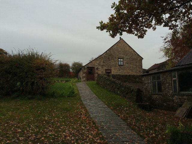
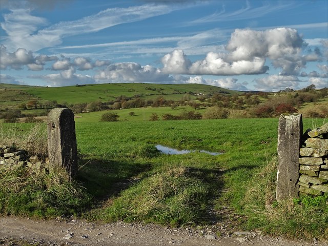
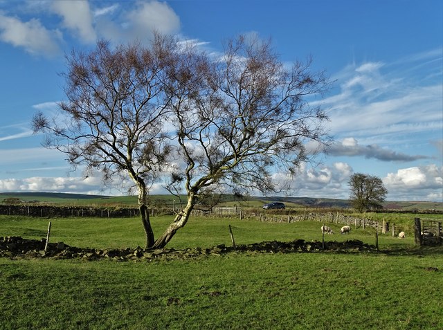
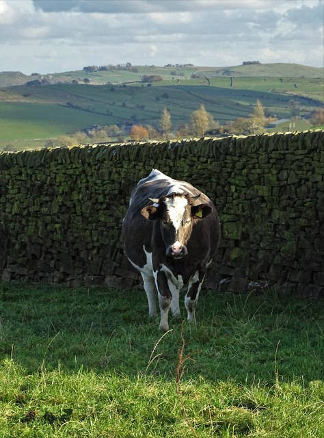
Onecote Images

Images are sourced within 2km of 53.093097/-1.927304 or Grid Reference SK0455. Thanks to Geograph Open Source API. All images are credited.

Holiday Let Property, Ford
New house
New house
Old Milepost by the B5053, Onecote parish Cast iron post by the B5053, in parish of ONECOTE (STAFFORDSHIRE MOORLANDS District), between Bottom House and Onecote, quarter mile South of Wetley Lane, in grass in front of drystone wall, on West side of road. Lathe iron casting, erected by the County Council in the 19th/20th century. 

Inscription reads:-
: ONECOTE 1 / WARSLOW 4¼ / LONGNOR 8½ / BUXTON 14½ : : ONECOTE : : IPSTONES 3 / FROGHALL 5 / LEEK 5½ / CHEADLE 8 :
Maker:-
: Chas. Lathe, Tipton. :

Grade II listed.  
List Entry Number: 1226310 <span class="nowrap"><a title="https://historicengland.org.uk/listing/the-list/list-entry/1226310" rel="nofollow ugc noopener" href="https://historicengland.org.uk/listing/the-list/list-entry/1226310">Link</a><img style="margin-left:2px;" alt="External link" title="External link - shift click to open in new window" src="https://s1.geograph.org.uk/img/external.png" width="10" height="10"/></span>

Milestone Society National ID: ST_CDBX08.
Old Milepost by the B5053, Onecote parish
Cast iron post by the B5053, in parish of ONECOTE (STAFFORDSHIRE MOORLANDS District), between Bottom House and Onecote, quarter mile South of Wetley Lane, in grass in front of drystone wall, on West side of road. Lathe iron casting, erected by the County Council in the 19th/20th century. Inscription reads:- : ONECOTE 1 / WARSLOW 4¼ / LONGNOR 8½ / BUXTON 14½ : : ONECOTE : : IPSTONES 3 / FROGHALL 5 / LEEK 5½ / CHEADLE 8 : Maker:- : Chas. Lathe, Tipton. : Grade II listed. List Entry Number: 1226310 LinkExternal link Milestone Society National ID: ST_CDBX08.
Old Milepost by the B5053, Onecote parish Cast iron post by the B5053, in parish of ONECOTE (STAFFORDSHIRE MOORLANDS District), Onecote village, 30m South of Fold Farmhouse, in grass in front of drystone wall, on Northwest side of road. Lathe iron casting, erected by the County Council in the 19th/20th century. 

Inscription reads:-
: WARSLOW 3¼ / LONGNOR 7½ / BUXTON 13½ : : ONECOTE : : IPSTONES 4 / FROGHALL 6 / LEEK 6½ / CHEADLE 9 :
Maker:-
: Chas. Lathe, Tipton. :

Grade II listed.  
List Entry Number: 1038176 <span class="nowrap"><a title="https://historicengland.org.uk/listing/the-list/list-entry/1038176" rel="nofollow ugc noopener" href="https://historicengland.org.uk/listing/the-list/list-entry/1038176">Link</a><img style="margin-left:2px;" alt="External link" title="External link - shift click to open in new window" src="https://s1.geograph.org.uk/img/external.png" width="10" height="10"/></span>

Milestone Society National ID: ST_CDBX09.
Old Milepost by the B5053, Onecote parish
Cast iron post by the B5053, in parish of ONECOTE (STAFFORDSHIRE MOORLANDS District), Onecote village, 30m South of Fold Farmhouse, in grass in front of drystone wall, on Northwest side of road. Lathe iron casting, erected by the County Council in the 19th/20th century. Inscription reads:- : WARSLOW 3¼ / LONGNOR 7½ / BUXTON 13½ : : ONECOTE : : IPSTONES 4 / FROGHALL 6 / LEEK 6½ / CHEADLE 9 : Maker:- : Chas. Lathe, Tipton. : Grade II listed. List Entry Number: 1038176 LinkExternal link Milestone Society National ID: ST_CDBX09.
Road near Cross Ways Farm Looking towards Bottom House.
Road near Cross Ways Farm
Looking towards Bottom House.
Covered reservoir near Moor Top On the road towards Bottom House.
Covered reservoir near Moor Top
On the road towards Bottom House.
Approaching Onecote The building ahead is the telephone exchange seen in this contribution by Roger W Haworth 14 years ago <a href="https://www.geograph.org.uk/photo/223832">SK0454 : Onecote Telephone Exchange</a>.
Approaching Onecote
The building ahead is the telephone exchange seen in this contribution by Roger W Haworth 14 years ago SK0454 : Onecote Telephone Exchange.
View of Onecote The church tower is seen above and beyond some farm buildings. Taken near Chapel House Farm.
View of Onecote
The church tower is seen above and beyond some farm buildings. Taken near Chapel House Farm.
Douse Lane, Onecote West of the village, a narrow lane with lovely flowering verges.
Douse Lane, Onecote
West of the village, a narrow lane with lovely flowering verges.
Mill Lea near Onecote
Onecote Grange, Staffordshire
The track to Mixon From Onecote Grange
The track to Mixon
From Onecote Grange
At Mixon - junction of tracks
Young bull above The River Hamps He was guarding the public right of way, causing me to divert into the adjacent field.
Young bull above The River Hamps
He was guarding the public right of way, causing me to divert into the adjacent field.
In Onecote looking to St Luke's Church
Staffordshire Countryside Looking north from Far Moor
Staffordshire Countryside
Looking north from Far Moor
Tree near Malbon House Farm
Cow by a wall near Malbon House Farm
Show me another place!

Onecote is located at Grid Ref: SK0455 (Lat: 53.093097, Lng: -1.927304)

Administrative County: Staffordshire

District: Staffordshire Moorlands

Police Authority: Staffordshire

What 3 Words

///pitching.winners.notifying. Near Leek, Staffordshire

Nearby Locations

Onecote

Related Wikis

Onecote

Onecote is a village and civil parish on the B5053 road, near Leek, in the Staffordshire Moorlands district, in the county of Staffordshire, England. The...

Morridge

Morridge is a geographical feature, a few mile east of Leek, in Staffordshire, England. It is in the local government district of Staffordshire Moorlands...

Butterton

Butterton is a small village in the Staffordshire Peak District of England (grid reference SK075565). It overlooks the Manifold Valley and Ecton Hill,...

St Bartholomew's Church, Butterton

St Bartholomew's Church, Butterton is a Grade II listed parish church in the Church of England in Butterton. == History == St Bartholomew's Church was...

Nearby Amenities

Located within 500m of 53.093097,-1.927304
Onecote
Is In: Staffordshire, United Kingdom
Place: village
Lat/Long: 53.0929598/-1.9278453
Bus Stop
Jervis Arms PH
Naptan AtcoCode: 3800C811000
Naptan Bearing: S
Naptan CommonName: Jervis Arms PH
Naptan Indicator: Opp
Naptan Landmark: Jervis Arms PH
Naptan Street: Main Rd
Naptan Verified: no
Source: naptan_import
Lat/Long: 53.0931502/-1.9271868
Post Office
Naptan AtcoCode: 3800C811001
Naptan Bearing: N
Naptan BusStopType: CUS
Naptan CommonName: Post Office
Naptan Indicator: Opp
Naptan Landmark: Post Office
Naptan Street: Main Rd
Naptan Verified: no
Source: naptan_import
Lat/Long: 53.0930695/-1.927411
Pub
Jervis Arms
Ele: 279.8673096
Food: yes
Real Ale: 6x, Titanic Iceberg +4 others (varies)
Lat/Long: 53.0939874/-1.9265793
Post Box
Ele: 283.9528809
Post Box Type: lamp
Lat/Long: 53.0930099/-1.9272374
Bench
Ele: 284.1933594
Lat/Long: 53.0930971/-1.9274703
Barrier: stile
Ele: 307.5051270
Steps: 0
Stile: stepover
Lat/Long: 53.0932471/-1.9344074
Barrier: stile
Ele: 308.7066650
Steps: 1
Stile: stepover
Lat/Long: 53.0932401/-1.9342946
Ele: 307
Lat/Long: 53.0931757/-1.9341727
Telephone
Booth: K6
Covered: booth
Ele: 283.2319336
Man Made: telephone_box
Old Phone: +44 1538 304311
Lat/Long: 53.0927998/-1.927588
Barrier: stile
Material: wood
Source: survey;gps
Stile: stepover
Lat/Long: 53.095216/-1.9254008
Barrier: stile
Material: stone
Source: survey;gps
Stile: stepover
Lat/Long: 53.0946632/-1.9236884
Barrier: stile
Fixme: Presumably there is a fence here?
Lat/Long: 53.093766/-1.9226724
Barrier: stile
Material: wood
Source: survey;gps
Stile: stepover
Lat/Long: 53.0927227/-1.9211038
Barrier: stile
Lat/Long: 53.0963116/-1.9243394
Barrier: stile
Material: stone
Source: survey;gps
Stile: squeezer
Lat/Long: 53.0968535/-1.9272497
Barrier: stile
Material: stone
Source: survey;gps
Stile: squeezer
Lat/Long: 53.09686/-1.9313697
Barrier: stile
Material: wood
Source: survey;gps
Stile: stepover
Lat/Long: 53.096209/-1.9242222
Barrier: stile
Material: wood
Source: survey;gps
Stile: stepover
Lat/Long: 53.0964989/-1.9229521
Barrier: stile
Material: wood
Source: survey;gps
Stile: stepover
Lat/Long: 53.0888148/-1.9265481
Barrier: stile
Material: wood
Source: survey;gps
Stile: stepover
Lat/Long: 53.0888639/-1.928063
Barrier: stile
Material: steel
Source: survey;gps
Stile: squeezer
Lat/Long: 53.0889548/-1.9292218
Barrier: stile
Material: wood
Source: survey;gps
Stile: stepover
Lat/Long: 53.0888611/-1.9257486
Barrier: stile
Material: steel
Source: survey;gps
Stile: squeezer
Lat/Long: 53.0920096/-1.927688
Addr Housename: Gable Cottage
Lat/Long: 53.0933135/-1.9268585
Addr Housename: Garden Cottage
Lat/Long: 53.0934083/-1.926747
Addr Housename: Moorland House
Lat/Long: 53.0933682/-1.9268014
Barrier: entrance
Source: survey;gps
Lat/Long: 53.0894103/-1.9253338
Barrier: stile
Material: wood
Source: survey;gps
Stile: stepover
Lat/Long: 53.0916051/-1.9270048
Generator Source: solar
Power: generator
Lat/Long: 53.0892961/-1.9309974
Generator Source: solar
Power: generator
Lat/Long: 53.0893106/-1.9311094
Shelter
Shelter Type: public_transport
Lat/Long: 53.0929394/-1.927305
Direction: 315
Lit: no
Maxspeed: 30 mph
Traffic Sign: maxspeed
Lat/Long: 53.0951274/-1.9306253
Direction: 315
Lit: no
Maxspeed: 30 mph
Traffic Sign: maxspeed
Lat/Long: 53.0950846/-1.9306936
Direction: 135
Lit: no
Maxspeed: national
Traffic Sign: maxspeed
Lat/Long: 53.0950809/-1.9306875
Direction: 135
Lit: no
Maxspeed: national
Traffic Sign: maxspeed
Lat/Long: 53.0951231/-1.9306196
Direction: 200
Lit: no
Maxspeed: 30 mph
Traffic Sign: maxspeed
Lat/Long: 53.0897586/-1.9289537
Direction: 20
Lit: no
Maxspeed: national
Traffic Sign: maxspeed
Lat/Long: 53.0897637/-1.9289507
Direction: 20
Lit: no
Maxspeed: national
Traffic Sign: maxspeed
Lat/Long: 53.0897398/-1.9288251
Direction: 200
Lit: no
Maxspeed: 30 mph
Traffic Sign: maxspeed
Lat/Long: 53.0897357/-1.928827
The data included in this document is from www.openstreetmap.org. The data is made available under ODbL.

Have you been to Onecote?

Leave your review of Onecote below (or comments, questions and feedback).