Bieldside

Settlement in Aberdeenshire

Scotland

Bieldside

Road near to Westerton Looking southward.
Road near to Westerton Credit: Peter Wood

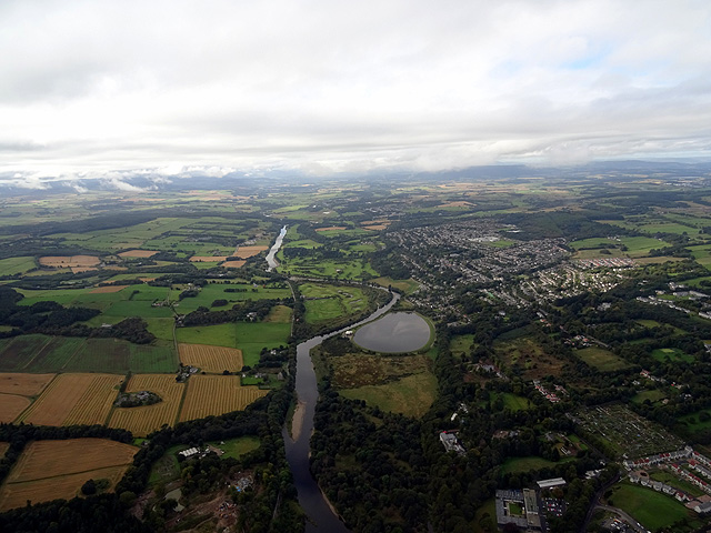
Bieldside is a small suburban village located in Aberdeenshire, Scotland. Situated approximately 5 miles west of the city of Aberdeen, it is nestled within the picturesque Deeside area. Bieldside is known for its tranquil and scenic surroundings, with the majestic Grampian Mountains providing a stunning backdrop.

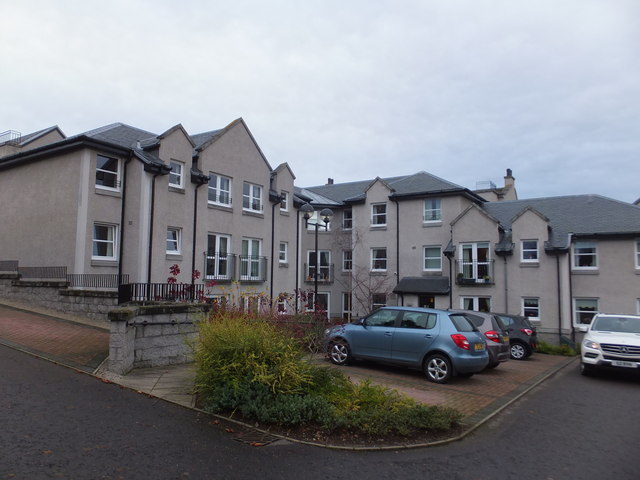
The village is primarily residential, consisting of a mix of traditional stone-built houses and more modern properties. Its charm lies in the peaceful atmosphere and the abundance of green spaces, including well-maintained gardens and lush parks. Bieldside offers residents a sense of rural living while still being within easy reach of the amenities and services of Aberdeen city.

The village benefits from excellent transport links, with regular bus services connecting it to Aberdeen and other nearby towns. The nearby Aberdeen Western Peripheral Route also provides convenient access to the wider Aberdeenshire region and beyond.

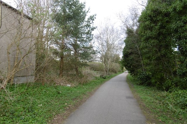
Bieldside is home to a close-knit community, with a range of amenities catering to the needs of its residents. These include a local primary school, a post office, and a village hall that hosts various community events. Nearby, residents can enjoy leisure activities such as golfing at the prestigious Deeside Golf Club or exploring the beautiful countryside through various walking and cycling routes.

Overall, Bieldside offers a serene and idyllic setting for those seeking a peaceful lifestyle close to nature, while still benefiting from the convenience of nearby urban amenities.

If you have any feedback on the listing, please let us know in the comments section below.

Bieldside Images

Images are sourced within 2km of 57.112667/-2.1970076 or Grid Reference NJ8802. Thanks to Geograph Open Source API. All images are credited.

Road near to Westerton Looking southward.
Road near to Westerton
Looking southward.
Shallow Concrete Trough in a Wall This peculiar low long block is incorporated into a stone wall between fields outside Milltimber, an outer suburb of Aberdeen at its Western side. Whether this was its original purpose is unclear, though it was certainly used as a trough at some point judging by the blue pipes embedded within it. Could it have originally been a section of a long channel designed for water or blood and has been repurposed? Or was it specifically designed to hold water and maintained the water level by some clever cistern tank-like system? It would be interesting to know how long large metal water troughs have been around for at affordable prices. If this is an older version it holds a fraction of the water of today's ones.
Shallow Concrete Trough in a Wall
This peculiar low long block is incorporated into a stone wall between fields outside Milltimber, an outer suburb of Aberdeen at its Western side. Whether this was its original purpose is unclear, though it was certainly used as a trough at some point judging by the blue pipes embedded within it. Could it have originally been a section of a long channel designed for water or blood and has been repurposed? Or was it specifically designed to hold water and maintained the water level by some clever cistern tank-like system? It would be interesting to know how long large metal water troughs have been around for at affordable prices. If this is an older version it holds a fraction of the water of today's ones.
St Devenick's Bieldside
A93, Bieldside
A93, Bieldside
A93, Bieldside
A93, Bieldside
Cult's Kirk Sanctuary
OS Cut Mark - Bieldside, Bieldside Inn <span class="nowrap"><a title="https://www.bench-marks.org.uk/bm84439" rel="nofollow ugc noopener" href="https://www.bench-marks.org.uk/bm84439">Link</a><img style="margin-left:2px;" alt="External link" title="External link - shift click to open in new window" src="https://s1.geograph.org.uk/img/external.png" width="10" height="10"/></span>
OS Cut Mark - Bieldside, Bieldside Inn
Location of OS Cut Mark - Bieldside, Bieldside Inn
Craigton Road
Craigton Road
Murtle Den Crescent, Milltimber, Aberdeen Murtle Den Crescent leads into Oldfold Park, a recently-built housing development in Milltimber, on the outskirts of Aberdeen.
Murtle Den Crescent, Milltimber, Aberdeen
Murtle Den Crescent leads into Oldfold Park, a recently-built housing development in Milltimber, on the outskirts of Aberdeen.
St Mary's Chapel The massive, cathedral-like St Mary's Chapel is part of the former Blairs College Roman Catholic seminary. The college complex, incorporating several phases of building and a very large site, closed in the 1980s but the chapel remains open for regular services and for visitors. A small museum and tea room is open throughout the year, and displays some of the College's Catholic art collection, including medieval vestments and the memorial portrait of Mary, Queen of Scots. The college and chapel are built in the former estate lands of John Menzies of Pitfodels who donated the estate to the Catholic Church. The site is in open countryside, close to the banks of the River Dee and set amongst former park land with avenues of trees and straight-edged fields. 

St Mary's Chapel was built as part of a new range for the college, using generous funding by Major Lennon of Liverpool. The chapel is built onto the U-plan range of New College, built from 1898. The chapel itself, to the east of the college, was started in 1899 with Robert Curran as architect.
St Mary's Chapel
The massive, cathedral-like St Mary's Chapel is part of the former Blairs College Roman Catholic seminary. The college complex, incorporating several phases of building and a very large site, closed in the 1980s but the chapel remains open for regular services and for visitors. A small museum and tea room is open throughout the year, and displays some of the College's Catholic art collection, including medieval vestments and the memorial portrait of Mary, Queen of Scots. The college and chapel are built in the former estate lands of John Menzies of Pitfodels who donated the estate to the Catholic Church. The site is in open countryside, close to the banks of the River Dee and set amongst former park land with avenues of trees and straight-edged fields. St Mary's Chapel was built as part of a new range for the college, using generous funding by Major Lennon of Liverpool. The chapel is built onto the U-plan range of New College, built from 1898. The chapel itself, to the east of the college, was started in 1899 with Robert Curran as architect.
Sheltered housing at Manor Place, Cults
Shakkin' Briggie south tower and pier The south tower and pier of the Shakkin' Briggie.  This is the only part of the bridge with the deck still in place.
Shakkin' Briggie south tower and pier
The south tower and pier of the Shakkin' Briggie. This is the only part of the bridge with the deck still in place.
Cattle by Blair In a field by Batchart these highland cattle graze with Bair College behind.
Cattle by Blair
In a field by Batchart these highland cattle graze with Bair College behind.
Inchgarth Reservoir and the River Dee Viewed from a flight from Aberdeen to Birmingham.
Inchgarth Reservoir and the River Dee
Viewed from a flight from Aberdeen to Birmingham.
Supermarket,  Cults
Supermarket, Cults
Cults Station Like many stations on the Deeside Railway, the platform survives.
Cults Station
Like many stations on the Deeside Railway, the platform survives.
Deeside Railway, Cults Closed in 1968 and now a cycle/footpath.
Deeside Railway, Cults
Closed in 1968 and now a cycle/footpath.
Show me another place!

Bieldside is located at Grid Ref: NJ8802 (Lat: 57.112667, Lng: -2.1970076)

Unitary Authority: City of Aberdeen

Police Authority: North East

What 3 Words

///ruby.option.bliss. Near Cults, Aberdeen

Nearby Locations

Bieldside

Related Wikis

Bieldside

Bieldside is a suburb to the west of Aberdeen City Centre, Scotland. Together with the neighbouring suburb of Cults, it is the wealthiest area in Scotland...

Bieldside railway station

Bieldside railway station served the Bieldside area within the parish of Peterculter from 1897 to 1937 on the Deeside Railway that ran from Aberdeen (Joint...

Cults Academy

Cults Academy is an Aberdeen City Council secondary school in Cults, Aberdeen, Scotland. It was the recipient of The Sunday Times Scottish State Secondary...

West Cults railway station

West Cults railway station served the small suburban village of West Cults area within the parish of Peterculter from 1894 to 1937 on the Deeside Railway...

Murtle railway station

Murtle railway station, later Murtle Halt railway station served Murtle and Beaconhill Houses and estates, the Mill of Murtle, Milton of Murtle, the local...

Cults, Aberdeen

Cults ( KULTS) is a suburb on the western edge of Aberdeen, Scotland. It lies on the banks of the River Dee and marks the eastern boundary of Royal Deeside...
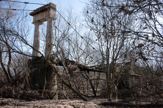
Shakkin' Briggie

St. Devenick's Bridge (locally known as the Shakkin' Briggie, or as Morison's Bridge) is a disused suspension footbridge which crosses the River Dee from...

Blairs College

St Mary's College, Blairs (commonly known as Blairs College), situated near Aberdeen in Scotland, was from 1829 to 1986 a junior seminary for boys and...

Nearby Amenities

Located within 500m of 57.112667,-2.1970076
Traffic Calming: cushion
Lat/Long: 57.1169612/-2.1948801
Traffic Signals
Traffic Signals: signal
Lat/Long: 57.1126571/-2.1970329
Turning Circle
Lat/Long: 57.1134828/-2.2029902
Newton Dee Store
Shop: convenience
Toilets Wheelchair: yes
Wheelchair: yes
Lat/Long: 57.1100781/-2.200515
Cafe
Newton Dee Café
Toilets: yes
Toilets Wheelchair: yes
Wheelchair: yes
Lat/Long: 57.1099849/-2.2000429
Bieldside
Place: suburb
Wikidata: Q4904446
Wikipedia: en:Bieldside
Lat/Long: 57.1147638/-2.2032614
Power: tower
Lat/Long: 57.1091769/-2.2016011
Power: tower
Lat/Long: 57.1130622/-2.2027161
Post Box
Lat/Long: 57.1123511/-2.1985974
Pub
The Bieldside
Addr City: Aberdeen
Addr Housenumber: 37
Addr Postcode: AB15 9DB
Addr Street: North Deeside Road
Fhrs Authority: Aberdeen City
Fhrs Id: 1342446
Fhrs Local Authority Id: EHDC14066
Source Addr: fhrs
Lat/Long: 57.1125031/-2.1971544
Barrier: bollard
Lat/Long: 57.1112741/-2.2017473
Scotmid
Brand: Scotmid
Brand Wikidata: Q7435719
Brand Wikipedia: en:Scotmid
Shop: convenience
Lat/Long: 57.1124101/-2.1977752
Cairn - prehistoric
Historic: archaeological_site
Lat/Long: 57.1159907/-2.1941854
Bus Stop
Cairn Road
Bench: no
Bin: no
Bus: yes
Lit: yes
Naptan AtcoCode: 639006791
Naptan CommonName: Cairn Road
Naptan Indicator: opp
Naptan NaptanCode: 23232484
Naptan Verified: no
Public Transport: platform
Shelter: no
Source: bing; gps
Tactile Paving: no
Lat/Long: 57.113047/-2.1936954
Bus Stop
Prospecthill Road
Bench: no
Bin: no
Bus: yes
Lit: yes
Naptan AtcoCode: 639006812
Naptan CommonName: Prospecthill Road
Naptan Indicator: at
Naptan NaptanCode: 23232475
Naptan Verified: no
Public Transport: platform
Shelter: no
Source: bing; gps
Tactile Paving: no
Lat/Long: 57.1120322/-2.2010576
Bus Stop
Prospecthill Road
Bench: no
Bin: no
Bus: yes
Lit: yes
Naptan AtcoCode: 639006811
Naptan CommonName: Prospecthill Road
Naptan Indicator: opp
Naptan NaptanCode: 23232473
Naptan Verified: no
Public Transport: platform
Shelter: no
Source: bing; gps
Tactile Paving: no
Lat/Long: 57.1120558/-2.2002577
Bus Stop
Baillieswells Road
Bench: yes
Bin: yes
Bus: yes
Lit: yes
Naptan AtcoCode: 639006802
Naptan CommonName: Baillieswells Road
Naptan Indicator: opp
Naptan NaptanCode: 23232474
Naptan Verified: no
Public Transport: platform
Shelter: yes
Source: bing; gps
Tactile Paving: no
Lat/Long: 57.1125928/-2.1977545
Bus Stop
Bieldside Station Road
Bench: no
Bin: no
Bus: yes
Lit: yes
Naptan AtcoCode: 639006801
Naptan CommonName: Bieldside Station Road
Naptan Indicator: at
Naptan NaptanCode: 23232479
Naptan Verified: no
Public Transport: platform
Shelter: no
Source: bing; gps
Tactile Paving: no
Lat/Long: 57.1127969/-2.1960346
Bus Stop
Cairn Road
Bench: no
Bin: no
Bus: yes
Lit: yes
Naptan AtcoCode: 639006792
Naptan CommonName: Cairn Road
Naptan Indicator: at
Naptan NaptanCode: 23232485
Naptan Verified: no
Public Transport: platform
Shelter: no
Source: bing; gps
Tactile Paving: no
Lat/Long: 57.113121/-2.194269
Bus Stop
Quarry Road
Bench: yes
Bin: yes
Bus: yes
Lit: yes
Naptan AtcoCode: 639006782
Naptan CommonName: Quarry Road
Naptan Indicator: at
Naptan NaptanCode: 23232489
Naptan Verified: no
Public Transport: platform
Shelter: yes
Source: bing; gps
Tactile Paving: no
Lat/Long: 57.1141382/-2.1894897
Power: tower
Lat/Long: 57.1105767/-2.202003
Power: tower
Lat/Long: 57.11113/-2.2021597
Power: tower
Lat/Long: 57.1122623/-2.2024825
Traffic Calming: bump
Lat/Long: 57.1106783/-2.1947608
Bieldside
Historic Railway: station
Wikidata: Q62024537
Wikipedia: en:Bieldside railway station
Lat/Long: 57.1113961/-2.1961763
Noexit: yes
Lat/Long: 57.1121253/-2.1969447
Golf: pin
Ref: 18
Lat/Long: 57.1115717/-2.1896126
Traffic Calming: island
Lat/Long: 57.1118172/-2.2019133
Waste Basket
Survey Date: 2021-08-02
Waste: dog_excrement
Lat/Long: 57.1108772/-2.2006303
Noexit: yes
Lat/Long: 57.1088508/-2.1977176
Generator Method: photovoltaic
Generator Output Electricity: yes
Generator Source: solar
Generator Type: solar_photovoltaic_panel
Power: generator
Lat/Long: 57.112363/-2.1974286
Parking
Parking: surface
Lat/Long: 57.1164424/-2.2005795
Noexit: yes
Lat/Long: 57.1132061/-2.1973562
The data included in this document is from www.openstreetmap.org. The data is made available under ODbL.

Have you been to Bieldside?

Leave your review of Bieldside below (or comments, questions and feedback).