Basing, Old

Settlement in Hampshire Basingstoke and Deane

England

Basing, Old

Basing Road (to nowhere)
Basing Road (to nowhere) Credit: Mr Ignavy

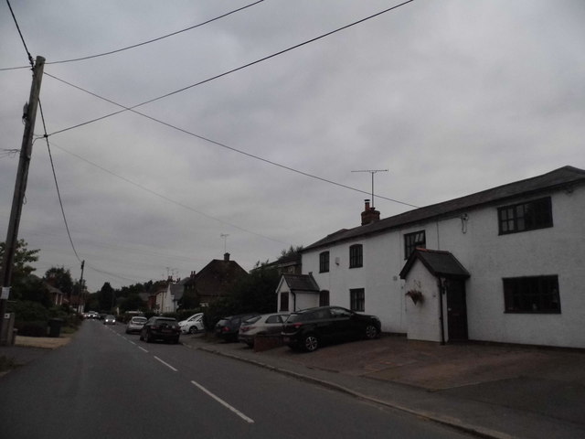
Basing, Old, Hampshire is a historic village located in the county of Hampshire, England. Situated approximately 48 miles southwest of London, Basing is renowned for its rich heritage and picturesque surroundings. The village is nestled within the Basingstoke and Deane district, close to the River Loddon and surrounded by lush green countryside.

Dating back to Roman times, Basing has a long and fascinating history. It was once home to a Roman settlement, evidenced by the discovery of various artifacts and ruins. The village grew in importance during the medieval period when Basing Castle was constructed. The castle played a prominent role in the English Civil War and was famously besieged and destroyed by Oliver Cromwell's forces in 1645.

Today, remnants of Basing Castle can still be seen, including sections of its protective walls and earthworks. The village also boasts an impressive 12th-century church, St. Mary's Church, which features stunning Norman architecture and intricate stained glass windows.

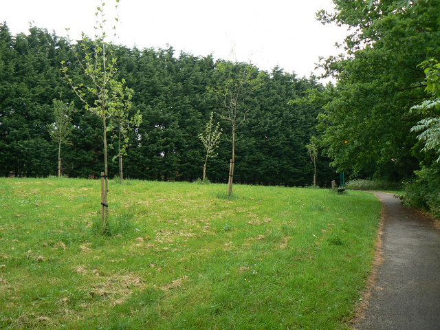
Basing is a close-knit community with a small population, contributing to its charming and peaceful atmosphere. The village is home to a local pub, The White Hart, which provides a welcoming spot for residents and visitors alike. Additionally, Basing offers beautiful walks and trails, allowing visitors to explore the idyllic countryside and enjoy the tranquility of the area.

With its historical significance, natural beauty, and friendly community, Basing, Old, Hampshire is a captivating destination for those seeking a glimpse into England's past and a peaceful retreat in the heart of the countryside.

If you have any feedback on the listing, please let us know in the comments section below.

Basing, Old Images

Images are sourced within 2km of 51.271796/-1.039945 or Grid Reference SU6752. Thanks to Geograph Open Source API. All images are credited.

Basing Road (to nowhere)
The Street - Old Basing
Always popular - Bartons Mill
Chineham car park
Chineham car park
Centre of Old Basing I wonder how the railway was received when it was first built through the old village.
Centre of Old Basing
I wonder how the railway was received when it was first built through the old village.
An old house in Old Basing
Footbridge over the M3 The M3 motorway runs for 59 miles from Sunbury-on-Thames to Southampton. Construction started 1968 and was finally completed in 1995. The Winchester bypass through Twyford Downs was the most controversial section to be built.
Wikipedia: <span class="nowrap"><a title="http://en.wikipedia.org/wiki/M3_motorway_(Great_Britain)" rel="nofollow ugc noopener" href="http://en.wikipedia.org/wiki/M3_motorway_(Great_Britain)">Link</a><img style="margin-left:2px;" alt="External link" title="External link - shift click to open in new window" src="https://s1.geograph.org.uk/img/external.png" width="10" height="10"/></span>
Footbridge over the M3
The M3 motorway runs for 59 miles from Sunbury-on-Thames to Southampton. Construction started 1968 and was finally completed in 1995. The Winchester bypass through Twyford Downs was the most controversial section to be built. Wikipedia: LinkExternal link
M3, eastbound The M3 motorway runs for 59 miles from Sunbury-on-Thames to Southampton. Construction started 1968 and was finally completed in 1995. The Winchester bypass through Twyford Downs was the most controversial section to be built.
Wikipedia: <span class="nowrap"><a title="http://en.wikipedia.org/wiki/M3_motorway_(Great_Britain)" rel="nofollow ugc noopener" href="http://en.wikipedia.org/wiki/M3_motorway_(Great_Britain)">Link</a><img style="margin-left:2px;" alt="External link" title="External link - shift click to open in new window" src="https://s1.geograph.org.uk/img/external.png" width="10" height="10"/></span>
M3, eastbound
The M3 motorway runs for 59 miles from Sunbury-on-Thames to Southampton. Construction started 1968 and was finally completed in 1995. The Winchester bypass through Twyford Downs was the most controversial section to be built. Wikipedia: LinkExternal link
Ford at Mapledurwell This is the first of three fords along the byway at Mapledurwell.
Ford at Mapledurwell
This is the first of three fords along the byway at Mapledurwell.
Ford on the Lyde River This is the third of the three Mapledurwell fords on the byway leading down to London Road.
Ford on the Lyde River
This is the third of the three Mapledurwell fords on the byway leading down to London Road.
Ford at Mapledurwell This is the second of the three Mapledurwell fords.
Ford at Mapledurwell
This is the second of the three Mapledurwell fords.
Pyotts Hill, Old Basing This is one of the original villages surrounding Basingstoke before it became built up.
Pyotts Hill, Old Basing
This is one of the original villages surrounding Basingstoke before it became built up.
The track to Blacklands Farm
Newnham Lane near Old Basing
Poors Farm Road at the junction of Newnham Lane This is an archetypal green triangle rural junction
Poors Farm Road at the junction of Newnham Lane
This is an archetypal green triangle rural junction
Pyotts Hill, Chineham
Show me another place!

Basing, Old is located at Grid Ref: SU6752 (Lat: 51.271796, Lng: -1.039945)

Administrative County: Hampshire

District: Basingstoke and Deane

Police Authority: Hampshire

What 3 Words

///buck.ranch.shack. Near Old Basing, Hampshire

Related Wikis

Old Basing

Old Basing is a village in Hampshire, England, just east of Basingstoke. It was called Basengum in the Anglo-Saxon Chronicle and Basinges in the Domesday...

Battle of Basing

The Battle of Basing was a victory of a Danish Viking army over the West Saxons at the royal estate of Basing in Hampshire on about 22 January 871.In late...

Lychpit

Lychpit is now the name of a modern housing development adjacent to Old Basing near Basingstoke, Hampshire. The modern development started in the early...

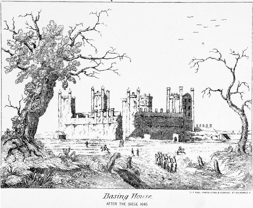
Siege of Basing House

The siege of Basing House near Basingstoke in Hampshire, was a Parliamentarian victory late in the First English Civil War. Whereas the title of the event...

The Mill Field, Hampshire

The Mill Field is a 11.7-hectare (29-acre) Local Nature Reserve in Basingstoke in Hampshire. It is owned by Basingstoke and Deane Borough Council and...

Basing House

Basing House was a Tudor palace and castle in the village of Old Basing in the English county of Hampshire. It once rivalled Hampton Court Palace in its...

Daneshill Park Woods

Daneshill Park Woods is a 4.4-hectare (11-acre) Local Nature Reserve in Basingstoke in Hampshire. It is owned and managed by Basingstoke and Deane Borough...

Andwell

Andwell is a village and former civil parish, now in the parish of Mapledurwell and Up Nately, in the Basingstoke and Deane district of Hampshire, England...

Nearby Amenities

Located within 500m of 51.271796,-1.039945
Turning Circle
Lat/Long: 51.2729721/-1.045438
Barrier: bollard
Lat/Long: 51.2690972/-1.0430105
Public Building
Beddington Centre
Lat/Long: 51.2752595/-1.0444625
Old Basing News
Note: This used to be Old Basing Post Office
Shop: convenience
Lat/Long: 51.2684093/-1.0397116
Restaurant
Basing Chinese Takeaway
Note: chinese takeaway
Lat/Long: 51.2684341/-1.0397767
Cut and Run Barbers
Addr City: Basingstoke
Addr Housename: Belle Vue Parade
Addr Housenumber: 42
Addr Postcode: RG24 7JU
Addr Street: Belle Vue Road
Operator: Premier
Shop: hairdresser
Lat/Long: 51.2684895/-1.039918
Old Basing
Is In: Hampshire, England, UK
Place: village
Wikidata: Q1231708
Lat/Long: 51.2712823/-1.046029
Traffic Signals
Traffic Signals Direction: forward
Lat/Long: 51.2689951/-1.0452841
Post Box
Brand: Royal Mail
Brand Wikidata: Q638098
Mapillary: 1501963813613374
Operator: Royal Mail
Operator Wikidata: Q638098
Post Box Mounting: pier
Post Box Type: lamp
Postal Code: RG24
Ref: RG24 192
Survey Date: 2022-11-20
Lat/Long: 51.2749738/-1.0447454
Post Box
Collection Times: Mo-Fr 09:00; Sa 07:00
Postal Code: RG24
Ref: RG24 213
Lat/Long: 51.268369/-1.0445773
Bench
Backrest: yes
Lat/Long: 51.2688897/-1.0452415
Pharmacy
Day Lewis Pharmacy
Dispensing: yes
Opening Hours: Mo-Fr 09:00-18:00
Lat/Long: 51.2725647/-1.0446834
Old Basing Lawn Tennis Club
Sport: tennis
Lat/Long: 51.2750193/-1.0426041
Bench
Lat/Long: 51.2748842/-1.042277
Leisure: playground
Lat/Long: 51.2752572/-1.0433052
Brown's Farm
Landuse: farm
Note Retag: CS #48756035
Lat/Long: 51.2714676/-1.0436716
Bench
Lat/Long: 51.2753762/-1.0431874
Bench
Lat/Long: 51.2754284/-1.0431651
Bench
Lat/Long: 51.2756419/-1.0431763
Bench
Lat/Long: 51.2756073/-1.0431773
War Memorial
Historic: memorial
Memorial: war_memorial
Lat/Long: 51.2714629/-1.0470208
Glaysher Family Butchers
Shop: butcher
Lat/Long: 51.2684605/-1.0398426
Post Box
Post Box Type: pillar
Postal Code: RG24
Ref: RG24 274
Lat/Long: 51.2683981/-1.0396388
Bench
Lat/Long: 51.2703879/-1.0401648
Bus Stop
Lat/Long: 51.2694734/-1.0418646
Bench
Lat/Long: 51.2704755/-1.0387489
Turning Circle
Lat/Long: 51.2678904/-1.0368926
Bench
Lat/Long: 51.2682592/-1.0381391
Blenheim Road
Naptan AtcoCode: 1900HA010349
Naptan Bearing: SE
Naptan BusStopType: CUS
Naptan CommonName: Blenheim Road
Naptan Crossing: Blenheim Road
Naptan NaptanCode: hamgdtmg
Naptan PlusbusZoneRef: BSNGSTK
Naptan Street: Hatch Lane
Naptan Verified: no
Source: naptan_import
Lat/Long: 51.2674212/-1.0411217
Bus Stop
Belle Vue Road
Bus: yes
Naptan AtcoCode: 1900HA010352
Naptan Bearing: N
Naptan CommonName: Belle Vue Road
Naptan Crossing: The Mead
Naptan NaptanCode: hamgdtaj
Naptan PlusbusZoneRef: BSNGSTK
Naptan ShortCommonName: Old Basing Infant School
Naptan Street: Milkingpen Lane
Naptan Verified: no
Public Transport: platform
Source: naptan_import
Lat/Long: 51.2703012/-1.0447172
Bus Stop
Fraser Close
Bus: yes
Naptan AtcoCode: 1900HA010354
Naptan Bearing: SE
Naptan CommonName: Fraser Close
Naptan Crossing: Fraser Close
Naptan NaptanCode: hamgdtjt
Naptan PlusbusZoneRef: BSNGSTK
Naptan Street: Belle Vue Road
Naptan Verified: no
Public Transport: platform
Source: naptan_import
Lat/Long: 51.2691271/-1.0407995
Bus Stop
Fraser Close
Naptan AtcoCode: 1900HA010355
Naptan Bearing: NW
Naptan CommonName: Fraser Close
Naptan Crossing: Loyalty Lane
Naptan Landmark: Belle Vue Rd Shops
Naptan NaptanCode: hamgdtmt
Naptan PlusbusZoneRef: BSNGSTK
Naptan Street: Belle Vue Road
Naptan Verified: no
Source: naptan_import
Lat/Long: 51.2690919/-1.0408863
Bus Stop
Bramble Way
Naptan AtcoCode: 1900HA010356
Naptan Bearing: W
Naptan CommonName: Bramble Way
Naptan Crossing: Opp Bramble Way
Naptan Landmark: Local Shops
Naptan NaptanCode: hamgdwdg
Naptan PlusbusZoneRef: BSNGSTK
Naptan Street: Belle Vue Road
Naptan Verified: no
Source: naptan_import
Lat/Long: 51.2683189/-1.0376484
Bus Stop
Bramble Way
Bus: yes
Naptan AtcoCode: 1900HA010357
Naptan Bearing: E
Naptan CommonName: Bramble Way
Naptan Crossing: Bramble Way
Naptan Landmark: Opp Belle Vue Rd Shops
Naptan NaptanCode: hamgdwdj
Naptan PlusbusZoneRef: BSNGSTK
Naptan Street: Belle Vue Road
Naptan Verified: no
Public Transport: platform
Source: naptan_import
Lat/Long: 51.2683679/-1.0370454
Bus Stop
Bolton Arms
Naptan AtcoCode: 1900HA010370
Naptan Bearing: S
Naptan CommonName: Bolton Arms
Naptan Crossing: Milkingpen Lane
Naptan NaptanCode: hamgdpwt
Naptan PlusbusZoneRef: BSNGSTK
Naptan Street: The Street
Naptan Verified: no
Source: naptan_import
Lat/Long: 51.2749956/-1.0447632
Bus Stop
Belle Vue Road
Naptan AtcoCode: 1900HAA10036
Naptan Bearing: N
Naptan CommonName: Belle Vue Road
Naptan Crossing: Opp The Mead
Naptan Landmark: Old Basing Infant School
Naptan NaptanCode: hamjmgaw
Naptan PlusbusZoneRef: BSNGSTK
Naptan Street: Milkingpen Lane
Naptan Verified: no
Source: naptan_import
Lat/Long: 51.2701744/-1.0446052
Crossing
Crossing: uncontrolled
Kerb: lowered
Sloped Curb: yes
Lat/Long: 51.2690211/-1.0448777
Traffic Signals
Traffic Signals Direction: forward
Lat/Long: 51.2687069/-1.0451504
Crossing
Crossing: uncontrolled
Kerb: lowered
Sloped Curb: yes
Lat/Long: 51.2689857/-1.0452354
Traffic Signals
Traffic Signals Direction: backward
Lat/Long: 51.2686719/-1.0448404
Crossing
Crossing: uncontrolled
Kerb: lowered
Sloped Curb: yes
Lat/Long: 51.2688769/-1.0446551
Traffic Signals
Traffic Signals Direction: backward
Lat/Long: 51.2691302/-1.0448487
Crossing
Crossing: uncontrolled
Kerb: lowered
Sloped Curb: yes
Lat/Long: 51.2687042/-1.0448542
Crossing
Crossing: uncontrolled
Kerb: lowered
Sloped Curb: yes
Lat/Long: 51.2687407/-1.0451309
Traffic Signals
Traffic Signals Direction: backward
Lat/Long: 51.2688667/-1.044599
Parking
Parking: surface
Lat/Long: 51.2723442/-1.0446664
Crossing
Crossing: uncontrolled
Lat/Long: 51.2702924/-1.0433452
Parking
Access: private
Parking: surface
Lat/Long: 51.2713363/-1.0454241
Parking Space
Capacity: 1
Parking Space: disabled
Lat/Long: 51.2725652/-1.0445183
Parking Space
Capacity: 1
Parking Space: disabled
Lat/Long: 51.2726634/-1.0445742
Parking Space
Capacity: 1
Parking Space: disabled
Lat/Long: 51.2725102/-1.0445409
Advertising: board
Lat/Long: 51.2715703/-1.0461833
Grit Bin
Lat/Long: 51.2713424/-1.0455138
Parking
Access: private
Lat/Long: 51.2719187/-1.0450135
Addr Housenumber: 1
Lat/Long: 51.2717013/-1.0451437
Letter Box
Lat/Long: 51.2720847/-1.0452367
Give Way
Direction: forward
Lat/Long: 51.2747552/-1.0450568
Grit Bin
Lat/Long: 51.2746994/-1.0448632
The data included in this document is from www.openstreetmap.org. The data is made available under ODbL.

Have you been to Basing, Old?

Leave your review of Basing, Old below (or comments, questions and feedback).