Oakwood

Settlement in Yorkshire

England

Oakwood

Lidgett Lane and Lidgett Avenue junction This stone post is on the east side of Lidgett Lane, and at the junction with Lidgett Avenue. The stone faces west and the benchmark is cut about 1 foot from ground level.
Lidgett Lane and Lidgett Avenue junction Credit: Mel Towler

Oakwood is a suburb located in Leeds, West Yorkshire, England. It is known for its residential area with a mix of Victorian terraces and modern housing developments. The area is popular with families and young professionals due to its close proximity to the city center and good transport links.

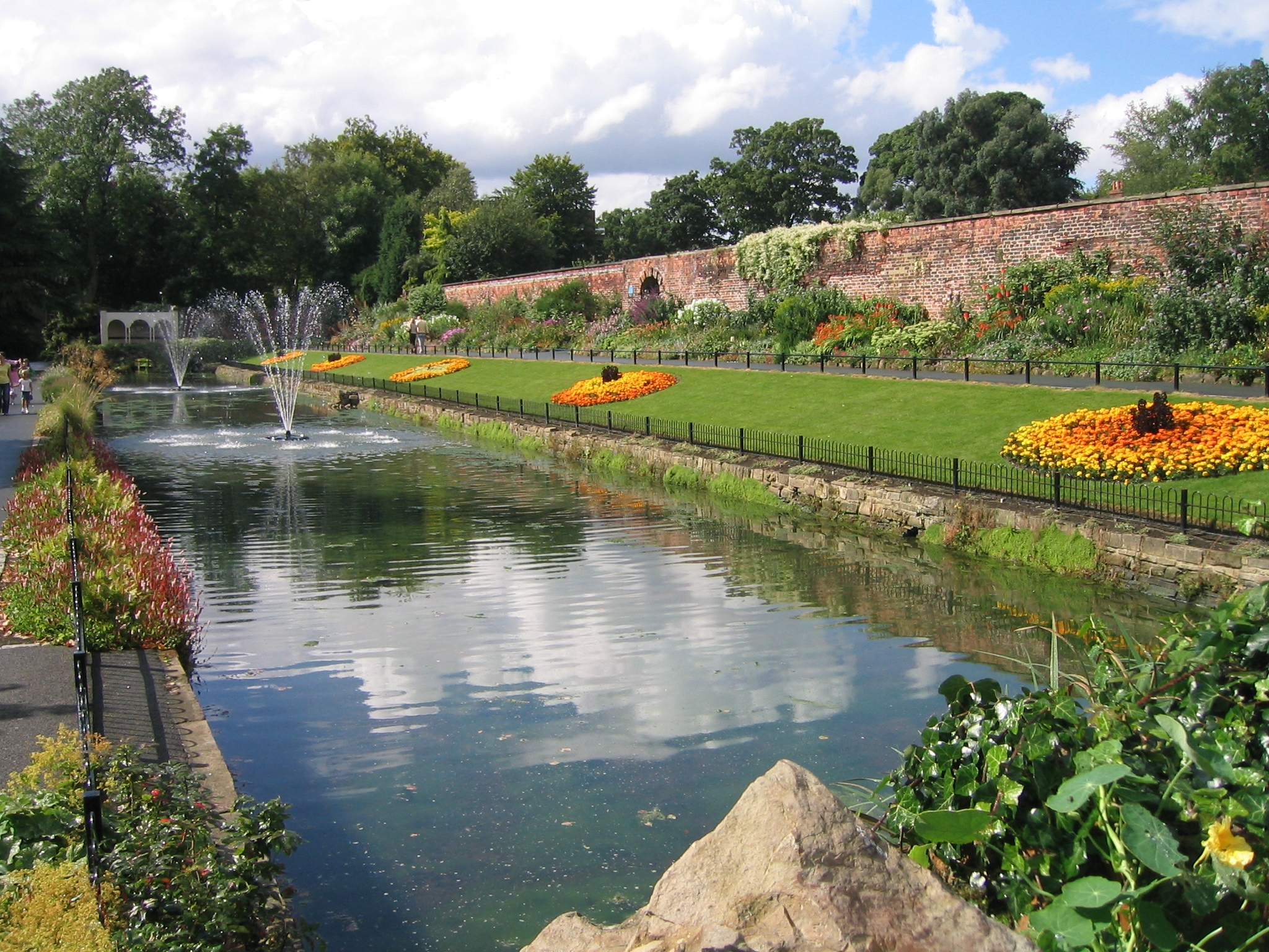
Oakwood is home to a range of amenities including shops, restaurants, and cafes, making it a vibrant and convenient place to live. Roundhay Park, one of the largest urban parks in Europe, is also nearby, providing residents with ample green space for outdoor activities.

The suburb has a strong sense of community, with local events and activities organized throughout the year. The Oakwood Farmers' Market, held monthly, is a popular event where residents can purchase fresh produce and artisan goods.

Overall, Oakwood offers a desirable mix of urban convenience and suburban tranquility, making it a sought-after area to live in Yorkshire.

If you have any feedback on the listing, please let us know in the comments section below.

Oakwood Images

Images are sourced within 2km of 53.824151/-1.494086 or Grid Reference SE3336. Thanks to Geograph Open Source API. All images are credited.

Lidgett Lane and Lidgett Avenue junction This stone post is on the east side of Lidgett Lane, and at the junction with Lidgett Avenue. The stone faces west and the benchmark is cut about 1 foot from ground level.
Lidgett Lane and Lidgett Avenue junction
This stone post is on the east side of Lidgett Lane, and at the junction with Lidgett Avenue. The stone faces west and the benchmark is cut about 1 foot from ground level.
Lidgett Lane and Lidgett Avenue junction This stone post is on the east side of Lidgett Lane, and at the junction with Lidgett Avenue. The stone faces west and there is a benchmark cut about 1 foot from ground level.
Lidgett Lane and Lidgett Avenue junction
This stone post is on the east side of Lidgett Lane, and at the junction with Lidgett Avenue. The stone faces west and there is a benchmark cut about 1 foot from ground level.
The Lake, Gledhow Valley Woods, Leeds This was part of the landscaping of the Gledhow Hall parkland, but was altered in the 1950s to provide flood attenuation, hence the elaborate outlet weir and screens.  The bay and screen in this image puzzles me - is it an inlet or an outlet?
The Lake, Gledhow Valley Woods, Leeds
This was part of the landscaping of the Gledhow Hall parkland, but was altered in the 1950s to provide flood attenuation, hence the elaborate outlet weir and screens. The bay and screen in this image puzzles me - is it an inlet or an outlet?
"I'm not dead yet", Gledhow Valley Woods Oak leaves sprouting from a tree stump.
"I'm not dead yet", Gledhow Valley Woods
Oak leaves sprouting from a tree stump.
Path at the top of the valley slope, Gledhow Valley Woods, Leeds
Heritage Open Day at Gipton Spa Bath House, Leeds This was organised by the Friends of Gledhow Valley Woods. Refreshments were available and various items were on sale.
Heritage Open Day at Gipton Spa Bath House, Leeds
This was organised by the Friends of Gledhow Valley Woods. Refreshments were available and various items were on sale.
Entrance to Gipton Spa Bath House, Leeds The entrance is into a small room with a fireplace and a basin with spring water. There is a doorway into the bath, to the right. The bath is fed by a spring, and has moss on the bottom. An inscription gives the date 1671 for the building.
Entrance to Gipton Spa Bath House, Leeds
The entrance is into a small room with a fireplace and a basin with spring water. There is a doorway into the bath, to the right. The bath is fed by a spring, and has moss on the bottom. An inscription gives the date 1671 for the building.
Inscription in Gipton Spa Bath House, Leeds According to the listing details the inscription is: Hoc faecit Edwardus Waddington de Gleadhowe Annovae Domini 1671.
Inscription in Gipton Spa Bath House, Leeds
According to the listing details the inscription is: Hoc faecit Edwardus Waddington de Gleadhowe Annovae Domini 1671.
New Testament Church of God, Easterly Road The congregation was celebrating its 60th anniversary; according to Wikipedia <span class="nowrap"><a title="https://en.wikipedia.org/wiki/List_of_places_of_worship_in_the_City_of_Leeds" rel="nofollow ugc noopener" href="https://en.wikipedia.org/wiki/List_of_places_of_worship_in_the_City_of_Leeds">Link</a><img style="margin-left:2px;" alt="External link" title="External link - shift click to open in new window" src="https://s1.geograph.org.uk/img/external.png" width="10" height="10"/></span> it was built in 1927 as a Christian Scientist meeting room and the NTCG moved into the building in 1985.
New Testament Church of God, Easterly Road
The congregation was celebrating its 60th anniversary; according to Wikipedia LinkExternal link it was built in 1927 as a Christian Scientist meeting room and the NTCG moved into the building in 1985.
Plaque to R V Nelson The plaque is on a New Testament church <a href="https://www.geograph.org.uk/photo/6986365">SE3235 : New Testament Church of God, Easterly Road</a> and is a tribute to their former pastor.
Plaque to R V Nelson
The plaque is on a New Testament church SE3235 : New Testament Church of God, Easterly Road and is a tribute to their former pastor.
Ice cream van at Roundhay Park Always a popular treat.
Ice cream van at Roundhay Park
Always a popular treat.
Funfair at Roundhay Park A seasonal attraction rather than a permanent one.
Funfair at Roundhay Park
A seasonal attraction rather than a permanent one.
Skatepark at Roundhay Park See also <a href="https://www.geograph.org.uk/photo/3796849">SE3237 : Skate park</a>; there's a playground beyond.
Skatepark at Roundhay Park
See also SE3237 : Skate park; there's a playground beyond.
Ashley Road, Leeds
Ashley Road, Leeds
Potternewton gurdwara The building is the former Potternewton Park Mansion, seen here from the rear. 
Grade II listed (list entry 1256051).  It is now the Gurdwara Shri Guru Hargobind Sahib Ji, to give its full name, hence the tall orange flagpole.
Potternewton gurdwara
The building is the former Potternewton Park Mansion, seen here from the rear. Grade II listed (list entry 1256051). It is now the Gurdwara Shri Guru Hargobind Sahib Ji, to give its full name, hence the tall orange flagpole.
Potternewton Park Mansion The former industrialist's mansion, built in 1817 and seen here from the front facing into the park, is grade II listed (list entry 1256051).  According to another contributor it was bought by Leeds Corporation in 1900 and used as an art gallery, later as a college building. It is now the Gurdwara Shri Guru Hargobind Sahib Ji <a href="https://www.geograph.org.uk/photo/7071257">SE3136 : Potternewton gurdwara</a>.
Potternewton Park Mansion
The former industrialist's mansion, built in 1817 and seen here from the front facing into the park, is grade II listed (list entry 1256051). According to another contributor it was bought by Leeds Corporation in 1900 and used as an art gallery, later as a college building. It is now the Gurdwara Shri Guru Hargobind Sahib Ji SE3136 : Potternewton gurdwara.
Plaque on Potternewton Park Mansion The rather faded plaque notes the mansion's 19th century origins and says it is now a college building.  That use has in turn ceased and the building is a gurdwara. For context, see <a href="https://www.geograph.org.uk/photo/7071276">SE3136 : Potternewton Park Mansion</a>.
Plaque on Potternewton Park Mansion
The rather faded plaque notes the mansion's 19th century origins and says it is now a college building. That use has in turn ceased and the building is a gurdwara. For context, see SE3136 : Potternewton Park Mansion.
Bowling green in Potternewton Park One of three originally; one has now become a community orchard and the other possibly disused.
Bowling green in Potternewton Park
One of three originally; one has now become a community orchard and the other possibly disused.
Show me another place!

Oakwood is located at Grid Ref: SE3336 (Lat: 53.824151, Lng: -1.494086)

Division: West Riding

Unitary Authority: Leeds

Police Authority: West Yorkshire

What 3 Words

///honest.submit.moved. Near Chapel Allerton, West Yorkshire

Nearby Locations

Hollin Park Oakwood

Related Wikis

Roundhay Garden Scene

Roundhay Garden Scene is a short silent motion picture filmed by French inventor Louis Le Prince at Oakwood Grange in Roundhay, Leeds, in Northern England...

Oakwood, Leeds

Oakwood is a suburb of north-east Leeds, West Yorkshire, England, that lies between Gipton and Roundhay Park. The suburb lies within the LS8 postcode and...

Roundhay

Roundhay is a large suburb in north-east Leeds, West Yorkshire, England. Roundhay had a population of 22,546 in 2011.It sits in the Roundhay ward of Leeds...

Fearnville

Fearnville is a small area of Leeds which has boundaries with Roundhay, Seacroft, Oakwood, Gipton and Harehills. Fearnville is commonly described as being...

Nearby Amenities

Located within 500m of 53.824151,-1.494086
Bus Stop
Easterly Road Hollin Park Mount
Bus: yes
Local Ref: 45011022
Naptan AtcoCode: 450011022
Naptan Bearing: SW
Naptan CommonName: Easterly Road Hollin Park Mount
Naptan Crossing: Hollin Park Mount
Naptan Indicator: Stop 45011022
Naptan PlusbusZoneRef: LEEDS
Naptan ShortCommonName: Hollin Park Mount
Naptan Street: Easterly Road
Naptan Verified: no
Public Transport: platform
Source: naptan_import
Lat/Long: 53.8222326/-1.4918752
Bus Stop
McDonalds Oakwood
Bus: yes
Local Ref: 45011023
Naptan AtcoCode: 450011023
Naptan Bearing: NE
Naptan CommonName: McDonalds Oakwood
Naptan Crossing: Oakwood Lane
Naptan Indicator: Stop 45011023
Naptan PlusbusZoneRef: LEEDS
Naptan ShortCommonName: Oakwood Lane
Naptan Street: Easterly Road
Naptan Verified: no
Public Transport: platform
Shelter: yes
Source: naptan_import
Lat/Long: 53.8208353/-1.4963035
Bus Stop
Oakwood Lane Oakwood Park
Bus: yes
Local Ref: 45013919
Naptan AtcoCode: 450013919
Naptan Bearing: SE
Naptan CommonName: Oakwood Lane Oakwood Park
Naptan Crossing: Oakwood Park
Naptan Indicator: Stop 45013919
Naptan PlusbusZoneRef: LEEDS
Naptan ShortCommonName: Oakwood Park
Naptan Street: Oakwood Lane
Naptan Verified: no
Public Transport: platform
Source: naptan_import
Lat/Long: 53.8235282/-1.4986046
Bus Stop
Oakwood Lane Montagu Crescent
Bus: yes
Local Ref: 45013920
Naptan AtcoCode: 450013920
Naptan Bearing: NW
Naptan CommonName: Oakwood Lane Montagu Crescent
Naptan Crossing: Montagu Crescent
Naptan Indicator: Stop 45013920
Naptan PlusbusZoneRef: LEEDS
Naptan ShortCommonName: Montagu Crescent
Naptan Street: Oakwood Lane
Naptan Verified: no
Public Transport: platform
Source: naptan_import
Lat/Long: 53.8235651/-1.4988169
Bus Stop
Oakwood Lane Montagu Crescent
Bus: yes
Local Ref: 45013921
Naptan AtcoCode: 450013921
Naptan Bearing: NW
Naptan CommonName: Oakwood Lane Montagu Crescent
Naptan Crossing: Montagu Crescent
Naptan Indicator: Stop 45013921
Naptan PlusbusZoneRef: LEEDS
Naptan ShortCommonName: Montagu Crescent
Naptan Street: Oakwood Lane
Naptan Verified: no
Public Transport: platform
Source: naptan_import
Lat/Long: 53.8218466/-1.4962701
Bus Stop
Oakwood Lane Hollin Park Road
Bus: yes
Local Ref: 45013922
Naptan AtcoCode: 450013922
Naptan Bearing: SE
Naptan CommonName: Oakwood Lane Hollin Park Road
Naptan Crossing: Hollin Park Road
Naptan Indicator: Stop 45013922
Naptan Landmark: Doctors Surgery
Naptan PlusbusZoneRef: LEEDS
Naptan ShortCommonName: Hollin Park Road
Naptan Street: Oakwood Lane
Naptan Verified: no
Public Transport: platform
Source: naptan_import
Lat/Long: 53.8207961/-1.4943839
Bus Stop
Fearnville Dib Lane
Bus: yes
Local Ref: 45013932
Naptan AtcoCode: 450013932
Naptan Bearing: SW
Naptan CommonName: Fearnville Dib Lane
Naptan Crossing: Dib Lane
Naptan Indicator: Stop 45013932
Naptan Notes: New Trueform shelter to be install 01/10/08
Naptan PlusbusZoneRef: LEEDS
Naptan ShortCommonName: Dib Lane
Naptan Street: Easterly Road
Naptan Verified: no
Public Transport: platform
Shelter: yes
Source: naptan_import
Lat/Long: 53.8237572/-1.4868587
Bus Stop
Easterly Road Hollin Park Mount
Bus: yes
Local Ref: 45013938
Naptan AtcoCode: 450013938
Naptan Bearing: NE
Naptan CommonName: Easterly Road Hollin Park Mount
Naptan Crossing: Hollin Park Mount
Naptan Indicator: Stop 45013938
Naptan PlusbusZoneRef: LEEDS
Naptan ShortCommonName: Hollin Park Mount
Naptan Street: Easterly Road
Naptan Verified: no
Public Transport: platform
Shelter: no
Source: naptan_import
Lat/Long: 53.8226442/-1.4914449
Bus Stop
Fearnville Dib Lane
Bus: yes
Local Ref: 45013939
Naptan AtcoCode: 450013939
Naptan Bearing: NE
Naptan CommonName: Fearnville Dib Lane
Naptan Crossing: North Lane
Naptan Indicator: Stop 45013939
Naptan PlusbusZoneRef: LEEDS
Naptan ShortCommonName: North Ln Fearnville
Naptan Street: Easterly Road
Naptan Verified: no
Public Transport: platform
Source: naptan_import
Lat/Long: 53.823912/-1.4873278
Bus Stop
Dib Lane Fearnville Close
Bus: yes
Local Ref: 45013944
Naptan AtcoCode: 450013944
Naptan Bearing: NE
Naptan CommonName: Dib Lane Fearnville Close
Naptan Crossing: Fearnville Close
Naptan Indicator: Stop 45013944
Naptan PlusbusZoneRef: LEEDS
Naptan ShortCommonName: Fearnville Close
Naptan Street: Dib Lane
Naptan Verified: no
Public Transport: platform
Source: naptan_import
Lat/Long: 53.8206668/-1.489327
Bus Stop
Dib Lane Easterly Road
Bus: yes
Local Ref: 45013945
Naptan AtcoCode: 450013945
Naptan Bearing: SW
Naptan CommonName: Dib Lane Easterly Road
Naptan Crossing: Easterly Road
Naptan Indicator: Stop 45013945
Naptan Landmark: Parade of Shops
Naptan PlusbusZoneRef: LEEDS
Naptan ShortCommonName: Dib Lane Shops
Naptan Street: Dib Lane
Naptan Verified: no
Public Transport: platform
Source: naptan_import
Lat/Long: 53.82337/-1.4866963
Turning Circle
Lat/Long: 53.8262057/-1.4978446
Turning Circle
Lat/Long: 53.8266034/-1.498715
Turning Circle
Lat/Long: 53.8263648/-1.4940259
Turning Circle
Lat/Long: 53.8232986/-1.4912893
Turning Circle
Lat/Long: 53.8258849/-1.4919022
Turning Circle
Lat/Long: 53.8235041/-1.4931045
Turning Circle
Lat/Long: 53.8259748/-1.4963266
Turning Circle
Lat/Long: 53.8227537/-1.4930547
Turning Circle
Lat/Long: 53.8259423/-1.4985835
Turning Circle
Lat/Long: 53.8250237/-1.4944595
Turning Circle
Lat/Long: 53.8258357/-1.4949169
Turning Circle
Lat/Long: 53.8236689/-1.4906992
Turning Circle
Lat/Long: 53.8250959/-1.4917894
Turning Circle
Lat/Long: 53.824278/-1.4955964
Turning Circle
Lat/Long: 53.8255455/-1.5001126
Turning Circle
Lat/Long: 53.8252549/-1.4935383
Turning Circle
Lat/Long: 53.828302/-1.4934847
Turning Circle
Lat/Long: 53.8198427/-1.4948359
Turning Circle
Lat/Long: 53.8203697/-1.4954021
Turning Circle
Lat/Long: 53.8207578/-1.4913431
Turning Circle
Lat/Long: 53.8204538/-1.4924736
Fulton's Foods
Addr City: Leeds
Addr Housenumber: 112-112a
Addr Postcode: LS8 3AY
Addr Street: Dib Lane
Brand: Fulton's Foods
Brand Wikidata: Q6112633
Brand Wikipedia: en:Fulton's Foods
Fhrs Id: 322357
Shop: frozen_food
Lat/Long: 53.8229972/-1.4870279
Crossing
Crossing: marked
Crossing Island: no
Crossing Ref: pelican
Direction: both
Tactile Paving: yes
Traffic Signals: pedestrian_crossing
Lat/Long: 53.8208967/-1.4946606
Entrance: main
Lat/Long: 53.8209469/-1.4944643
Pharmacy
Boots
Addr City: Leeds
Addr Housenumber: 5
Addr Postcode: LS8 3AS
Addr Street: Hollin Park Parade
Addr Suburb: Roundhay
Brand: Boots
Brand Wikidata: Q6123139
Brand Wikipedia: en:Boots (company)
Fhrs Id: 322197
Healthcare: pharmacy
Lat/Long: 53.8208795/-1.495183
Pharmacy
Well Pharmacy
Addr City: Leeds
Addr Housenumber: 120
Addr Postcode: LS8 3AY
Addr Street: Dib Lane
Brand: Well Pharmacy
Brand Wikidata: Q7726524
Brand Wikipedia: en:Well Pharmacy
Healthcare: pharmacy
Website: https://finder.well.co.uk/store/leeds-dib-lane
Lat/Long: 53.8232585/-1.4866456
Turning Circle
Lat/Long: 53.8209064/-1.4988036
Give Way
Lat/Long: 53.8238858/-1.4865354
Turning Circle
Lat/Long: 53.8258005/-1.4888192
Post Box
Inscription: GR V
Operator: Royal Mail
Operator Wikidata: Q638098
Post Box Type: pillar
Ref: LS8 103
Royal Cypher: GR
Royal Cypher Wikidata: Q33102273
Lat/Long: 53.8201279/-1.4935863
Post Box
Operator: Royal Mail
Operator Wikidata: Q638098
Post Box Type: pillar
Ref: LS8 556
Royal Cypher: GR
Royal Cypher Wikidata: Q33102273
Lat/Long: 53.8239401/-1.4996003
Post Box
Brand: Royal Mail
Brand Wikidata: Q638098
Operator: Royal Mail
Operator Wikidata: Q638098
Post Box Type: pillar
Ref: LS8 126
Royal Cypher: EIIR
Royal Cypher Wikidata: Q33102113
Lat/Long: 53.8272744/-1.4933636
Crossing
Bicycle: yes
Crossing: traffic_signals
Crossing Ref: toucan
Foot: yes
Lit: yes
Tactile Paving: yes
Traffic Signals: pedestrian_crossing
Lat/Long: 53.8240117/-1.4868645
Crossing
Bicycle: yes
Crossing: traffic_signals
Crossing Ref: toucan
Foot: yes
Lit: yes
Tactile Paving: yes
Traffic Signals: pedestrian_crossing
Lat/Long: 53.8238656/-1.4866965
Pub
The Orchard
Addr City: Leeds
Addr Postcode: LS8 3HL
Addr Street: Dib Lane
Addr Suburb: Roundhay
Fhrs Id: 1061259
Lat/Long: 53.8220569/-1.4874639
Crossing
Crossing: traffic_signals
Crossing Ref: pelican
Lat/Long: 53.820969/-1.4961185
Fast Food
Greggs Outlet
Addr City: Leeds
Addr Housenumber: 1
Addr Postcode: LS8 3AS
Addr Street: Hollin Park Parade
Brand: Greggs
Brand Wikidata: Q3403981
Brand Wikipedia: en:Greggs
Contact Website: https://www.greggs.co.uk/shop-finder?shop-code=0286
Cuisine: sandwich;bakery
Fhrs Id: 319848
Shop: bakery
Takeaway: yes
Lat/Long: 53.8209253/-1.4955775
Hollin Park News
Addr City: Leeds
Addr Housenumber: 2
Addr Postcode: LS8 3AS
Addr Street: Hollin Park Parade
Shop: newsagent
Lat/Long: 53.8209158/-1.495489
Mini Roundabout
Lat/Long: 53.8216073/-1.4960802
Atm
Lat/Long: 53.8208116/-1.494899
Entrance: yes
Lat/Long: 53.8207873/-1.4948537
Turning Circle
Lat/Long: 53.8221528/-1.4949347
Pharmacy
Healthcare: pharmacy
Lat/Long: 53.820382/-1.4939827
Hollin Park
Is In: Leeds, West Yorkshire, United Kingdom
Place: neighbourhood
Lat/Long: 53.8210207/-1.4951625
Fast Food
New Dor Bo
Addr City: Leeds
Addr Housenumber: 242
Addr Postcode: LS8 3ES
Addr Street: Easterly Road
Addr Suburb: Gipton
Cuisine: chinese
Fhrs Id: 319741
Takeaway: yes
Lat/Long: 53.8206984/-1.496273
Fast Food
Raj Punjab Dhaba
Addr City: Leeds
Addr Housenumber: 244
Addr Postcode: LS8 3ES
Addr Street: Easterly Road
Addr Suburb: Gipton
Cuisine: indian
Fhrs Id: 1649514
Takeaway: yes
Lat/Long: 53.8207293/-1.4961818
Fast Food
Flying Tandoori And Pizza Beach
Addr City: Leeds
Addr Housenumber: 250
Addr Postcode: LS8 3ES
Addr Street: Easterly Road
Addr Suburb: Gipton
Cuisine: indian;pizza
Fhrs Id: 1246964
Takeaway: yes
Lat/Long: 53.8208251/-1.4958975
Cafe
Cafe Jazz And Restaurant
Addr City: Leeds
Addr Housenumber: 6
Addr Postcode: LS8 3AS
Addr Street: Hollin Park Parade
Addr Suburb: Roundhay
Fhrs Id: 322661
Lat/Long: 53.8208797/-1.4950888
Social Facility
Oakhaven Residential Home
Addr City: Leeds
Addr Housenumber: 213
Addr Postcode: LS8 2PE
Addr Street: Oakwood Lane
Addr Suburb: Roundhay
Fhrs Id: 1075897
Social Facility: nursing_home
Lat/Long: 53.8232499/-1.4973472
Social Facility
Oakwood Hall
Addr City: Leeds
Addr Postcode: LS8 2PE
Addr Street: Oakwood Grange Lane
Addr Suburb: Gledhow
Fhrs Id: 320015
Social Facility: nursing_home
Lat/Long: 53.825597/-1.4958465
Pub
Adrian Club and Institute
Addr City: Leeds
Addr Postcode: LS8 2NN
Addr Street: Belle Vue Avenue
Addr Suburb: Roundhay
Fhrs Id: 466906
Lat/Long: 53.8245062/-1.4883511
Give Way
Lat/Long: 53.8243373/-1.4916762
Give Way
Lat/Long: 53.8241502/-1.4865388
Bus Stop
Bus: yes
Public Transport: platform
Shelter: yes
Lat/Long: 53.8217277/-1.494501
Noexit: yes
Lat/Long: 53.8250599/-1.4867765
Crossing
Crossing: unmarked
Crossing Island: yes
Kerb: flush
Lit: yes
Tactile Paving: yes
Lat/Long: 53.823855/-1.4864945
Barrier: kerb
Kerb: raised
Lat/Long: 53.8199336/-1.4947551
Traffic Calming: island
Lat/Long: 53.8212535/-1.4966033
William Hill
Addr City: Leeds
Addr Housenumber: 118
Addr Postcode: LS8 3AY
Addr Street: Dib Lane
Brand: William Hill
Brand Wikidata: Q4053147
Brand Wikipedia: en:William Hill (bookmaker)
Fhrs Id: 466963
Shop: bookmaker
Lat/Long: 53.8232151/-1.4867029
Barrier: block
Lat/Long: 53.8246612/-1.4902845
Give Way
Lat/Long: 53.8240473/-1.4920332
Hughes Funeral Services
Shop: funeral_directors
Lat/Long: 53.8208972/-1.4953387
Dentist
Perfect Smile Clinic
Healthcare: dentist
Lat/Long: 53.8208565/-1.4957906
Pharmacy
Dispensing: yes
Healthcare: pharmacy
Lat/Long: 53.8201201/-1.4937032
Ladbrokes
Brand: Ladbrokes
Brand Wikidata: Q1799875
Brand Wikipedia: en:Ladbrokes Coral
Shop: bookmaker
Lat/Long: 53.8207699/-1.4960256
Shop: laundry
Lat/Long: 53.8206211/-1.4964765
Shop: interior_decoration
Lat/Long: 53.8205728/-1.4966212
Shop: tattoo
Lat/Long: 53.8205294/-1.4967988
Shop: hairdresser
Lat/Long: 53.8205142/-1.4968528
Bicycle Parking
Lat/Long: 53.8202105/-1.4937219
Waste Basket
Collection Times: Mo; Th
Ref UK Leedscc Bin: 2353
Lat/Long: 53.825117/-1.500696
Waste Basket
Collection Times: Mo; Th
Ref UK Leedscc Bin: 2355
Lat/Long: 53.821814/-1.496271
Waste Basket
Collection Times: Mo; Th
Ref UK Leedscc Bin: 958
Lat/Long: 53.820581/-1.498203
Waste Basket
Collection Times: Mo; Th
Ref UK Leedscc Bin: 957
Lat/Long: 53.821281/-1.496007
Waste Basket
Collection Times: Mo-Fr
Ref UK Leedscc Bin: 963
Lat/Long: 53.820418/-1.497631
Waste Basket
Collection Times: Mo-Fr
Ref UK Leedscc Bin: 962
Lat/Long: 53.820854/-1.496081
Waste Basket
Collection Times: Mo-Fr
Ref UK Leedscc Bin: 2366
Lat/Long: 53.820784/-1.494618
Waste Basket
Ref UK Leedscc Bin: 4593
Lat/Long: 53.820842/-1.494146
Waste Basket
Collection Times: Mo; Th
Ref UK Leedscc Bin: 2311
Lat/Long: 53.824049/-1.487299
Waste Basket
Ref UK Leedscc Bin: 3603
Lat/Long: 53.823757/-1.486927
Waste Basket
Ref UK Leedscc Bin: 911
Lat/Long: 53.823199/-1.486885
Waste Basket
Ref UK Leedscc Bin: 907
Lat/Long: 53.823051/-1.487018
Waste Basket
Ref UK Leedscc Bin: 4561
Lat/Long: 53.823359/-1.486691
Waste Basket
Ref UK Leedscc Bin: 908
Lat/Long: 53.822019/-1.488051
Cafe
Dib Lane Diner
Addr City: Leeds
Addr Housenumber: 114a
Addr Postcode: LS8 3AY
Addr Street: Dib Lane
Addr Suburb: Roundhay
Fhrs Id: 1250009
Lat/Long: 53.8230654/-1.4869201
Crossing
Crossing: marked
Lat/Long: 53.8277057/-1.496164
Parking
Access: private
Parking: surface
Lat/Long: 53.8253344/-1.4982765
Parking
Parking: surface
Lat/Long: 53.8246516/-1.4871528
Parking
Parking: surface
Lat/Long: 53.8246025/-1.4866664
Crossing
Crossing: marked
Lat/Long: 53.8212071/-1.4959594
Crossing
Lat/Long: 53.8212295/-1.4961417
The data included in this document is from www.openstreetmap.org. The data is made available under ODbL.

Have you been to Oakwood?

Leave your review of Oakwood below (or comments, questions and feedback).