North Muskham

Settlement in Nottinghamshire Newark and Sherwood

England

North Muskham

Arable land
Arable land Credit: N Chadwick

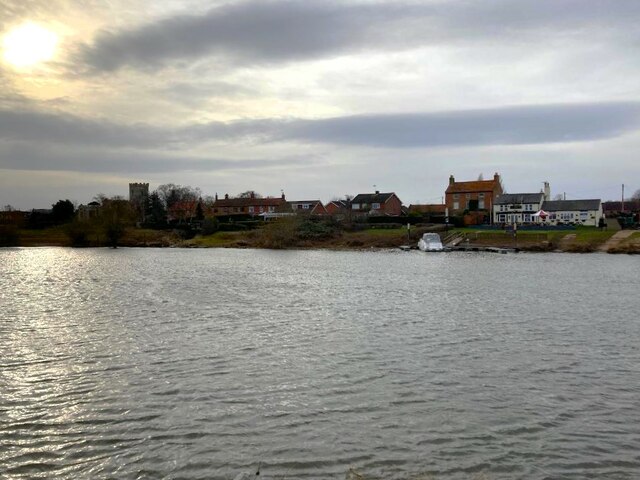
North Muskham is a small village located in the county of Nottinghamshire, England. It is situated on the eastern bank of the River Trent, approximately 3 miles north of the town of Newark-on-Trent. The village falls within the Newark and Sherwood district.

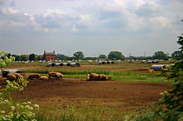
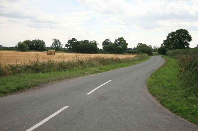
North Muskham is known for its picturesque rural setting, with open fields and farmland surrounding the village. It has a population of around 1,000 residents, making it a close-knit community with a strong sense of community spirit.

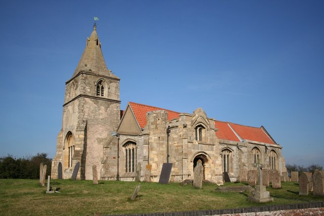
The village is home to a number of historic buildings, including the Grade II listed St. Wilfrid's Church, which dates back to the 12th century. The church is a prominent landmark and serves as a gathering place for religious services and community events.

In terms of amenities, North Muskham has a primary school, a village hall, and a pub called The Plough Inn, providing essential services and social spaces for residents. The village is also well-connected to nearby towns and cities, with good transport links and easy access to major roads.

Nature lovers can enjoy the beautiful countryside surrounding North Muskham, with opportunities for walking, cycling, and exploring the nearby Trent Valley Way. The village is also within close proximity to attractions such as Newark Castle and the National Civil War Centre, offering cultural and historical experiences for visitors.

Overall, North Muskham offers a peaceful and idyllic setting for residents and visitors alike, combining rural charm with easy access to amenities and nearby attractions.

If you have any feedback on the listing, please let us know in the comments section below.

North Muskham Images

Images are sourced within 2km of 53.120072/-0.810875 or Grid Reference SK7958. Thanks to Geograph Open Source API. All images are credited.

Arable land
Arable land
Winthorpe Rack (Track) Riverside track which is following a sharp bend of the River Trent as it progresses steadily north. Today was a mild January afternoon but another named storm (Isha) was moving in.
Winthorpe Rack (Track)
Riverside track which is following a sharp bend of the River Trent as it progresses steadily north. Today was a mild January afternoon but another named storm (Isha) was moving in.
Grassland by the River Trent Although the river can't be seen here there is a view from The Trent Valley Way (here) between Holme and North Muskham on the western bank where the tower of St Wilfrid's Church can be seen. The two communities were as one until a catastrophic flood on or around 1600 changed the river course and severed the two villages.
Grassland by the River Trent
Although the river can't be seen here there is a view from The Trent Valley Way (here) between Holme and North Muskham on the western bank where the tower of St Wilfrid's Church can be seen. The two communities were as one until a catastrophic flood on or around 1600 changed the river course and severed the two villages.
North Muskham seen from the East Bank of the Trent The Muskham Ferry pub and the Church of St Wilfrid can both be seen here.
North Muskham seen from the East Bank of the Trent
The Muskham Ferry pub and the Church of St Wilfrid can both be seen here.
Holme Village A fascinating village located in an isolated location near the River Trent.
Holme Village
A fascinating village located in an isolated location near the River Trent.
Winthorpe Rack (Track) With black German Shepherd sharing the riverside scenery.
Winthorpe Rack (Track)
With black German Shepherd sharing the riverside scenery.
Holme Lane Pictured from a spot just east of Holme village and looking in the direction of Langford Crossing.
Holme Lane
Pictured from a spot just east of Holme village and looking in the direction of Langford Crossing.
Field Bordering Holme Lane Flat field, perhaps being used for equestrian purposes,  pictured from the northern edge of the grid square.
Field Bordering Holme Lane
Flat field, perhaps being used for equestrian purposes, pictured from the northern edge of the grid square.
Free-range pig farming at North Muskham Information received from the farm manager (who lives in the house pictured):

This field is part of a 1000 sow breeding unit; the photo shows the good welfare standards good pig producers like to keep.
Free-range pig farming at North Muskham
Information received from the farm manager (who lives in the house pictured): This field is part of a 1000 sow breeding unit; the photo shows the good welfare standards good pig producers like to keep.
A1 Southbound crossing The Ness
Safe cycling An invaluable stretch of cycle path beside the A1, a safe corridor linking the country lanes on the west side of the River Trent
Safe cycling
An invaluable stretch of cycle path beside the A1, a safe corridor linking the country lanes on the west side of the River Trent
View nr Foxholes farm  The corn has been cut recently in the field on the left.
View nr Foxholes farm
The corn has been cut recently in the field on the left.
Flooded road near Holme Holme means island and at the moment it is almost that. The roads from Langford and Winthorpe are just dryish ribbons between flooded fields.
Flooded road near Holme
Holme means island and at the moment it is almost that. The roads from Langford and Winthorpe are just dryish ribbons between flooded fields.
Flooded fields near Holme
Flooded entrance to Bradwell's Field near Langford
Flooded fields off Holme Lane near Langford
St.Giles' church, Holme, Notts. Step back in time to a perfect unspoilt church thanks to a 15th century wool merchant and the location of Holme - on a road that leads only to the River Trent. There has been a church here since c1160 and the tower looks c1300, but it is the work paid for by wool merchant John Barton in c1485 that makes this church so important. Barton and his wife lie in a tomb showing them in life and below a 'memento mori' depicting an emaciated corpse ... a common fashion of the 15th century ! Medieval bench ends and window glass survive in a marvellous church.
St.Giles' church, Holme, Notts.
Step back in time to a perfect unspoilt church thanks to a 15th century wool merchant and the location of Holme - on a road that leads only to the River Trent. There has been a church here since c1160 and the tower looks c1300, but it is the work paid for by wool merchant John Barton in c1485 that makes this church so important. Barton and his wife lie in a tomb showing them in life and below a 'memento mori' depicting an emaciated corpse ... a common fashion of the 15th century ! Medieval bench ends and window glass survive in a marvellous church.
Nan Scott's Chamber Above the south porch of St.Giles' church is a room known as 'Nan Scott's chamber' - local legend says that Nan Scott sought refuge here during the great plague of 1666 and emerged to the outside world to find most of the village dead and buried.
Nan Scott's Chamber
Above the south porch of St.Giles' church is a room known as 'Nan Scott's chamber' - local legend says that Nan Scott sought refuge here during the great plague of 1666 and emerged to the outside world to find most of the village dead and buried.
Show me another place!

North Muskham is located at Grid Ref: SK7958 (Lat: 53.120072, Lng: -0.810875)

Administrative County: Nottinghamshire

District: Newark and Sherwood

Police Authority: Nottinghamshire

What 3 Words

///unearthly.link.stormy. Near South Collingham, Nottinghamshire

Related Wikis

St Wilfrid's Church, North Muskham

St. Wilfrid's Church, North Muskham is a parish church in the Church of England in North Muskham, Nottinghamshire. The church is Grade I listed by the...

North Muskham

North Muskham is a village and civil parish in Nottinghamshire, England, close to the border with Lincolnshire. It is located between the River Trent...

St Giles' Church, Holme

St Giles' Church, Holme is a Grade I listed parish church in the Church of England in Holme, Nottinghamshire. == History == The church dates from the 12th...

Holme, Nottinghamshire

Holme is a village and civil parish in Nottinghamshire, England. The population of the civil parish (including Langford) at the 2011 Census was 165. It...

Nearby Amenities

Located within 500m of 53.120072,-0.810875
North Muskham
Place: village
Source: NPE
Wikidata: Q7056170
Lat/Long: 53.1203222/-0.8109442
Created By: Merkaartor 0.12
Lat/Long: 53.1216569/-0.8120369
Created By: Merkaartor 0.12
Lat/Long: 53.1214258/-0.811918
Created By: Merkaartor 0.12
Lat/Long: 53.1219889/-0.812097
Bus Stop
Ferry Lane
Bus: yes
Naptan AtcoCode: 3300NS0143
Naptan Bearing: NW
Naptan CommonName: Ferry Lane
Naptan Crossing: Ferry Lane
Naptan Indicator: opp
Naptan Landmark: Muskham School
Naptan NaptanCode: ntsajmjd
Naptan Notes: BW
Naptan Street: Main Street
Naptan Verified: no
Public Transport: platform
Source: naptan_import
Lat/Long: 53.1199104/-0.8109028
Bus Stop
Chapel Lane
Bus: yes
Naptan AtcoCode: 3300NS0525
Naptan Bearing: S
Naptan CommonName: Chapel Lane
Naptan Crossing: Chapel Lane
Naptan Indicator: opp
Naptan Landmark: Post Office
Naptan NaptanCode: ntsagtwp
Naptan Notes: BW
Naptan Street: Main Street
Naptan Verified: no
Public Transport: platform
Source: naptan_import
Lat/Long: 53.1228698/-0.8119718
Bus Stop
Great North Road
Bus: yes
Naptan AtcoCode: 3300NS0673
Naptan Bearing: N
Naptan BusStopType: CUS
Naptan CommonName: Great North Road
Naptan Crossing: Bathley Lane
Naptan Indicator: N-bound
Naptan Landmark: Lord Nelson Inn
Naptan NaptanCode: ntsdjagd
Naptan Notes: CUS
Naptan Street: Great North Road
Naptan Verified: no
Public Transport: platform
Source: naptan_import
Lat/Long: 53.1198803/-0.8178073
Bus Stop
Great North Road
Bus: yes
Naptan AtcoCode: 3300NS0674
Naptan Bearing: S
Naptan BusStopType: CUS
Naptan CommonName: Great North Road
Naptan Crossing: Bathley Lane
Naptan Indicator: S-bound
Naptan Landmark: Lord Nelson Inn
Naptan NaptanCode: ntsdjagj
Naptan Notes: CUS
Naptan Street: Great North Road
Naptan Verified: no
Public Transport: platform
Source: naptan_import
Lat/Long: 53.1198606/-0.8176285
Chapel Lane
Naptan AtcoCode: 3300NS0834
Naptan Bearing: N
Naptan BusStopType: CUS
Naptan CommonName: Chapel Lane
Naptan Crossing: Chapel Lane
Naptan Indicator: adj
Naptan Landmark: Post Office
Naptan NaptanCode: ntsgmpjg
Naptan Notes: 3300NS0525
Naptan Street: Main Street
Naptan Verified: no
Source: naptan_import
Lat/Long: 53.1228082/-0.812108
Bus Stop
Nelson Lane
Bus: yes
Naptan AtcoCode: 3300NS0835
Naptan Bearing: E
Naptan BusStopType: CUS
Naptan CommonName: Nelson Lane
Naptan Crossing: Main Street
Naptan Indicator: E-bound
Naptan NaptanCode: ntsgmpjm
Naptan Notes: CUS
Naptan Street: Nelson Lane
Naptan Verified: no
Public Transport: platform
Source: naptan_import
Lat/Long: 53.1201772/-0.8115081
Bus Stop
Ferry Lane
Bus: yes
Naptan AtcoCode: 3300NS0836
Naptan Bearing: S
Naptan BusStopType: CUS
Naptan CommonName: Ferry Lane
Naptan Crossing: Ferry Lane
Naptan Indicator: adj
Naptan NaptanCode: ntsgmpjp
Naptan Notes: CUS--3300NS0143
Naptan Street: Main Street
Naptan Verified: no
Public Transport: platform
Source: naptan_import
Lat/Long: 53.1200169/-0.8107653
Bus Stop
Nelson Lane
Bus: yes
Naptan AtcoCode: 3300NS0925
Naptan Bearing: W
Naptan BusStopType: CUS
Naptan CommonName: Nelson Lane
Naptan Crossing: Main Street
Naptan Indicator: W-bound
Naptan NaptanCode: ntsgpmtp
Naptan Notes: CUS
Naptan Street: Nelson Lane
Naptan Verified: no
Public Transport: platform
Source: naptan_import
Lat/Long: 53.1201128/-0.8113604
Restaurant
Lat/Long: 53.1208322/-0.8177463
Post Box
Post Box Type: lamp
Ref: NG23 124
Royal Cypher: EIIR
Royal Cypher Wikidata: Q33102113
Lat/Long: 53.1230964/-0.8120092
Disused Amenity: post_box
Post Box Type: wall
Royal Cypher: GR
Lat/Long: 53.1230272/-0.8121942
Generator Method: photovoltaic
Generator Output Electricity: yes
Generator Source: solar
Generator Type: solar_photovoltaic_panel
Location: roof
Power: generator
Lat/Long: 53.116904/-0.809452
Generator Method: photovoltaic
Generator Output Electricity: yes
Generator Source: solar
Generator Type: solar_photovoltaic_panel
Location: roof
Power: generator
Lat/Long: 53.1178023/-0.8091194
Generator Method: photovoltaic
Generator Output Electricity: yes
Generator Source: solar
Generator Type: solar_photovoltaic_panel
Location: roof
Power: generator
Lat/Long: 53.1191062/-0.8101574
Generator Method: photovoltaic
Generator Output Electricity: yes
Generator Source: solar
Generator Type: solar_photovoltaic_panel
Location: roof
Power: generator
Lat/Long: 53.1197134/-0.8087841
Generator Method: photovoltaic
Generator Output Electricity: yes
Generator Source: solar
Generator Type: solar_photovoltaic_panel
Location: roof
Power: generator
Lat/Long: 53.1214772/-0.8122898
Generator Method: photovoltaic
Generator Output Electricity: yes
Generator Source: solar
Generator Type: solar_photovoltaic_panel
Location: roof
Power: generator
Lat/Long: 53.1215577/-0.8110238
Generator Method: photovoltaic
Generator Output Electricity: yes
Generator Source: solar
Generator Type: solar_photovoltaic_panel
Location: roof
Power: generator
Lat/Long: 53.1215577/-0.8100314
Generator Method: photovoltaic
Generator Output Electricity: yes
Generator Source: solar
Generator Type: solar_photovoltaic_panel
Location: roof
Power: generator
Lat/Long: 53.1215561/-0.8098704
Generator Method: photovoltaic
Generator Output Electricity: yes
Generator Source: solar
Generator Type: solar_photovoltaic_panel
Location: roof
Power: generator
Lat/Long: 53.1214627/-0.8092267
Generator Method: photovoltaic
Generator Output Electricity: yes
Generator Source: solar
Generator Type: solar_photovoltaic_panel
Location: roof
Power: generator
Lat/Long: 53.1216849/-0.8138401
Generator Method: photovoltaic
Generator Output Electricity: yes
Generator Source: solar
Generator Type: solar_photovoltaic_panel
Location: roof
Power: generator
Lat/Long: 53.1231866/-0.8152027
Generator Method: photovoltaic
Generator Output Electricity: yes
Generator Source: solar
Generator Type: solar_photovoltaic_panel
Location: roof
Power: generator
Lat/Long: 53.1233202/-0.8118553
Generator Method: photovoltaic
Generator Output Electricity: yes
Generator Source: solar
Generator Type: solar_photovoltaic_panel
Location: roof
Power: generator
Lat/Long: 53.1245178/-0.8112357
Generator Method: photovoltaic
Generator Output Electricity: yes
Generator Source: solar
Generator Type: solar_photovoltaic_panel
Location: roof
Power: generator
Lat/Long: 53.1244952/-0.8107395
The data included in this document is from www.openstreetmap.org. The data is made available under ODbL.

Have you been to North Muskham?

Leave your review of North Muskham below (or comments, questions and feedback).