Bethesda

Settlement in Pembrokeshire

Wales

Bethesda

St  Aidan's Church In a glorious position on the Eastern Cleddau down cliff from Llawhaden Castle.
St Aidan's Church Credit: Deborah Tilley

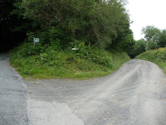
Bethesda is a small village located in the county of Pembrokeshire, Wales. Situated near the town of Narberth, Bethesda is known for its picturesque countryside and charming rural setting. The village is surrounded by rolling hills and lush green fields, making it a popular destination for those seeking a peaceful retreat.

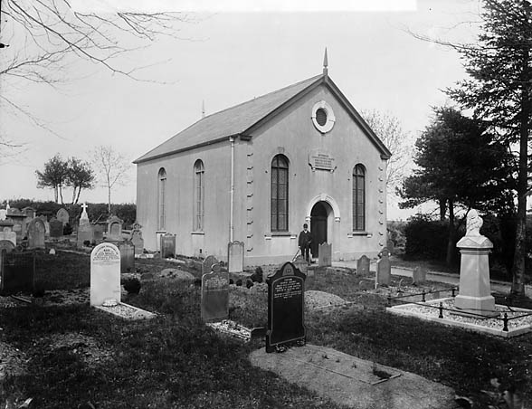
Bethesda has a rich history dating back to the medieval period, and there are several historic buildings and landmarks in the area, including the 12th-century St. Mary's Church. The village is also home to a number of traditional Welsh cottages and farmhouses, adding to its quaint and traditional feel.

In terms of amenities, Bethesda has a small convenience store, a pub, and a primary school, making it a self-sufficient community for its residents. The village is also well-connected to larger towns and cities in the area, with good transport links to nearby attractions such as the Pembrokeshire Coast National Park.

Overall, Bethesda is a charming and idyllic village that offers a peaceful and scenic setting for those looking to escape the hustle and bustle of city life.

If you have any feedback on the listing, please let us know in the comments section below.

Bethesda Images

Images are sourced within 2km of 51.829219/-4.772016 or Grid Reference SN0918. Thanks to Geograph Open Source API. All images are credited.

St  Aidan's Church In a glorious position on the Eastern Cleddau down cliff from Llawhaden Castle.
St Aidan's Church
In a glorious position on the Eastern Cleddau down cliff from Llawhaden Castle.
Directions to Holgan Camp Holgan Camp is a tapering oval enclosure, set upon a steep-sides, east-facing promontory, about110m east-west by 60m, delineated by double banks and ditches on the west, with an entrance at their southern limit, elsewhere defined by scarps above steep natural slopes. A limited excavation yielded radio-carbon dates indicating occupation in the 3rd-4th centuries BC.

Source: Williams & Mytum 1998 Llawhaden, Dyfed (BAR British ser. 275), 7, 69.

RCAHMW AP945092/42
Directions to Holgan Camp
Holgan Camp is a tapering oval enclosure, set upon a steep-sides, east-facing promontory, about110m east-west by 60m, delineated by double banks and ditches on the west, with an entrance at their southern limit, elsewhere defined by scarps above steep natural slopes. A limited excavation yielded radio-carbon dates indicating occupation in the 3rd-4th centuries BC. Source: Williams & Mytum 1998 Llawhaden, Dyfed (BAR British ser. 275), 7, 69. RCAHMW AP945092/42
View across the Eastern Cleddau Taken from the lane to Dan y Coed (Under the Trees).
View across the Eastern Cleddau
Taken from the lane to Dan y Coed (Under the Trees).
Rural Idyll Viewed from just above Holgan Fish Farm on the Eastern Cleddau.
Rural Idyll
Viewed from just above Holgan Fish Farm on the Eastern Cleddau.
View of castle, church and fishfarm A beautiful setting, near to many prehistoric settlements. This area has been inhabited for a very long time.
View of castle, church and fishfarm
A beautiful setting, near to many prehistoric settlements. This area has been inhabited for a very long time.
The remains of Llawhaden Castle gatehouse Impressive gatehouse which reveals the wealth and importance of the castle owners, the Bishop of St. Davids in the 14th century.
The remains of Llawhaden Castle gatehouse
Impressive gatehouse which reveals the wealth and importance of the castle owners, the Bishop of St. Davids in the 14th century.
Part of the ruins of Llawhaden Castle This section of walls and towers are part of the eastern range. A human figure stands on the stair landing for scale. This site should be more popular, but for its relative isolation and lack of awareness or promotion it would be.
Part of the ruins of Llawhaden Castle
This section of walls and towers are part of the eastern range. A human figure stands on the stair landing for scale. This site should be more popular, but for its relative isolation and lack of awareness or promotion it would be.
Part of the ruins of Llawhaden Castle The rear face of the ruined gatehouse stands on the right. The well sits in the centre of what would have been the courtyard.
Part of the ruins of Llawhaden Castle
The rear face of the ruined gatehouse stands on the right. The well sits in the centre of what would have been the courtyard.
Impressive remains of Llawhaden Castle Compared to many much better known castles Llawhaden still has much of its remains accessible and interpretable. A great day out.
Impressive remains of Llawhaden Castle
Compared to many much better known castles Llawhaden still has much of its remains accessible and interpretable. A great day out.
Part of the moat ditch at Llawhaden Castle I don't suppose that many visitors get access down there but they should. This castle seems to have it all; quiet site, large standing remains, easy access, tall towers, 'dungeons', a well, gatehouse, great outlook, interesting history, battlements, ditch or moat, stairs... I could go on.
Part of the moat ditch at Llawhaden Castle
I don't suppose that many visitors get access down there but they should. This castle seems to have it all; quiet site, large standing remains, easy access, tall towers, 'dungeons', a well, gatehouse, great outlook, interesting history, battlements, ditch or moat, stairs... I could go on.
Part of the undercroft at Llawhaden Castle This area at the ground level base of a tower or under the Great Hall was a central part of the castle where people would have cooked, served food, lived and worked.
Part of the undercroft at Llawhaden Castle
This area at the ground level base of a tower or under the Great Hall was a central part of the castle where people would have cooked, served food, lived and worked.
Arch of the undercroft at Llawhaden Castle The castle was abandoned by the Bishops of St. Davids following the Dissolution in 1536 and was gradually robbed out as a source of building stone for the nearby village or farms. The structure decayed, like all too many castles, over the centuries until only relatively recently we have taken them into public care and restored them to some semblance of their former selves. People lived and worked here for maybe two centuries.
Arch of the undercroft at Llawhaden Castle
The castle was abandoned by the Bishops of St. Davids following the Dissolution in 1536 and was gradually robbed out as a source of building stone for the nearby village or farms. The structure decayed, like all too many castles, over the centuries until only relatively recently we have taken them into public care and restored them to some semblance of their former selves. People lived and worked here for maybe two centuries.
View of the lane from Llawhaden Castle The lane here runs eastwards away from the valley of the Eastern Cleddau / Cleddau Ddu. Viewed from the tower of the castle.
View of the lane from Llawhaden Castle
The lane here runs eastwards away from the valley of the Eastern Cleddau / Cleddau Ddu. Viewed from the tower of the castle.
The vaulted ceiling in the tower at Llawhaden Castle This roof / ceiling still survives, from when it was installed in maybe 13-something. Say 1370. Quite something.
The vaulted ceiling in the tower at Llawhaden Castle
This roof / ceiling still survives, from when it was installed in maybe 13-something. Say 1370. Quite something.
Some of the ruins of Llawhaden Castle from the tower I love a castle that you can climb, via stairs.
Some of the ruins of Llawhaden Castle from the tower
I love a castle that you can climb, via stairs.
Part of the remains of Llawhaden Castle One of my favourite castles in Wales.
Part of the remains of Llawhaden Castle
One of my favourite castles in Wales.
The rear face of the gatehouse at Llawhaden Castle Only one tower remains, the other has long ago collapsed or been undermined to provide building stone following the Dissolution in the mid 1500's. Impressive survivor though. The site now managed by Cadw. Who I feel could well be missing a trick by not opening this site up (its near Oakwood and other attractions and may appeal to many people who I'm sure have yet to hear of it).
The rear face of the gatehouse at Llawhaden Castle
Only one tower remains, the other has long ago collapsed or been undermined to provide building stone following the Dissolution in the mid 1500's. Impressive survivor though. The site now managed by Cadw. Who I feel could well be missing a trick by not opening this site up (its near Oakwood and other attractions and may appeal to many people who I'm sure have yet to hear of it).
Track and bridleway to Dan-y-coed Farm The footpath follows the farm access track, along with the bridleway route, further into the valley of the Eastern Cleddau.
Track and bridleway to Dan-y-coed Farm
The footpath follows the farm access track, along with the bridleway route, further into the valley of the Eastern Cleddau.
Show me another place!

Bethesda is located at Grid Ref: SN0918 (Lat: 51.829219, Lng: -4.772016)

Unitary Authority: Pembrokeshire

Police Authority: Dyfed Powys

What 3 Words

///earl.banquets.riverbed. Near Narberth, Pembrokeshire

Nearby Locations

Bethesda

Related Wikis

Bethesda, Pembrokeshire

Bethesda (; Welsh: [bɛθ'ɛsda]) is a small village in the community of Llawhaden, Pembrokeshire, Wales. It lies on a bend of the B4313 road in the valley...
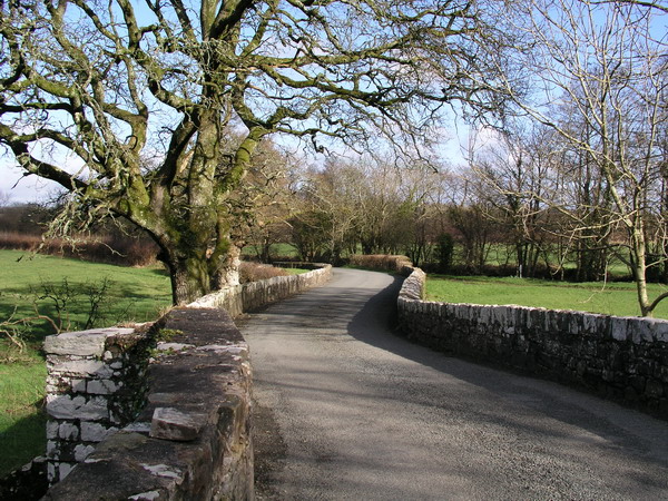
Gelli Bridge

Gelli Bridge is a Grade II listed two-arch bridge spanning the River Syfynwy a few yards before its confluence with the Eastern Cleddau. The date of the...

River Syfynwy

River Syfynwy (Welsh: Afon Syfynwy, Syfnwy or Syfni) is a river entirely within Pembrokeshire, Wales, rising in the Preseli Hills, feeding the Rosebush...

Gelli, Pembrokeshire

Gelli is a small settlement in the community and parish of Llawhaden, Pembrokeshire, Wales, at the confluence of the Syfynwy and Cleddau Ddu rivers. It...

Nearby Amenities

Located within 500m of 51.829219,-4.772016
Give Way
Direction: forward
Lat/Long: 51.8275697/-4.769895
Give Way
Direction: forward
Lat/Long: 51.8275664/-4.7701142
Bethesda
Place: hamlet
Lat/Long: 51.8276206/-4.77006
Direction: 170
Generator Method: photovoltaic
Generator Output Electricity: yes
Generator Solar Modules: 4
Generator Source: solar
Generator Type: solar_photovoltaic_panel
Location: roof
Power: generator
Lat/Long: 51.8277949/-4.7704157
Direction: SW
Generator Method: photovoltaic
Generator Output Electricity: yes
Generator Solar Modules: 16
Generator Source: solar
Generator Type: solar_photovoltaic_panel
Location: roof
Power: generator
Lat/Long: 51.826714/-4.7692147
Direction: 170
Generator Method: photovoltaic
Generator Output Electricity: yes
Generator Solar Modules: 8
Generator Source: solar
Generator Type: solar_photovoltaic_panel
Location: roof
Power: generator
Lat/Long: 51.8284248/-4.7709391
Direction: 170
Generator Method: photovoltaic
Generator Output Electricity: yes
Generator Solar Modules: 14
Generator Source: solar
Generator Type: solar_photovoltaic_panel
Location: roof
Power: generator
Lat/Long: 51.8284345/-4.7708341
Direction: 255
Generator Method: photovoltaic
Generator Output Electricity: yes
Generator Solar Modules: 9
Generator Source: solar
Generator Type: solar_photovoltaic_panel
Location: roof
Power: generator
Lat/Long: 51.8286162/-4.771047
Direction: 255
Generator Method: photovoltaic
Generator Output Electricity: yes
Generator Solar Modules: 9
Generator Source: solar
Generator Type: solar_photovoltaic_panel
Location: roof
Power: generator
Lat/Long: 51.8286229/-4.7710078
Direction: 165
Generator Method: photovoltaic
Generator Output Electricity: yes
Generator Solar Modules: 16
Generator Source: solar
Generator Type: solar_photovoltaic_panel
Location: roof
Power: generator
Lat/Long: 51.828075/-4.7695752
Direction: 170
Generator Method: photovoltaic
Generator Output Electricity: yes
Generator Solar Modules: 12
Generator Source: solar
Generator Type: solar_photovoltaic_panel
Location: roof
Power: generator
Lat/Long: 51.8277849/-4.7705287
Direction: SSE
Generator Method: photovoltaic
Generator Output Electricity: yes
Generator Solar Modules: 14
Generator Source: solar
Generator Type: solar_photovoltaic_panel
Location: roof
Power: generator
Lat/Long: 51.827702/-4.7700043
Direction: SE
Generator Method: photovoltaic
Generator Output Electricity: yes
Generator Solar Modules: 15
Generator Source: solar
Generator Type: solar_photovoltaic_panel
Location: roof
Power: generator
Lat/Long: 51.8269867/-4.7706534
The data included in this document is from www.openstreetmap.org. The data is made available under ODbL.

Have you been to Bethesda?

Leave your review of Bethesda below (or comments, questions and feedback).