Norman Cross

Settlement in Huntingdonshire Huntingdonshire

England

Norman Cross

A1(M), northbound The A1 is the longest numbered road in the UK at 410 miles long. It connects London with Edinburgh, via the east of England. 
For much of its path it follows the Great North Road the old coaching route between London and Edinburgh. Several sections of the route are classified as motorway A1(M). The modern A1 bypasses the towns the Great North Road passed through and is dual carriageway for most of its route through England.
A1(M), northbound Credit: N Chadwick

Norman Cross is a small village located in the county of Huntingdonshire, England. Situated approximately five miles northwest of the town of Peterborough, the village is well-known for its historical significance.

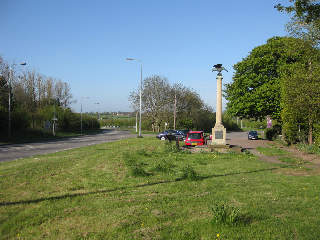
One of the notable features of Norman Cross is its former prisoner-of-war camp, which was operational during the Napoleonic Wars. Established in 1797, it was the first purpose-built camp of its kind in the world. The camp housed over 7,000 French prisoners, who were captured during the various conflicts of the time. Today, the site is marked by a memorial and a museum, providing visitors with a glimpse into the history of the camp and its impact on the local area.

The village itself is predominantly residential, with a population of around 600 people. It boasts a charming and picturesque setting, with a mix of traditional and modern architecture. The surrounding countryside offers beautiful views and opportunities for outdoor activities, such as hiking and cycling.

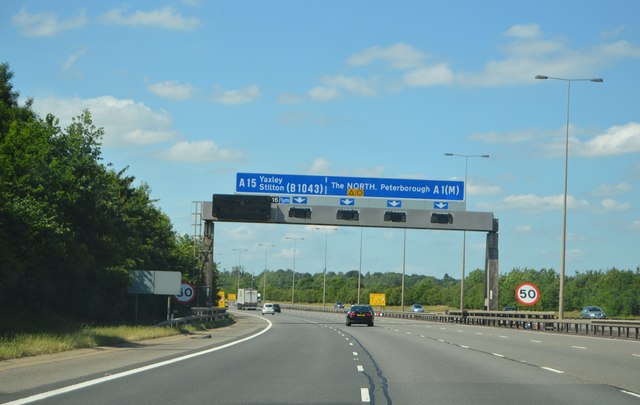
Norman Cross benefits from its proximity to Peterborough, which provides residents with access to a wider range of amenities, including shopping centers, restaurants, and cultural attractions. The village also benefits from good transport links, with the A1 road passing nearby, providing easy access to other parts of the country.

Overall, Norman Cross is a small but historically significant village that offers a peaceful and idyllic setting for its residents, while also attracting visitors interested in its unique past.

If you have any feedback on the listing, please let us know in the comments section below.

Norman Cross Images

Images are sourced within 2km of 52.50264/-0.295046 or Grid Reference TL1590. Thanks to Geograph Open Source API. All images are credited.

A1(M), northbound The A1 is the longest numbered road in the UK at 410 miles long. It connects London with Edinburgh, via the east of England. 
For much of its path it follows the Great North Road the old coaching route between London and Edinburgh. Several sections of the route are classified as motorway A1(M). The modern A1 bypasses the towns the Great North Road passed through and is dual carriageway for most of its route through England.
A1(M), northbound
The A1 is the longest numbered road in the UK at 410 miles long. It connects London with Edinburgh, via the east of England. For much of its path it follows the Great North Road the old coaching route between London and Edinburgh. Several sections of the route are classified as motorway A1(M). The modern A1 bypasses the towns the Great North Road passed through and is dual carriageway for most of its route through England.
A1(M) approaching J16 The A1 is the longest numbered road in the UK at 410 miles long. It connects London with Edinburgh, via the east of England. 
For much of its path it follows the Great North Road the old coaching route between London and Edinburgh. Several sections of the route are classified as motorway A1(M). The modern A1 bypasses the towns the Great North Road passed through and is dual carriageway for most of its route through England.
A1(M) approaching J16
The A1 is the longest numbered road in the UK at 410 miles long. It connects London with Edinburgh, via the east of England. For much of its path it follows the Great North Road the old coaching route between London and Edinburgh. Several sections of the route are classified as motorway A1(M). The modern A1 bypasses the towns the Great North Road passed through and is dual carriageway for most of its route through England.
Fen Lane from the corner with the old A1
Path towards Caldecote Dyke Farm
Towards Fen Drove
Towards Fen Drove
Towards Fen Drove
Towards Fen Drove
Fen Drove view
Fen Drove view
Fen Drove
Fen Drove
Fen Drove north-eastwards
Fen Drove south-westwards
Footpath crossing Fen Lane A meandering footpath crosses Fen Lane.
Footpath crossing Fen Lane
A meandering footpath crosses Fen Lane.
North Street, Stilton At the junction with Mill Road
North Street, Stilton
At the junction with Mill Road
Mill Road sign On Mill Road at the junction with North Street
Mill Road sign
On Mill Road at the junction with North Street
Mill Road, Stilton At the junction with North Street
Mill Road, Stilton
At the junction with North Street
North Street & Stilton Village Sign At the junction with Mill Road
North Street & Stilton Village Sign
At the junction with Mill Road
Stilton Village sign on North Street At the junction with Mill Road
Stilton Village sign on North Street
At the junction with Mill Road
Stilton Village sign on North Street At the junction with Mill Road
(Close up)
Stilton Village sign on North Street
At the junction with Mill Road (Close up)
Show me another place!

Norman Cross is located at Grid Ref: TL1590 (Lat: 52.50264, Lng: -0.295046)

Administrative County: Cambridgeshire

District: Huntingdonshire

Police Authority: Cambridgeshire

What 3 Words

///jaundice.humidity.workbench. Near Stilton, Cambridgeshire

Nearby Locations

Norman Cross

Related Wikis

Norman Cross Rural District

Norman Cross was a rural district in Huntingdonshire from 1894 to 1974. It was formed in 1894 under the Local Government Act 1894 from the part of the...

Norman Cross, Cambridgeshire

Norman Cross is a hamlet in the Huntingdonshire district of Cambridgeshire, England. It lies south of Peterborough, between the villages of Folksworth...

Norman Cross Prison

Norman Cross Prison in Huntingdonshire, England, was the world's first purpose-built prisoner-of-war camp or "depot". Constructed in 1796–97, it was designed...

Stilton

Stilton is a village and civil parish in Cambridgeshire, England, about 12 miles (19 km) north of Huntingdon in Huntingdonshire, which is a non-metropolitan...

Nearby Amenities

Located within 500m of 52.50264,-0.295046
Phone
Check Date: 2021-08-13
Emergency: phone
Lat/Long: 52.5023472/-0.2939458
Phone
Check Date: 2021-08-13
Emergency: phone
Lat/Long: 52.5024433/-0.2932948
Bus Stop
Folksworth Road
Bench: no
Bus: yes
Naptan AtcoCode: 0500HFOLK002
Naptan Bearing: S
Naptan CommonName: Folksworth Road
Naptan Indicator: opp
Naptan Landmark: Folksworth Road
Naptan NaptanCode: cmbdpajd
Naptan ShortCommonName: Folksworth Road
Naptan Street: B1043
Naptan Verified: no
Public Transport: platform
Shelter: no
Source: naptan_import
Lat/Long: 52.5002067/-0.2943787
Bus Stop
Folksworth Road
Bus: yes
Naptan AtcoCode: 0500HFOLK003
Naptan Bearing: N
Naptan CommonName: Folksworth Road
Naptan Indicator: near
Naptan Landmark: Folksworth Road
Naptan NaptanCode: cmbdpajg
Naptan ShortCommonName: Folksworth Road
Naptan Street: B1043
Naptan Verified: no
Public Transport: platform
Source: naptan_import
Lat/Long: 52.5007527/-0.294829
Bus Stop
Motel - Norman Cross
Bench: no
Bus: yes
Naptan AtcoCode: 0500HYAXL007
Naptan Bearing: SW
Naptan CommonName: Motel
Naptan Indicator: opp
Naptan Landmark: Motel
Naptan NaptanCode: cmbdtmat
Naptan ShortCommonName: Motel
Naptan Street: London Road
Naptan Verified: no
Public Transport: platform
Shelter: no
Source: naptan_import
Lat/Long: 52.5041025/-0.2895719
Bus Stop
Motel - Norman Cross
Bench: no
Bus: yes
Naptan AtcoCode: 0500HYAXL028
Naptan Bearing: NE
Naptan CommonName: Motel
Naptan Indicator: near
Naptan Landmark: Motel
Naptan NaptanCode: cmbdtmjt
Naptan ShortCommonName: Motel
Naptan Street: London Road
Naptan Verified: no
Public Transport: platform
Shelter: no
Source: naptan_import
Lat/Long: 52.5043684/-0.289311
Power: pole
Lat/Long: 52.5001722/-0.2894376
Material: wood
Power: pole
Lat/Long: 52.4991991/-0.2908216
Power: pole
Lat/Long: 52.4991885/-0.297921
Power: pole
Lat/Long: 52.4989747/-0.2940212
Power: pole
Lat/Long: 52.4985224/-0.29625
Power: pole
Lat/Long: 52.4987461/-0.2951288
The data included in this document is from www.openstreetmap.org. The data is made available under ODbL.

Have you been to Norman Cross?

Leave your review of Norman Cross below (or comments, questions and feedback).