Hinksey, New

Settlement in Berkshire Oxford

England

Hinksey, New

A34 Southern By-Pass Road
A34 Southern By-Pass Road Credit: Colin Pyle

Hinksey is a small village located in the county of Berkshire, England. Situated in the southern part of the county, it lies approximately 5 miles southwest of the town of Reading. Hinksey is a part of the civil parish of Hinksey New, which also includes the neighboring village of North Hinksey.

The village boasts a picturesque setting, surrounded by rolling countryside and beautiful landscapes. It is predominantly a residential area, characterized by a mix of traditional cottages and modern houses. The population of Hinksey is relatively small, with close-knit community ties and a friendly atmosphere.

Hinksey benefits from its close proximity to the bustling town of Reading, which offers a range of amenities, including shops, supermarkets, restaurants, and entertainment options. The village itself has a few local amenities, such as a village hall and a primary school, providing essential services to its residents.

Nature lovers are drawn to Hinksey due to its natural beauty and tranquil surroundings. The village is in close proximity to the River Thames, providing opportunities for scenic walks and boating activities. Additionally, the nearby countryside offers ample opportunities for outdoor activities such as hiking, cycling, and horse riding.

Overall, Hinksey, New, Berkshire is a charming village that offers a peaceful and scenic living environment within easy reach of larger towns and cities. Its idyllic setting and community spirit make it an attractive place to live for those seeking a quieter lifestyle while still being connected to urban amenities.

If you have any feedback on the listing, please let us know in the comments section below.
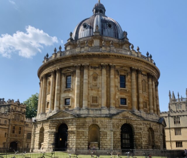
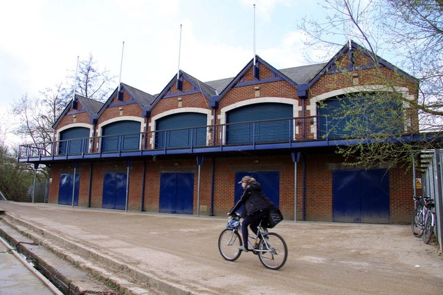
Hinksey, New Images

Images are sourced within 2km of 51.736767/-1.249816 or Grid Reference SP5104. Thanks to Geograph Open Source API. All images are credited.

A34 Southern By-Pass Road
The Radcliffe Camera, Oxford
E-scooter hire spot Two 'voi' e-scooters parked near Pembroke College in Oxford. There is another parking bay around the corner on Littlegate Street.
E-scooter hire spot
Two 'voi' e-scooters parked near Pembroke College in Oxford. There is another parking bay around the corner on Littlegate Street.
Gasworks Bridge This rather ornate bridge connects St Ebbes with Grandpont Nature Park and can be used by pedestrians and cyclists. The surroundings are quite peaceful now but this was once an industrial area - the bridge carrying a railway that served the St Ebbe's gasworks which extended to both sides of the river. It was built by the Oxford & District Gas Company in 1886 to bring coal from the Great Western Railway's main line to the works; it also allowed workers to cross on foot between the two sites. The works closed in 1960 and with it the railway (although two gas holders remained in use until 1968).
Gasworks Bridge
This rather ornate bridge connects St Ebbes with Grandpont Nature Park and can be used by pedestrians and cyclists. The surroundings are quite peaceful now but this was once an industrial area - the bridge carrying a railway that served the St Ebbe's gasworks which extended to both sides of the river. It was built by the Oxford & District Gas Company in 1886 to bring coal from the Great Western Railway's main line to the works; it also allowed workers to cross on foot between the two sites. The works closed in 1960 and with it the railway (although two gas holders remained in use until 1968).
Gasworks Bridge This bridge, and another pipe bridge a short distance downstream, are the only physical reminders of the St Ebbe's Gasworks that once occupied sites on both sides of the river. It was built in 1886 by the Oxford & District Gas Company to carry a private railway linking the Great Western Railway to the works. It is now used by pedestrians and cyclists.
Gasworks Bridge
This bridge, and another pipe bridge a short distance downstream, are the only physical reminders of the St Ebbe's Gasworks that once occupied sites on both sides of the river. It was built in 1886 by the Oxford & District Gas Company to carry a private railway linking the Great Western Railway to the works. It is now used by pedestrians and cyclists.
River Thames, Grandpont On the left is the Grandpont Nature park built on part of the old St Ebbe's gasworks site. In the background is Gasworks Bridge, built in 1886, which once carried a private railway serving the works but is now used by pedestrians and cyclists.
River Thames, Grandpont
On the left is the Grandpont Nature park built on part of the old St Ebbe's gasworks site. In the background is Gasworks Bridge, built in 1886, which once carried a private railway serving the works but is now used by pedestrians and cyclists.
River Thames, Grandpont Looking towards Folly Bridge which carries the A4144 across the River Thames (or Isis). Oxford has a confusing web of waterways and the buildings on the right are actually on an island with a smaller channel passing to the right. Until 1886 there was a weir in the main channel and a lock in the smaller one.
River Thames, Grandpont
Looking towards Folly Bridge which carries the A4144 across the River Thames (or Isis). Oxford has a confusing web of waterways and the buildings on the right are actually on an island with a smaller channel passing to the right. Until 1886 there was a weir in the main channel and a lock in the smaller one.
Caudwell's Castle One of Oxford's strangest buildings, Caudwell Castle, with its different window designs, stands on Folly Bridge Island overlooking one of the river channels just upstream from the bridge itself. It dates from 1849 when it was built for Joseph Caudwell, an eccentric Oxford accountant, who might have been inspired by the 'Folly Bridge' name. It is now divided into flats.
Caudwell's Castle
One of Oxford's strangest buildings, Caudwell Castle, with its different window designs, stands on Folly Bridge Island overlooking one of the river channels just upstream from the bridge itself. It dates from 1849 when it was built for Joseph Caudwell, an eccentric Oxford accountant, who might have been inspired by the 'Folly Bridge' name. It is now divided into flats.
Path to the River Thames This path leads off Abingdon Road to the river. A nearby notice states that it is owned by University College Oxford and 'the Council and those authorised by it are entitled to use it. The Council authorises members of the public to use it only on foot or on cycle during daylight hours. To the fullest extent permitted by law, the College accepts no responsibility for loss or damage arising from the use of the footpath'.
Path to the River Thames
This path leads off Abingdon Road to the river. A nearby notice states that it is owned by University College Oxford and 'the Council and those authorised by it are entitled to use it. The Council authorises members of the public to use it only on foot or on cycle during daylight hours. To the fullest extent permitted by law, the College accepts no responsibility for loss or damage arising from the use of the footpath'.
University boathouses by the River Thames There is a line of college boathouses on the island formed by two channels of the River Cherwell where it empties into the River Thames (or Isis). Although rowing at Oxford University can trace its origins back to the end of the 18th century, the first boathouse, combining a club room with boat storage facilities, did not appear until the late 1930s. Over the next two decades the others were gradually built - the last available space being taken in 1989. The boathouses come into their own during Eights Week in May or June when the balconies fill up with supporters cheering on the participants and imbibing copious quantities of drink.
University boathouses by the River Thames
There is a line of college boathouses on the island formed by two channels of the River Cherwell where it empties into the River Thames (or Isis). Although rowing at Oxford University can trace its origins back to the end of the 18th century, the first boathouse, combining a club room with boat storage facilities, did not appear until the late 1930s. Over the next two decades the others were gradually built - the last available space being taken in 1989. The boathouses come into their own during Eights Week in May or June when the balconies fill up with supporters cheering on the participants and imbibing copious quantities of drink.
Sculling on the Isis Passing swiftly and almost silently past the university boathouses, this was the only moving vessel on the water at the time.
Sculling on the Isis
Passing swiftly and almost silently past the university boathouses, this was the only moving vessel on the water at the time.
The mouth of the River Cherwell This is the point at which the River Cherwell, the second largest tributary of the Thames, ends its journey from near Hellidon in Northamptonshire, 40 miles away. To the left is the oldest of a long line of college boathouses.
The mouth of the River Cherwell
This is the point at which the River Cherwell, the second largest tributary of the Thames, ends its journey from near Hellidon in Northamptonshire, 40 miles away. To the left is the oldest of a long line of college boathouses.
Bridges over the Weirs Mill Stream These bridges carry the Thames path over the Weirs Mill Stream, a backwater of the river that by-passes Iffley Lock at Long Bridges. There was, until the 1980s, a public open air bathing place near here but pretty much all traces of it have gone.
Bridges over the Weirs Mill Stream
These bridges carry the Thames path over the Weirs Mill Stream, a backwater of the river that by-passes Iffley Lock at Long Bridges. There was, until the 1980s, a public open air bathing place near here but pretty much all traces of it have gone.
River Thames from Long Bridges This view is looking upstream from the bridge over the Weirs Mill Stream. The river looks suitably tranquil but there was no boating activity to be seen on this November weekday. In this vicinity the Thames has the alternative name 'Isis', generally favoured by the University rowing fraternity.
River Thames from Long Bridges
This view is looking upstream from the bridge over the Weirs Mill Stream. The river looks suitably tranquil but there was no boating activity to be seen on this November weekday. In this vicinity the Thames has the alternative name 'Isis', generally favoured by the University rowing fraternity.
Donnington Bridge Donnington Bridge was opened in 1962 linking Abingdon Road with Iffley Road. The road over it is part of the B4495.
Donnington Bridge
Donnington Bridge was opened in 1962 linking Abingdon Road with Iffley Road. The road over it is part of the B4495.
Under Donnington Bridge Donnington Bridge, spanning the River Thames (or Isis) dates from 1962 and was built to link Abingdon Road with Iffley Road in the southern suburbs of Oxford. Whether the design opposite can be described as a mural - or is merely graffiti - is a moot point.
Under Donnington Bridge
Donnington Bridge, spanning the River Thames (or Isis) dates from 1962 and was built to link Abingdon Road with Iffley Road in the southern suburbs of Oxford. Whether the design opposite can be described as a mural - or is merely graffiti - is a moot point.
Meadowland south of Weirs Lane  A herd of docile bullocks graze the land of what is in fact an island between the River Thames and Weirs Mill Stream. The path leads to the river.
Meadowland south of Weirs Lane
A herd of docile bullocks graze the land of what is in fact an island between the River Thames and Weirs Mill Stream. The path leads to the river.
Weirs Mill Stream Weirs Mill Stream is a backwater of the River Thames that avoids Iffley Lock, passing over a weir behind the photographer. A handful of narrowboats use this spot for a mooring.
Weirs Mill Stream
Weirs Mill Stream is a backwater of the River Thames that avoids Iffley Lock, passing over a weir behind the photographer. A handful of narrowboats use this spot for a mooring.
Show me another place!

Hinksey, New is located at Grid Ref: SP5104 (Lat: 51.736767, Lng: -1.249816)

Administrative County: Oxfordshire

District: Oxford

Police Authority: Thames Valley

What 3 Words

///towers.deeply.brands. Near Oxford, Oxfordshire

Nearby Locations

New Hinksey Hinksey, New

Related Wikis

Abingdon Road

Abingdon Road is the main arterial road to the south of the city of Oxford, England. The road passes through the suburbs of Grandpont and New Hinksey....

New Hinksey

New Hinksey is a suburb in the south of the city of Oxford. == Geography == The suburb is west of the Abingdon Road (A4144). To the north is Grandpont...

Hertford College Boat Club

Hertford College Boat Club (HCBC) is a rowing club for members of Hertford College, Oxford. It is based in the Longbridges boathouse on the Isis, which...

Wadham College Boat Club

Wadham College Boat Club (WCBC) is the rowing club of Wadham College, Oxford, in Oxford, United Kingdom. The club's members are students and staff from...

Nearby Amenities

Located within 500m of 51.736767,-1.249816
Traffic Signals
Source: local_knowledge
Lat/Long: 51.7341335/-1.250111
Crossing
Crossing: traffic_signals
Crossing Island: no
Crossing Ref: pelican
Tactile Paving: yes
Lat/Long: 51.7330106/-1.2493308
Turning Circle
Source: gps_survey;local_knowledge
Lat/Long: 51.733479/-1.2515241
New Hinksey
Place: quarter
Wikidata: Q7008645
Lat/Long: 51.7365567/-1.2533216
Barrier: cycle_barrier
Lat/Long: 51.7387967/-1.2560421
Turning Circle
Lat/Long: 51.7355232/-1.2474079
Turning Circle
Source: local_knowledge
Turning Circle: circle
Lat/Long: 51.7337221/-1.2484696
Barrier: bollard
Lat/Long: 51.7325026/-1.2502346
Waterway: weir
Lat/Long: 51.7343272/-1.2461878
Barrier: cattle_grid
Lat/Long: 51.7362568/-1.2446499
Barrier: cattle_grid
Lat/Long: 51.736382/-1.2446247
Note: point at which W.L. becomes D.B.R,
Source: photograph
Lat/Long: 51.734721/-1.2463256
Traffic Signals
Lat/Long: 51.7399071/-1.2536559
Traffic Signals
Lat/Long: 51.7370996/-1.251749
Crossing
Bicycle: yes
Crossing: traffic_signals
Crossing Ref: toucan
Lat/Long: 51.7350264/-1.250608
Barrier: cattle_grid
Lat/Long: 51.7347171/-1.2447767
Source: photograph
Lat/Long: 51.7350667/-1.247333
Barrier: bollard
Source: photograph
Lat/Long: 51.73399/-1.2502205
Created By: Merkaartor 0.13
Lat/Long: 51.7394203/-1.2442445
Created By: Merkaartor 0.13
Lat/Long: 51.7391213/-1.2441694
Created By: Merkaartor 0.13
Lat/Long: 51.7388622/-1.2440836
Barrier: bollard
Source: photograph
Lat/Long: 51.7350823/-1.2478355
Crossing
Crossing: unmarked
Crossing Island: no
Crossing Markings: no
Tactile Paving: yes
Traffic Calming: table
Lat/Long: 51.7348525/-1.2503748
Cycleway: asl
Direction: forward
Lat/Long: 51.7342733/-1.2501995
Barrier: bollard
Lat/Long: 51.7334469/-1.2513947
Barrier: cycle_barrier
Bicycle: yes
Cycle Barrier: tilted
Foot: yes
Lat/Long: 51.7373375/-1.2559778
Bus Stop
Chatham Road
Bench: yes
Bin: yes
Bus: yes
Covered: yes
Local Ref: opp
Naptan AtcoCode: 340000991OUT
Naptan Bearing: N
Naptan CommonName: Chatham Road
Naptan Indicator: Opposite
Naptan Landmark: Garage
Naptan NaptanCode: oxfadpwa
Naptan PlusbusZoneRef: OXFD
Naptan Street: Abingdon Road
Passenger Information Display: no
Public Transport: platform
Ref: 69323792
Route Ref: 46;34;35;NX1;X1;X2;X3;X32
Shelter: yes
Source: naptan_import
Lat/Long: 51.7347057/-1.2505406
Barrier: kissing_gate
Lat/Long: 51.7340814/-1.2452383
Bench
Lat/Long: 51.7363326/-1.2426308
Bench
Backrest: yes
Material: wood; metal
Seats: 3
Lat/Long: 51.7404849/-1.2478981
Bus Stop
Lake Street
Bench: no
Bin: no
Bus: yes
Covered: no
Naptan AtcoCode: 340000989OPP
Naptan Bearing: S
Naptan CommonName: Lake Street
Naptan Indicator: Opposite
Naptan Landmark: Berks Hs PH
Naptan NaptanCode: oxfadpwm
Naptan PlusbusZoneRef: OXFD
Naptan Street: Abingdon Road
Naptan Verified: no
Passenger Information Display: no
Public Transport: platform
Ref: 69323796
Route Ref: 46;43;35;NX1;X1;X2;X3;X32
Shelter: no
Source: naptan_import
Tactile Paving: no
Lat/Long: 51.7395392/-1.2533298
Bus Stop
Lincoln Road
Bench: yes
Bin: yes
Bus: yes
Covered: yes
Local Ref: adj
Naptan AtcoCode: 340000990CNR
Naptan Bearing: N
Naptan CommonName: Lincoln Road
Naptan Indicator: Corner
Naptan Landmark: Duke of Monmouth
Naptan NaptanCode: oxfadpwj
Naptan PlusbusZoneRef: OXFD
Naptan Street: Abingdon Road
Passenger Information Display: yes
Public Transport: platform
Ref: 69323795
Shelter: yes
Source: naptan_import
Tactile Paving: no
Lat/Long: 51.7373328/-1.2519669
Bus Stop
Lincoln Road
Bench: yes
Bin: no
Bus: yes
Covered: no
Local Ref: opp
Naptan AtcoCode: 340000990OPP
Naptan Bearing: S
Naptan CommonName: Lincoln Road
Naptan Indicator: Opposite
Naptan Landmark: Chip Shop
Naptan NaptanCode: oxfadpwg
Naptan PlusbusZoneRef: OXFD
Naptan Street: Abingdon Road
Passenger Information Display: no
Public Transport: platform
Ref: 69323794
Route Ref: 46;43;35;NX1;X1;X2;X3;X32
Shelter: no
Source: naptan_import
Lat/Long: 51.7367944/-1.2515503
Bus Stop
Chatham Road
Bench: no
Bin: yes
Covered: no
Direction: S
Naptan AtcoCode: 340000991CNR
Naptan Bearing: S
Naptan CommonName: Chatham Road
Naptan Indicator: Corner
Naptan Landmark: Chatham Road
Naptan NaptanCode: oxfadpwd
Naptan PlusbusZoneRef: OXFD
Naptan Street: Abingdon Road
Naptan Verified: no
Passenger Information Display: no
Public Transport: platform
Ref: 69323793
Route Ref: 46;43;35;NX1;X1;X2;X3;X32
Shelter: no
Source: naptan_import
Tactile Paving: no
Lat/Long: 51.7353695/-1.2507344
Bus Stop
Weirs Lane
Bus: yes
Naptan AtcoCode: 340001250CAN
Naptan Bearing: W
Naptan CommonName: Weirs Lane
Naptan Indicator: Westbound
Naptan Landmark: Weirs Lane
Naptan NaptanCode: oxfajdga
Naptan PlusbusZoneRef: OXFD
Naptan Street: Weirs Lane
Public Transport: platform
Route Ref: 12;16;16A
Shelter: no
Source: naptan_import
Lat/Long: 51.7343651/-1.2483452
Bus Stop
Weirs Lane
Bus: yes
Naptan AtcoCode: 340001250FOX
Naptan Bearing: E
Naptan CommonName: Weirs Lane
Naptan Indicator: Eastbound
Naptan Landmark: Weirs Lane
Naptan NaptanCode: oxfajdaw
Naptan PlusbusZoneRef: OXFD
Naptan Street: Weirs Lane
Public Transport: platform
Shelter: no
Source: naptan_import
Lat/Long: 51.7344103/-1.2489558
Bus Stop
Canning Crescent
Bus: yes
Naptan AtcoCode: 340001266OPP
Naptan Bearing: N
Naptan CommonName: Canning Crescent
Naptan Indicator: Opposite
Naptan Landmark: Canning Crescent
Naptan NaptanCode: oxfagwpa
Naptan PlusbusZoneRef: OXFD
Naptan Street: Abingdon Road
Public Transport: platform
Shelter: no
Source: naptan_import
Lat/Long: 51.7326362/-1.2492455
Bus Stop
Canning Crescent
Bench: yes
Bin: yes
Bus: yes
Lit: yes
Local Ref: o/s
Naptan AtcoCode: 340001266OUT
Naptan Bearing: S
Naptan CommonName: Canning Crescent
Naptan Indicator: Outside
Naptan Landmark: Canning Crescent
Naptan NaptanCode: oxfajamj
Naptan PlusbusZoneRef: OXFD
Naptan Street: Abingdon Road
Public Transport: platform
Ref: 69325265
Route Ref: 31;N31;34;35;44;200;N32;X2;X3;X13;X23;X32;X39;X40;X41
Shelter: no
Source: naptan_import
Tactile Paving: no
Lat/Long: 51.7328214/-1.2490649
Pharmacy
Bliep Chemists
Addr Housenumber: 190
Addr Postcode: OX1 4RA
Addr Street: Abingdon Road
Healthcare: pharmacy
Opening Hours: Mo-Fr 09:00-13:30,14:30-17:00
Phone: +44 1865 244468
Website: https://www.nhs.uk/Services/pharmacies/Overview/DefaultView.aspx?id=12850
Lat/Long: 51.7393493/-1.2534318
Akiport
Addr Housenumber: 194
Addr Street: Abingdon Road
Shop: convenience
Lat/Long: 51.7392683/-1.2533619
Addr City: Oxford
Addr Housenumber: 178-184
Addr Postcode: OX1 4RA
Addr Street: Abingdon Road
Disused Fhrs Id: 268326
Disused Name: Victoria Hotel
Disused Tourism: hotel
Lat/Long: 51.7395599/-1.2536104
Post Box
Collection Times: Mo-Fr 18:30; Sa 10:30
Ref: OX1 135
Lat/Long: 51.7325909/-1.248983
Operator: Network Rail
Railway: switch
Lat/Long: 51.7355495/-1.256653
Crossing
Crossing: uncontrolled
Lat/Long: 51.7348491/-1.2506115
Crossing
Crossing: unmarked
Crossing Island: yes
Crossing Markings: no
Tactile Paving: yes
Lat/Long: 51.7342497/-1.2501864
Crossing
Crossing: unmarked
Crossing Island: yes
Crossing Markings: no
Source: Bing
Tactile Paving: yes
Lat/Long: 51.7380102/-1.2522997
Crossing
Crossing: unmarked
Crossing Island: yes
Crossing Markings: no
Tactile Paving: yes
Lat/Long: 51.7360686/-1.2512044
Crossing
Crossing: unmarked
Crossing Island: yes
Crossing Markings: no
Tactile Paving: yes
Lat/Long: 51.7339892/-1.2500044
Crossing
Crossing: traffic_signals
Crossing Island: yes
Crossing Markings: no
Tactile Paving: yes
Lat/Long: 51.7341655/-1.2499284
Crossing
Crossing: uncontrolled
Crossing Markings: no
Lat/Long: 51.734592/-1.246778
Cold Harbour
Place: neighbourhood
Source: local knowledge
Lat/Long: 51.7343639/-1.2486907
Millstream Junction
Historic Railway: junction
Railway: site
Lat/Long: 51.7334787/-1.2546865
Post Box
Post Box Mounting: brick_pillar
Post Box Type: wall
Ref: OX1 134
Royal Cypher: EVIIR
Royal Cypher Wikidata: Q33102324
Source: Survey
Lat/Long: 51.7376071/-1.2521608
Addr Housenumber: 282a
Addr Postcode: OX1 4TE
Addr Street: Abingdon Road
Entrance: main
Lat/Long: 51.736158/-1.2514457
Entrance: service
Lat/Long: 51.7359352/-1.2519453
Entrance: yes
Lat/Long: 51.7359003/-1.2514479
Entrance: service
Lat/Long: 51.7360452/-1.2517293
Entrance: main
Lat/Long: 51.7347691/-1.2506927
Crossing
Crossing: uncontrolled
Crossing Ref: zebra
Lat/Long: 51.7344527/-1.2479823
Addr Housenumber: 272
Addr Postcode: OX1 4TA
Addr Street: Abingdon Road
Entrance: main
Lat/Long: 51.7366444/-1.25172
Addr Housenumber: 270
Addr Postcode: OX1 4TA
Addr Street: Abingdon Road
Entrance: main
Lat/Long: 51.7367208/-1.2517699
Addr Housenumber: 2
Addr Postcode: OX1 4TG
Addr Street: Northampton Road
Entrance: main
Lat/Long: 51.735421/-1.2516354
Addr Street: Abingdon Road
Entrance: main
Lat/Long: 51.7345538/-1.250579
Addr Housenumber: 282
Addr Postcode: OX1 4TA
Addr Street: Abingdon Road
Entrance: main
Lat/Long: 51.7362716/-1.2515991
Entrance: yes
Lat/Long: 51.7359401/-1.2513291
Addr Housenumber: 288
Addr Postcode: OX1 4TE
Addr Street: Abingdon Road
Entrance: main
Lat/Long: 51.735961/-1.251341
Addr Housenumber: 298
Addr Street: Abingdon Road
Entrance: yes
Lat/Long: 51.7356732/-1.2511891
Addr Flats: 1a
Addr Street: Lincoln Road
Entrance: main
Source: survey;bing
Lat/Long: 51.7365852/-1.2521217
Addr Flats: 1b
Addr Street: Lincoln Road
Entrance: main
Source: survey;bing
Lat/Long: 51.7366399/-1.2520794
Bicycle Parking
Bicycle Parking: stands
Capacity: 4
Lat/Long: 51.7366781/-1.2517141
Post Box
Check Date: 2021-11-30
Collection Times: Mo-Fr 18:30; Sa 11:30
Post Box Type: pillar
Ref: OX1 836
Royal Cypher: EIIR
Source: photograph
Lat/Long: 51.7351425/-1.2508222
Addr Flats: 1-2
Entrance: main
Lat/Long: 51.7367623/-1.2522907
Addr Flats: 1
Entrance: yes
Lat/Long: 51.7368791/-1.251821
Addr Flats: 2
Entrance: yes
Lat/Long: 51.7368142/-1.2519414
Entrance: main
Lat/Long: 51.7363532/-1.2547076
Entrance: yes
Lat/Long: 51.7363234/-1.254677
Addr Flats: 1
Lat/Long: 51.7375989/-1.2521895
Addr Flats: 2
Lat/Long: 51.7375521/-1.2522508
Oxford Dive Centre
Entrance: yes
Lat/Long: 51.7353264/-1.2512451
Car Sharing
Capacity: 1
Operator: Co-wheels Car Club
Website: https://www.co-wheels.org.uk/
Lat/Long: 51.7360731/-1.254431
Addr Flats: 1-4
Entrance: yes
Lat/Long: 51.7330537/-1.2490377
Entrance: yes
Lat/Long: 51.7330387/-1.2491055
Entrance: main
Lat/Long: 51.7362907/-1.2548501
Historic: milestone
Lat/Long: 51.7383916/-1.2451995
Barrier: block
Bicycle: yes
Foot: yes
Motor Vehicle: no
Lat/Long: 51.7351317/-1.2475204
Turning Circle
Lat/Long: 51.7404395/-1.2520591
Format: triangular prism
Height: 0.6
Historic: milestone
Inscription: TO OXFORD 1 MILE - TO ABINGDON 5 MILES
Lat/Long: 51.7326268/-1.2489936
Give Way
Lat/Long: 51.734471/-1.247609
Give Way
Lat/Long: 51.7345623/-1.2476369
Format: rectangular prism with rounded top
Height: 1.2
Historic: milestone
Lat/Long: 51.7380795/-1.2441894
Bench
Backrest: yes
Material: wood; metal
Seats: 3
Lat/Long: 51.7399083/-1.2473753
Cafe
Akiport
Addr City: Oxford
Addr Housenumber: 192
Addr Postcode: OX1 4RA
Addr Street: Abingdon Road
Cuisine: portuguese
Fhrs Id: 854386
Source Addr: FHRS Open Data
Lat/Long: 51.7393128/-1.2534001
Atm
Operator: Tesco
Lat/Long: 51.7339353/-1.2497227
Barrier: bollard
Bollard: fixed
Lat/Long: 51.7329225/-1.2490208
Addr Housenumber: 1
Addr Street: Leander Way
Entrance: yes
Lat/Long: 51.732583/-1.2473057
Addr Housenumber: 3
Addr Street: Leander Way
Entrance: yes
Lat/Long: 51.7326159/-1.247315
Addr Housenumber: 5
Addr Street: Leander Way
Entrance: yes
Lat/Long: 51.7326697/-1.2473301
Addr Housenumber: 7
Addr Street: Leander Way
Entrance: yes
Lat/Long: 51.7327023/-1.2473393
Addr Housenumber: 9
Addr Street: Leander Way
Entrance: yes
Lat/Long: 51.7327605/-1.2473556
Addr Housenumber: 11
Addr Street: Leander Way
Entrance: yes
Lat/Long: 51.7327893/-1.2473638
Addr Housenumber: 13
Addr Street: Leander Way
Entrance: yes
Lat/Long: 51.7328495/-1.2473807
Note: There is no number 13
Lat/Long: 51.7328208/-1.2473726
Addr Housenumber: 1
Addr Street: Isis Close
Entrance: yes
Lat/Long: 51.7326116/-1.2476943
Addr Housenumber: 2
Addr Street: Isis Close
Entrance: yes
Lat/Long: 51.7326062/-1.2477468
Addr Housenumber: 3
Addr Street: Isis Close
Entrance: yes
Lat/Long: 51.7325962/-1.2478451
Addr Housenumber: 4
Addr Street: Isis Close
Entrance: yes
Lat/Long: 51.7325914/-1.2478917
Addr Housenumber: 5
Addr Street: Isis Close
Entrance: yes
Lat/Long: 51.7325817/-1.2479863
Addr Housenumber: 6
Addr Street: Isis Close
Entrance: yes
Lat/Long: 51.732574/-1.2480616
Addr Housenumber: 15
Addr Street: Gordon Woodward Way
Entrance: yes
Lat/Long: 51.7325645/-1.2481671
Addr Housenumber: 11
Addr Street: Gordon Woodward Way
Entrance: yes
Lat/Long: 51.7325575/-1.2482342
Addr Housenumber: 9
Addr Street: Gordon Woodward Way
Entrance: yes
Lat/Long: 51.7325487/-1.2483195
Addr Housenumber: 7
Addr Street: Gordon Woodward Way
Entrance: yes
Lat/Long: 51.7325429/-1.2483756
Addr Housenumber: 5
Addr Street: Gordon Woodward Way
Entrance: yes
Lat/Long: 51.7325354/-1.2484474
Addr Housenumber: 3
Addr Street: Gordon Woodward Way
Entrance: yes
Lat/Long: 51.7325272/-1.2485266
Addr Housenumber: 1
Addr Street: Gordon Woodward Way
Entrance: yes
Lat/Long: 51.7325218/-1.2485784
Bicycle Parking
Bicycle Parking: stands
Capacity: 12
Lat/Long: 51.7338996/-1.2497927
Long Bridges Bathing Place
Alt Name: Longbridges Bathing Place
Leisure: bathing_place
Swimming Pool: outdoor
Lat/Long: 51.7378319/-1.245215
Addr Housenumber: 65
Addr Street: Norreys Avenue
Lat/Long: 51.7370983/-1.2549761
Addr Housenumber: 1
Addr Street: Norreys Avenue
Lat/Long: 51.7378923/-1.2530047
Muntjac Point
Direction: 225
Tourism: viewpoint
Lat/Long: 51.7386291/-1.244373
Leisure: outdoor_seating
Operator: The Duke of Monmouth
Lat/Long: 51.7371762/-1.2522231
Turning Circle
Source: Bing
Lat/Long: 51.7324653/-1.2501923
Addr Flats: 3-4
Entrance: yes
Lat/Long: 51.7368673/-1.251989
Entrance: yes
Lat/Long: 51.7368199/-1.252304
Addr City: Oxford
Addr Housenumber: 21
Addr Street: Vicarage Lane
Lat/Long: 51.7383756/-1.2561938
Addr City: Oxford
Addr Housenumber: 18
Addr Street: Vicarage Lane
Lat/Long: 51.7385041/-1.2563599
Addr Housenumber: 16
Addr Street: Vicarage Lane
Lat/Long: 51.7385331/-1.256439
Addr Housenumber: 15
Addr Street: Vicarage Lane
Lat/Long: 51.7385658/-1.2564767
Addr Housenumber: 43
Addr Street: Vicarage Road
Lat/Long: 51.7379405/-1.2555243
Addr City: Oxford
Addr Housenumber: 13
Addr Street: Vicarage Lane
Lat/Long: 51.7384411/-1.256523
Addr City: Oxford
Addr Housenumber: 1
Addr Street: Vicarage Lane
Lat/Long: 51.7380196/-1.2560076
Addr City: Oxford
Addr Housenumber: 32
Addr Street: Vicarage Road
Lat/Long: 51.7377659/-1.2561707
Addr City: Oxford
Addr Housenumber: 28
Addr Street: Vicarage Road
Lat/Long: 51.7378881/-1.2559069
Addr City: Oxford
Addr Housenumber: 72
Addr Street: Norreys Avenue
Lat/Long: 51.7372827/-1.2551679
Addr City: Oxford
Addr Housenumber: 2
Addr Street: Norreys Avenue
Lat/Long: 51.7381105/-1.2531014
SD Timmo Cars Sales
Shop: car
Website: https://www.sdtimmocarsales.co.uk/
Lat/Long: 51.7355829/-1.2511984
Charging Station
Capacity: 2
Lat/Long: 51.7360591/-1.2544113
Fast Food
Atlantic Fish Bar
Cuisine: fish_and_chips
Old Name: Mediterranean Fish Bar
Phone: +44 1865 243822
Takeaway: yes
Lat/Long: 51.7366955/-1.2518201
Leisure: picnic_table
Lat/Long: 51.7377392/-1.2447892
Addr City: Oxford
Addr Housenumber: 234
Addr Street: Abingdon Road
Lat/Long: 51.7382379/-1.2526658
Addr City: Oxford
Addr Housenumber: 202
Addr Street: Abingdon Road
Lat/Long: 51.7390094/-1.2532038
Direction: 170
Generator Method: photovoltaic
Generator Output Electricity: yes
Generator Solar Modules: 7
Generator Source: solar
Generator Type: solar_photovoltaic_panel
Location: roof
Power: generator
Lat/Long: 51.7335131/-1.2484284
Fixme: solar panels?
Lat/Long: 51.7384357/-1.2535589
Direction: 140
Generator Method: photovoltaic
Generator Output Electricity: yes
Generator Solar Modules: 8
Generator Source: solar
Generator Type: solar_photovoltaic_panel
Location: roof
Power: generator
Lat/Long: 51.7387599/-1.2536134
Direction: 145
Generator Method: photovoltaic
Generator Output Electricity: yes
Generator Solar Modules: 8
Generator Source: solar
Generator Type: solar_photovoltaic_panel
Location: roof
Power: generator
Lat/Long: 51.7373994/-1.2525826
Direction: 230
Generator Method: photovoltaic
Generator Output Electricity: yes
Generator Solar Modules: 16
Generator Source: solar
Generator Type: solar_photovoltaic_panel
Location: roof
Power: generator
Lat/Long: 51.7384853/-1.2558953
Fixme: solar panels?
Lat/Long: 51.7385379/-1.2564183
Fixme: solar panels?
Lat/Long: 51.7345329/-1.2511558
Crossing
Crossing: unmarked
Crossing Markings: no
Lat/Long: 51.7355083/-1.2509551
Crossing
Crossing: unmarked
Crossing Island: no
Crossing Markings: no
Tactile Paving: yes
Lat/Long: 51.7362336/-1.2513566
Crossing
Crossing: unmarked
Crossing Island: no
Crossing Markings: no
Lat/Long: 51.737511/-1.2520731
Telephone
Booth: KX100
Covered: booth
Operator: BT
Payment Coins: yes
Payment Debit Cards: yes
Lat/Long: 51.7350756/-1.2507463
Crossing
Lat/Long: 51.733532/-1.2495738
Addr City: Oxford
Addr Housenumber: 178
Addr Street: Abingdon Road
Lat/Long: 51.7396805/-1.2536871
Addr City: Oxford
Addr Housenumber: 176
Addr Street: Abingdon Road
Lat/Long: 51.7397133/-1.253717
Addr City: Oxford
Addr Housenumber: 170
Addr Street: Abingdon Road
Lat/Long: 51.7398867/-1.2538518
Addr City: Oxford
Addr Housenumber: 160
Addr Street: Abingdon Road
Lat/Long: 51.7400851/-1.2540044
Addr City: Oxford
Addr Housenumber: 1
Addr Street: Lake Street
Lat/Long: 51.7401173/-1.2540781
Addr City: Oxford
Addr Housenumber: 1
Addr Street: School Place
Lat/Long: 51.7384391/-1.2554389
Addr City: Oxford
Addr Housenumber: 8
Addr Street: School Place
Lat/Long: 51.7386312/-1.2556686
Addr City: Oxford
Addr Housenumber: 25
Addr Street: Vicarage Road
Lat/Long: 51.7382446/-1.2551895
Addr City: Oxford
Addr Housenumber: 19
Addr Street: Vicarage Road
Lat/Long: 51.7384197/-1.2548047
Addr City: Oxford
Addr Housenumber: 18a
Addr Street: Vicarage Road
Lat/Long: 51.7384488/-1.2547477
Addr City: Oxford
Addr Housenumber: 17
Addr Street: Vicarage Road
Lat/Long: 51.7385145/-1.2545965
Addr City: Oxford
Addr Housenumber: 8
Addr Street: Vicarage Road
Lat/Long: 51.7387188/-1.2541606
Addr City: Oxford
Addr Housenumber: 7
Addr Street: Vicarage Road
Lat/Long: 51.7387869/-1.2540114
Addr City: Oxford
Addr Housenumber: 1
Addr Street: Vicarage Road
Lat/Long: 51.7389425/-1.2536796
Addr City: Oxford
Addr Housenumber: 1a
Addr Street: Vicarage Road
Lat/Long: 51.7389692/-1.2536226
Addr City: Oxford
Addr Housenumber: 70
Addr Street: Vicarage Road
Lat/Long: 51.738803/-1.2536008
Addr City: Oxford
Addr Housenumber: 66
Addr Street: Vicarage Road
Lat/Long: 51.7386944/-1.2538322
Addr City: Oxford
Addr Housename: The Old Postoffice
Addr Housenumber: 1a
Addr Street: Green Place
Lat/Long: 51.7386267/-1.2537862
Addr City: Oxford
Addr Housenumber: 65
Addr Street: Vicarage Road
Lat/Long: 51.7386175/-1.2540255
Addr City: Oxford
Addr Housenumber: 64
Addr Street: Vicarage Road
Lat/Long: 51.7385981/-1.254072
Addr City: Oxford
Addr Housenumber: 55
Addr Street: Vicarage Road
Lat/Long: 51.7383371/-1.2544652
Addr City: Oxford
Addr Housenumber: 54
Addr Street: Vicarage Road
Lat/Long: 51.7383054/-1.2545491
Addr City: Oxford
Addr Housenumber: 53
Addr Street: Vicarage Road
Lat/Long: 51.7382393/-1.2546907
Addr City: Oxford
Addr Housenumber: 52
Addr Street: Vicarage Road
Lat/Long: 51.7382062/-1.2547593
Addr City: Oxford
Addr Housenumber: 51
Addr Street: Vicarage Road
Lat/Long: 51.7381725/-1.25495
Addr City: Oxford
Addr Housenumber: 50
Addr Street: Vicarage Road
Lat/Long: 51.7381199/-1.2550371
Addr City: Oxford
Addr Housenumber: 49a
Addr Street: Vicarage Road
Lat/Long: 51.7380969/-1.2551101
Addr City: Oxford
Addr Housenumber: 49
Addr Street: Vicarage Road
Lat/Long: 51.7380861/-1.2551439
Addr City: Oxford
Addr Housenumber: 48
Addr Street: Vicarage Road
Lat/Long: 51.738072/-1.255182
Addr City: Oxford
Addr Housenumber: 47
Addr Street: Vicarage Road
Lat/Long: 51.7380477/-1.2552582
Addr City: Oxford
Addr Housenumber: 46
Addr Street: Vicarage Road
Lat/Long: 51.7380301/-1.2553073
Addr City: Oxford
Addr Housenumber: 45
Addr Street: Vicarage Road
Lat/Long: 51.7379607/-1.2553323
Addr City: Oxford
Addr Housenumber: 44
Addr Street: Vicarage Road
Lat/Long: 51.7379296/-1.2554151
Addr City: Oxford
Addr Housenumber: 42
Addr Street: Vicarage Road
Lat/Long: 51.7379094/-1.2555894
Addr City: Oxford
Addr Housenumber: 19
Addr Street: Green Place
Lat/Long: 51.7380713/-1.2542738
Addr City: Oxford
Addr Housenumber: 21
Addr Street: Green Place
Lat/Long: 51.7380439/-1.2542473
Addr City: Oxford
Addr Housenumber: 15
Addr Street: Green Place
Lat/Long: 51.7382962/-1.2537937
Addr City: Oxford
Addr Housenumber: 17
Addr Street: Green Place
Lat/Long: 51.7382634/-1.2537593
Addr City: Oxford
Addr Housenumber: 2
Addr Street: Green Place
Lat/Long: 51.7384987/-1.2536405
Addr City: Oxford
Addr Housenumber: 12
Addr Street: Green Place
Lat/Long: 51.738357/-1.2534717
Addr City: Oxford
Addr Housenumber: 11
Addr Street: Green Place
Lat/Long: 51.7384425/-1.253808
Addr City: Oxford
Addr Housenumber: 9
Addr Street: Green Place
Lat/Long: 51.7384749/-1.2538475
Addr City: Oxford
Addr Housenumber: 5a
Addr Street: Green Place
Lat/Long: 51.738882/-1.2543468
Addr City: Oxford
Addr Housenumber: 5
Addr Street: Green Place
Lat/Long: 51.7389112/-1.2543722
Addr City: Oxford
Addr Housenumber: 3
Addr Street: Green Place
Lat/Long: 51.7389337/-1.2544024
Addr City: Oxford
Addr Housenumber: 1
Addr Street: Green Place
Lat/Long: 51.7389576/-1.2544326
Addr City: Oxford
Addr Housenumber: 1
Addr Street: Summerfield
Lat/Long: 51.7395459/-1.2546405
Addr City: Oxford
Addr Housenumber: 13
Addr Street: Summerfield
Lat/Long: 51.7390804/-1.2540797
Addr City: Oxford
Addr Housenumber: 14
Addr Street: Summerfield
Lat/Long: 51.7391051/-1.2544169
Addr City: Oxford
Addr Housenumber: 23
Addr Street: Summerfield
Lat/Long: 51.7394112/-1.2548001
Addr City: Oxford
Addr Housenumber: 59
Addr Street: Lake Street
Lat/Long: 51.7396988/-1.2552677
Addr City: Oxford
Addr Housenumber: 61
Addr Street: Lake Street
Lat/Long: 51.7397478/-1.2551578
Addr City: Oxford
Addr Housenumber: 61a
Addr Street: Lake Street
Lat/Long: 51.7397769/-1.2550987
Addr City: Oxford
Addr Housenumber: 61b
Addr Street: Lake Street
Lat/Long: 51.7398068/-1.255033
Addr City: Oxford
Addr Housenumber: 69
Addr Street: Lake Street
Lat/Long: 51.7400443/-1.254624
Addr City: Oxford
Addr Housenumber: 72
Addr Street: Lake Street
Lat/Long: 51.7401082/-1.2544792
Addr City: Oxford
Addr Housenumber: 9
Addr Street: Lake Street
Lat/Long: 51.7398674/-1.2545207
Addr City: Oxford
Addr Housenumber: 14
Addr Street: Lake Street
Lat/Long: 51.7397013/-1.2548748
Addr City: Oxford
Addr Housenumber: 15
Addr Street: Lake Street
Lat/Long: 51.7396234/-1.2550387
Addr City: Oxford
Addr Housenumber: 25
Addr Street: Lake Street
Lat/Long: 51.7393684/-1.2555677
Addr City: Oxford
Addr Housenumber: 26
Addr Street: Lake Street
Lat/Long: 51.7392824/-1.2557222
Addr City: Oxford
Addr Housenumber: 7
Addr Street: Gordon Street
Lat/Long: 51.7390785/-1.2552488
Addr City: Oxford
Addr Housenumber: 27
Addr Street: Gordon Street
Lat/Long: 51.7387318/-1.254791
Addr City: Oxford
Addr Housenumber: 16
Addr Street: Gordon Street
Lat/Long: 51.7388405/-1.2552105
Addr City: Oxford
Addr Housenumber: 4
Addr Street: Gordon Street
Lat/Long: 51.7390449/-1.2554545
Addr City: Oxford
Addr Flats: ;a;b
Addr Housenumber: 10
Addr Street: Gordon Street
Lat/Long: 51.7389311/-1.2553187
Addr City: Oxford
Addr Housenumber: 2
Addr Street: Stewart Street
Lat/Long: 51.7390625/-1.2556604
Addr City: Oxford
Addr Housenumber: 2a
Addr Street: Stewart Street
Lat/Long: 51.7390391/-1.2557228
Addr City: Oxford
Addr Housenumber: 5
Addr Street: Stewart Street
Lat/Long: 51.7387436/-1.2560654
Addr City: Oxford
Addr Housenumber: 10
Addr Street: Stewart Street
Lat/Long: 51.738879/-1.2557799
Bench
Lat/Long: 51.7348548/-1.2454832
Crossing
Crossing: uncontrolled
Crossing Markings: no
Lat/Long: 51.7346383/-1.2476628
Crossing
Crossing: uncontrolled
Crossing Markings: no
Lat/Long: 51.7343544/-1.2475643
Crossing
Crossing: uncontrolled
Lat/Long: 51.7343068/-1.2486792
Stop
Direction: forward
Lat/Long: 51.7343373/-1.2502346
Crossing
Crossing: uncontrolled
Lat/Long: 51.7346439/-1.250494
Defibrillator
Access: private
Defibrillator Location: Inside Hertford College Boat House
Emergency: defibrillator
Indoor: yes
Lat/Long: 51.7386894/-1.2462928
The data included in this document is from www.openstreetmap.org. The data is made available under ODbL.

Have you been to Hinksey, New?

Leave your review of Hinksey, New below (or comments, questions and feedback).