Bedfont, New

Settlement in Middlesex

England

Bedfont, New

Terminal 2, Heathrow Airport Viewed from a plane which had just taken off.
Terminal 2, Heathrow Airport Credit: Bill Boaden

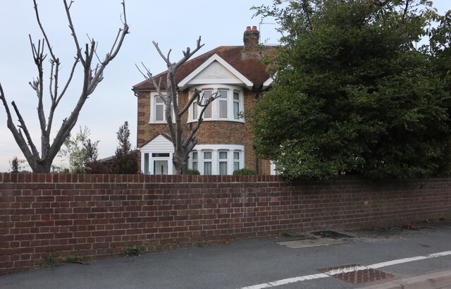
Bedfont is a small village located in the borough of Hounslow, London, England. Situated in the historic county of Middlesex, Bedfont is part of the Greater London area and is located approximately 13 miles west of central London. The village is bordered by Feltham to the north, Hatton to the west, and Stanwell to the south.

Historically, Bedfont was an agricultural community known for its fertile land, which made it an ideal location for farming. Over time, however, the village has evolved and now features a mix of residential, commercial, and industrial areas. The village center, known as Bedfont Green, offers a range of amenities including shops, restaurants, and pubs.

Bedfont's location near Heathrow Airport has also influenced its development. Many residents work in the aviation industry due to the village's proximity to the airport. Additionally, the nearby Bedfont Lakes Country Park provides a tranquil natural escape for residents and visitors alike.

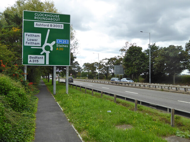
Transportation options in Bedfont are excellent, with multiple bus routes connecting the village to nearby towns and London. The village is also conveniently located near major roadways, including the M3, M4, and M25, allowing for easy access to other parts of the country.

Overall, Bedfont offers a mix of rural charm and convenient access to London and other towns. With its historical roots and modern amenities, it is a desirable place to live for those seeking a balance between urban convenience and a quieter suburban lifestyle.

If you have any feedback on the listing, please let us know in the comments section below.

Bedfont, New Images

Images are sourced within 2km of 51.458842/-0.425276 or Grid Reference TQ0974. Thanks to Geograph Open Source API. All images are credited.

Terminal 2, Heathrow Airport Viewed from a plane which had just taken off.
Terminal 2, Heathrow Airport
Viewed from a plane which had just taken off.
Hatton Cross Roundabout Primarily for servicing Heathrow Airport. It has mini-roundabouts arranged round the central core.
Hatton Cross Roundabout
Primarily for servicing Heathrow Airport. It has mini-roundabouts arranged round the central core.
Faggs Road meeting the A30 This is the junction where you must leave the A30 for Heathrow Airport. Hatton Cross Station on the Piccadilly line is the uninspiring concrete building opposite.
Faggs Road meeting the A30
This is the junction where you must leave the A30 for Heathrow Airport. Hatton Cross Station on the Piccadilly line is the uninspiring concrete building opposite.
Grazing for horses by Faggs Road The large blue building is an hotel. The other buildings behind all relate to airport activity though the horses are not under the flight path.
Grazing for horses by Faggs Road
The large blue building is an hotel. The other buildings behind all relate to airport activity though the horses are not under the flight path.
Envoy Roundabout It is on Envoy Avenue which becomes the Eastern Perimeter Road of Heathrow Airport.
Envoy Roundabout
It is on Envoy Avenue which becomes the Eastern Perimeter Road of Heathrow Airport.
Side road off Eastern Perimeter Road There is no access to the airport from this road, which has offices for airport ancillary companies, in what is called Eastern Business Park.
Side road off Eastern Perimeter Road
There is no access to the airport from this road, which has offices for airport ancillary companies, in what is called Eastern Business Park.
Enfield Road Roundabout A roundabout on Eastern Perimeter Road, but there is no public access to the airport from this roundabout.
Enfield Road Roundabout
A roundabout on Eastern Perimeter Road, but there is no public access to the airport from this roundabout.
Ancaster Nissan, Heathrow This is a wider view <a title="https://www.geograph.org.uk/photo/4220398" href="https://www.geograph.org.uk/photo/4220398">Link</a>
Ancaster Nissan, Heathrow
This is a wider view Link
House on Staines Road, Bedfont This is a wider view <a title="https://www.geograph.org.uk/photo/4220398" href="https://www.geograph.org.uk/photo/4220398">Link</a>
House on Staines Road, Bedfont
This is a wider view Link
Westbound A30 approaching Clockhouse Roundabout
Impact Proms, Manor Barn, Bedfont. 2017 The aspect from Stanwell Road. The tree has now gone, and the company is  being liquidated. The business was stated as 'Media representation services'.
Impact Proms, Manor Barn, Bedfont. 2017
The aspect from Stanwell Road. The tree has now gone, and the company is being liquidated. The business was stated as 'Media representation services'.
Impact Proms, Manor Barn, Bedfont, 2017 The aspect from Hatton Road. The tree on the left has now gone, and the company is being liquidated. The business was stated as 'Media representation services'.
Impact Proms, Manor Barn, Bedfont, 2017
The aspect from Hatton Road. The tree on the left has now gone, and the company is being liquidated. The business was stated as 'Media representation services'.
Duke of Northumberland's River An artificial cut from River Colne to River Crane, originally built in the 16th century to augment the water supply for the Duke's mills. The building of Heathrow Airport required considerable diversion, but here it remains on the original route. Looking downstream.
Duke of Northumberland's River
An artificial cut from River Colne to River Crane, originally built in the 16th century to augment the water supply for the Duke's mills. The building of Heathrow Airport required considerable diversion, but here it remains on the original route. Looking downstream.
The Beehive, East Bedfont A pub on A315 Staines Road.
The Beehive, East Bedfont
A pub on A315 Staines Road.
Duke of Northumberland's River An artificial cut from River Colne to River Crane, originally built in the 16th century to augment the water supply for the Duke's mills. The building of Heathrow Airport required considerable diversion, but here it remains on the original route. Looking downstream.
Duke of Northumberland's River
An artificial cut from River Colne to River Crane, originally built in the 16th century to augment the water supply for the Duke's mills. The building of Heathrow Airport required considerable diversion, but here it remains on the original route. Looking downstream.
Hatton Road Allotments
Foot and cycle paths from Richmond Avenue to Hatton Road School to the left, allotments to the right.
Foot and cycle paths from Richmond Avenue to Hatton Road
School to the left, allotments to the right.
Hatton Road Allotments
Show me another place!

Bedfont, New is located at Grid Ref: TQ0974 (Lat: 51.458842, Lng: -0.425276)

Unitary Authority: Hounslow

Police Authority: Metropolitan

What 3 Words

///fruit.nods.stored. Near Feltham, London

Nearby Locations

New Bedfont Bedfont, New

Related Wikis

Bedfont Sports F.C.

Bedfont Sports Football Club is a football club based in Bedfont, Greater London, England. They are currently members of the Combined Counties League Premier...

FC Deportivo Galicia

Football Club Deportivo Galicia is a football club based in London, England. They are currently members of the Combined Counties League Division One and...

Bedfont F.C.

Bedfont Football Club is a semi-professional football club in Bedfont, Greater London, England. Affiliated to the Middlesex County Football Association...

British Airways F.C.

British Airways Football Club is a football club based in Bedfont, Greater London, England. They are currently members of the Combined Counties League...

Myrtle Avenue, Hounslow

Myrtle Avenue is a street in the London Borough of Hounslow which is near the eastern end of Heathrow Airport's south runway, 27L. This makes noise when...

Rivers Academy West London

Rivers Academy West London is an 11–18 mixed secondary school and sixth form with academy status in Feltham, London, England. It specialises in business...

British Airways Flight 38

British Airways Flight 38 was a scheduled international passenger flight from Beijing Capital International Airport in Beijing, China, to London Heathrow...

Hatton Cross tube station

Hatton Cross is a combined London Underground station and bus station. It is located on the Heathrow branch of the Piccadilly line. It is in Travelcard...

Related Videos

Boarding ✈️ London Heathrow airport.#fypシ #trending #travel #youtubeshorts #uk #fyp

One of the most stunning towns in the world is Cape Town in South Africa. One of the recognised seven natural wonders of the ...

New walking destination ✈️ #travel #Heathrow #singaporeairlines

Flying to the first video filmed outside of the uk.. any guesses ? #travel #international #walking.

Nearby Amenities

Located within 500m of 51.458842,-0.425276
Post Box
Lat/Long: 51.4628107/-0.426408
Turning Circle
Lat/Long: 51.4625491/-0.4281769
Restaurant
The Duke of Wellington
Addr City: Feltham
Addr Housename: Duke Of Wellington
Addr Housenumber: 331
Addr Postcode: TW14 9QS
Addr Street: Hatton Road
Cuisine: indian
Fhrs Id: 491185
Fhrs Local Authority Id: 8779
Opening Hours: Mo-Su 12:00-23:00
Phone: +44 20 8893 1370
Website: http://www.dukeathattoncross.com/
Lat/Long: 51.4622646/-0.4275002
Traffic Calming: hump
Lat/Long: 51.4595776/-0.4304041
Noexit: yes
Lat/Long: 51.4560099/-0.4205902
Turning Circle
Lat/Long: 51.4564881/-0.4202834
Crossing
Crossing: unmarked
Lat/Long: 51.4551332/-0.4220437
Bus Stop
Cains Lane
Bus: yes
Naptan AtcoCode: 490004673N
Naptan Bearing: N
Naptan CommonName: Cains Lane
Naptan Street: HATTON ROAD
Naptan Verified: no
Public Transport: platform
Ref: 48654
Lat/Long: 51.4603303/-0.4298967
Bus Stop
Cains Lane
Bus: yes
Naptan AtcoCode: 490004673S
Naptan Bearing: N
Naptan CommonName: Cains Lane
Naptan Street: HATTON ROAD
Naptan Verified: no
Public Transport: platform
Ref: 58974
Lat/Long: 51.4598575/-0.4304381
Bus Stop
Cassiobury Avenue
Bus: yes
Departures Board: timetable
Local Ref: G
Naptan AtcoCode: 490004836E
Naptan Bearing: E
Naptan CommonName: Cassiobury Avenue
Naptan Indicator: Stop G
Naptan Street: STAINES ROAD
Naptan Verified: no
Public Transport: platform
Ref: 73709
Shelter: yes
Lat/Long: 51.454922/-0.4236032
Bus Stop
Cassiobury Avenue
Bench: yes
Bus: yes
Check Date Shelter: 2022-06-12
Local Ref: H
Naptan AtcoCode: 490004836W
Naptan Bearing: W
Naptan CommonName: Cassiobury Avenue
Naptan Indicator: Stop H
Naptan Street: STAINES ROAD
Naptan Verified: yes
Public Transport: platform
Ref: 75931
Shelter: yes
Lat/Long: 51.4551719/-0.4218626
Bus Stop
Myrtle Avenue
Bus: yes
Naptan AtcoCode: 490010142N
Naptan Bearing: N
Naptan CommonName: Myrtle Avenue
Naptan Indicator: Stop
Naptan Street: HATTON ROAD
Naptan Verified: no
Public Transport: platform
Ref: 72415
Lat/Long: 51.4629714/-0.4258993
Bus Stop
Myrtle Avenue
Bus: yes
Naptan AtcoCode: 490010142S
Naptan Bearing: S
Naptan CommonName: Myrtle Avenue
Naptan Indicator: Stop
Naptan Street: HATTON ROAD
Naptan Verified: no
Public Transport: platform
Ref: 75852
Lat/Long: 51.4624201/-0.4264692
Crossing
Crossing: unmarked
Crossing Island: yes
Kerb: lowered
Tactile Paving: yes
Lat/Long: 51.454389/-0.425629
Man Made: tower
Tower Type: communication
Lat/Long: 51.4589423/-0.4206026
Man Made: tower
Tower Type: communication
Lat/Long: 51.4594102/-0.4205154
Man Made: tower
Tower Type: communication
Lat/Long: 51.4592774/-0.420282
Barrier: bollard
Lat/Long: 51.4599286/-0.4302714
Barrier: bollard
Lat/Long: 51.4599405/-0.4302462
Crossing
Bicycle: yes
Crossing: unmarked
Kerb: lowered
Segregated: no
Tactile Paving: no
Lat/Long: 51.4546237/-0.4243698
Crossing
Crossing: unmarked
Source: local knowledge;aerial imagery;streetlevel imagery
Lat/Long: 51.4556873/-0.4222673
Crossing
Lat/Long: 51.4555194/-0.4244697
Crossing
Lat/Long: 51.4562889/-0.4246642
Barrier: bollard
Lat/Long: 51.4567372/-0.4270588
Crossing
Lat/Long: 51.4552241/-0.4271992
Crossing
Lat/Long: 51.4563526/-0.4269855
Crossing
Bicycle: yes
Crossing: unmarked
Kerb: lowered
Segregated: no
Tactile Paving: no
Lat/Long: 51.4548799/-0.4231484
Duke Of Northumberland
Board Type: history
Information: board
Tourism: information
Lat/Long: 51.4568054/-0.4271987
Crossing
Lat/Long: 51.4628085/-0.4260048
Crossing
Lat/Long: 51.4608162/-0.4289761
Crossing
Lat/Long: 51.4605339/-0.429407
Crossing
Crossing: unmarked
Crossing Island: no
Crossing Markings: no
Tactile Paving: yes
Lat/Long: 51.459653/-0.4306094
Crossing
Lat/Long: 51.459293/-0.4313005
Crossing
Crossing: unmarked
Crossing Island: no
Crossing Markings: no
Lat/Long: 51.4620105/-0.4274087
Crossing
Crossing: uncontrolled
Crossing Island: no
Crossing Markings: surface
Surface: paved
Tactile Paving: yes
Lat/Long: 51.460097/-0.4302604
Crossing
Lat/Long: 51.4586608/-0.4324596
Crossing
Lat/Long: 51.4624064/-0.4266848
Noexit: yes
Lat/Long: 51.4556843/-0.4288083
Crossing
Crossing: unmarked
Source: local knowledge;aerial imagery;streetlevel imagery
Lat/Long: 51.4555715/-0.4222142
Give Way
Direction: backward
Traffic Sign: GB:1003A
Lat/Long: 51.4551409/-0.422049
Crossing
Crossing: unmarked
Traffic Calming: table
Lat/Long: 51.4552897/-0.4220732
Direction: backward
Maxspeed: 20 mph
Traffic Sign: GB:674
Lat/Long: 51.4552626/-0.4220603
Give Way
Direction: forward
Traffic Sign: GB:1003A
Lat/Long: 51.4552516/-0.4220542
Give Way
Direction: forward
Traffic Sign: GB:1003A
Lat/Long: 51.4553635/-0.4210144
Direction: forward
Maxspeed: 20 mph
Traffic Sign: GB:674
Lat/Long: 51.4555363/-0.4208274
Crossing
Crossing: unmarked
Lat/Long: 51.4555241/-0.4208217
Crossing
Crossing: unmarked
Crossing Island: no
Lat/Long: 51.4555824/-0.4203949
Give Way
Direction: backward
Traffic Sign: GB:1003A
Lat/Long: 51.4555601/-0.4203848
Noexit: yes
Lat/Long: 51.4565068/-0.4191113
Give Way
Direction: forward
Traffic Sign: GB:1003B
Lat/Long: 51.4546299/-0.4243434
Barrier: kerb
Kerb: lowered
Lat/Long: 51.4546187/-0.4243911
Barrier: kerb
Kerb: lowered
Lat/Long: 51.4546293/-0.4243459
Level: 0
Shop: yes
Lat/Long: 51.4545739/-0.4231956
Canine Creations
Level: 0
Shop: pet_grooming
Lat/Long: 51.4546491/-0.4233605
Level: 0
Shop: convenience
Lat/Long: 51.4546725/-0.4232673
Barrier: kerb
Kerb: lowered
Lat/Long: 51.4548704/-0.4231895
Give Way
Direction: forward
Traffic Sign: GB:1003B
Lat/Long: 51.4548931/-0.4230969
Direction: forward
Maxspeed: 20 mph
Traffic Sign: GB:674
Lat/Long: 51.4548674/-0.4231416
Give Way
Direction: backward
Traffic Sign: GB:1003A
Lat/Long: 51.454911/-0.4231627
Crossing
Crossing: unmarked
Crossing Island: yes
Tactile Paving: yes
Lat/Long: 51.4549867/-0.4230139
Traffic Calming: choker
Lat/Long: 51.460698/-0.4292818
Bicycle Parking
Bicycle Parking: stands
Capacity: 4
Ref GB Tflcid: RWG233422
Lat/Long: 51.45473/-0.4232752
Crossing
Crossing: uncontrolled
Crossing Island: no
Crossing Markings: zebra;dots
Crossing Ref: zebra
Ref GB Tflcid: RWG231284
Traffic Calming: table
Lat/Long: 51.4587501/-0.4322138
Crossing
Crossing: uncontrolled
Crossing Island: no
Crossing Ref: zebra
Lat/Long: 51.4551577/-0.4222432
Crossing
Lat/Long: 51.4609379/-0.4287897
New Bedfont
Place: quarter
Lat/Long: 51.4623868/-0.426666
Give Way
Direction: backward
Lat/Long: 51.4619804/-0.4273618
Tactile Paving: yes
Lat/Long: 51.4620321/-0.4273696
Tactile Paving: yes
Lat/Long: 51.4619898/-0.4274464
Give Way
Direction: backward
Lat/Long: 51.460866/-0.4289901
Give Way
Direction: backward
Lat/Long: 51.4600863/-0.4302448
Barrier: kerb
Kerb: flush
Tactile Paving: yes
Lat/Long: 51.4601348/-0.4301942
Barrier: kerb
Kerb: flush
Tactile Paving: yes
Lat/Long: 51.460074/-0.4303007
Give Way
Direction: forward
Lat/Long: 51.4584594/-0.428953
Give Way
Direction: backward
Lat/Long: 51.4597132/-0.4306954
Tactile Paving: yes
Lat/Long: 51.4596312/-0.4306467
Tactile Paving: yes
Lat/Long: 51.4596769/-0.4305765
Tactile Paving: yes
Lat/Long: 51.4628262/-0.4260443
Give Way
Direction: backward
Lat/Long: 51.4628111/-0.4260625
Tactile Paving: yes
Lat/Long: 51.4627889/-0.4261034
Crossing
Crossing: unmarked
Crossing Island: no
Crossing Markings: no
Tactile Paving: yes
Lat/Long: 51.4628135/-0.4260668
Kerb: lowered
Tactile Paving: yes
Lat/Long: 51.4549468/-0.4229929
Kerb: lowered
Tactile Paving: yes
Lat/Long: 51.4550385/-0.4230412
Crossing
Bicycle: yes
Crossing: uncontrolled
Crossing Island: no
Crossing Ref: parallel
Lat/Long: 51.4551656/-0.4222082
Tactile Paving: yes
Lat/Long: 51.4551999/-0.422265
Tactile Paving: yes
Lat/Long: 51.4551225/-0.4222253
Give Way
Direction: backward
Lat/Long: 51.4556317/-0.4222824
Bicycle Rental
Bicycle Rental: dropoff_point
Lat/Long: 51.4552124/-0.4216757
The data included in this document is from www.openstreetmap.org. The data is made available under ODbL.

Have you been to Bedfont, New?

Leave your review of Bedfont, New below (or comments, questions and feedback).