Nantymoel

Settlement in Glamorgan

Wales

Nantymoel

Bwlch y Clawdd viewpoint – 1979 Taken during a tour of South Wales by bus enthusiasts who found time to do a bit of ordinary sightseeing here. The bus was also in need of a bit of a rest after the arduous climb up from Blaengwynfi. At this time operated by Morris Coaches of Swansea, it originated with Doncaster area independent operator Blue Ensign. It is an AEC Regent V with Roe bodywork, new in 1964, and with an interesting subsequent history. It was converted to open-top by a later operator, ending up in a transport museum in Germany.

This is one of a series of views featuring buses in the 60s, 70s, and 80s. <a title="https://www.geograph.org.uk/search.php?i=137652761" href="https://www.geograph.org.uk/search.php?i=137652761">Link</a>
Bwlch y Clawdd viewpoint – 1979 Credit: Alan Murray-Rust

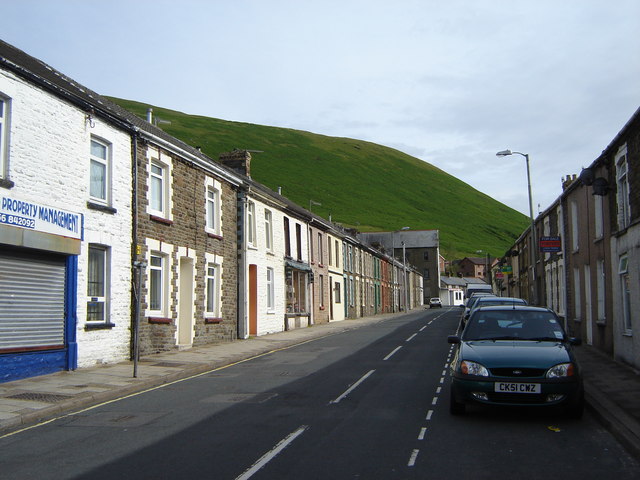
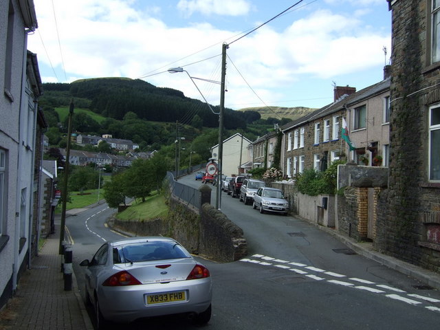
Nantymoel is a small village located in the county borough of Bridgend, Glamorgan, in Wales. Nestled in the picturesque Ogmore Valley, it is situated approximately 10 miles northwest of Bridgend town.

The village is known for its rich industrial history, primarily centered around coal mining. In the late 19th and early 20th centuries, Nantymoel flourished as a coal mining community, with several collieries operating in the vicinity. However, following the decline of the coal industry, the village underwent significant economic changes.

Today, Nantymoel is a close-knit community with a population of around 3,000 people. It offers a range of amenities to its residents, including a few local shops, a post office, and a primary school. The village is surrounded by stunning natural beauty, with the Ogmore River flowing nearby and the rolling hills of the Welsh countryside providing a scenic backdrop.

Outdoor enthusiasts are drawn to Nantymoel for its proximity to the Ogmore Valley Trail, a popular walking and cycling route that stretches for 16 miles along the former Ogmore Valley Railway. The trail offers breathtaking views and a chance to explore the area's industrial heritage.

Overall, Nantymoel is a small but vibrant village that combines its industrial past with its natural beauty. It provides a peaceful and picturesque setting for residents and visitors alike, showcasing the charm and character of rural Wales.

If you have any feedback on the listing, please let us know in the comments section below.

Nantymoel Images

Images are sourced within 2km of 51.623958/-3.546421 or Grid Reference SS9392. Thanks to Geograph Open Source API. All images are credited.

Bwlch y Clawdd viewpoint – 1979 Taken during a tour of South Wales by bus enthusiasts who found time to do a bit of ordinary sightseeing here. The bus was also in need of a bit of a rest after the arduous climb up from Blaengwynfi. At this time operated by Morris Coaches of Swansea, it originated with Doncaster area independent operator Blue Ensign. It is an AEC Regent V with Roe bodywork, new in 1964, and with an interesting subsequent history. It was converted to open-top by a later operator, ending up in a transport museum in Germany.

This is one of a series of views featuring buses in the 60s, 70s, and 80s. <a title="https://www.geograph.org.uk/search.php?i=137652761" href="https://www.geograph.org.uk/search.php?i=137652761">Link</a>
Bwlch y Clawdd viewpoint – 1979
Taken during a tour of South Wales by bus enthusiasts who found time to do a bit of ordinary sightseeing here. The bus was also in need of a bit of a rest after the arduous climb up from Blaengwynfi. At this time operated by Morris Coaches of Swansea, it originated with Doncaster area independent operator Blue Ensign. It is an AEC Regent V with Roe bodywork, new in 1964, and with an interesting subsequent history. It was converted to open-top by a later operator, ending up in a transport museum in Germany. This is one of a series of views featuring buses in the 60s, 70s, and 80s. Link
Ordnance Survey Pivot This OS pivot can be found on a stone west edge of the path. It marks a point 1680.38ft above mean sea level.
Ordnance Survey Pivot
This OS pivot can be found on a stone west edge of the path. It marks a point 1680.38ft above mean sea level.
Carn-yr-hyrddod
Carn-yr-hyrddod
Japanese knotweed and Himalayan balsam Invasive species taking over the banks of the Ogmore River.
Japanese knotweed and Himalayan balsam
Invasive species taking over the banks of the Ogmore River.
Oxford Court Blocks of flats built in the 1960s, now awaiting demolition.
Oxford Court
Blocks of flats built in the 1960s, now awaiting demolition.
Rugby in the Welsh valleys Rugby pitch between Ogmore Vale and Nantymoel.
Rugby in the Welsh valleys
Rugby pitch between Ogmore Vale and Nantymoel.
Bethel Chapel, Nantymoel Another sign of the depressed condition of the Welsh valleys. The chapel, built in 1877, is steadily deteriorating despite plans 15 years ago to turn it into a residential care home.
Bethel Chapel, Nantymoel
Another sign of the depressed condition of the Welsh valleys. The chapel, built in 1877, is steadily deteriorating despite plans 15 years ago to turn it into a residential care home.
Formerly the Nantymoel Hotel In its heyday a convenient hotel close to the railway station. Now, yet another sign of a run-down valleys community.  A close look at the pub sign reveals the remaining letters of Welsh Brewers (above) and Nantymoel (below).
Formerly the Nantymoel Hotel
In its heyday a convenient hotel close to the railway station. Now, yet another sign of a run-down valleys community. A close look at the pub sign reveals the remaining letters of Welsh Brewers (above) and Nantymoel (below).
Walking along the old railway line Approaching Nantymoel. In the distance is Craig Ogwr at the head of the Ogwr Fawr. The river enters the Bristol Channel 12 miles away at Ogmore by Sea.
Walking along the old railway line
Approaching Nantymoel. In the distance is Craig Ogwr at the head of the Ogwr Fawr. The river enters the Bristol Channel 12 miles away at Ogmore by Sea.
Amiable Sheep When I arrived at this location I was intrigued by how docile the local sheep were - they ran to the car as I arrived and were almost jumping over themselves when I pulled the camera out of its bag.  The reason became apparent almost immediately.  I was only there for a couple of minutes but three separate individuals turned up with scraps to feed them.  It seems that this is a spot where locals come to feed the sheep...
Amiable Sheep
When I arrived at this location I was intrigued by how docile the local sheep were - they ran to the car as I arrived and were almost jumping over themselves when I pulled the camera out of its bag. The reason became apparent almost immediately. I was only there for a couple of minutes but three separate individuals turned up with scraps to feed them. It seems that this is a spot where locals come to feed the sheep...
View towards Treorchy A view towards Treorchy from the nearby viewpoint.
View towards Treorchy
A view towards Treorchy from the nearby viewpoint.
Cascade at hairpin bend above Nant-y-Moel On the hill pass from Treorci (Treorchy) to Nant-y-Moel is this impressive waterfall under Tarren Rhiw Maen.
Cascade at hairpin bend above Nant-y-Moel
On the hill pass from Treorci (Treorchy) to Nant-y-Moel is this impressive waterfall under Tarren Rhiw Maen.
Terraced housing on the A4061, Price Town
Nant-y-moel Post Office, Price Town
A4061 just before, and just after, a big hairpin bend. The road climbs towards me, loops around the hairpin bend (off shot,left), and continues its ascending route along the middle of the photo, with the magnificent Craig Ogwr above it.
A4061 just before, and just after, a big hairpin bend.
The road climbs towards me, loops around the hairpin bend (off shot,left), and continues its ascending route along the middle of the photo, with the magnificent Craig Ogwr above it.
Dramatic portal into the A4107
The ice cream van attracts all sorts...
Wyndham From Cwm Ogwr Fawr Chapel visible centre left of photo
Wyndham From Cwm Ogwr Fawr
Chapel visible centre left of photo
Show me another place!

Nantymoel is located at Grid Ref: SS9392 (Lat: 51.623958, Lng: -3.546421)

Unitary Authority: Bridgend

Police Authority: South Wales

Also known as: Nant-y-moel

What 3 Words

///irritate.shook.exacted. Near Price Town, Bridgend

Related Wikis

Nantymoel railway station

Nantymoel railway station served the village of Nant-y-moel, in the historical county of Glamorgan, Wales, from 1873 to 1958 on the Ogmore Valley Railway...

Nant-y-moel

Nant-y-moel or Nantymoel [nant ə mɔi̯l] (meaning "stream from the bare mountain") is a village and includes the formerly separate village of Pricetown...

A4061 road

The A4061 is the main road linking Bridgend with Hirwaun via the Ogmore and Rhondda Valleys in South Wales. It is a mix of streets connecting former mining...

Price Town

Price Town is situated 9 miles north of the County Town of Bridgend on the A4061 road in the upper reaches of the Cwm Ogwr Fawr (the Greater Ogmore Valley...

Nearby Amenities

Located within 500m of 51.623958,-3.546421
Nant-y-moel
Place: village
Wikidata: Q6964400
Lat/Long: 51.6259632/-3.5415682
Turning Circle
Lat/Long: 51.6261991/-3.54671
Turning Circle
Lat/Long: 51.625024/-3.5450077
Post Box
Collection Times: Mo-Fr 09:00; Sa 07:00
Operator: Royal Mail
Post Box Mounting: pier
Post Box Type: lamp
Ref: CF32 94D
Royal Cypher: EIIR
Royal Cypher Wikidata: Q33102113
Lat/Long: 51.6245548/-3.5402993
Give Way
Direction: forward
Lat/Long: 51.6243691/-3.5399774
Post Box
Collection Times: Mo-Fr 09:00; Sa 07:00
Operator: Royal Mail
Post Box Mounting: pier
Post Box Type: lamp
Ref: CF32 38D
Royal Cypher: EIIR
Royal Cypher Wikidata: Q33102113
Lat/Long: 51.627266/-3.5423713
Nantymoel
Historic Railway: station
Railway: site
Wikidata: Q106616281
Wikipedia: en:Nantymoel railway station
Lat/Long: 51.6262972/-3.5423467
The data included in this document is from www.openstreetmap.org. The data is made available under ODbL.

Have you been to Nantymoel?

Leave your review of Nantymoel below (or comments, questions and feedback).