Muness

Settlement in Shetland

Scotland

Muness

Ruined crofthouse on the Ness of Ramnageo
Ruined crofthouse on the Ness of Ramnageo Credit: Mike Pennington

Muness is a small community located in the Shetland Islands, an archipelago in the northernmost part of Scotland. Situated on the island of Unst, Muness is known for its picturesque beauty and rich history. It is the most northerly inhabited place in the United Kingdom.

One of the main attractions in Muness is Muness Castle, a magnificent 16th-century fortress. Built by Laurence Bruce, it is the most northerly castle in the British Isles. Despite being partially ruined, the castle's imposing structure still stands tall and offers visitors a glimpse into its past grandeur.

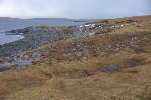
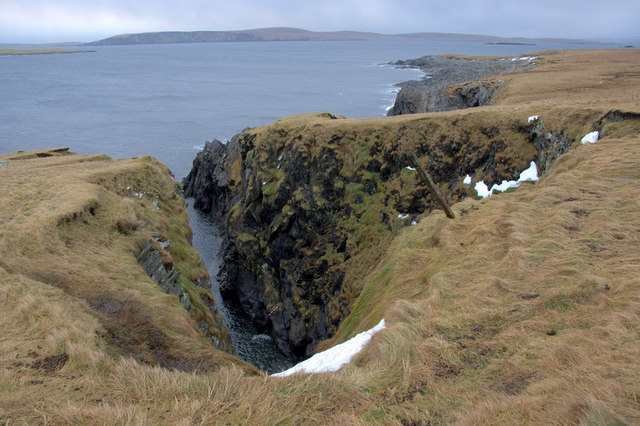
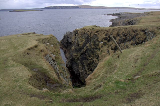
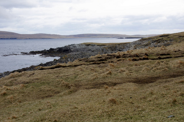
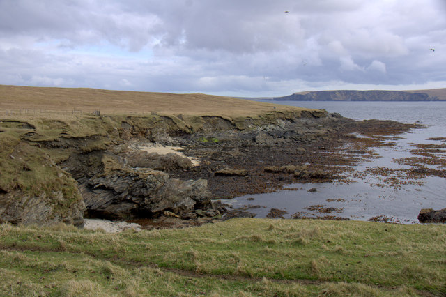
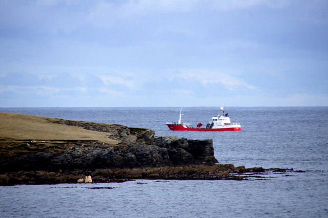
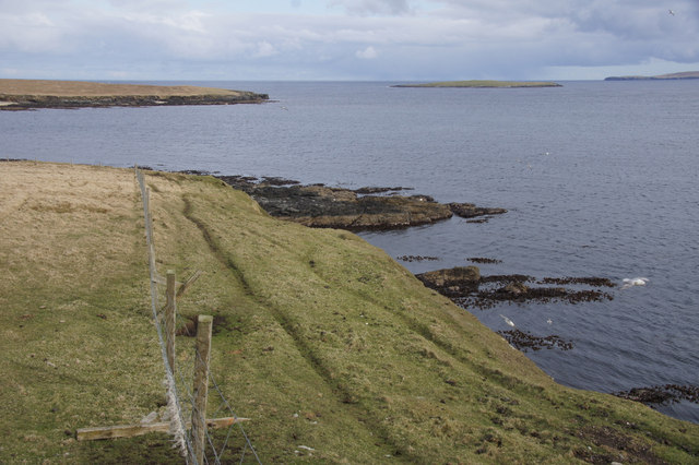
Muness is also renowned for its stunning natural landscapes. The area is characterized by rolling hills, pristine beaches, and dramatic cliffs, providing ample opportunities for outdoor enthusiasts to explore and appreciate the island's breathtaking beauty. The coastline is a haven for birdwatchers, as it is home to a variety of seabirds, including puffins, guillemots, and razorbills.

The local community in Muness is small but welcoming, with a strong sense of community spirit. Traditional Shetland culture and heritage are celebrated through various events and festivals throughout the year, including music and dance performances, crafts exhibitions, and agricultural shows.

Although Muness may be remote, it is well-connected to the rest of the Shetland Islands by ferry services and an airport. This allows visitors and residents to easily access amenities and explore the wider region, which offers further natural wonders, historical sites, and charming villages.

If you have any feedback on the listing, please let us know in the comments section below.

Muness Images

Images are sourced within 2km of 60.686973/-0.846447 or Grid Reference HP6300. Thanks to Geograph Open Source API. All images are credited.

Ruined crofthouse on the Ness of Ramnageo
Ness of Ramnageo A ruined planticrub (shelter for growing crops) on the Ness; Fetlar is in the distance.
Ness of Ramnageo
A ruined planticrub (shelter for growing crops) on the Ness; Fetlar is in the distance.
Beaches on the west of the Ness of Ramnageo The ruined croft at Littlegarth can just be seen in the distance.
Beaches on the west of the Ness of Ramnageo
The ruined croft at Littlegarth can just be seen in the distance.
Coastline below Littlegarth Uyea isle is in the distance.
Coastline below Littlegarth
Uyea isle is in the distance.
Cliffs at Littlegarth Fulmars are beginning to return to ledges left empty for most of the winter.
Cliffs at Littlegarth
Fulmars are beginning to return to ledges left empty for most of the winter.
Wick of Fauld Looking across the wick from Littlegarth towards Ramnageo.
Wick of Fauld
Looking across the wick from Littlegarth towards Ramnageo.
Beach on Ness of Ramnageo Looking towards Fetlar.
Beach on Ness of Ramnageo
Looking towards Fetlar.
Wick of Fauld from Ramnageo Looking towards Littlegarth.
Wick of Fauld from Ramnageo
Looking towards Littlegarth.
Ness of Ramnageo Looking out towards Wedder Holm, with Fetlar in the distance.
Ness of Ramnageo
Looking out towards Wedder Holm, with Fetlar in the distance.
Scranklings, Ness of Ramnageo This unusual piece of coastline along the east side of the Ness of Ramnageo has the strangely appropriate-sounding name of Scranklings, according to the 1:10,000 map.
Scranklings, Ness of Ramnageo
This unusual piece of coastline along the east side of the Ness of Ramnageo has the strangely appropriate-sounding name of Scranklings, according to the 1:10,000 map.
Stubbi Geos, Ramnageo I had always assumed that at least one of these geos was the eponymous Ramnageo ('Raven's geo') but according to the map they are named Stubbi Geos.
Stubbi Geos, Ramnageo
I had always assumed that at least one of these geos was the eponymous Ramnageo ('Raven's geo') but according to the map they are named Stubbi Geos.
Wester Stubbi Geo, Ness of Ramnageo Looking south towards Fetlar, with Haaf Gruney on the left and Wedder Hom on the right.
Wester Stubbi Geo, Ness of Ramnageo
Looking south towards Fetlar, with Haaf Gruney on the left and Wedder Hom on the right.
Easter Stubbi Geo, Ness of Ramnageo The top of the cliff is in one gridsquare, but the bottom of the cliff is in the next.
Easter Stubbi Geo, Ness of Ramnageo
The top of the cliff is in one gridsquare, but the bottom of the cliff is in the next.
Stubbi Geos, Ramnageo, Muness
Scranklings, Ness of Ramnageo, Muness
Gorse Geos, Ness of Ramnageo, Muness
MV Gripfisk passing Ness of Ramnageo, Muness The Gripfisk is a Norwegian-registered vessel, presumably a fish carrier. It is the only vessel I've seen pass through the sound between Haaf Gruney and Ness and Ramnageo.
MV Gripfisk passing Ness of Ramnageo, Muness
The Gripfisk is a Norwegian-registered vessel, presumably a fish carrier. It is the only vessel I've seen pass through the sound between Haaf Gruney and Ness and Ramnageo.
The Raabs, Ness of Littlegarth, Muness
Show me another place!

Muness is located at Grid Ref: HP6300 (Lat: 60.686973, Lng: -0.846447)

Unitary Authority: Shetland Islands

Police Authority: Highlands and Islands

What 3 Words

///cleanser.owns.unrated. Near Uyeasound, Shetland Islands

Related Wikis

Muness Castle

Muness Castle is located on Unst, which is one of the Shetland Islands of Scotland. The castle is 3 kilometres (1.9 mi) east of the village of Uyeasound...

Haaf Gruney

Haaf Gruney is a small island in the north east of the Shetland Islands. == Geography and geology == The island is between Unst and Fetlar which are to...

Mailand, Shetland

Mailand is a hamlet in the Shetland Islands. It is on the island of Unst, the northernmost of the inhabited British Isles, near its southern coast. �...

Clivocast

Clivocast is a settlement on the island of Unst in the Shetland Islands, Scotland at 60.67°N 00.90°W / 60.67; -00.90 or grid reference HP6000 and is situated...

Nearby Amenities

Located within 500m of 60.686973,-0.846447
Barrier: cattle_grid
Lat/Long: 60.6866055/-0.8465107
Muness
Place: hamlet
Lat/Long: 60.6894284/-0.8494232
Passing Place
Lat/Long: 60.6891088/-0.8498616
Barrier: cattle_grid
Lat/Long: 60.6877337/-0.8465303
Barrier: cattle_grid
Lat/Long: 60.6899189/-0.8511387
Passing Place
Lat/Long: 60.6844676/-0.8497426
Power: pole
Lat/Long: 60.6878436/-0.8463682
Power: pole
Lat/Long: 60.6864983/-0.8555467
Power: pole
Lat/Long: 60.6866362/-0.854337
Power: pole
Lat/Long: 60.686845/-0.8526714
Power: pole
Lat/Long: 60.6870236/-0.8511107
Power: pole
Lat/Long: 60.6871903/-0.8496217
Power: pole
Lat/Long: 60.6873237/-0.8484323
Power: pole
Lat/Long: 60.6874713/-0.847197
Power: pole
Lat/Long: 60.6853841/-0.8475362
Power: pole
Lat/Long: 60.6859954/-0.8482238
Power: pole
Lat/Long: 60.6865934/-0.8489139
Power: pole
Lat/Long: 60.6877345/-0.8497554
Power: pole
Lat/Long: 60.6884077/-0.8499316
Power: pole
Lat/Long: 60.6889254/-0.8500731
Power: pole
Lat/Long: 60.6892754/-0.8501724
Power: pole
Lat/Long: 60.6896387/-0.8501377
Power: pole
Lat/Long: 60.6899583/-0.8501029
Power: pole
Lat/Long: 60.6897092/-0.8493533
Power: pole
Lat/Long: 60.6847503/-0.8491857
Power: pole
Lat/Long: 60.6849107/-0.8487774
Power: pole
Lat/Long: 60.685107/-0.8482759
Power: pole
Lat/Long: 60.6855761/-0.8470298
Power: pole
Lat/Long: 60.685835/-0.8463919
The data included in this document is from www.openstreetmap.org. The data is made available under ODbL.

Have you been to Muness?

Leave your review of Muness below (or comments, questions and feedback).