Moulton

Settlement in Lincolnshire South Holland

England

Moulton

Spalding Gate
Spalding Gate Credit: Alex McGregor

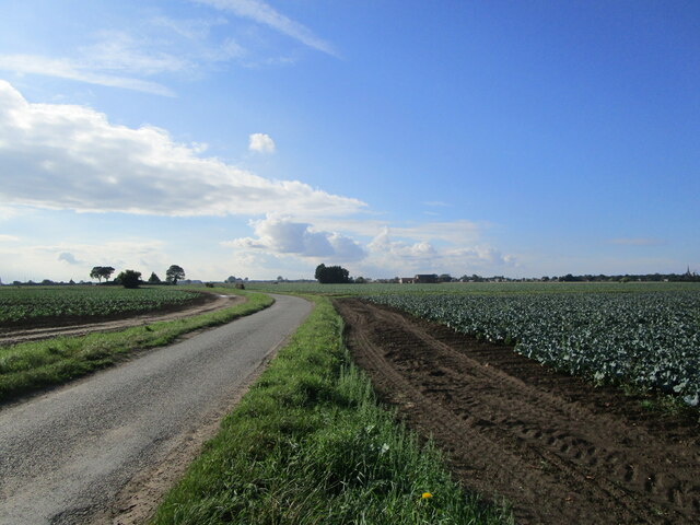
Moulton is a picturesque village located in Lincolnshire, England. Situated approximately 5 miles north of the vibrant city of Spalding, it lies in the South Holland district and has a population of around 3,500 residents. Moulton is surrounded by beautiful countryside, offering a tranquil and idyllic setting.

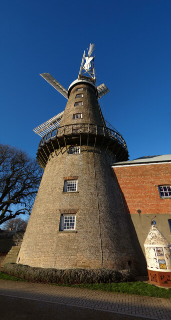
One of the key attractions in Moulton is the historic Moulton Mill, a Grade I listed windmill dating back to the early 19th century. This well-preserved mill stands as a testament to the village's rich agricultural heritage. Additionally, Moulton boasts several other notable landmarks, including the charming All Saints' Church, which features an impressive 15th-century tower.

The village is home to a vibrant community, with various amenities and services available to residents and visitors. These include a primary school, a post office, a village hall, and a range of local shops, pubs, and restaurants. Moulton also has a strong sense of community spirit, with regular events and activities organized throughout the year, such as the Moulton Feast, a traditional summer fair that has been celebrated for centuries.

The surrounding area offers plenty of opportunities for outdoor activities, with numerous walking and cycling routes, as well as beautiful parks and nature reserves nearby. Additionally, Moulton is well-connected to the wider region, with good transport links, including bus services and easy access to major roads such as the A151 and A16.

Overall, Moulton is a charming and welcoming village, blending history, natural beauty, and a strong sense of community, making it an appealing place to live or visit in Lincolnshire.

If you have any feedback on the listing, please let us know in the comments section below.

Moulton Images

Images are sourced within 2km of 52.798831/-0.063289722 or Grid Reference TF3024. Thanks to Geograph Open Source API. All images are credited.

Spalding Gate
Spalding Gate
Spalding Gate
Spalding Gate
Field off Spalding Gate
Whaplode Village Hall
The churchyard, Whaplode Most of the churchyard has been cleared of gravestones though some remain in this south-east corner.
The churchyard, Whaplode
Most of the churchyard has been cleared of gravestones though some remain in this south-east corner.
Little Lane and fields of brassicas
Stubble field alongside Hog's Lane The white house is the former level crossing gatekeeper's house on the Midland and Great Northern Joint Railway line.
Stubble field alongside Hog's Lane
The white house is the former level crossing gatekeeper's house on the Midland and Great Northern Joint Railway line.
Stubble field near Moulton The windmill and parish church prominent in the distance.
Stubble field near Moulton
The windmill and parish church prominent in the distance.
Harrox House, Moulton Dates from the late eighteenth century <span class="nowrap"><a title="https://historicengland.org.uk/listing/the-list/list-entry/1064506" rel="nofollow ugc noopener" href="https://historicengland.org.uk/listing/the-list/list-entry/1064506">Link</a><img style="margin-left:2px;" alt="External link" title="External link - shift click to open in new window" src="https://s1.geograph.org.uk/img/external.png" width="10" height="10"/></span>
Harrox House, Moulton
Dates from the late eighteenth century LinkExternal link
Now that's one tall windmill! Three images stitched together in order to take in the whole of Britain's tallest mill, Moulton Windmill.  I now have a stiff neck!
Now that's one tall windmill!
Three images stitched together in order to take in the whole of Britain's tallest mill, Moulton Windmill. I now have a stiff neck!
Moulton Fish & Chips What a pity it was closed. I could have done with a nice hot lunch.  
It might have been sunny, but the NW wind was cold and quite strong.
Moulton Fish & Chips
What a pity it was closed. I could have done with a nice hot lunch. It might have been sunny, but the NW wind was cold and quite strong.
Snowdrops at St Mary's Church
All Saint's Church, Moulton, Lincolnshire “The Queen of the Fens” dates back to about 1180, the spire is about 158 feet high.
All Saint's Church, Moulton, Lincolnshire
“The Queen of the Fens” dates back to about 1180, the spire is about 158 feet high.
Junction West Cob Gate and Station Road, Moulton
Moulton Windmill The tallest tower mill in the United Kingdom.

Dating back to 1822 it is Grade I listed and 9 stories high. For more details see; <span class="nowrap"><a title="https://en.wikipedia.org/wiki/Moulton_Windmill" rel="nofollow ugc noopener" href="https://en.wikipedia.org/wiki/Moulton_Windmill">Link</a><img style="margin-left:2px;" alt="External link" title="External link - shift click to open in new window" src="https://s1.geograph.org.uk/img/external.png" width="10" height="10"/></span>
Moulton Windmill
The tallest tower mill in the United Kingdom. Dating back to 1822 it is Grade I listed and 9 stories high. For more details see; LinkExternal link
Moulton Windmill The tallest tower mill in the United Kingdom.

Dating back to 1822 it is Grade I listed and 9 stories high.
Moulton Windmill
The tallest tower mill in the United Kingdom. Dating back to 1822 it is Grade I listed and 9 stories high.
Moulton Church and Windmill: aerial 2023 (1) Windmill is the tallest tower mill in the United Kingdom.

Dated 1822 it is Grade I listed and 9 stories high. 

New sails were fitted on 21 November 2011 to complete the restoration of the mill. The community restoration took 14 years to complete at a cost of nearly £2m.

See: <span class="nowrap"><a title="https://en.wikipedia.org/wiki/Moulton_Windmill" rel="nofollow ugc noopener" href="https://en.wikipedia.org/wiki/Moulton_Windmill">Link</a><img style="margin-left:2px;" alt="External link" title="External link - shift click to open in new window" src="https://s1.geograph.org.uk/img/external.png" width="10" height="10"/></span>
Moulton Church and Windmill: aerial 2023 (1)
Windmill is the tallest tower mill in the United Kingdom. Dated 1822 it is Grade I listed and 9 stories high. New sails were fitted on 21 November 2011 to complete the restoration of the mill. The community restoration took 14 years to complete at a cost of nearly £2m. See: LinkExternal link
Show me another place!

Moulton is located at Grid Ref: TF3024 (Lat: 52.798831, Lng: -0.063289722)

Division: Parts of Holland

Administrative County: Lincolnshire

District: South Holland

Police Authority: Lincolnshire

What 3 Words

///disco.materials.accusing. Near Whaplode, Lincolnshire

Nearby Locations

Moulton

Related Wikis

Moulton Windmill

Moulton Windmill in the Lincolnshire village of Moulton, between Spalding and Holbeach is a restored windmill claimed to be the tallest tower mill in the...

Moulton, Lincolnshire

Moulton is a village in the civil parish of The Moultons, in the South Holland district of Lincolnshire, England. It is situated on the A151 and B1537...

Moulton railway station (Lincolnshire)

Moulton (Lincolnshire) railway station was a station in Moulton, Lincolnshire. Built by the Norwich and Spalding Railway, (later Midland and Great Northern...

Whaplode railway station

Whaplode railway station was a station in Whaplode, Lincolnshire. Built by the Norwich and Spalding Railway, (later Midland and Great Northern Joint Railway...

Nearby Amenities

Located within 500m of 52.798831,-0.063289722
Moulton
Is In: Lincolnshire, England, UK
Place: village
Wikidata: Q6919037
Lat/Long: 52.7976255/-0.0633179
Bus Stop
Hatt Close
Bench: no
Bin: yes
Bus: yes
Departures Board: timetable
Lit: no
Naptan AtcoCode: 270000009465
Naptan Bearing: N
Naptan CommonName: Hatt Close
Naptan Indicator: adj
Naptan Landmark: Hatt Close
Naptan NaptanCode: linjawtj
Naptan Street: Bell Lane
Naptan Verified: no
Operator: Stagecoach
Shelter: no
Source: naptan_import
Tactile Paving: no
Wheelchair: yes
Lat/Long: 52.8029572/-0.0633702
Bus Stop
Hatt Close
Naptan AtcoCode: 270000009466
Naptan Bearing: S
Naptan CommonName: Hatt Close
Naptan Indicator: opp
Naptan Landmark: Hatt Close
Naptan NaptanCode: linjawtm
Naptan Street: Bell Lane
Naptan Verified: no
Source: naptan_import
Lat/Long: 52.8028599/-0.0632427
Bus Stop
Medical Centre
Naptan AtcoCode: 270000010594
Naptan Bearing: E
Naptan CommonName: Medical Centre
Naptan Landmark: Medical Centre
Naptan NaptanCode: linjpagp
Naptan Street: West Cob Gate
Naptan Verified: no
Source: naptan_import
Lat/Long: 52.7960327/-0.0630316
Bus Stop
West Cob Gate
Naptan AtcoCode: 270000010595
Naptan Bearing: NE
Naptan CommonName: West Cob Gate
Naptan Landmark: Moons Green
Naptan NaptanCode: linjpagt
Naptan Street: West Cob Gate
Naptan Verified: no
Source: naptan_import
Lat/Long: 52.7956286/-0.0652363
Bus Stop
Harrox Square
Naptan AtcoCode: 270000010596
Naptan Bearing: NW
Naptan CommonName: Harrox Square
Naptan Indicator: adj
Naptan Landmark: Harrox Square
Naptan NaptanCode: linjpagw
Naptan Street: Moons Green
Naptan Verified: no
Source: naptan_import
Lat/Long: 52.7944272/-0.0634876
Bus Stop
Reynolds Gardens
Naptan AtcoCode: 270002701095
Naptan Bearing: S
Naptan CommonName: Reynolds Gardens
Naptan Indicator: opp
Naptan Landmark: Reynolds Gardens
Naptan Street: Bell Lane
Naptan Verified: no
Source: naptan_import
Lat/Long: 52.8013993/-0.0630706
Bus Stop
Reynolds Gardens
Naptan AtcoCode: 270002701096
Naptan Bearing: N
Naptan CommonName: Reynolds Gardens
Naptan Indicator: adj
Naptan Landmark: Reynolds Gardens
Naptan Street: Bell Lane
Naptan Verified: no
Source: naptan_import
Lat/Long: 52.8008446/-0.0630081
Bus Stop
Medical Centre
Naptan AtcoCode: 2700LM000128
Naptan Bearing: S
Naptan CommonName: Medical Centre
Naptan Indicator: adj
Naptan Landmark: Medical Centre
Naptan NaptanCode: linadgam
Naptan Street: High Street
Naptan Verified: no
Source: naptan_import
Lat/Long: 52.7962345/-0.0626606
Bus Stop
All Saint's Church
Naptan AtcoCode: 2700LMC01144
Naptan Bearing: S
Naptan CommonName: All Saint's Church
Naptan Indicator: adj
Naptan Landmark: All Saint's Church
Naptan NaptanCode: linajdjp
Naptan Street: High Street
Naptan Verified: no
Source: naptan_import
Lat/Long: 52.7985071/-0.0631329
Post Box
Collection Times: Mo-Fr 16:45; Sa 11:00
Description: In wall of Moulton Post Office.
Operator: Royal Mail
Post Box Type: wall
Ref: PE12 114
Royal Cypher: GR
Royal Cypher Wikidata: Q33102273
Lat/Long: 52.7983825/-0.0630315
Post Office
Moulton Post Office
Addr City: Spalding
Addr Country: GB
Addr Postcode: PE12 6QB
Addr Suburb: Moulton
Brand: Post Office
Brand Wikidata: Q1783168
Contact Website: https://www.postoffice.co.uk/branch-finder/2522306/moulton
Ref Pol Id: 9936
Lat/Long: 52.7984578/-0.0629327
Moulton Butchers
Addr City: Spalding
Addr Country: GB
Addr Housenumber: 18
Addr Postcode: PE12 6QB
Addr Street: High Street
Addr Suburb: Moulton
Fhrs Authority: South Holland
Fhrs Id: 243325
Fhrs Local Authority Id: 26957
Shop: butcher
Lat/Long: 52.7982264/-0.0629034
Fast Food
Fish and Chips
Addr City: Spalding
Addr Country: GB
Addr Housenumber: 15
Addr Postcode: PE12 6QB
Addr Street: High Street
Addr Suburb: Moulton
Cuisine: fish_and_chips
Fhrs Authority: South Holland
Fhrs Id: 243219
Fhrs Local Authority Id: 5473
Takeaway: yes
Lat/Long: 52.7977963/-0.0630119
Addr Housenumber: 25
Addr Street: Reynolds Gardens
Lat/Long: 52.8010989/-0.0638711
Addr Housenumber: 23
Addr Street: Reynolds Gardens
Lat/Long: 52.8010643/-0.0640976
Addr Housenumber: 21
Addr Street: Reynolds Gardens
Lat/Long: 52.8010643/-0.0643241
Addr Housenumber: 19
Addr Street: Reynolds Gardens
Lat/Long: 52.8011335/-0.0645424
Addr Housenumber: 17
Addr Street: Reynolds Gardens
Lat/Long: 52.8011151/-0.0647946
Addr Housenumber: 15
Addr Street: Reynolds Gardens
Lat/Long: 52.8009747/-0.064902
The Little Village Salon
Shop: beauty
Lat/Long: 52.7983465/-0.0635348
Moulton Harrox Sports and Social Society
Addr City: Spalding
Addr Country: GB
Addr Postcode: PE12 6PN
Addr Street: Broad Lane
Addr Suburb: Moulton
Fhrs Authority: South Holland
Fhrs Id: 242992
Fhrs Local Authority Id: 1995
Leisure: sports_centre
Lat/Long: 52.7981065/-0.0645219
Defibrillator
Defibrillator Location: outside Moulton Community Centre - to left of entrance
Emergency: defibrillator
Indoor: no
Lat/Long: 52.797938/-0.0646316
Generator Method: photovoltaic
Generator Output Electricity: yes
Generator Source: solar
Generator Type: solar_photovoltaic_panel
Location: roof
Power: generator
Lat/Long: 52.8021016/-0.0597985
Generator Method: photovoltaic
Generator Output Electricity: yes
Generator Source: solar
Generator Type: solar_photovoltaic_panel
Location: roof
Power: generator
Lat/Long: 52.8014076/-0.0592996
Generator Method: photovoltaic
Generator Output Electricity: yes
Generator Source: solar
Generator Type: solar_photovoltaic_panel
Location: roof
Power: generator
Lat/Long: 52.7995849/-0.0636796
Generator Method: photovoltaic
Generator Output Electricity: yes
Generator Source: solar
Generator Type: solar_photovoltaic_panel
Location: roof
Power: generator
Lat/Long: 52.7972496/-0.0642536
Generator Method: photovoltaic
Generator Output Electricity: yes
Generator Source: solar
Generator Type: solar_photovoltaic_panel
Location: roof
Power: generator
Lat/Long: 52.7945136/-0.0645755
Generator Method: photovoltaic
Generator Output Electricity: yes
Generator Source: solar
Generator Type: solar_photovoltaic_panel
Location: roof
Power: generator
Lat/Long: 52.7945566/-0.064664
Generator Method: photovoltaic
Generator Output Electricity: yes
Generator Source: solar
Generator Type: solar_photovoltaic_panel
Location: roof
Power: generator
Lat/Long: 52.7975858/-0.0687356
Generator Method: photovoltaic
Generator Output Electricity: yes
Generator Source: solar
Generator Type: solar_photovoltaic_panel
Location: roof
Power: generator
Lat/Long: 52.8010092/-0.0654231
Generator Method: photovoltaic
Generator Output Electricity: yes
Generator Source: solar
Generator Type: solar_photovoltaic_panel
Location: roof
Power: generator
Lat/Long: 52.8026324/-0.0648571
Historic: water_well
Lat/Long: 52.7988271/-0.0635225
Public Bookcase
Moulton Book Exchange
Booth: K6
Disused Amenity: telephone
Listed Status: Grade II
Man Made: telephone_box
Old Phone: +44 1406 370245
Public Bookcase Type: phone_box
Lat/Long: 52.7983884/-0.0635708
Entrance: yes
Lat/Long: 52.7979556/-0.0646328
The data included in this document is from www.openstreetmap.org. The data is made available under ODbL.

Have you been to Moulton?

Leave your review of Moulton below (or comments, questions and feedback).