Mostyn

Settlement in Flintshire

Wales

Mostyn

Drybridge Lodge, Rhewl Mostyn The carriage drive for Mostyn Hall has the public road dive under in the tunnel
Drybridge Lodge, Rhewl Mostyn Credit: Kevin Waterhouse

Mostyn is a village located in the county of Flintshire, in northeast Wales. Situated on the coast of the Dee Estuary, it lies approximately 11 miles to the east of the town of Holywell and 6 miles to the west of the city of Chester, across the border in England. The village is part of the community of Mostyn and is home to around 1,200 residents.

Historically, Mostyn was an important industrial center during the 19th and early 20th centuries, primarily due to its proximity to the coal and chemical industries. The village was dominated by the Mostyn Colliery, which employed a large number of local workers. Today, the colliery is closed, but remnants of its industrial past can still be seen in the form of old mine buildings and railway tracks.

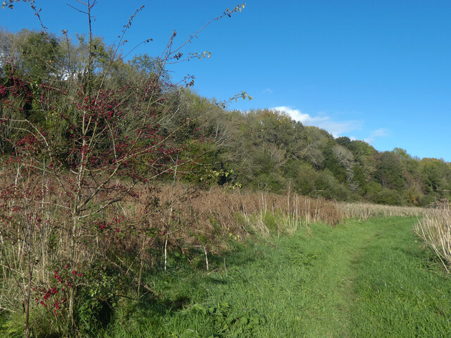
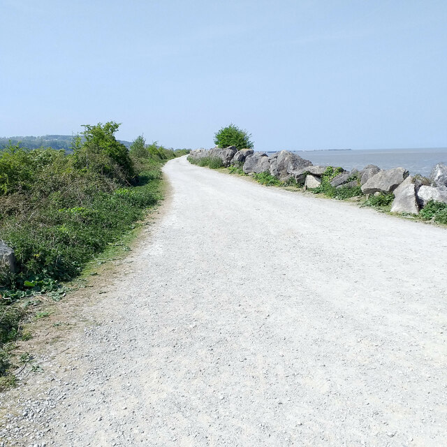
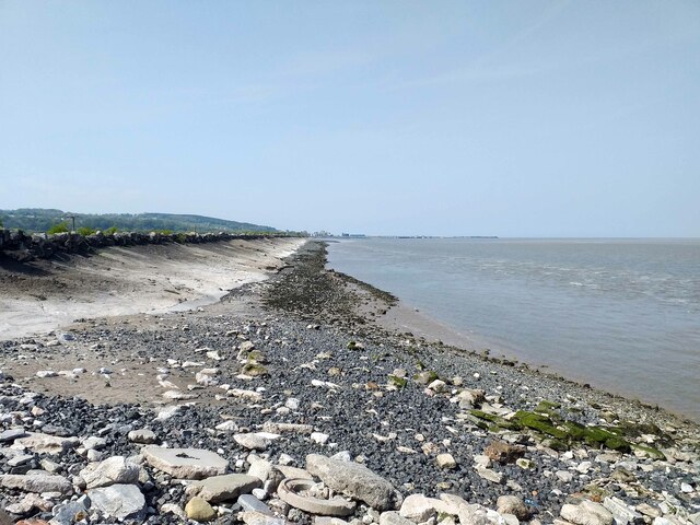
Mostyn is also known for its picturesque coastal location, with stunning views across the Dee Estuary towards the Wirral Peninsula. The village is a popular spot for birdwatchers, as it lies within the Dee Estuary Special Protection Area, attracting a wide variety of bird species throughout the year.

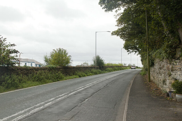
In terms of amenities, Mostyn offers a range of services for its residents and visitors. These include a primary school, a community center, a post office, and a few local shops. The village is also easily accessible, with good transport links to nearby towns and cities via the A548 road.

Overall, Mostyn is a small but historically significant village with a beautiful coastal setting, providing a peaceful and scenic environment for its inhabitants.

If you have any feedback on the listing, please let us know in the comments section below.

Mostyn Images

Images are sourced within 2km of 53.313275/-3.262661 or Grid Reference SJ1580. Thanks to Geograph Open Source API. All images are credited.

Drybridge Lodge, Rhewl Mostyn The carriage drive for Mostyn Hall has the public road dive under in the tunnel
Drybridge Lodge, Rhewl Mostyn
The carriage drive for Mostyn Hall has the public road dive under in the tunnel
Industry at Mostyn Seen from Llanerch-y-mor by the beached Duke of Lancaster.
Industry at Mostyn
Seen from Llanerch-y-mor by the beached Duke of Lancaster.
Mostyn Industrial Estate
Pedestrian crossing on the A548
A548, Mostyn Mostyn Docks on the left and Mostyn Park on the right.
A548, Mostyn
Mostyn Docks on the left and Mostyn Park on the right.
Nant y Bi, Llanerch y Mor The TSS Duke of Lancaster corrodes in the background.
Nant y Bi, Llanerch y Mor
The TSS Duke of Lancaster corrodes in the background.
Derwen ar ogwydd / A leaning oak
Gwaith brics addurniadol / Decorative brickwork
"Hardd yw brigau coedydd Mostyn" The title of this image is from an old Welsh folk song, and simply means "pretty are the branches of Mostyn".  Although the lyrics treat Conwy, Nefyn and Mostyn as being of equivalent beauty, they reserve superlative praise for the beauty of Dyffryn Meifod.
"Hardd yw brigau coedydd Mostyn"
The title of this image is from an old Welsh folk song, and simply means "pretty are the branches of Mostyn". Although the lyrics treat Conwy, Nefyn and Mostyn as being of equivalent beauty, they reserve superlative praise for the beauty of Dyffryn Meifod.
TSS Duke of Lancaster A former Irish Sea ferry and cruise ship, beached to be a fun ship on a retail park but unloved in this view
TSS Duke of Lancaster
A former Irish Sea ferry and cruise ship, beached to be a fun ship on a retail park but unloved in this view
TSS Duke of Lancaster The port side of the former ferry and cruise ship
TSS Duke of Lancaster
The port side of the former ferry and cruise ship
TSS Duke of Lancaster at Llannerch-y-Mor The former railway steamer passenger ship TSS Duke of Lancaster was launched on 1 December 1955 and was in operation from 1956 to 1979 when she started her new life as "the Fun Ship" here at Llannerch-y-Mor. She has had various owners over the years, all seemingly having legal battles with the local councils. For her full story see the Wikipedia link below.

Wikipedia <span class="nowrap"><a title="https://en.wikipedia.org/wiki/TSS_Duke_of_Lancaster_(1955)" rel="nofollow ugc noopener" href="https://en.wikipedia.org/wiki/TSS_Duke_of_Lancaster_(1955)">Link</a><img style="margin-left:2px;" alt="External link" title="External link - shift click to open in new window" src="https://s1.geograph.org.uk/img/external.png" width="10" height="10"/></span>
TSS Duke of Lancaster at Llannerch-y-Mor
The former railway steamer passenger ship TSS Duke of Lancaster was launched on 1 December 1955 and was in operation from 1956 to 1979 when she started her new life as "the Fun Ship" here at Llannerch-y-Mor. She has had various owners over the years, all seemingly having legal battles with the local councils. For her full story see the Wikipedia link below. Wikipedia LinkExternal link
The Wales Coast Path at Llannerch-y-Mor The Wales Coast Path continues here up the steps on the right and passes the TSS Duke of Lancaster along the dyke towards Greenfield Docks.

The former railway steamer passenger ship TSS Duke of Lancaster was launched on 1 December 1955 and was in operation from 1956 to 1979 when she started her new life as "the Fun Ship" here at Llanerch-y-Mor. She has had various owners over the years, all seemingly having legal battles with the local councils. For her full story see the Wikipedia link below.

Wikipedia <span class="nowrap"><a title="https://en.wikipedia.org/wiki/TSS_Duke_of_Lancaster_(1955)" rel="nofollow ugc noopener" href="https://en.wikipedia.org/wiki/TSS_Duke_of_Lancaster_(1955)">Link</a><img style="margin-left:2px;" alt="External link" title="External link - shift click to open in new window" src="https://s1.geograph.org.uk/img/external.png" width="10" height="10"/></span>
The Wales Coast Path at Llannerch-y-Mor
The Wales Coast Path continues here up the steps on the right and passes the TSS Duke of Lancaster along the dyke towards Greenfield Docks. The former railway steamer passenger ship TSS Duke of Lancaster was launched on 1 December 1955 and was in operation from 1956 to 1979 when she started her new life as "the Fun Ship" here at Llanerch-y-Mor. She has had various owners over the years, all seemingly having legal battles with the local councils. For her full story see the Wikipedia link below. Wikipedia LinkExternal link
The Wales Coast Path at Llannerch-y-mor Looking northwest along the Wales Coast Path at Llannerch-y-mor.
The Wales Coast Path at Llannerch-y-mor
Looking northwest along the Wales Coast Path at Llannerch-y-mor.
The Coast at Llannerch-y-mor Looking northwest along the coast at Llannerch-y-mor.
The Coast at Llannerch-y-mor
Looking northwest along the coast at Llannerch-y-mor.
The Coast at Llannerch-y-mor Looking northwest along the coast at Llannerch-y-mor.
The Coast at Llannerch-y-mor
Looking northwest along the coast at Llannerch-y-mor.
Show me another place!

Mostyn is located at Grid Ref: SJ1580 (Lat: 53.313275, Lng: -3.262661)

Unitary Authority: Flintshire

Police Authority: North Wales

What 3 Words

///rebel.modest.dive. Near Mostyn, Flintshire

Related Wikis

Mostyn

Mostyn is a village and community in Flintshire, Wales, and electoral ward lying on the estuary of the River Dee, located near the town of Holywell. It...

Mostyn Colliery

Mostyn Colliery was a coal mine in Flintshire, North Wales, that was owned in the later part of its operating life by the influential Mostyn family. The...

Mostyn railway station

Mostyn railway station was located roughly 1 km (0.62 mi) north west of Mostyn, a village in Flintshire, Wales. == History == Situated on the A548 it was...

Mostyn Hall

Mostyn Hall is a large house standing in 25 acres (10 hectares) of garden near the village of Mostyn, Flintshire, Wales. It is designated by Cadw as a...
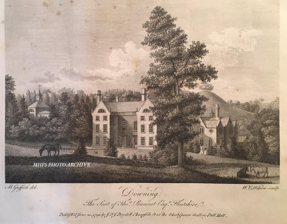
Downing Hall

Downing Hall was built in 1627 by the Pennant family near Whitford, Flintshire. It was later the home of Thomas Pennant, the naturalist, traveller and...

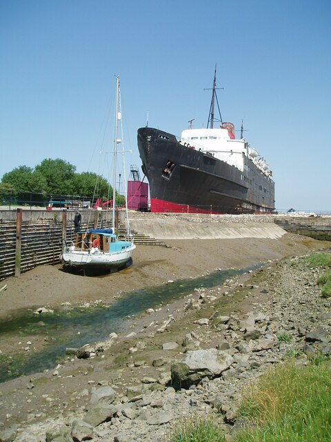
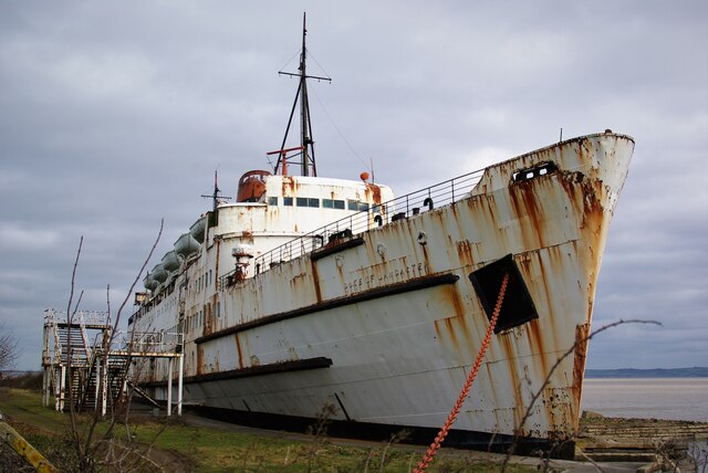
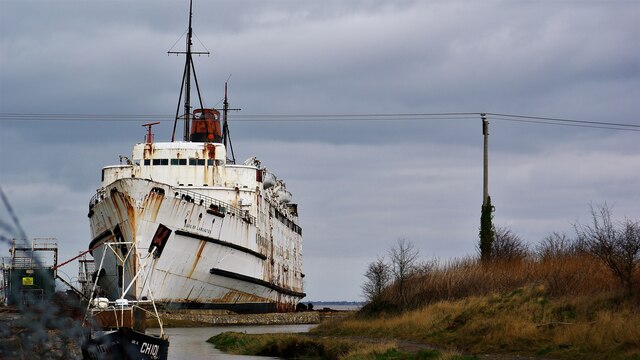
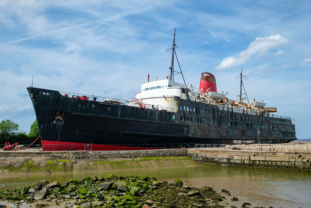
TSS Duke of Lancaster (1955)

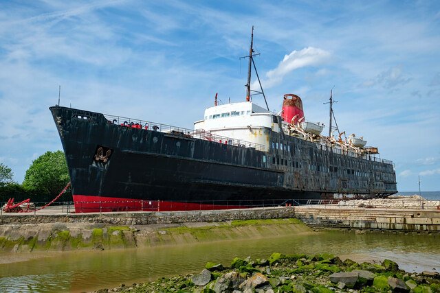
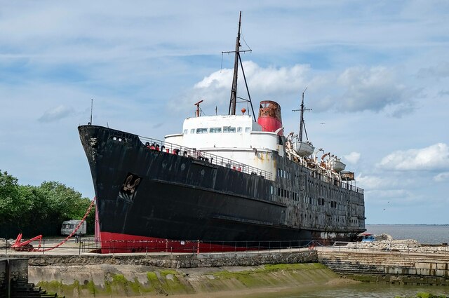
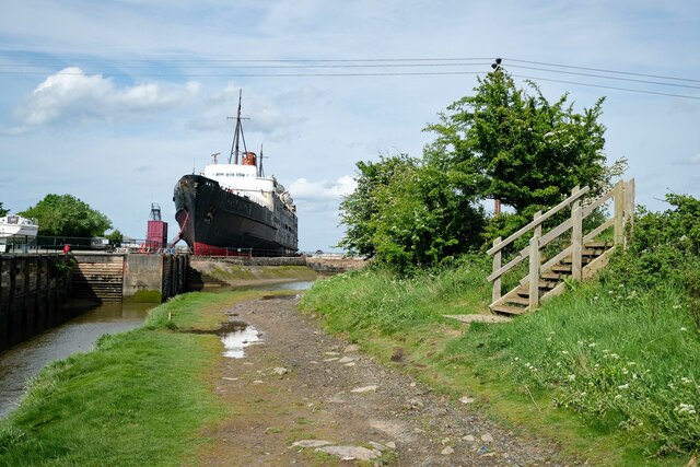
TSS Duke of Lancaster is a former railway steamer passenger ship that operated in Europe from 1956 to 1979, and is beached near Mostyn Docks, on the River...

Church of St Beuno and St Mary

The Church of St Beuno and St Mary is a Grade I listed church in Whitford, overlooking the estuary of the river Dee. The church has a well preserved late...

Whitford, Flintshire

Whitford (Welsh: Chwitffordd) is a village, community and an electoral ward near Holywell in Flintshire, northeast Wales. The population of both the community...

Nearby Amenities

Located within 500m of 53.313275,-3.262661
Source: Bing
Lat/Long: 53.3135861/-3.2555215
Source: Bing
Lat/Long: 53.3136525/-3.2559415
Source: PGS
Lat/Long: 53.3137702/-3.2563634
Source: Bing
Lat/Long: 53.3141161/-3.2572825
Source: Bing
Lat/Long: 53.3143035/-3.2577088
Source: Bing
Lat/Long: 53.3144935/-3.2581736
Source: Bing
Lat/Long: 53.3147084/-3.2588148
Source: Bing
Lat/Long: 53.3149233/-3.258934
Source: Bing
Lat/Long: 53.3152616/-3.259083
Source: Bing
Lat/Long: 53.315591/-3.259496
Source: Bing
Lat/Long: 53.316391/-3.2603476
Mostyn
Name Cy: Mostyn
Name En: Mostyn
Place: village
Wikidata: Q2424760
Lat/Long: 53.3146906/-3.2657174
Source: Bing
Lat/Long: 53.3170626/-3.260107
Source: Bing
Lat/Long: 53.3156457/-3.2598792
Source: Bing
Lat/Long: 53.3160361/-3.2602752
Source: Bing
Lat/Long: 53.3161442/-3.2602922
Factory
Warwick Chemicals
Man Made: works
Lat/Long: 53.315948/-3.2631862
Bus Stop
Rhewl-Mostyn, A548 / Lletty Hotel
Bus: yes
Naptan AtcoCode: 5120AWF80830
Naptan Bearing: SE
Naptan CommonName: Lletty Hotel
Naptan Indicator: before
Naptan Landmark: Lletty Hotel
Naptan LocalityName: Rhewl-Mostyn
Naptan NaptanCode: flidtad
Naptan Street: A548
Public Transport: platform
Source: naptan_import
Lat/Long: 53.3134176/-3.2599731
Communication Mobile Phone: yes
Height: 21
Man Made: mast
Tower Type: communication
Lat/Long: 53.3151289/-3.2638508
Power: pole
Lat/Long: 53.3163181/-3.2681063
Power: pole
Lat/Long: 53.316219/-3.2669584
Power: pole
Lat/Long: 53.3161635/-3.266348
Power: pole
Voltage: 33000
Lat/Long: 53.3168756/-3.2653918
Power: pole
Lat/Long: 53.3114674/-3.2687534
Power: pole
Lat/Long: 53.3114292/-3.2678838
Power: pole
Lat/Long: 53.3113654/-3.2661729
Barrier: stile
Source: survey
Lat/Long: 53.3122483/-3.2697818
Post Box
Collection Times: Mo-Fr 16:30; Sa 10:30
Operator: Royal Mail
Post Box Design: type_n
Post Box Type: lamp
Ref: CH8 13
Source: survey
Lat/Long: 53.3128564/-3.2675066
KJ's Kars
Addr City: Rhewl-Mostyn
Addr Housename: Bramblewood
Addr Postcode: CH8 9QE
Office: taxi
Phone: +44 7739 507746;+44 1745 560017
Website: http://www.kjskars.com/
Lat/Long: 53.3128567/-3.2685034
Barrier: stile
Source: survey
Lat/Long: 53.3123456/-3.2690296
Access: designated
Barrier: stile
Foot: designated
Source: survey
Lat/Long: 53.3122124/-3.2680051
Access: designated
Barrier: stile
Foot: designated
Lat/Long: 53.3118436/-3.2656288
Waste Basket
Source: survey
Waste: trash
Lat/Long: 53.310133/-3.2599992
Waste Basket
Source: survey
Waste: trash
Lat/Long: 53.3101991/-3.2610877
Grit Bin
Access: permissive
Source: survey
Lat/Long: 53.3103775/-3.2606343
Playground: swing
Source: survey
Lat/Long: 53.3096623/-3.2658637
Barrier: stile
Foot: designated
Motor Vehicle: no
Source: survey
Lat/Long: 53.309998/-3.2672725
Barrier: stile
Foot: designated
Source: survey
Lat/Long: 53.3103087/-3.2672494
Waste Basket
Source: survey
Waste: dog_excrement
Lat/Long: 53.3130593/-3.2693709
Bus Stop
Rhewl-Mostyn, Gloddaeth Terrace / Swan
Bus: yes
Naptan AtcoCode: 5120WDB22287
Naptan Bearing: W
Naptan CommonName: Swan
Naptan Indicator: nr
Naptan Landmark: Swan PH
Naptan LocalityName: Rhewl-Mostyn
Naptan NaptanCode: flimdwd
Naptan Street: Gloddaeth Terrace
Public Transport: platform
Shelter: yes
Source: naptan_import
Lat/Long: 53.3130662/-3.2692786
Telephone
Booth: K6
Covered: booth
Operator: BT
Phone: +44 1745 561344
Source: survey
Lat/Long: 53.3128457/-3.2675056
Grit Bin
Access: permissive
Source: survey
Lat/Long: 53.3132405/-3.2625174
Waste Basket
Source: survey
Waste: trash
Lat/Long: 53.313312/-3.2624189
Post Box
Collection Times: Mo-Sa 12:00
Operator: Royal Mail
Operator Wikidata: Q638098
Post Box Mounting: pier
Post Box Type: lamp
Ref: CH8 18
Royal Cypher: EIIR
Royal Cypher Wikidata: Q33102113
Source: survey
Survey Date: 2014-03-24
Lat/Long: 53.3138794/-3.262444
Recycling
Recycling Clothes: yes
Recycling Type: container
Lat/Long: 53.3128521/-3.2595412
Direction: 45
Maxweight: 7.5
Traffic Sign: maxweight
Lat/Long: 53.3125533/-3.25891
Mostyn Harbour
Seamark Type: harbour
Lat/Long: 53.3164651/-3.257628
Power: pole
Lat/Long: 53.3131659/-3.2554039
Power: pole
Lat/Long: 53.3136162/-3.2570198
Power: pole
Lat/Long: 53.3138591/-3.2579054
Power: pole
Lat/Long: 53.3141417/-3.2597606
Source: Bing
Lat/Long: 53.3173361/-3.2597983
Source: Bing
Lat/Long: 53.3166162/-3.2598753
Source: Bing
Lat/Long: 53.3163091/-3.2599493
Source: Bing
Lat/Long: 53.3161337/-3.2598643
Source: Bing
Lat/Long: 53.315891/-3.2598132
Source: Bing
Lat/Long: 53.3157071/-3.2593968
Source: Bing
Lat/Long: 53.3154684/-3.258976
Source: Bing
Lat/Long: 53.3147783/-3.2586625
Source: Bing
Lat/Long: 53.3149929/-3.2588309
Board Type: wildlife
Information: board
Tourism: information
Lat/Long: 53.3133654/-3.2553408
Bench
Backrest: yes
Colour: green
Direction: north
Seats: 3
Lat/Long: 53.3133107/-3.2553357
Street Lamp
Lat/Long: 53.309938/-3.2577089
Street Lamp
Lat/Long: 53.309962/-3.2579892
Street Lamp
Lat/Long: 53.3119793/-3.2596172
Street Lamp
Lat/Long: 53.3123664/-3.2594332
Street Lamp
Lat/Long: 53.3115141/-3.2598437
Street Lamp
Lat/Long: 53.3102919/-3.2606577
Street Lamp
Lat/Long: 53.3111124/-3.2599286
Street Lamp
Lat/Long: 53.3107571/-3.2602118
Street Lamp
Lat/Long: 53.3099848/-3.2613305
Street Lamp
Lat/Long: 53.3096977/-3.261822
Street Lamp
Lat/Long: 53.3091397/-3.2625874
Street Lamp
Lat/Long: 53.3094821/-3.263517
Street Lamp
Lat/Long: 53.3099294/-3.2644178
Street Lamp
Lat/Long: 53.3098944/-3.2659927
Street Lamp
Lat/Long: 53.3099383/-3.265222
Street Lamp
Lat/Long: 53.3100732/-3.2657556
Street Lamp
Lat/Long: 53.3102696/-3.2655253
Street Lamp
Lat/Long: 53.3115005/-3.2661358
Street Lamp
Lat/Long: 53.3120155/-3.2646235
Street Lamp
Lat/Long: 53.3119787/-3.2651367
Street Lamp
Lat/Long: 53.3122954/-3.2634148
Street Lamp
Lat/Long: 53.3118193/-3.2654905
Street Lamp
Lat/Long: 53.3125967/-3.2647083
Street Lamp
Lat/Long: 53.3123108/-3.2683098
Street Lamp
Lat/Long: 53.3124964/-3.2690874
Street Lamp
Lat/Long: 53.3127981/-3.2690483
Street Lamp
Lat/Long: 53.3131476/-3.2691138
Street Lamp
Lat/Long: 53.3129694/-3.2679257
Street Lamp
Lat/Long: 53.312957/-3.2670554
Street Lamp
Lat/Long: 53.313277/-3.2672027
Street Lamp
Lat/Long: 53.3129147/-3.2660765
Street Lamp
Lat/Long: 53.3133394/-3.2660118
Street Lamp
Lat/Long: 53.3139822/-3.2652562
Street Lamp
Lat/Long: 53.3128893/-3.2653391
Street Lamp
Lat/Long: 53.3129144/-3.2648293
Street Lamp
Lat/Long: 53.3131166/-3.2637849
Street Lamp
Lat/Long: 53.3147688/-3.2643938
Street Lamp
Lat/Long: 53.3136526/-3.2625908
Street Lamp
Lat/Long: 53.3133047/-3.2626054
Street Lamp
Lat/Long: 53.3134602/-3.2610125
Street Lamp
Lat/Long: 53.3144281/-3.263052
Street Lamp
Lat/Long: 53.3148345/-3.2634068
Street Lamp
Lat/Long: 53.3155837/-3.2643679
Railway: switch
Lat/Long: 53.3130877/-3.2586537
Railway: switch
Lat/Long: 53.3137389/-3.2599367
Line Management: branch
Power: pole
Lat/Long: 53.3151579/-3.2651082
Line Management: transition
Power: pole
Transformer: distribution
Lat/Long: 53.3149048/-3.263902
Power: pole
Lat/Long: 53.3144934/-3.2645321
Power: pole
Lat/Long: 53.3158067/-3.265689
Power: pole
Lat/Long: 53.3139688/-3.2640745
Power: pole
Lat/Long: 53.3164638/-3.2664516
Disused Amenity: post_box
Post Box Type: wall
Royal Cypher: GR
Lat/Long: 53.3128357/-3.2675606
Direction: 105
Generator Method: photovoltaic
Generator Output Electricity: yes
Generator Solar Modules: 10
Generator Source: solar
Generator Type: solar_photovoltaic_panel
Location: roof
Power: generator
Lat/Long: 53.3130877/-3.2681644
Direction: 105
Generator Method: photovoltaic
Generator Output Electricity: yes
Generator Solar Modules: 10
Generator Source: solar
Generator Type: solar_photovoltaic_panel
Location: roof
Power: generator
Lat/Long: 53.3131582/-3.2681242
Direction: 105
Generator Method: photovoltaic
Generator Output Electricity: yes
Generator Solar Modules: 10
Generator Source: solar
Generator Type: solar_photovoltaic_panel
Location: roof
Power: generator
Lat/Long: 53.3133025/-3.2680544
Direction: 105
Generator Method: photovoltaic
Generator Output Electricity: yes
Generator Solar Modules: 10
Generator Source: solar
Generator Type: solar_photovoltaic_panel
Location: roof
Power: generator
Lat/Long: 53.313365/-3.2680142
Direction: 195
Generator Method: photovoltaic
Generator Output Electricity: yes
Generator Solar Modules: 10
Generator Source: solar
Generator Type: solar_photovoltaic_panel
Location: roof
Power: generator
Lat/Long: 53.3134867/-3.2681134
Direction: 195
Generator Method: photovoltaic
Generator Output Electricity: yes
Generator Solar Modules: 10
Generator Source: solar
Generator Type: solar_photovoltaic_panel
Location: roof
Power: generator
Lat/Long: 53.3135156/-3.2682878
Direction: 195
Generator Method: photovoltaic
Generator Output Electricity: yes
Generator Solar Modules: 10
Generator Source: solar
Generator Type: solar_photovoltaic_panel
Location: roof
Power: generator
Lat/Long: 53.3135348/-3.2684165
Direction: 105
Generator Method: photovoltaic
Generator Output Electricity: yes
Generator Solar Modules: 10
Generator Source: solar
Generator Type: solar_photovoltaic_panel
Location: roof
Power: generator
Lat/Long: 53.3134487/-3.268548
Direction: 105
Generator Method: photovoltaic
Generator Output Electricity: yes
Generator Solar Modules: 10
Generator Source: solar
Generator Type: solar_photovoltaic_panel
Location: roof
Power: generator
Lat/Long: 53.313373/-3.2685748
Direction: 255
Generator Method: photovoltaic
Generator Output Electricity: yes
Generator Solar Modules: 16
Generator Source: solar
Generator Type: solar_photovoltaic_panel
Location: roof
Power: generator
Lat/Long: 53.3121903/-3.2683468
Direction: 80
Generator Method: photovoltaic
Generator Output Electricity: yes
Generator Solar Modules: 6
Generator Source: solar
Generator Type: solar_photovoltaic_panel
Location: roof
Power: generator
Lat/Long: 53.3124628/-3.2691702
Direction: 260
Generator Method: photovoltaic
Generator Output Electricity: yes
Generator Solar Modules: 8
Generator Source: solar
Generator Type: solar_photovoltaic_panel
Location: roof
Power: generator
Lat/Long: 53.3124451/-3.2692239
Direction: 260
Generator Method: photovoltaic
Generator Output Electricity: yes
Generator Solar Modules: 8
Generator Source: solar
Generator Type: solar_photovoltaic_panel
Location: roof
Power: generator
Lat/Long: 53.3124996/-3.2692426
Direction: 80
Generator Method: photovoltaic
Generator Output Electricity: yes
Generator Solar Modules: 8
Generator Source: solar
Generator Type: solar_photovoltaic_panel
Location: roof
Power: generator
Lat/Long: 53.3125092/-3.2691702
Direction: 170
Generator Method: photovoltaic
Generator Output Electricity: yes
Generator Solar Modules: 9
Generator Source: solar
Generator Type: solar_photovoltaic_panel
Location: roof
Power: generator
Lat/Long: 53.3127031/-3.2697898
Direction: 170
Generator Method: photovoltaic
Generator Output Electricity: yes
Generator Solar Modules: 7
Generator Source: solar
Generator Type: solar_photovoltaic_panel
Location: roof
Power: generator
Lat/Long: 53.3127464/-3.2695779
Direction: SSE
Generator Method: photovoltaic
Generator Output Electricity: yes
Generator Solar Modules: 6
Generator Source: solar
Generator Type: solar_photovoltaic_panel
Location: roof
Power: generator
Lat/Long: 53.3119788/-3.2642537
Direction: 125
Generator Method: photovoltaic
Generator Output Electricity: yes
Generator Solar Modules: 8
Generator Source: solar
Generator Type: solar_photovoltaic_panel
Location: roof
Power: generator
Lat/Long: 53.3089644/-3.2625639
Direction: 215
Generator Method: photovoltaic
Generator Output Electricity: yes
Generator Solar Modules: 5
Generator Source: solar
Generator Type: solar_photovoltaic_panel
Location: roof
Power: generator
Lat/Long: 53.3099039/-3.2620724
Direction: 215
Generator Method: photovoltaic
Generator Output Electricity: yes
Generator Solar Modules: 10
Generator Source: solar
Generator Type: solar_photovoltaic_panel
Location: roof
Power: generator
Lat/Long: 53.3092208/-3.2604772
Direction: SSE
Generator Method: photovoltaic
Generator Output Electricity: yes
Generator Solar Modules: 7
Generator Source: solar
Generator Type: solar_photovoltaic_panel
Location: roof
Power: generator
Lat/Long: 53.3093618/-3.2594848
Direction: 175
Generator Method: photovoltaic
Generator Output Electricity: yes
Generator Solar Modules: 10
Generator Source: solar
Generator Type: solar_photovoltaic_panel
Location: roof
Power: generator
Lat/Long: 53.3096343/-3.2583287
Traffic Signals
Traffic Signals Direction: backward
Lat/Long: 53.3138642/-3.2607364
Traffic Signals
Traffic Signals Direction: forward
Lat/Long: 53.3135843/-3.260339
Traffic Signals
Traffic Signals Direction: backward
Lat/Long: 53.3141978/-3.2604301
Bus Stop
Rhewl-Mostyn, Wirral View Road / Wirral View
Bus: yes
Naptan AtcoCode: 5120AWF80992
Naptan Bearing: SE
Naptan CommonName: Wirral View
Naptan Crossing: Wirral View
Naptan Indicator: before
Naptan LocalityName: Rhewl-Mostyn
Naptan NaptanCode: flidtag
Naptan Street: Wirral View Road
Public Transport: platform
Source: naptan_import
Lat/Long: 53.3139476/-3.2624965
Bus Stop
Rhewl-Mostyn, Wirral View Road / Wirral View
Bus: yes
Naptan AtcoCode: 5120WDB22463
Naptan Bearing: NW
Naptan CommonName: Wirral View
Naptan Crossing: Wirral View
Naptan Indicator: after
Naptan LocalityName: Rhewl-Mostyn
Naptan NaptanCode: flimjtg
Naptan Street: Wirral View Road
Public Transport: platform
Source: naptan_import
Lat/Long: 53.3139562/-3.2626334
Bus Stop
Rhewl-Mostyn, A548 / Lletty Hotel
Bus: yes
Naptan AtcoCode: 5120WDB46566
Naptan Bearing: NW
Naptan CommonName: Lletty Hotel
Naptan Indicator: after
Naptan Landmark: Lletty Hotel
Naptan LocalityName: Rhewl-Mostyn
Naptan NaptanCode: flijgpt
Naptan Street: A548
Public Transport: platform
Source: naptan_import
Lat/Long: 53.3132503/-3.2600754
The data included in this document is from www.openstreetmap.org. The data is made available under ODbL.

Have you been to Mostyn?

Leave your review of Mostyn below (or comments, questions and feedback).